

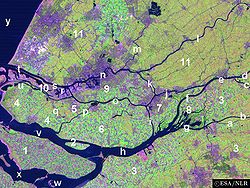
Hoeksche Waard
Encyclopedia
Island
An island or isle is any piece of sub-continental land that is surrounded by water. Very small islands such as emergent land features on atolls can be called islets, cays or keys. An island in a river or lake may be called an eyot , or holm...
between the Oude Maas
Oude Maas
The Oude Maas is a distributary of the Rhine River, and a former distributary of the Maas River, in the Dutch province of South Holland. It begins at the city of Dordrecht where the Beneden Merwede river splits into the Noord River and the Oude Maas...
, Dordtsche Kil
Dordtsche Kil
The Dordtsche Kil is a short river in South Holland in the Netherlands. The river is tidal and forms the connection between the Oude Maas river and the Hollands Diep...
, Hollands Diep
Hollands Diep
Hollands Diep is a wide river in the Netherlands and an estuary of the Rhine and Meuse river. Through the Scheldt-Rhine Canal it connects to the Scheldt river and Antwerp....
, Haringvliet
Haringvliet
The Haringvliet is a large inlet of the North Sea, in the province of South Holland in the Netherlands. It is an important estuary of the Rhine-Meuse delta.Near Numansdorp, the Hollands Diep splits into the Haringvliet and the Volkerak estuaries...
and Spui river
River
A river is a natural watercourse, usually freshwater, flowing towards an ocean, a lake, a sea, or another river. In a few cases, a river simply flows into the ground or dries up completely before reaching another body of water. Small rivers may also be called by several other names, including...
s in the province
Province
A province is a territorial unit, almost always an administrative division, within a country or state.-Etymology:The English word "province" is attested since about 1330 and derives from the 13th-century Old French "province," which itself comes from the Latin word "provincia," which referred to...
of Zuid Holland in the Netherlands
Netherlands
The Netherlands is a constituent country of the Kingdom of the Netherlands, located mainly in North-West Europe and with several islands in the Caribbean. Mainland Netherlands borders the North Sea to the north and west, Belgium to the south, and Germany to the east, and shares maritime borders...
. The island is a mostly agricultural
Agriculture
Agriculture is the cultivation of animals, plants, fungi and other life forms for food, fiber, and other products used to sustain life. Agriculture was the key implement in the rise of sedentary human civilization, whereby farming of domesticated species created food surpluses that nurtured the...
region, south of Rotterdam
Rotterdam
Rotterdam is the second-largest city in the Netherlands and one of the largest ports in the world. Starting as a dam on the Rotte river, Rotterdam has grown into a major international commercial centre...
. The Hoeksche Waard consists of reclaimed land (polder
Polder
A polder is a low-lying tract of land enclosed by embankments known as dikes, that forms an artificial hydrological entity, meaning it has no connection with outside water other than through manually-operated devices...
s): after the Saint Elisabeth flood
St. Elizabeth's flood (1421)
The St. Elizabeth's flood of 1421 was a flooding of an area in what is now the Netherlands. It takes its name from the feast day of Saint Elisabeth of Hungary which was formerly November 19....
of 1421 most of the area was flooded. The land has been reclaimed gradually in the following centuries.
The Hoeksche Waard consists of the following municipalities
Municipality
A municipality is essentially an urban administrative division having corporate status and usually powers of self-government. It can also be used to mean the governing body of a municipality. A municipality is a general-purpose administrative subdivision, as opposed to a special-purpose district...
:
- BinnenmaasBinnenmaasBinnenmaas is a municipality in the western Netherlands, in the province of South Holland. The municipality had a population of 19,245 in 2004, and covers an area of 54.91 km² of which 4.57 km² is water...
(villages Blaaksedijk, HeinenoordHeinenoordHeinenoord is a town in the Dutch province of South Holland on the island Hoekse Waard. It is located about 10 km south of Rotterdam, in the municipality of Binnenmaas.Heinenoord was a separate municipality until 1984, when it became part of Binnenmaas...
, GoidschalxoordGoidschalxoordGoidschalxoord is a small village in the Dutch province of South Holland. It is located about 5 km east of Oud-Beijerland, in the municipality of Binnenmaas.Goidschalxoord was a separate municipality between 1817 and 1855, when it merged with Heinenoord....
, MaasdamMaasdamMaasdam is a village in the Dutch province of South Holland. It is located about 14 km south of the city of Rotterdam, in the municipality of Binnenmaas.Maasdam was a separate municipality until 1984, when it became part of Binnenmaas.-External links:...
, MijnsheerenlandMijnsheerenlandMijnsheerenland is a village on the Hoeksche Waard in the Dutch province of South Holland with 4,435 inhabitants . It is located on the shores of the Binnenbedijkte Maas about 14 km south of the city of Rotterdam, in the municipality of Binnenmaas...
, PuttershoekPuttershoekPuttershoek is a town and former municipality in the western Netherlands. It is located on the banks of the Oude Maas, on the island Hoeksche Waard, in the province of South Holland. On January 1, 1984, the municipality of Puttershoek was merged with several others into Binnenmaas...
, WestmaasWestmaasWestmaas is a village in the Dutch province of South Holland. It is located about 14 km south of the city of Rotterdam, next to Mijnsheerenland in the municipality of Binnenmaas....
and 's-Gravendeel's-Gravendeels-Gravendeel is a town and former municipality in the western Netherlands, in the province of South Holland. The former municipality covered an area of 20.69 km² of which 1.77 km² is water.Its population was 9,023 in January 2007.The municipality of 's-Gravendeel was merged with...
) - CromstrijenCromstrijenCromstrijen is a municipality on the Hoeksche Waard Island in the western Netherlands, in the province of South Holland. The municipality covers an area of 70.31 km² of which 15.94 km² is water...
(villages KlaaswaalKlaaswaalKlaaswaal is a village in the Dutch province of South Holland. It is centrally located on one of the islands of South Holland called the Hoeksche_Waard...
and NumansdorpNumansdorpNumansdorp is a village in the Municipal Cromstrijen in the province South Holland in the Netherlands.On the 31st December 2004 Numansdorp had 9910 residents according to the municipal website ....
) - KorendijkKorendijkKorendijk is a municipality on the Hoeksche Waard Island in the western Netherlands, in the province of South Holland...
(villages GoudswaardGoudswaardGoudswaard is a town in the Dutch province of South Holland. It is a part of the municipality of Korendijk, and lies about 6 km southwest of Spijkenisse.Goudswaard was a separate municipality between 1817 and 1984, when it became part of Korendijk....
, Nieuw-BeijerlandNieuw-BeijerlandNieuw-Beijerland is a town in the Dutch province of South Holland. It is a part of the municipality of Korendijk, and lies about 3 km south of Spijkenisse.In 2001, the town of Nieuw-Beijerland had 3200 inhabitants...
, PiershilPiershilPiershil is a town in the Dutch province of South Holland. It is a part of the municipality of Korendijk, and lies about 5 km south of Spijkenisse.In 2001, the town of Piershil had 1185 inhabitants...
and Zuid-BeijerlandZuid-BeijerlandZuid-Beijerland is a town in the Dutch province of South Holland. It is a part of the municipality of Korendijk, and lies about 10 km south of Spijkenisse.In 2001, the town of Zuid-Beijerland had 2407 inhabitants...
) - Oud-BeijerlandOud-BeijerlandOud-Beijerland is a town and municipality in the western Netherlands, in the province of South Holland. With a population of 23,797 in 2005, it is the most populated town on the Hoekse Waard island, located on the Oude Maas and Spui Rivers....
- StrijenStrijenStrijen is a town and municipality in the western Netherlands, in the province of South Holland. The municipality, covering an area of 57.72 km² , is located on the Hoeksche Waard island along the Hollands Diep estuary.Strijen hosts a public library, swimming pool, a small shopping centre and...
(villages CillaarshoekCillaarshoekCillaarshoek is a village in the western Netherlands. It is located in Strijen, South Holland, about 15 km south of Rotterdam.Cillaarshoek was a separate municipality between 1817 and 1832, when it became part of Maasdam.-References:...
, Mookhoek, Strijen and StrijensasStrijensasStrijensas is a village in the Dutch province of South Holland. It is located about 12 km southwest of the city of Dordrecht, in the municipality of Strijen.Strijensas was a separate municipality between 1817 and 1855, when it became part of Strijen....
)
The Hoeksche Waard is separated:
- from IJsselmonde island on the north by the Oude MaasOude MaasThe Oude Maas is a distributary of the Rhine River, and a former distributary of the Maas River, in the Dutch province of South Holland. It begins at the city of Dordrecht where the Beneden Merwede river splits into the Noord River and the Oude Maas...
(tunnel) - from Voorne-PuttenVoorne-Puttenthumb|225px|right|Satellite image of the [[Rhine]]-[[Meuse river|Meuse]] [[river delta|delta]], showing the island of Voorne-Putten Voorne-Putten is an island between the North Sea, the Brielse meer and the rivers Oude Maas, Spui and Haringvliet in the province of South Holland in the Netherlands...
island on the west by the Spui (ferry) - from the island of DordrechtDordrechtDordrecht , colloquially Dordt, historically in English named Dort, is a city and municipality in the western Netherlands, located in the province of South Holland. It is the fourth largest city of the province, having a population of 118,601 in 2009...
on the east by the Dordtsche KilDordtsche KilThe Dordtsche Kil is a short river in South Holland in the Netherlands. The river is tidal and forms the connection between the Oude Maas river and the Hollands Diep...
(tunnel) - from Goeree-OverflakkeeGoeree-OverflakkeeGoeree-Overflakkee is the southernmost delta island of the province of South Holland, Netherlands. It is separated from Voorne-Putten and Hoeksche Waard by the Haringvliet, from the mainland of North Brabant by the Volkerak, and from Schouwen-Duiveland by Lake Grevelingen.From west to east, it...
island on the southwest by the HaringvlietHaringvlietThe Haringvliet is a large inlet of the North Sea, in the province of South Holland in the Netherlands. It is an important estuary of the Rhine-Meuse delta.Near Numansdorp, the Hollands Diep splits into the Haringvliet and the Volkerak estuaries...
(bridge) - from the Province of North BrabantNorth BrabantNorth Brabant , sometimes called Brabant, is a province of the Netherlands, located in the south of the country, bordered by Belgium in the south, the Meuse River in the north, Limburg in the east and Zeeland in the west.- History :...
on the southeast by the Hollands DiepHollands DiepHollands Diep is a wide river in the Netherlands and an estuary of the Rhine and Meuse river. Through the Scheldt-Rhine Canal it connects to the Scheldt river and Antwerp....
(bridge)