
Hodge Hill
Encyclopedia
Birmingham
Birmingham is a city and metropolitan borough in the West Midlands of England. It is the most populous British city outside the capital London, with a population of 1,036,900 , and lies at the heart of the West Midlands conurbation, the second most populous urban area in the United Kingdom with a...
city centre, England
England
England is a country that is part of the United Kingdom. It shares land borders with Scotland to the north and Wales to the west; the Irish Sea is to the north west, the Celtic Sea to the south west, with the North Sea to the east and the English Channel to the south separating it from continental...
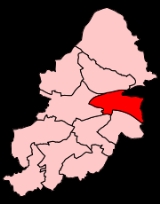
. It is also a council constituency, managed by its own district committee.
The constituency includes the smaller constituency ward and the wards of Bordesley Green
Bordesley Green
Bordesley Green is an inner-city area of Birmingham, England about two miles south-east from the city centre. It also contains a road of the same name. It is also a ward in the formal district of Hodge Hill. Neighbouring areas include, Alum Rock, Saltley, Small Heath and Yardley.Heartlands Hospital...
, Shard End
Shard End
Shard End is an area of Birmingham, England. It is also a ward within the formal district of Hodge Hill. Shard End borders Castle Bromwich to the north and Kingshurst to the east which are situated in the northern part of the neighbouring Metropolitan Borough of Solihull.-Pre-War:Before the end of...
and Washwood Heath
Washwood Heath
Washwood Heath is a ward in Birmingham, within the formal district of Hodge Hill, roughly two miles north-east of Birmingham city centre, England...
.
Politics
A by-election for the parliamentaryParliament of the United Kingdom
The Parliament of the United Kingdom of Great Britain and Northern Ireland is the supreme legislative body in the United Kingdom, British Crown dependencies and British overseas territories, located in London...
constituency of Hodge Hill took place on July 15, 2004 after the resignation of sitting MP Terry Davis. It was won by Liam Byrne
Liam Byrne
Liam Dominic Byrne is a British Labour Party politician who has been the Member of Parliament for Birmingham Hodge Hill since 2004, and was the Chief Secretary to the Treasury from 2009 to 2010 before being appointed Shadow Secretary of State for Work and Pensions on 20 January 2011.-Early...
.
The Hodge Hill Ward is currently represented by three Labour
Labour Party (UK)
The Labour Party is a centre-left democratic socialist party in the United Kingdom. It surpassed the Liberal Party in general elections during the early 1920s, forming minority governments under Ramsay MacDonald in 1924 and 1929-1931. The party was in a wartime coalition from 1940 to 1945, after...
councillors at the Birmingham City Council
Birmingham City Council
The Birmingham City Council is the body responsible for the governance of the City of Birmingham in England, which has been a metropolitan district since 1974. It is the most populated local authority in the United Kingdom with, following a reorganisation of boundaries in June 2004, 120 Birmingham...
; Gill Beddows, Mike Nangle (a former Lord Mayor
Lord Mayor
The Lord Mayor is the title of the Mayor of a major city, with special recognition.-Commonwealth of Nations:* In Australia it is a political position. Australian cities with Lord Mayors: Adelaide, Brisbane, Darwin, Hobart, Melbourne, Newcastle, Parramatta, Perth, Sydney, and Wollongong...
) and Anita Ward.
Hodge Hill Ward has adopted a Ward Support Officer with the current holder of the title being John Lerwill.
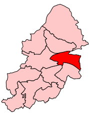
Geography
The boundaries of the Hodge Hill Ward are defined by the M6 motorwayM6 motorway
The M6 motorway runs from junction 19 of the M1 at the Catthorpe Interchange, near Rugby via Birmingham then heads north, passing Stoke-on-Trent, Manchester, Preston, Carlisle and terminating at the Gretna junction . Here, just short of the Scottish border it becomes the A74 which continues to...
to the north and A4040 outer circle
A4040 road
The A4040 is the Outer Ring Road in Birmingham, England. It is the route followed by the Birmingham Outer Circle bus route. It was formed mainly of redesignated old roads, unlike Birmingham's inner and middle ring road , which were mostly purpose built.Places along the route include:* Perry Barr*...
to the west.
Hodge Hill Common and the Cole Valley
River Cole, West Midlands
The River Cole is a river in the English Midlands. It rises in Redhill, near Kings Norton, South of Birmingham. After flowing through Birmingham, it passes Coleshill, to which it gave its name. It joins the River Blythe, of which it is a tributary, near Ladywalk, shortly before the Blythe meets...
, which are covered by the Kingfisher Country Park, are major areas of open space within the ward.
Population
The 2001 Population Census recorded 24,825 people living within the ward with a population density of 4,566 people per km² compared with 3,649 people per km² for Birmingham. Ethnic minorities represent 13.9% (3,442) of the ward's population as opposed to 29.6% for Birmingham in general.Transport
The B4114 Coleshill Road is the main road that separates the area. Stechford railway stationStechford railway station
Stechford railway station serves the Stechford area of Birmingham, England. The station, and all trains serving it, are operated by London Midland. It lies at the junction between the Birmingham to Coventry line, and the predominantly freight-only Stechford-Aston spur...
on the Coventry
Coventry
Coventry is a city and metropolitan borough in the county of West Midlands in England. Coventry is the 9th largest city in England and the 11th largest in the United Kingdom. It is also the second largest city in the English Midlands, after Birmingham, with a population of 300,848, although...
to Birmingham New Street line, as well as occasional services to Walsall
Walsall
Walsall is a large industrial town in the West Midlands of England. It is located northwest of Birmingham and east of Wolverhampton. Historically a part of Staffordshire, Walsall is a component area of the West Midlands conurbation and part of the Black Country.Walsall is the administrative...
via Aston
Aston
Aston is an area of the City of Birmingham, in the West Midlands of England. Lying to the north-east of the Birmingham city centre, Aston constitutes an electoral ward within the council constituency of Ladywood.-History:...
, serves the area.
Coleshill Road was the A47
A47 road
The A47 is a trunk road in England originally linking Birmingham to Great Yarmouth. Most of the section between Birmingham and Nuneaton is now classified as the B4114.-Route:...
before 1997, when the Heartlands Spine Road was completed.
Facilities
The local library is Glebe Farm Library which was the first library to be built in Birmingham after World War IIWorld War II
World War II, or the Second World War , was a global conflict lasting from 1939 to 1945, involving most of the world's nations—including all of the great powers—eventually forming two opposing military alliances: the Allies and the Axis...
. It was constructed out of pre-fabricated concrete sections and took one year to build. On April 22, 1952, it was opened to the public by Alderman Ralph Yates, then Lord Mayor of Birmingham. The Glebe Farm Local History Society gather at the library once every month.
Shopping facilities are mainly provided at the Fox & Goose
Fox & Goose
The Fox & Goose is a shopping district in Ward End, Birmingham, England, at the eastern end of Washwood Heath Road. It is named after the public house there...
; however, many travel to nearby Stechford to shop.