

History of geology
Encyclopedia
The history of geology is concerned with the development of the natural science of geology. Geology
is the scientific study of the origin, history, and structure of the Earth
. Throughout the ages geology provides essential theories and data that shape how society conceptualizes the Earth.
 Some of the first geological thoughts were about the origin of the Earth. Ancient Greece
developed some primary geological concepts concerning the origin of the Earth. Additionally, in the 4th century BC Aristotle
made critical observations of the slow rate of geological change. He observed the composition of the land and formulated a theory where the Earth changes at a slow rate and that these changes cannot be observed during one person’s lifetime. Aristotle developed one of the first evidentially based concepts connected to the geological realm regarding the rate at which the Earth physically changes.
However, it was his successor at the Lyceum
, the philosopher Theophrastus
, who made the greatest progress in antiquity in his work On Stones. He described many minerals and ores
both from local mines such as those at Laurium
near Athens
, and further afield. He also quite naturally discussed types of marble
and building materials like limestone
s, and attempted a primitive classification of the properties of minerals by their properties such as hardness.
Much later in the Roman
period, Pliny the Elder
produced a very extensive discussion of many more minerals and metal
s then widely used for practical ends. He was among the first to correctly identify the origin of amber
as a fossilized resin
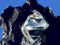
from trees by the observation of insects trapped within some pieces. He also laid the basis of crystallography
by recognising the octahedral habit of diamond
.
, whose works included the earliest writings on the geology of India, hypothesizing that the Indian subcontinent
was once a sea
:
Ibn Sina
(Avicenna, 981-1037), a Persian polymath
, made significant contributions to geology and the natural science
s (which he called Attabieyat) along with other natural philosophers such as Ikhwan AI-Safa
and many others. Ibn Sina wrote an encyclopaedic work entitled “Kitab al-Shifa
” (the Book of Cure, Healing or Remedy from ignorance), in which Part 2, Section 5, contains his commentary on Aristotle
's Mineralogy and Meteorology, in six chapters: Formation of mountain
s, The advantages of mountains in the formation of cloud
s; Sources of water
; Origin of earthquake
s; Formation of mineral
s; The diversity of earth’s terrain
.
In medieval China
, one of the most intriguing naturalists
was Shen Kuo
(1031-1095), a polymath
personality who dabbled in many fields of study in his age. In terms of geology, Shen Kuo is one of the first naturalists to have formulated a theory of geomorphology
. This was based on his observations of sedimentary uplift, soil erosion, deposition of silt
, and marine
fossil
s found in the Taihang Mountains
, located hundreds of miles from the Pacific Ocean
. He also formulated a theory of gradual climate change
, after his observation of ancient petrified bamboo
s found in a preserved state underground near Yanzhou (modern Yan'an
), in the dry northern climate of Shaanxi
province. He formulated a hypothesis for the process of land formation: based on his observation of fossil
shells in a geological stratum
in a mountain hundreds of miles from the ocean, he inferred that the land was formed by erosion
of the mountain
s and by deposition of silt
.
. The Earth’s strata can be defined as horizontal layers of rock having approximately the same composition throughout.
The popular mining industry during the 18th century both increased social interest and drove scientists to form more systematic and detailed studies of the composition of the Earth’s strata. From the increased societal interest of geology, in 1741 it became a specific field of study to be taught at the National Museum of Natural History in France. The controversial topic of the Earth’s origin continued to circulate between religious and scientific circles. Two feuding theories developed to explain the Earth’s origin with designated followers: the Neptunists
whose theory supported that of the Bible’s Great Flood and the Plutonists
who believed the Earth gradually formed over an immeasurable amount of time.
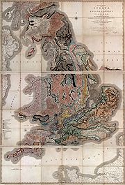
The dialogue about the creation of the Earth occurring within the scientific community and the evidence being uncovered in Civil Engineering
works during the 19th century drove the development of the stratigraphical column
; many of the concepts behind this invention can be attributed to William Smith
, Georges Cuvier
and Alexander Broignart. Also in this period, imperialism motivated countries to sponsor voyages of exploration to distant lands. Charles Darwin
made geological observations on such a voyage, providing evidential support of his revolutionary theory of evolution
. Again a religious debate ensued; two conflicting groups, uniformitarians
and catastrophists
, argued over the age of the Earth. Charles Lyell
, an influential uniformitarian, published his book in 1830 the “Principles of Geology” which proposed that the Earth changes very gradually and is immeasurably old.
The theory of Continental Drift
was proposed in 1912 by Alfred Wegener
. This idea, unaccepted at the time, suggested a method of continental movement that occurred throughout history. Supporting evidence of Continental Drift, including seafloor spreading
and paleomagnetism
, justified the theory of Continental Drift, which in the late 1960s was replaced and encompassed by Plate Tectonics
. In the latter half of the 20th century the approach to the study of geology changed to evaluating the Earth in a broader perspective. To coincide with this perspective, satellites were first used in the 1970s and are still currently in use by the Landsat Program
to produce images of the Earth that can be geologically studied.
 It was not until the 17th century that geology made great strides in its development. At this time, geology became its own entity in the world of natural science. It was discovered by the Christian world that different translations of the Bible
contained different versions of the biblical text. The one entity that remained consistent through all of the interpretations was that the Deluge had formed the world’s geology and geography
. To prove the Bible’s authenticity, individuals felt the need to demonstrate with scientific evidence that the Great Flood had in fact occurred
. With this enhanced desire for data came an increase in observations of the Earth’s composition, which in turn led to the discovery of fossil
s. Although theories that resulted from the heightened interest in the Earth’s composition were often manipulated to support the concept of the Deluge, a genuine outcome was a greater interest in the makeup of the Earth. Due to the strength of Christian beliefs during the 17th century, the theory of the origin of the Earth that was most widely accepted was A New Theory of the Earth
published in 1696, by William Whiston
. Whiston used Christian reasoning to “prove” that the Great Flood had occurred and that the flood had formed the rock strata of the Earth.
s and other components of the Earth’s crust
. Moreover, the increasing commercial importance of mining
in Europe during the mid to late 18th century made the possession of accurate knowledge about ore
s and their natural distribution essential. Scholars began to study the makeup of the Earth in a systematic manner, with detailed comparisons and descriptions not only of the land itself, but of the semi-precious metal
s that had such great value. For example, in 1774 Abraham Gottlob Werner
published the book “Von den äusserlichen Kennzeichen der Fossilien” (On the External Characters of Minerals), which brought him widespread recognition because he presented a detailed system for identifying specific minerals based on external characteristics. The more efficiently that productive land for mining could be found and that the semi-precious metals could be identified, the more money that could be made. This drive for economic success fueled geology into the limelight and made it a popular subject to pursue. With an increased number of people studying it, came more detailed observations and more information about the Earth.
During the eighteenth century, the story of the history of the Earth; namely the religious concept versus factual evidence once again became a popular discussion in society. In 1749 the French naturalist Georges-Louis Leclerc, Comte de Buffon published his Histoire Naturelle in which he attacked the popular Christian concepts of Whiston and other Christian theorists on the topic of the history of Earth
. From experimentation with cooling globes, he found that the age of the Earth was not only 4,000 or 5,500 years as inferred from the Bible, but rather 75,000 years. Another individual who attributed the history of the Earth to neither God nor the Bible was the philosopher Immanuel Kant
who published this concept in 1755 in his “Allgemeine Naturgeschichte und Theories des Himmels.” From the works of these educated men, as well as others, it became acceptable by the mid eighteenth century to question the age of the Earth. This questioning represented a turning point in the study of the Earth. It was now possible to study the history of the Earth from a scientific perspective rather than a religious one.
With science as a driving force behind the investigation of the Earth's history, the study of geology could now become a distinct field of science. First, the terminology and definition of what geological study consisted of had to be determined. The term geology was first used professionally in publications by two Genevian naturalists, Jean-André Deluc
and Horace-Bénédict de Saussure
. Geology was not well received as a term until it was used in the very popular encyclopedia, the Encyclopédie
, published in 1751 by Denis Diderot
. Once the term was coined as the study of the Earth and its history, geology slowly became a more prevalent and recognized science of its own standing that could be taught as a field of study at educational institutions. In 1741 the most well-known institution in the field of natural history, the National Museum of Natural History in France designated the first teaching position specifically for geology. This was an important step in the further development of geology as a science and in the recognition of the importance of widely distributing this knowledge.
After the designation of geology as a specific field of study in an institution, this subject flourished in educated society. By the 1770s two feuding theories with designated followers were established. These contrasting theories explained how the rock layers of the Earth’s surface had formed. The German geologist, Abraham Werner proposed the theory that the Earth’s layers, including basalt
and granite
, had formed as a precipitate from an ocean that covered the entire Earth, referring to the Deluge. Werner’s system was influential and those that believed his theory were known as Neptunists
. The Scottish naturalist, James Hutton
, argued against the theory of Neptunism. Hutton proposed the theory of Plutonism
; the Earth formed through the gradual solidification of a molten mass at a slow rate by the same processes that occurred throughout history and continues in present day. This led him to the conclusion that the Earth was immeasurably old and could not possibly fit within the limits of the inferences from the Bible. Plutonists believed that volcanic processes were the chief agent in rock formation, not water from a Great Flood.
 The Neptunists and Plutonists supplied necessary data to help complete the stratigraphical column in the early 19th century. The stratigraphical column can be defined as “the sequence of rock formations arranged according to their order of formation in time.” William Smith
, Georges Cuvier
and Alexander Broignart can all be recognized for their roles during this century in furthering the concept of fossil-based stratigraphy
. The English mineral surveyor William Smith found empirically that fossils were a highly effective means of distinguishing between otherwise similar formations of the landscape. At about the same time, the French comparative anatomist Georges Cuvier
realized that the relative ages of fossils could be determined from a geological standpoint; in terms of what layer of rock the fossils are located and the distance these layers of rock are from the surface of the Earth. Cuvier’s mineralogist colleague Alexandre Brogniart augmented Cuvier’s practices. Through the synthesis of these findings, Brogniart and Cuvier realized that different strata could be identified by fossil contents and thus each stratum could be assigned to a unique position in a sequence. After the publication of Cuvier and Broignart’s book, “Description Geologiques des Environs de Paris” in 1811, which outlined the concept of stratigraphy, came a great interest in this new method. Stratigraphy became very popular amongst geologists; many hoped to apply this concept to all the rocks of the Earth. During this century various geologists further refined the stratigraphical column to completion. For instance, in 1833 while Adam Sedgwick
was mapping rocks that he had established were from the Cambrian
Period, Charles Lyell
was elsewhere suggesting a subdivision of the Tertiary
Period; whilst Roderick Murchison
, mapping into Wales
from a different direction, was assigning the upper parts of Sedgewick's Cambrian to the lower parts of his own Silurian
Period. The stratigraphical column was significant because it now supplied a method to assign a relative age of these rocks by slotting them into different positions in their stratigraphical sequence. This created a global approach to dating the age of the Earth and allowed for further correlations to be drawn from similarities found in the makeup of the Earth’s crust in various countries.
 In early nineteenth-century Britain, catastrophism was adapted with the aim of reconciling geological science with religious traditions of the biblical Great Flood. In the early 1820s English geologists including William Buckland
and Adam Sedgwick interpreted "diluvial" deposits as the outcome of Noah's flood, but by the end of the decade they revised their opinions in favour of local inundations. Charles Lyell challenged catastrophism with the publication in 1830 of the first volume of his book Principles of Geology which presented a variety of geological evidence from England, France, Italy and Spain to prove Hutton’s ideas of gradualism correct. He argued that most geological change had been very gradual in human history. Lyell provided evidence for Uniformitarianism; a geological doctrine that processes occur at the same rates in the present as they did in the past and account for all of the Earth’s geological features. Lyell’s works were popular and widely read, the concept of Uniformitarianism had taken a strong hold in geological society.
During the same time that the stratigraphical column was being completed, imperialism
drove several countries in the early to mid 19th century to explore distant lands to expand their empires. This gave naturalists the opportunity to collect data on these voyages. In 1831 Captain Robert FitzRoy
, given charge of the coastal survey expedition of HMS Beagle
, sought a suitable naturalist to examine the land and give geological advice. This fell to Charles Darwin
, who had just completed his BA degree and had accompanied Sedgwick on a two week Welsh mapping expedition after taking his Spring course on geology. Fitzroy gave Darwin Lyell’s Principles of Geology, and Darwin became Lyell's first disciple, inventively theorising on uniformitarian
principles about the geological processes he saw, and challenging some of Lyell's ideas. He speculated about the Earth expanding to explain uplift, then on the basis of the idea that ocean areas sank as land was uplifted, theorised that coral atolls grew from fringing coral reef
s round sinking volcanic islands. This idea was confirmed when the Beagle surveyed the Cocos (Keeling) Islands
. Darwin's discovery of giant fossils helped to establish his reputation as a geologist, and his theorising about the causes of their extinction led to his theory of evolution
by natural selection
published in On the Origin of Species in 1859.
Economic motivations for the practical use of geological data caused governments to support geological research. During the 19th century the governments of several countries including Canada, Australia, Great Britain and the United States funded geological surveying that would produce geological maps of vast areas of the countries. Geological surveying provides the location of useful minerals and such information could be used to benefit the country’s mining industry. With the government funding of geological research, more individuals could study geology with better technology and techniques, leading to the expansion of the field of geology.
In the 19th century, scientific realms established the age of the Earth in terms of millions of years. By the early 20th century the Earth’s estimated age was 2 billion years. Radiometric dating
determined the age of minerals and rocks, which provided necessary data to help determine the Earth’s age. With this new discovery based on verifiable scientific data and the possible age of the Earth extending billions of years, the dates of the geological time scale could now be refined. Theories that did not comply with the scientific evidence that established the age of the Earth could no longer be accepted.
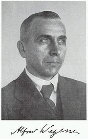 The determined age of the Earth as 2 billion years opened doors for theories of continental movement during this vast amount of time. In 1912 Alfred Wegener
proposed the theory of Continental Drift
. This theory suggests that the continents were joined together at a certain time in the past and formed a single landmass known as Pangaea
; thereafter they drifted like rafts over the ocean floor, finally reaching their present position. The shapes of continents and matching coastline geology between some continents indicated they were once attached together as Pangea. Additionally, the theory of continental drift offered a possible explanation as to the formation of mountains. From this, different theories developed as to how mountains were built. Unfortunately, Wegner’s ideas were not accepted during his lifetime and his theory of Continental Drift was not accepted until the 1960s.
In the 1960s new found evidence supported the theory of Continental Drift. The term Continental Drift was no longer used but was replaced by the concept of Plate Tectonics
that was well supported and accepted by almost all geologists by the end of the decade. Geophysical evidence suggested lateral motion of continents and that oceanic crust
is younger than continental crust. This geophysical evidence also spurred the hypotheses of seafloor spreading
and paleomagnetism
. The hypothesis of seafloor spreading, proposed by Robert S. Dietz
and Harry H. Hess, holds that the oceanic crust forms as the seafloor spreads apart along mid-ocean ridge
s. Paleomagnetism is the record of the orientation of the Earth’s magnetic field
recorded in magnetic minerals. British geophysicist S. K. Runcorn
suggested the concept of paleomagnetism from his finding that the continents had moved relative to the Earth’s magnetic poles.
on the Moon
, it can be argued that almost overnight, Gene Shoemaker
took the study of the Moon away from Lunar astronomers and gave it to Lunar geologists
.
In recent years, geology has continued its tradition as the study of the character and origin of the Earth, its surface features and internal structure. What changed in the later 20th century is the perspective of geological study. Geology was now studied using a more integrative approach, considering the Earth in a broader context encompassing the atmosphere, biosphere and hydrosphere. Satellites located in space that take wide scope photographs of the Earth provide such a perspective. In 1972, The Landsat Program, a series of satellite missions jointly managed by NASA
and the U.S. Geological Survey, began supplying satellite images that can be geologically analyzed. These images can be used to map major geological units, recognize and correlate rock types for vast regions and track the movements of Plate Tectonics. A few applications of this data include the ability to produce geologically detailed maps, locate sources of natural energy and predict possible natural disasters caused by plate shifts.
Geology
Geology is the science comprising the study of solid Earth, the rocks of which it is composed, and the processes by which it evolves. Geology gives insight into the history of the Earth, as it provides the primary evidence for plate tectonics, the evolutionary history of life, and past climates...
is the scientific study of the origin, history, and structure of the Earth
Earth
Earth is the third planet from the Sun, and the densest and fifth-largest of the eight planets in the Solar System. It is also the largest of the Solar System's four terrestrial planets...
. Throughout the ages geology provides essential theories and data that shape how society conceptualizes the Earth.
Antiquity
Ancient Greece
Ancient Greece is a civilization belonging to a period of Greek history that lasted from the Archaic period of the 8th to 6th centuries BC to the end of antiquity. Immediately following this period was the beginning of the Early Middle Ages and the Byzantine era. Included in Ancient Greece is the...
developed some primary geological concepts concerning the origin of the Earth. Additionally, in the 4th century BC Aristotle
Aristotle
Aristotle was a Greek philosopher and polymath, a student of Plato and teacher of Alexander the Great. His writings cover many subjects, including physics, metaphysics, poetry, theater, music, logic, rhetoric, linguistics, politics, government, ethics, biology, and zoology...
made critical observations of the slow rate of geological change. He observed the composition of the land and formulated a theory where the Earth changes at a slow rate and that these changes cannot be observed during one person’s lifetime. Aristotle developed one of the first evidentially based concepts connected to the geological realm regarding the rate at which the Earth physically changes.
However, it was his successor at the Lyceum
Lyceum
The lyceum is a category of educational institution defined within the education system of many countries, mainly in Europe. The definition varies between countries; usually it is a type of secondary school.-History:...
, the philosopher Theophrastus
Theophrastus
Theophrastus , a Greek native of Eresos in Lesbos, was the successor to Aristotle in the Peripatetic school. He came to Athens at a young age, and initially studied in Plato's school. After Plato's death he attached himself to Aristotle. Aristotle bequeathed to Theophrastus his writings, and...
, who made the greatest progress in antiquity in his work On Stones. He described many minerals and ores
Orés
Orés is a municipality in the Cinco Villas, in the province of Zaragoza, in the autonomous community of Aragon, Spain. It belongs to the comarca of Cinco Villas. It is placed 104 km to the northwest of the provincial capital city, Zaragoza. Its coordinates are: 42° 17' N, 1° 00' W, and is...
both from local mines such as those at Laurium
Laurium
Laurium or Lavrio is a town in southeastern part of Attica, Greece. It is the seat of the municipality of Lavreotiki...
near Athens
Athens
Athens , is the capital and largest city of Greece. Athens dominates the Attica region and is one of the world's oldest cities, as its recorded history spans around 3,400 years. Classical Athens was a powerful city-state...
, and further afield. He also quite naturally discussed types of marble
Marble
Marble is a metamorphic rock composed of recrystallized carbonate minerals, most commonly calcite or dolomite.Geologists use the term "marble" to refer to metamorphosed limestone; however stonemasons use the term more broadly to encompass unmetamorphosed limestone.Marble is commonly used for...
and building materials like limestone
Limestone
Limestone is a sedimentary rock composed largely of the minerals calcite and aragonite, which are different crystal forms of calcium carbonate . Many limestones are composed from skeletal fragments of marine organisms such as coral or foraminifera....
s, and attempted a primitive classification of the properties of minerals by their properties such as hardness.
Much later in the Roman
Ancient Rome
Ancient Rome was a thriving civilization that grew on the Italian Peninsula as early as the 8th century BC. Located along the Mediterranean Sea and centered on the city of Rome, it expanded to one of the largest empires in the ancient world....
period, Pliny the Elder
Pliny the Elder
Gaius Plinius Secundus , better known as Pliny the Elder, was a Roman author, naturalist, and natural philosopher, as well as naval and army commander of the early Roman Empire, and personal friend of the emperor Vespasian...
produced a very extensive discussion of many more minerals and metal
Metal
A metal , is an element, compound, or alloy that is a good conductor of both electricity and heat. Metals are usually malleable and shiny, that is they reflect most of incident light...
s then widely used for practical ends. He was among the first to correctly identify the origin of amber
Amber
Amber is fossilized tree resin , which has been appreciated for its color and natural beauty since Neolithic times. Amber is used as an ingredient in perfumes, as a healing agent in folk medicine, and as jewelry. There are five classes of amber, defined on the basis of their chemical constituents...
as a fossilized resin
Resin
Resin in the most specific use of the term is a hydrocarbon secretion of many plants, particularly coniferous trees. Resins are valued for their chemical properties and associated uses, such as the production of varnishes, adhesives, and food glazing agents; as an important source of raw materials...
from trees by the observation of insects trapped within some pieces. He also laid the basis of crystallography
Crystallography
Crystallography is the experimental science of the arrangement of atoms in solids. The word "crystallography" derives from the Greek words crystallon = cold drop / frozen drop, with its meaning extending to all solids with some degree of transparency, and grapho = write.Before the development of...
by recognising the octahedral habit of diamond
Diamond
In mineralogy, diamond is an allotrope of carbon, where the carbon atoms are arranged in a variation of the face-centered cubic crystal structure called a diamond lattice. Diamond is less stable than graphite, but the conversion rate from diamond to graphite is negligible at ambient conditions...
.
Middle Ages
Abu al-Rayhan al-Biruni (973-1048 AD) was one of the earliest Muslim geologistsIslamic geography
Geography and cartography in medieval Islam refers to the advancement of geography, cartography and the earth sciences in the medieval Islamic civilization....
, whose works included the earliest writings on the geology of India, hypothesizing that the Indian subcontinent
Indian subcontinent
The Indian subcontinent, also Indian Subcontinent, Indo-Pak Subcontinent or South Asian Subcontinent is a region of the Asian continent on the Indian tectonic plate from the Hindu Kush or Hindu Koh, Himalayas and including the Kuen Lun and Karakoram ranges, forming a land mass which extends...
was once a sea
Sea
A sea generally refers to a large body of salt water, but the term is used in other contexts as well. Most commonly, it means a large expanse of saline water connected with an ocean, and is commonly used as a synonym for ocean...
:
Ibn Sina
Avicenna
Abū ʿAlī al-Ḥusayn ibn ʿAbd Allāh ibn Sīnā , commonly known as Ibn Sīnā or by his Latinized name Avicenna, was a Persian polymath, who wrote almost 450 treatises on a wide range of subjects, of which around 240 have survived...
(Avicenna, 981-1037), a Persian polymath
Polymath
A polymath is a person whose expertise spans a significant number of different subject areas. In less formal terms, a polymath may simply be someone who is very knowledgeable...
, made significant contributions to geology and the natural science
Natural science
The natural sciences are branches of science that seek to elucidate the rules that govern the natural world by using empirical and scientific methods...
s (which he called Attabieyat) along with other natural philosophers such as Ikhwan AI-Safa
Brethren of Purity
The Brethren of Purity were a secret society of Muslim philosophers in Basra, Iraq, in the 10th century CE....
and many others. Ibn Sina wrote an encyclopaedic work entitled “Kitab al-Shifa
The Book of Healing
The Book of Healing is a scientific and philosophical encyclopedia written by Abū Alī ibn Sīnā from Asfahana, near Bukhara in Greater Persia. Despite its English title, it is not in fact concerned with medicine...
” (the Book of Cure, Healing or Remedy from ignorance), in which Part 2, Section 5, contains his commentary on Aristotle
Aristotle
Aristotle was a Greek philosopher and polymath, a student of Plato and teacher of Alexander the Great. His writings cover many subjects, including physics, metaphysics, poetry, theater, music, logic, rhetoric, linguistics, politics, government, ethics, biology, and zoology...
's Mineralogy and Meteorology, in six chapters: Formation of mountain
Mountain
Image:Himalaya_annotated.jpg|thumb|right|The Himalayan mountain range with Mount Everestrect 58 14 160 49 Chomo Lonzorect 200 28 335 52 Makalurect 378 24 566 45 Mount Everestrect 188 581 920 656 Tibetan Plateaurect 250 406 340 427 Rong River...
s, The advantages of mountains in the formation of cloud
Cloud
A cloud is a visible mass of liquid droplets or frozen crystals made of water and/or various chemicals suspended in the atmosphere above the surface of a planetary body. They are also known as aerosols. Clouds in Earth's atmosphere are studied in the cloud physics branch of meteorology...
s; Sources of water
Water
Water is a chemical substance with the chemical formula H2O. A water molecule contains one oxygen and two hydrogen atoms connected by covalent bonds. Water is a liquid at ambient conditions, but it often co-exists on Earth with its solid state, ice, and gaseous state . Water also exists in a...
; Origin of earthquake
Earthquake
An earthquake is the result of a sudden release of energy in the Earth's crust that creates seismic waves. The seismicity, seismism or seismic activity of an area refers to the frequency, type and size of earthquakes experienced over a period of time...
s; Formation of mineral
Mineral
A mineral is a naturally occurring solid chemical substance formed through biogeochemical processes, having characteristic chemical composition, highly ordered atomic structure, and specific physical properties. By comparison, a rock is an aggregate of minerals and/or mineraloids and does not...
s; The diversity of earth’s terrain
Terrain
Terrain, or land relief, is the vertical and horizontal dimension of land surface. When relief is described underwater, the term bathymetry is used...
.
In medieval China
China
Chinese civilization may refer to:* China for more general discussion of the country.* Chinese culture* Greater China, the transnational community of ethnic Chinese.* History of China* Sinosphere, the area historically affected by Chinese culture...
, one of the most intriguing naturalists
Natural history
Natural history is the scientific research of plants or animals, leaning more towards observational rather than experimental methods of study, and encompasses more research published in magazines than in academic journals. Grouped among the natural sciences, natural history is the systematic study...
was Shen Kuo
Shen Kuo
Shen Kuo or Shen Gua , style name Cunzhong and pseudonym Mengqi Weng , was a polymathic Chinese scientist and statesman of the Song Dynasty...
(1031-1095), a polymath
Polymath
A polymath is a person whose expertise spans a significant number of different subject areas. In less formal terms, a polymath may simply be someone who is very knowledgeable...
personality who dabbled in many fields of study in his age. In terms of geology, Shen Kuo is one of the first naturalists to have formulated a theory of geomorphology
Geomorphology
Geomorphology is the scientific study of landforms and the processes that shape them...
. This was based on his observations of sedimentary uplift, soil erosion, deposition of silt
Silt
Silt is granular material of a size somewhere between sand and clay whose mineral origin is quartz and feldspar. Silt may occur as a soil or as suspended sediment in a surface water body...
, and marine
Marine (ocean)
Marine is an umbrella term. As an adjective it is usually applicable to things relating to the sea or ocean, such as marine biology, marine ecology and marine geology...
fossil
Fossil
Fossils are the preserved remains or traces of animals , plants, and other organisms from the remote past...
s found in the Taihang Mountains
Taihang Mountains
The Taihang Mountains are a Chinese mountain range running down the eastern edge of the Loess Plateau in Henan, Shanxi and Hebei provinces. The range extends over 400 km from north to south and has an average elevation of 1,500 to 2,000 meters. The principal peak is Xiao Wutaishan...
, located hundreds of miles from the Pacific Ocean
Pacific Ocean
The Pacific Ocean is the largest of the Earth's oceanic divisions. It extends from the Arctic in the north to the Southern Ocean in the south, bounded by Asia and Australia in the west, and the Americas in the east.At 165.2 million square kilometres in area, this largest division of the World...
. He also formulated a theory of gradual climate change
Climate change
Climate change is a significant and lasting change in the statistical distribution of weather patterns over periods ranging from decades to millions of years. It may be a change in average weather conditions or the distribution of events around that average...
, after his observation of ancient petrified bamboo
Bamboo
Bamboo is a group of perennial evergreens in the true grass family Poaceae, subfamily Bambusoideae, tribe Bambuseae. Giant bamboos are the largest members of the grass family....
s found in a preserved state underground near Yanzhou (modern Yan'an
Yan'an
Yan'an , is a prefecture-level city in the Shanbei region of Shaanxi province in China, administering several counties, including Zhidan County , which served as the Chinese communist capital before the city of Yan'an proper took that role....
), in the dry northern climate of Shaanxi
Shaanxi
' is a province in the central part of Mainland China, and it includes portions of the Loess Plateau on the middle reaches of the Yellow River in addition to the Qinling Mountains across the southern part of this province...
province. He formulated a hypothesis for the process of land formation: based on his observation of fossil
Fossil
Fossils are the preserved remains or traces of animals , plants, and other organisms from the remote past...
shells in a geological stratum
Stratum
In geology and related fields, a stratum is a layer of sedimentary rock or soil with internally consistent characteristics that distinguish it from other layers...
in a mountain hundreds of miles from the ocean, he inferred that the land was formed by erosion
Erosion
Erosion is when materials are removed from the surface and changed into something else. It only works by hydraulic actions and transport of solids in the natural environment, and leads to the deposition of these materials elsewhere...
of the mountain
Mountain
Image:Himalaya_annotated.jpg|thumb|right|The Himalayan mountain range with Mount Everestrect 58 14 160 49 Chomo Lonzorect 200 28 335 52 Makalurect 378 24 566 45 Mount Everestrect 188 581 920 656 Tibetan Plateaurect 250 406 340 427 Rong River...
s and by deposition of silt
Silt
Silt is granular material of a size somewhere between sand and clay whose mineral origin is quartz and feldspar. Silt may occur as a soil or as suspended sediment in a surface water body...
.
Industrial Revolution
During the 17th century the heated debate between religion and science over the Earth’s origin further propelled interest in the Earth and brought about more systematic identification techniques of the Earth’s strataStratum
In geology and related fields, a stratum is a layer of sedimentary rock or soil with internally consistent characteristics that distinguish it from other layers...
. The Earth’s strata can be defined as horizontal layers of rock having approximately the same composition throughout.
The popular mining industry during the 18th century both increased social interest and drove scientists to form more systematic and detailed studies of the composition of the Earth’s strata. From the increased societal interest of geology, in 1741 it became a specific field of study to be taught at the National Museum of Natural History in France. The controversial topic of the Earth’s origin continued to circulate between religious and scientific circles. Two feuding theories developed to explain the Earth’s origin with designated followers: the Neptunists
Neptunism
Neptunism is a discredited and obsolete scientific theory of geology proposed by Abraham Gottlob Werner in the late 18th century that proposed rocks formed from the crystallisation of minerals in the early Earth's oceans....
whose theory supported that of the Bible’s Great Flood and the Plutonists
Plutonism
Plutonism is the geologic theory that the rocks forming the Earth were formed in fire by volcanic activity, with a continuing gradual process of weathering and erosion wearing away rocks, which were then deposited on the sea bed, re-formed into layers of sedimentary rock by heat and pressure, and...
who believed the Earth gradually formed over an immeasurable amount of time.
The dialogue about the creation of the Earth occurring within the scientific community and the evidence being uncovered in Civil Engineering
Civil engineering
Civil engineering is a professional engineering discipline that deals with the design, construction, and maintenance of the physical and naturally built environment, including works like roads, bridges, canals, dams, and buildings...
works during the 19th century drove the development of the stratigraphical column
Stratigraphy
Stratigraphy, a branch of geology, studies rock layers and layering . It is primarily used in the study of sedimentary and layered volcanic rocks....
; many of the concepts behind this invention can be attributed to William Smith
William Smith (geologist)
William 'Strata' Smith was an English geologist, credited with creating the first nationwide geological map. He is known as the "Father of English Geology" for collating the geological history of England and Wales into a single record, although recognition was very slow in coming...
, Georges Cuvier
Georges Cuvier
Georges Chrétien Léopold Dagobert Cuvier or Jean Léopold Nicolas Frédéric Cuvier , known as Georges Cuvier, was a French naturalist and zoologist...
and Alexander Broignart. Also in this period, imperialism motivated countries to sponsor voyages of exploration to distant lands. Charles Darwin
Charles Darwin
Charles Robert Darwin FRS was an English naturalist. He established that all species of life have descended over time from common ancestry, and proposed the scientific theory that this branching pattern of evolution resulted from a process that he called natural selection.He published his theory...
made geological observations on such a voyage, providing evidential support of his revolutionary theory of evolution
Evolution
Evolution is any change across successive generations in the heritable characteristics of biological populations. Evolutionary processes give rise to diversity at every level of biological organisation, including species, individual organisms and molecules such as DNA and proteins.Life on Earth...
. Again a religious debate ensued; two conflicting groups, uniformitarians
Uniformitarianism (science)
In the philosophy of naturalism, the uniformitarianism assumption is that the same natural laws and processes that operate in the universe now, have always operated in the universe in the past and apply everywhere in the universe. It has included the gradualistic concept that "the present is the...
and catastrophists
Catastrophism
Catastrophism is the theory that the Earth has been affected in the past by sudden, short-lived, violent events, possibly worldwide in scope. The dominant paradigm of modern geology is uniformitarianism , in which slow incremental changes, such as erosion, create the Earth's appearance...
, argued over the age of the Earth. Charles Lyell
Charles Lyell
Sir Charles Lyell, 1st Baronet, Kt FRS was a British lawyer and the foremost geologist of his day. He is best known as the author of Principles of Geology, which popularised James Hutton's concepts of uniformitarianism – the idea that the earth was shaped by slow-moving forces still in operation...
, an influential uniformitarian, published his book in 1830 the “Principles of Geology” which proposed that the Earth changes very gradually and is immeasurably old.
The theory of Continental Drift
Continental drift
Continental drift is the movement of the Earth's continents relative to each other. The hypothesis that continents 'drift' was first put forward by Abraham Ortelius in 1596 and was fully developed by Alfred Wegener in 1912...
was proposed in 1912 by Alfred Wegener
Alfred Wegener
Alfred Lothar Wegener was a German scientist, geophysicist, and meteorologist.He is most notable for his theory of continental drift , proposed in 1912, which hypothesized that the continents were slowly drifting around the Earth...
. This idea, unaccepted at the time, suggested a method of continental movement that occurred throughout history. Supporting evidence of Continental Drift, including seafloor spreading
Seafloor spreading
Seafloor spreading is a process that occurs at mid-ocean ridges, where new oceanic crust is formed through volcanic activity and then gradually moves away from the ridge. Seafloor spreading helps explain continental drift in the theory of plate tectonics....
and paleomagnetism
Paleomagnetism
Paleomagnetism is the study of the record of the Earth's magnetic field in rocks. Certain minerals in rocks lock-in a record of the direction and intensity of the magnetic field when they form. This record provides information on the past behavior of Earth's magnetic field and the past location of...
, justified the theory of Continental Drift, which in the late 1960s was replaced and encompassed by Plate Tectonics
Plate tectonics
Plate tectonics is a scientific theory that describes the large scale motions of Earth's lithosphere...
. In the latter half of the 20th century the approach to the study of geology changed to evaluating the Earth in a broader perspective. To coincide with this perspective, satellites were first used in the 1970s and are still currently in use by the Landsat Program
Landsat program
The Landsat program is the longest running enterprise for acquisition of satellite imagery of Earth. On July 26, 1972 the Earth Resources Technology Satellite was launched. This was eventually renamed to Landsat. The most recent, Landsat 7, was launched on April 15, 1999. The instruments on the...
to produce images of the Earth that can be geologically studied.
17th century
Bible
The Bible refers to any one of the collections of the primary religious texts of Judaism and Christianity. There is no common version of the Bible, as the individual books , their contents and their order vary among denominations...
contained different versions of the biblical text. The one entity that remained consistent through all of the interpretations was that the Deluge had formed the world’s geology and geography
Geography
Geography is the science that studies the lands, features, inhabitants, and phenomena of Earth. A literal translation would be "to describe or write about the Earth". The first person to use the word "geography" was Eratosthenes...
. To prove the Bible’s authenticity, individuals felt the need to demonstrate with scientific evidence that the Great Flood had in fact occurred
Flood geology
Flood geology is the interpretation of the geological history of the Earth in terms of the global flood described in Genesis 6–9. Similar views played a part in the early development of the science of geology, even after the Biblical chronology had been rejected by geologists in favour of an...
. With this enhanced desire for data came an increase in observations of the Earth’s composition, which in turn led to the discovery of fossil
Fossil
Fossils are the preserved remains or traces of animals , plants, and other organisms from the remote past...
s. Although theories that resulted from the heightened interest in the Earth’s composition were often manipulated to support the concept of the Deluge, a genuine outcome was a greater interest in the makeup of the Earth. Due to the strength of Christian beliefs during the 17th century, the theory of the origin of the Earth that was most widely accepted was A New Theory of the Earth
A New Theory of the Earth
A New Theory of the Earth was a book written by William Whiston, in which he presented a description of the divine creation of the Earth and a posited global flood. He also postulated that the earth originated from the atmosphere of a comet and that all major changes in earth's history could be...
published in 1696, by William Whiston
William Whiston
William Whiston was an English theologian, historian, and mathematician. He is probably best known for his translation of the Antiquities of the Jews and other works by Josephus, his A New Theory of the Earth, and his Arianism...
. Whiston used Christian reasoning to “prove” that the Great Flood had occurred and that the flood had formed the rock strata of the Earth.
18th century
From this increased interest in the nature of the Earth and its origin, came a rise in the interest of mineralMineral
A mineral is a naturally occurring solid chemical substance formed through biogeochemical processes, having characteristic chemical composition, highly ordered atomic structure, and specific physical properties. By comparison, a rock is an aggregate of minerals and/or mineraloids and does not...
s and other components of the Earth’s crust
Crust (geology)
In geology, the crust is the outermost solid shell of a rocky planet or natural satellite, which is chemically distinct from the underlying mantle...
. Moreover, the increasing commercial importance of mining
Mining
Mining is the extraction of valuable minerals or other geological materials from the earth, from an ore body, vein or seam. The term also includes the removal of soil. Materials recovered by mining include base metals, precious metals, iron, uranium, coal, diamonds, limestone, oil shale, rock...
in Europe during the mid to late 18th century made the possession of accurate knowledge about ore
Ore
An ore is a type of rock that contains minerals with important elements including metals. The ores are extracted through mining; these are then refined to extract the valuable element....
s and their natural distribution essential. Scholars began to study the makeup of the Earth in a systematic manner, with detailed comparisons and descriptions not only of the land itself, but of the semi-precious metal
Metal
A metal , is an element, compound, or alloy that is a good conductor of both electricity and heat. Metals are usually malleable and shiny, that is they reflect most of incident light...
s that had such great value. For example, in 1774 Abraham Gottlob Werner
Abraham Gottlob Werner
Abraham Gottlob Werner , was a German geologist who set out an early theory about the stratification of the Earth's crust and coined the word Neptunism...
published the book “Von den äusserlichen Kennzeichen der Fossilien” (On the External Characters of Minerals), which brought him widespread recognition because he presented a detailed system for identifying specific minerals based on external characteristics. The more efficiently that productive land for mining could be found and that the semi-precious metals could be identified, the more money that could be made. This drive for economic success fueled geology into the limelight and made it a popular subject to pursue. With an increased number of people studying it, came more detailed observations and more information about the Earth.
During the eighteenth century, the story of the history of the Earth; namely the religious concept versus factual evidence once again became a popular discussion in society. In 1749 the French naturalist Georges-Louis Leclerc, Comte de Buffon published his Histoire Naturelle in which he attacked the popular Christian concepts of Whiston and other Christian theorists on the topic of the history of Earth
History of Earth
The history of the Earth describes the most important events and fundamental stages in the development of the planet Earth from its formation 4.578 billion years ago to the present day. Nearly all branches of natural science have contributed to the understanding of the main events of the Earth's...
. From experimentation with cooling globes, he found that the age of the Earth was not only 4,000 or 5,500 years as inferred from the Bible, but rather 75,000 years. Another individual who attributed the history of the Earth to neither God nor the Bible was the philosopher Immanuel Kant
Immanuel Kant
Immanuel Kant was a German philosopher from Königsberg , researching, lecturing and writing on philosophy and anthropology at the end of the 18th Century Enlightenment....
who published this concept in 1755 in his “Allgemeine Naturgeschichte und Theories des Himmels.” From the works of these educated men, as well as others, it became acceptable by the mid eighteenth century to question the age of the Earth. This questioning represented a turning point in the study of the Earth. It was now possible to study the history of the Earth from a scientific perspective rather than a religious one.
With science as a driving force behind the investigation of the Earth's history, the study of geology could now become a distinct field of science. First, the terminology and definition of what geological study consisted of had to be determined. The term geology was first used professionally in publications by two Genevian naturalists, Jean-André Deluc
Jean-André Deluc
Jean-André Deluc or de Luc was a Swiss geologist and meteorologist.-Life:He was born at Geneva, descended from a family which had emigrated from Lucca and settled at Geneva in the 15th century...
and Horace-Bénédict de Saussure
Horace-Bénédict de Saussure
200px|thumb|Portrait of Horace-Bénédict de Saussure Horace-Bénédict de Saussure was a Genevan aristocrat, physicist and Alpine traveller, often considered the founder of alpinism, and considered to be the first person to build a successful solar oven.-Life and work:Saussure was born in Conches,...
. Geology was not well received as a term until it was used in the very popular encyclopedia, the Encyclopédie
Encyclopédie
Encyclopédie, ou dictionnaire raisonné des sciences, des arts et des métiers was a general encyclopedia published in France between 1751 and 1772, with later supplements, revised editions, and translations. It was edited by Denis Diderot and Jean le Rond d'Alembert...
, published in 1751 by Denis Diderot
Denis Diderot
Denis Diderot was a French philosopher, art critic, and writer. He was a prominent person during the Enlightenment and is best known for serving as co-founder and chief editor of and contributor to the Encyclopédie....
. Once the term was coined as the study of the Earth and its history, geology slowly became a more prevalent and recognized science of its own standing that could be taught as a field of study at educational institutions. In 1741 the most well-known institution in the field of natural history, the National Museum of Natural History in France designated the first teaching position specifically for geology. This was an important step in the further development of geology as a science and in the recognition of the importance of widely distributing this knowledge.
After the designation of geology as a specific field of study in an institution, this subject flourished in educated society. By the 1770s two feuding theories with designated followers were established. These contrasting theories explained how the rock layers of the Earth’s surface had formed. The German geologist, Abraham Werner proposed the theory that the Earth’s layers, including basalt
Basalt
Basalt is a common extrusive volcanic rock. It is usually grey to black and fine-grained due to rapid cooling of lava at the surface of a planet. It may be porphyritic containing larger crystals in a fine matrix, or vesicular, or frothy scoria. Unweathered basalt is black or grey...
and granite
Granite
Granite is a common and widely occurring type of intrusive, felsic, igneous rock. Granite usually has a medium- to coarse-grained texture. Occasionally some individual crystals are larger than the groundmass, in which case the texture is known as porphyritic. A granitic rock with a porphyritic...
, had formed as a precipitate from an ocean that covered the entire Earth, referring to the Deluge. Werner’s system was influential and those that believed his theory were known as Neptunists
Neptunism
Neptunism is a discredited and obsolete scientific theory of geology proposed by Abraham Gottlob Werner in the late 18th century that proposed rocks formed from the crystallisation of minerals in the early Earth's oceans....
. The Scottish naturalist, James Hutton
James Hutton
James Hutton was a Scottish physician, geologist, naturalist, chemical manufacturer and experimental agriculturalist. He is considered the father of modern geology...
, argued against the theory of Neptunism. Hutton proposed the theory of Plutonism
Plutonism
Plutonism is the geologic theory that the rocks forming the Earth were formed in fire by volcanic activity, with a continuing gradual process of weathering and erosion wearing away rocks, which were then deposited on the sea bed, re-formed into layers of sedimentary rock by heat and pressure, and...
; the Earth formed through the gradual solidification of a molten mass at a slow rate by the same processes that occurred throughout history and continues in present day. This led him to the conclusion that the Earth was immeasurably old and could not possibly fit within the limits of the inferences from the Bible. Plutonists believed that volcanic processes were the chief agent in rock formation, not water from a Great Flood.
19th century
William Smith (geologist)
William 'Strata' Smith was an English geologist, credited with creating the first nationwide geological map. He is known as the "Father of English Geology" for collating the geological history of England and Wales into a single record, although recognition was very slow in coming...
, Georges Cuvier
Georges Cuvier
Georges Chrétien Léopold Dagobert Cuvier or Jean Léopold Nicolas Frédéric Cuvier , known as Georges Cuvier, was a French naturalist and zoologist...
and Alexander Broignart can all be recognized for their roles during this century in furthering the concept of fossil-based stratigraphy
Stratigraphy
Stratigraphy, a branch of geology, studies rock layers and layering . It is primarily used in the study of sedimentary and layered volcanic rocks....
. The English mineral surveyor William Smith found empirically that fossils were a highly effective means of distinguishing between otherwise similar formations of the landscape. At about the same time, the French comparative anatomist Georges Cuvier
Georges Cuvier
Georges Chrétien Léopold Dagobert Cuvier or Jean Léopold Nicolas Frédéric Cuvier , known as Georges Cuvier, was a French naturalist and zoologist...
realized that the relative ages of fossils could be determined from a geological standpoint; in terms of what layer of rock the fossils are located and the distance these layers of rock are from the surface of the Earth. Cuvier’s mineralogist colleague Alexandre Brogniart augmented Cuvier’s practices. Through the synthesis of these findings, Brogniart and Cuvier realized that different strata could be identified by fossil contents and thus each stratum could be assigned to a unique position in a sequence. After the publication of Cuvier and Broignart’s book, “Description Geologiques des Environs de Paris” in 1811, which outlined the concept of stratigraphy, came a great interest in this new method. Stratigraphy became very popular amongst geologists; many hoped to apply this concept to all the rocks of the Earth. During this century various geologists further refined the stratigraphical column to completion. For instance, in 1833 while Adam Sedgwick
Adam Sedgwick
Adam Sedgwick was one of the founders of modern geology. He proposed the Devonian period of the geological timescale...
was mapping rocks that he had established were from the Cambrian
Cambrian
The Cambrian is the first geological period of the Paleozoic Era, lasting from Mya ; it is succeeded by the Ordovician. Its subdivisions, and indeed its base, are somewhat in flux. The period was established by Adam Sedgwick, who named it after Cambria, the Latin name for Wales, where Britain's...
Period, Charles Lyell
Charles Lyell
Sir Charles Lyell, 1st Baronet, Kt FRS was a British lawyer and the foremost geologist of his day. He is best known as the author of Principles of Geology, which popularised James Hutton's concepts of uniformitarianism – the idea that the earth was shaped by slow-moving forces still in operation...
was elsewhere suggesting a subdivision of the Tertiary
Tertiary
The Tertiary is a deprecated term for a geologic period 65 million to 2.6 million years ago. The Tertiary covered the time span between the superseded Secondary period and the Quaternary...
Period; whilst Roderick Murchison
Roderick Murchison
Sir Roderick Impey Murchison, 1st Baronet KCB DCL FRS FRSE FLS PRGS PBA MRIA was a Scottish geologist who first described and investigated the Silurian system.-Early life and work:...
, mapping into Wales
Wales
Wales is a country that is part of the United Kingdom and the island of Great Britain, bordered by England to its east and the Atlantic Ocean and Irish Sea to its west. It has a population of three million, and a total area of 20,779 km²...
from a different direction, was assigning the upper parts of Sedgewick's Cambrian to the lower parts of his own Silurian
Silurian
The Silurian is a geologic period and system that extends from the end of the Ordovician Period, about 443.7 ± 1.5 Mya , to the beginning of the Devonian Period, about 416.0 ± 2.8 Mya . As with other geologic periods, the rock beds that define the period's start and end are well identified, but the...
Period. The stratigraphical column was significant because it now supplied a method to assign a relative age of these rocks by slotting them into different positions in their stratigraphical sequence. This created a global approach to dating the age of the Earth and allowed for further correlations to be drawn from similarities found in the makeup of the Earth’s crust in various countries.
William Buckland
The Very Rev. Dr William Buckland DD FRS was an English geologist, palaeontologist and Dean of Westminster, who wrote the first full account of a fossil dinosaur, which he named Megalosaurus...
and Adam Sedgwick interpreted "diluvial" deposits as the outcome of Noah's flood, but by the end of the decade they revised their opinions in favour of local inundations. Charles Lyell challenged catastrophism with the publication in 1830 of the first volume of his book Principles of Geology which presented a variety of geological evidence from England, France, Italy and Spain to prove Hutton’s ideas of gradualism correct. He argued that most geological change had been very gradual in human history. Lyell provided evidence for Uniformitarianism; a geological doctrine that processes occur at the same rates in the present as they did in the past and account for all of the Earth’s geological features. Lyell’s works were popular and widely read, the concept of Uniformitarianism had taken a strong hold in geological society.
During the same time that the stratigraphical column was being completed, imperialism
Imperialism
Imperialism, as defined by Dictionary of Human Geography, is "the creation and/or maintenance of an unequal economic, cultural, and territorial relationships, usually between states and often in the form of an empire, based on domination and subordination." The imperialism of the last 500 years,...
drove several countries in the early to mid 19th century to explore distant lands to expand their empires. This gave naturalists the opportunity to collect data on these voyages. In 1831 Captain Robert FitzRoy
Robert FitzRoy
Vice-Admiral Robert FitzRoy RN achieved lasting fame as the captain of HMS Beagle during Charles Darwin's famous voyage, and as a pioneering meteorologist who made accurate weather forecasting a reality...
, given charge of the coastal survey expedition of HMS Beagle
Second voyage of HMS Beagle
The second voyage of HMS Beagle, from 27 December 1831 to 2 October 1836, was the second survey expedition of HMS Beagle, under captain Robert FitzRoy who had taken over command of the ship on its first voyage after her previous captain committed suicide...
, sought a suitable naturalist to examine the land and give geological advice. This fell to Charles Darwin
Charles Darwin
Charles Robert Darwin FRS was an English naturalist. He established that all species of life have descended over time from common ancestry, and proposed the scientific theory that this branching pattern of evolution resulted from a process that he called natural selection.He published his theory...
, who had just completed his BA degree and had accompanied Sedgwick on a two week Welsh mapping expedition after taking his Spring course on geology. Fitzroy gave Darwin Lyell’s Principles of Geology, and Darwin became Lyell's first disciple, inventively theorising on uniformitarian
Uniformitarianism (science)
In the philosophy of naturalism, the uniformitarianism assumption is that the same natural laws and processes that operate in the universe now, have always operated in the universe in the past and apply everywhere in the universe. It has included the gradualistic concept that "the present is the...
principles about the geological processes he saw, and challenging some of Lyell's ideas. He speculated about the Earth expanding to explain uplift, then on the basis of the idea that ocean areas sank as land was uplifted, theorised that coral atolls grew from fringing coral reef
Coral reef
Coral reefs are underwater structures made from calcium carbonate secreted by corals. Coral reefs are colonies of tiny living animals found in marine waters that contain few nutrients. Most coral reefs are built from stony corals, which in turn consist of polyps that cluster in groups. The polyps...
s round sinking volcanic islands. This idea was confirmed when the Beagle surveyed the Cocos (Keeling) Islands
Cocos (Keeling) Islands
The Territory of the Cocos Islands, also called Cocos Islands and Keeling Islands, is a territory of Australia, located in the Indian Ocean, southwest of Christmas Island and approximately midway between Australia and Sri Lanka....
. Darwin's discovery of giant fossils helped to establish his reputation as a geologist, and his theorising about the causes of their extinction led to his theory of evolution
Evolution
Evolution is any change across successive generations in the heritable characteristics of biological populations. Evolutionary processes give rise to diversity at every level of biological organisation, including species, individual organisms and molecules such as DNA and proteins.Life on Earth...
by natural selection
Natural selection
Natural selection is the nonrandom process by which biologic traits become either more or less common in a population as a function of differential reproduction of their bearers. It is a key mechanism of evolution....
published in On the Origin of Species in 1859.
Economic motivations for the practical use of geological data caused governments to support geological research. During the 19th century the governments of several countries including Canada, Australia, Great Britain and the United States funded geological surveying that would produce geological maps of vast areas of the countries. Geological surveying provides the location of useful minerals and such information could be used to benefit the country’s mining industry. With the government funding of geological research, more individuals could study geology with better technology and techniques, leading to the expansion of the field of geology.
In the 19th century, scientific realms established the age of the Earth in terms of millions of years. By the early 20th century the Earth’s estimated age was 2 billion years. Radiometric dating
Radiometric dating
Radiometric dating is a technique used to date materials such as rocks, usually based on a comparison between the observed abundance of a naturally occurring radioactive isotope and its decay products, using known decay rates...
determined the age of minerals and rocks, which provided necessary data to help determine the Earth’s age. With this new discovery based on verifiable scientific data and the possible age of the Earth extending billions of years, the dates of the geological time scale could now be refined. Theories that did not comply with the scientific evidence that established the age of the Earth could no longer be accepted.
20th century
Alfred Wegener
Alfred Lothar Wegener was a German scientist, geophysicist, and meteorologist.He is most notable for his theory of continental drift , proposed in 1912, which hypothesized that the continents were slowly drifting around the Earth...
proposed the theory of Continental Drift
Continental drift
Continental drift is the movement of the Earth's continents relative to each other. The hypothesis that continents 'drift' was first put forward by Abraham Ortelius in 1596 and was fully developed by Alfred Wegener in 1912...
. This theory suggests that the continents were joined together at a certain time in the past and formed a single landmass known as Pangaea
Pangaea
Pangaea, Pangæa, or Pangea is hypothesized as a supercontinent that existed during the Paleozoic and Mesozoic eras about 250 million years ago, before the component continents were separated into their current configuration....
; thereafter they drifted like rafts over the ocean floor, finally reaching their present position. The shapes of continents and matching coastline geology between some continents indicated they were once attached together as Pangea. Additionally, the theory of continental drift offered a possible explanation as to the formation of mountains. From this, different theories developed as to how mountains were built. Unfortunately, Wegner’s ideas were not accepted during his lifetime and his theory of Continental Drift was not accepted until the 1960s.
In the 1960s new found evidence supported the theory of Continental Drift. The term Continental Drift was no longer used but was replaced by the concept of Plate Tectonics
Plate tectonics
Plate tectonics is a scientific theory that describes the large scale motions of Earth's lithosphere...
that was well supported and accepted by almost all geologists by the end of the decade. Geophysical evidence suggested lateral motion of continents and that oceanic crust
Oceanic crust
Oceanic crust is the part of Earth's lithosphere that surfaces in the ocean basins. Oceanic crust is primarily composed of mafic rocks, or sima, which is rich in iron and magnesium...
is younger than continental crust. This geophysical evidence also spurred the hypotheses of seafloor spreading
Seafloor spreading
Seafloor spreading is a process that occurs at mid-ocean ridges, where new oceanic crust is formed through volcanic activity and then gradually moves away from the ridge. Seafloor spreading helps explain continental drift in the theory of plate tectonics....
and paleomagnetism
Paleomagnetism
Paleomagnetism is the study of the record of the Earth's magnetic field in rocks. Certain minerals in rocks lock-in a record of the direction and intensity of the magnetic field when they form. This record provides information on the past behavior of Earth's magnetic field and the past location of...
. The hypothesis of seafloor spreading, proposed by Robert S. Dietz
Robert S. Dietz
Robert Sinclair Dietz was Professor of Geology at Arizona State University. Dietz was a marine geologist, geophysicist and oceanographer who conducted pioneering research along with Harry Hammond Hess concerning seafloor spreading, published as early as 1960–1961...
and Harry H. Hess, holds that the oceanic crust forms as the seafloor spreads apart along mid-ocean ridge
Mid-ocean ridge
A mid-ocean ridge is a general term for an underwater mountain system that consists of various mountain ranges , typically having a valley known as a rift running along its spine, formed by plate tectonics. This type of oceanic ridge is characteristic of what is known as an oceanic spreading...
s. Paleomagnetism is the record of the orientation of the Earth’s magnetic field
Magnetic field
A magnetic field is a mathematical description of the magnetic influence of electric currents and magnetic materials. The magnetic field at any given point is specified by both a direction and a magnitude ; as such it is a vector field.Technically, a magnetic field is a pseudo vector;...
recorded in magnetic minerals. British geophysicist S. K. Runcorn
Keith Runcorn
Stanley Keith Runcorn FRS was a British physicist whose paleomagnetic reconstruction of the relative motions of Europe and America revived the theory of continental drift and was a major contribution to plate tectonics.-Biography:He was born in Southport, Lancashire and graduated in engineering...
suggested the concept of paleomagnetism from his finding that the continents had moved relative to the Earth’s magnetic poles.
Modern geology
By applying sound stratigraphic principles to the distribution of cratersImpact crater
In the broadest sense, the term impact crater can be applied to any depression, natural or manmade, resulting from the high velocity impact of a projectile with a larger body...
on the Moon
Moon
The Moon is Earth's only known natural satellite,There are a number of near-Earth asteroids including 3753 Cruithne that are co-orbital with Earth: their orbits bring them close to Earth for periods of time but then alter in the long term . These are quasi-satellites and not true moons. For more...
, it can be argued that almost overnight, Gene Shoemaker
Eugene Merle Shoemaker
Eugene Merle Shoemaker , American geologist, was one of the founders of the fields of planetary science....
took the study of the Moon away from Lunar astronomers and gave it to Lunar geologists
Geology of the Moon
The geology of the Moon is quite different from that of the Earth...
.
In recent years, geology has continued its tradition as the study of the character and origin of the Earth, its surface features and internal structure. What changed in the later 20th century is the perspective of geological study. Geology was now studied using a more integrative approach, considering the Earth in a broader context encompassing the atmosphere, biosphere and hydrosphere. Satellites located in space that take wide scope photographs of the Earth provide such a perspective. In 1972, The Landsat Program, a series of satellite missions jointly managed by NASA
NASA
The National Aeronautics and Space Administration is the agency of the United States government that is responsible for the nation's civilian space program and for aeronautics and aerospace research...
and the U.S. Geological Survey, began supplying satellite images that can be geologically analyzed. These images can be used to map major geological units, recognize and correlate rock types for vast regions and track the movements of Plate Tectonics. A few applications of this data include the ability to produce geologically detailed maps, locate sources of natural energy and predict possible natural disasters caused by plate shifts.
See also
- History of geomagnetismHistory of geomagnetismThe history of geomagnetism is concerned with the history of the study of Earth's magnetic field. It encompasses the history of navigation using compasses, studies of the prehistoric magnetic field , and applications to plate tectonics.Magnetism has been known since prehistory, but knowledge of the...
- History of palaeontology
- History of scienceHistory of scienceThe history of science is the study of the historical development of human understandings of the natural world and the domains of the social sciences....
- Humboldtian scienceHumboldtian scienceHumboldtian science is a term given to the movement in science in the 19th century. The ideals and central themes of Humboldtian science are the result of the work of German scientist Alexander von Humboldt...
- Nicolas StenoNicolas StenoNicolas Steno |Latinized]] to Nicolaus Steno -gen. Nicolai Stenonis-, Italian Niccolo' Stenone) was a Danish pioneer in both anatomy and geology. Already in 1659 he decided not to accept anything simply written in a book, instead resolving to do research himself. He is considered the father of...
- Timeline of geologyTimeline of geologyTimeline of geology: see also geologic time scale.-Early works:* c. 1025 – Abū Rayhān al-Bīrūnī publishes the Kitab fi Tahqiq ma li'l-Hind , in which he discusses the geology of India and hypothesizes that it was once a sea....
- Timeline of the development of tectonophysicsTimeline of the development of tectonophysicsThe evolution of tectonophysics is closely linked to the history of the continental drift and plate tectonics hypotheses. The continental drift hypothesis had many flaws and scarce data. The fixist, the contracting Earth and the expanding Earth concepts had many flaws as well. Wegener had data for...
External links
- http://geology.com
- http://landsat.gsfc.nasa.gov