

History of Santa Barbara, California
Encyclopedia
Santa Barbara, California
Santa Barbara is the county seat of Santa Barbara County, California, United States. Situated on an east-west trending section of coastline, the longest such section on the West Coast of the United States, the city lies between the steeply-rising Santa Ynez Mountains and the Pacific Ocean...
, begins approximately 13,000 years ago with the arrival of the first Native Americans. The Spanish came in the 18th century to occupy and Christianize the area, which became part of Mexico
Mexico
The United Mexican States , commonly known as Mexico , is a federal constitutional republic in North America. It is bordered on the north by the United States; on the south and west by the Pacific Ocean; on the southeast by Guatemala, Belize, and the Caribbean Sea; and on the east by the Gulf of...
following the Mexican War of Independence
Mexican War of Independence
The Mexican War of Independence was an armed conflict between the people of Mexico and the Spanish colonial authorities which started on 16 September 1810. The movement, which became known as the Mexican War of Independence, was led by Mexican-born Spaniards, Mestizos and Amerindians who sought...
. In 1848, the expanding United States
United States
The United States of America is a federal constitutional republic comprising fifty states and a federal district...
acquired the town along with the rest of California as a result of defeating Mexico in the Mexican-American War. Santa Barbara transformed then from a dusty cluster of adobes into successively a rowdy, lawless Gold Rush
California Gold Rush
The California Gold Rush began on January 24, 1848, when gold was found by James W. Marshall at Sutter's Mill in Coloma, California. The first to hear confirmed information of the gold rush were the people in Oregon, the Sandwich Islands , and Latin America, who were the first to start flocking to...
era town; a Victorian-era health resort; a center of silent film
Silent film
A silent film is a film with no synchronized recorded sound, especially with no spoken dialogue. In silent films for entertainment the dialogue is transmitted through muted gestures, pantomime and title cards...
production; an oil
Petroleum
Petroleum or crude oil is a naturally occurring, flammable liquid consisting of a complex mixture of hydrocarbons of various molecular weights and other liquid organic compounds, that are found in geologic formations beneath the Earth's surface. Petroleum is recovered mostly through oil drilling...
boom town; a town supporting a military base and hospital during World War II; and finally it became the economically diverse resort destination it remains in the present day. Twice destroyed by earthquakes, in 1812 and 1925, it most recently has rebuilt itself in a Spanish Colonial
Spanish Colonial Revival Style architecture
The Spanish Colonial Revival Style was a United States architectural stylistic movement that came about in the early 20th century, starting in California and Florida as a regional expression related to history, environment, and nostalgia...
style.
Pre-contact history
The lands flanking the Santa Barbara ChannelSanta Barbara Channel
The Santa Barbara Channel is a portion of the Pacific Ocean which separates the mainland of California from the northern Channel Islands. It is generally south of the city of Santa Barbara, and west of the city of Ventura....
, both the mainland including present day Santa Barbara, and the Channel Islands
Channel Islands of California
The Channel Islands of California are a chain of eight islands located in the Pacific Ocean off the coast of Southern California along the Santa Barbara Channel in the United States of America...
, has been continuously inhabited by the Chumash people and their ancestors for at least 13,000 years. The oldest human skeleton yet found in North America, Arlington Springs Man, was unearthed on Santa Rosa Island
Santa Rosa Island, California
Santa Rosa Island is the second largest of the Channel Islands of California at 53,195 acres . Defined by the United States Census Bureau as Block 3009, Block Group 3, Census Tract 29.10 of Santa Barbara County, California, the 2000 census showed an official population of 2 persons. It is part of...
, approximately 30 miles (48.3 km) from downtown Santa Barbara.
In more recent pre-Columbian
Pre-Columbian
The pre-Columbian era incorporates all period subdivisions in the history and prehistory of the Americas before the appearance of significant European influences on the American continents, spanning the time of the original settlement in the Upper Paleolithic period to European colonization during...
times the Chumash had many villages along the shores and inland, at least one of which, on present-day Mescalitan Island
Mescalitan Island
Mescalitan Island was a mesalike island located about 10 miles west of Santa Barbara near the outlet of the Goleta Slough into the Pacific Ocean. The island is where the Chumash Indian village Helo was centered...
, had over a thousand inhabitants in the 16th century. They were peaceful hunter-gatherer
Hunter-gatherer
A hunter-gatherer or forage society is one in which most or all food is obtained from wild plants and animals, in contrast to agricultural societies which rely mainly on domesticated species. Hunting and gathering was the ancestral subsistence mode of Homo, and all modern humans were...
s, living from the region's abundant natural resources, and navigating the ocean in tomol
Tomol
Tomols are plank-built boats, historically and currently used by the Chumash and Tongva Native Americans in the Santa Barbara and Los Angeles area. They were also called tii'at by the Tongva. Tomols are long. They were especially important as both tribes relied on the sea for...
s, craft closely related to those used by Polynesians. Their rock art
Rock art of the Chumash people
Chumash rock art is a genre of paintings on caves, mountains, cliffs, or other living rock surfaces, created by the Chumash people of southern California. Pictographs and petroglyphs are common through interior California, the rock painting tradition thrived until the 19th century...
work can be seen in nearby Chumash Painted Cave
Chumash Painted Cave State Historic Park, California
Chumash Painted Cave State Historic Park is a unit in the state park system of California, USA, preserving a small sandstone cave adorned with rock art attributed to the Chumash people. Adjoining the small community of Painted Cave, the site is located about north of California State Route 154...
, and their sophisticated basket weaving
Basket weaving
Basket weaving is the process of weaving unspun vegetable fibres into a basket or other similar form. People and artists who weave baskets are called basketmakers and basket weavers.Basketry is made from a variety of fibrous or pliable materials•anything that will bend and form a shape...
at the Santa Barbara Museum of Natural History
Santa Barbara Museum of Natural History
The Santa Barbara Museum of Natural History is the oldest museum in Santa Barbara, California, founded in 1916. The museum is located in Mission Canyon, immediately behind the Santa Barbara Mission. Set in a traditional southern California environment, the museum campus occupies of oak woodland...
. The Santa Barbara bands spoke the Barbareño language
Barbareño language
Barbareño is one of the extinct Chumash languages, a group of Native American languages previously spoken along the coastal areas of Southern California from as far north as San Luis Obispo to as far south as Malibu, California. The last first-language speaker of Barbareño was Mary...
dialect of the Chumashan languages
Chumashan languages
Chumashan is a family of languages that were spoken on the southern California coast by Native American Chumash people.From the Coastal plains and valleys of San Luis Obispo to Malibu), neighboring inland and Transverse Ranges valleys and canyons east to bordering the San Joaquin Valley; and on...
group. As Europeans settled in their homelands the Chumash population decline
Population of Native California
Estimates of the Native Californian population have varied substantially, both with respect to California's pre-contact count and for changes during subsequent periods. Pre-contact estimates range from 133,000 to 705,000 with some recent scholars concluding that these estimates are low...
ed.
Spanish period
Goleta, California
Goleta is a city in southern Santa Barbara County, California, USA. It was incorporated as a city in 2002, after a long period as the largest unincorporated, populated area in the county. As of the 2000 census, the Census-designated place had a total population of 55,204, however, a significant...
. He injured himself on the trip, dying of his injury in January 1543, and was buried either on San Miguel Island
San Miguel Island
San Miguel Island is the westernmost of California's Channel Islands, located across the Santa Barbara Channel in the Pacific Ocean, within Santa Barbara County, California. San Miguel is the sixth-largest of the eight Channel Islands at , including offshore islands and rocks. Prince Island, off...
or Mescalitan Island – the exact burial place of Cabrilho has long been a mystery. Sir Francis Drake also sailed past the area in 1579, but is not known to have made anchorage. In 1602, Sebastian Vizcaino
Sebastián Vizcaíno
Sebastián Vizcaíno was a Spanish soldier, entrepreneur, explorer, and diplomat whose varied roles took him to New Spain, the Philippines, the Baja California peninsula, the California coast and Japan.-Early career:...
gave the name "Santa Barbara" to the region, in gratitude for having survived a violent storm in the Channel on December 3, the eve of the feast day of Saint Barbara
Saint Barbara
Saint Barbara, , Feast Day December 4, known in the Eastern Orthodox Church as the Great Martyr Barbara, was an early Christian saint and martyr....
. However it was not until 1769 that Europeans established a colonizing land presence
Spanish colonization of the Americas
Colonial expansion under the Spanish Empire was initiated by the Spanish conquistadores and developed by the Monarchy of Spain through its administrators and missionaries. The motivations for colonial expansion were trade and the spread of the Christian faith through indigenous conversions...
, with the arrival of Gaspar de Portolá
Gaspar de Portolà
Gaspar de Portolà i Rovira was a soldier, governor of Baja and Alta California , explorer and founder of San Diego and Monterey. He was born in Os de Balaguer, province of Lleida, in Catalonia, Spain, of Catalan nobility. Don Gaspar served as a soldier in the Spanish army in Italy and Portugal...
and Franciscan missionary Junípero Serra
Junípero Serra
Blessed Junípero Serra, O.F.M., , known as Fra Juníper Serra in Catalan, his mother tongue was a Majorcan Franciscan friar who founded the mission chain in Alta California of the Las Californias Province in New Spain—present day California, United States. Fr...
in upper Las Californias
Las Californias
The Californias, or in — - was the name given by the Spanish to their northwestern territory of New Spain, comprising the present day states of Baja California and Baja California Sur on the Baja California Peninsula in Mexico; and the present day U.S. state of California in the United States of...
. This expedition was sent by King Carlos III
Charles III of Spain
Charles III was the King of Spain and the Spanish Indies from 1759 to 1788. He was the eldest son of Philip V of Spain and his second wife, the Princess Elisabeth Farnese...
to occupy the region, convert the natives
Indian Reductions
Reductions were settlements founded by the Spanish colonizers of the New World with the purpose of assimilating indigenous populations into European culture and religion.Already since the beginning of the Spanish presence in the Americas, the Crown had been concerned...
to Christianity, and fortify it against perceived threats of other encroaching European colonial powers – principally the early British Empire and tsarist Russian-Pacific Empire.
Portola's expedition reached Santa Barbara on August 14, 1769, encountering exceptionally friendly natives, many of whom lived in Syuxtun, a village just in back of the beach between present-day Chapala and Bath streets. Indeed the natives – which the Spaniards dubbed the Canaliños for the "canoes" (actually tomol
Tomol
Tomols are plank-built boats, historically and currently used by the Chumash and Tongva Native Americans in the Santa Barbara and Los Angeles area. They were also called tii'at by the Tongva. Tomols are long. They were especially important as both tribes relied on the sea for...
s) they used so skillfully – so irritated their guests with gifts and boisterous music that Portola changed the location of his camp so his soldiers and missionaries could get some rest. Portola, however, did not stay, and it was not until 1782 that a force of soldiers, led by Don Felipe de Neve
Felipe de Neve
Felipe de Neve was a Spanish governor of Las Californias, an area that included present-day California , Baja California and Baja California Sur . His tenure as governor was from 1775 to 1782...
and again accompanied by Junipero Serra, came to build the Presidio of Santa Barbara
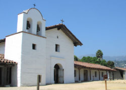
Presidio of Santa Barbara
The El Presidio Real de Santa Bárbara, also known as the Royal Presidio of Santa Barbara, was a military installation in Santa Barbara, California. It was built by Spain in 1782, with the mission of defending the Second Military District in California...
, one of several military outposts meant to protect the area against foreign interests. While the Presidio was not completed until 1792, Padre Lasuén dedicated the new Mission Santa Barbara
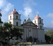
Mission Santa Barbara
In 1840, Alta California and Baja California were removed from the Diocese of Sonora to form the Diocese of Both Californias. Bishop Francisco Garcia Diego y Moreno, OFM, established his cathedra at Mission Santa Barbara, making the chapel the pro-cathedral of the diocese until 1849...
on the feast day of Santa Barbara (December 4, 1786). He chose for his building site the location of a Chumash village on Mission Creek named Tay-nay-án.
Many of the soldiers who came to build and garrison the Presidio had brought their families with them, and after their terms of service ended settled in Santa Barbara. They built their adobes near the Presidio, arranged haphazardly; a Boston journalist described the scatter of these buildings "as though fired from a blunderbuss." Most of Santa Barbara's old families are descended from these early settlers, and many of their names linger in the street and place names, such as Cota, De la Guerra, Gutierriez, Carrillo, and Ortega.
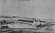
Building the Mission itself continued throughout the rest of the century, along with the work of converting the Indians to Christianity, a task which proved difficult: according to the Mission registers, by 1805, only 185 of the more than 500 Indians in Santa Barbara had been baptized. The burial register shows that 3,997 Indians died between 1787 and 1841, the majority from diseases such as smallpox, to which the natives had no natural immunity. By 1803 the Mission's chapel was finished, and by 1807 a complete village for the Indians had been completed, largely by their own labor. The site of this village is on the Mission grounds along modern-day Constance Street.
On December 21, 1812, one of the largest earthquakes in California history completely destroyed the first Mission along with most of Santa Barbara. With an estimated magnitude of 7.2, and a hypothesized epicenter near Santa Cruz Island, the quake also produced a tsunami which carried water all the way to modern-day Anapamu Street, and carried a ship a half-mile up Refugio Canyon. Following the devastating earthquake, the Mission padres decided to build a larger and more elaborate Mission complex, which is the one that survives to the present day. While the church was ready in 1820, the bell towers were not finished until 1833.
The most serious military threat to Santa Barbara during the Spanish period was not by a colonial power, but by Hippolyte de Bouchard
Hippolyte de Bouchard
Hippolyte de Bouchard, or Hipólito de Bouchard , was a French and Argentine sailor and corsair who fought for Argentina, Chile, and Peru....
, a French privateer working for the Argentine
Argentina
Argentina , officially the Argentine Republic , is the second largest country in South America by land area, after Brazil. It is constituted as a federation of 23 provinces and an autonomous city, Buenos Aires...
government, which was, along with Mexico, attempting to throw off Spanish rule. Bouchard, who was given the task of destroying as many Spanish assets as possible, and in particular the ports in the Americas, possessed two well-armed frigates, which had sufficient armament and crews to destroy any lightly defended towns they encountered. He had done exactly that to Monterey
Monterey, California
The City of Monterey in Monterey County is located on Monterey Bay along the Pacific coast in Central California. Monterey lies at an elevation of 26 feet above sea level. As of the 2010 census, the city population was 27,810. Monterey is of historical importance because it was the capital of...
, the capital of Alta California
Alta California
Alta California was a province and territory in the Viceroyalty of New Spain and later a territory and department in independent Mexico. The territory was created in 1769 out of the northern part of the former province of Las Californias, and consisted of the modern American states of California,...
, shortly before coming to Santa Barbara.
Bouchard landed first at Refugio Canyon, where they pillaged and burned the ranch belonging to the Ortega family, killing the cattle and slitting the throats of the horses. However, after being alerted by messengers from Monterey, the Presidio dispatched a squadron of cavalry, who caught three stragglers from the ill-disciplined raiding party and dragged them back to Santa Barbara in chains. Bouchard sailed the remaining twenty miles (32 km) to Santa Barbara a few days later, anchoring off of present-day Milpas Street, and threatened to shell the town unless his men were returned to him. José de la Guerra y Noriega
José de la Guerra y Noriega
José Antonio de la Guerra y Noriega was a soldier and early settler of California.-Biography:José de la Guerra was born 1779 at Novales, Cantabria, Spain. As a boy he wished to be a friar...
, the commandante of the Presidio, granted his request, but Bouchard did not realize that he had been tricked: the town was not as heavily defended as it had seemed to be; the hundreds of cavalrymen Bouchard had seen through his spyglass were but the same few dozen riding in large circles, stopping and changing costumes each time they passed behind a patch of heavy brush. Although Bouchard had recently destroyed Monterey, he departed without destroying the town.
Mexican period
Mexican War of Independence
The Mexican War of Independence was an armed conflict between the people of Mexico and the Spanish colonial authorities which started on 16 September 1810. The movement, which became known as the Mexican War of Independence, was led by Mexican-born Spaniards, Mestizos and Amerindians who sought...
. Santa Barbara, along with the rest of Alta California
Alta California
Alta California was a province and territory in the Viceroyalty of New Spain and later a territory and department in independent Mexico. The territory was created in 1769 out of the northern part of the former province of Las Californias, and consisted of the modern American states of California,...
, became a territory of independent Mexico
Mexico
The United Mexican States , commonly known as Mexico , is a federal constitutional republic in North America. It is bordered on the north by the United States; on the south and west by the Pacific Ocean; on the southeast by Guatemala, Belize, and the Caribbean Sea; and on the east by the Gulf of...
. One of the earliest notable events in the Mexican period in Santa Barbara was the February 1824 Indian rebellion. The Indians especially resented the poor and scapegoating treatment given them by the soldiers stationed at the Presidio, who were resentful of being unpaid by the new government. The rebellion, incited by the more warlike Yokut—Tulares, inland relations of the Chumash, began at Mission Santa Inés
Mission Santa Inés
Mission Santa Inés was founded on September 17, 1804 by Father Estévan Tapís, who had succeeded Father Fermín Lasuén as President of the California mission chain...
, near present-day Solvang
Solvang, California
Solvang is a city in Santa Barbara County, California, United States. It is one of the communities that make up the Santa Ynez Valley. The population was 5,245 at the 2010 census, down from 5,332 at the 2000 census...
on the other side of the Santa Ynez Mountains
Santa Ynez Mountains
The Santa Ynez Mountains are a portion of the Transverse Ranges, part of the Pacific Coast Ranges of the west coast of North America, and are one of the northernmost mountain ranges in Southern California.-Geography:...
, and quickly spread to Mission La Purísima Concepción
Mission La Purísima Concepción
Mission La Purisima Concepción, or La Purisima Mission, with the original Spanish name being La Misión de La Purísima Concepción de la Santísima Virgen María, was founded on the Feast Day of the Immaculate Conception of the Blessed Virgin on December 8, 1787...
. In Santa Barbara, the Indians seized control of the buildings of the Mission complex, but immediately the buildings were surrounded by Presidio soldiers, since the Presidio was little more than a mile away. Overnight the Indians were able to make a getaway north into Mission Canyon
Mission Canyon, California
Mission Canyon is a census-designated place and an unincorporated suburb of Santa Barbara, California, in Santa Barbara County, United States. The population was 2,381 at the 2010 census, down from 2,610 at the 2000 census....
and then over the mountains, where they eventually linked up with other unsubdued groups of Native Americans in the southern San Joaquin Valley
San Joaquin Valley
The San Joaquin Valley is the area of the Central Valley of California that lies south of the Sacramento – San Joaquin River Delta in Stockton...
. After a battle near San Emigdio Creek in March, and a subsequent three month pursuit and negotiation, the Indians were recaptured near Buena Vista Lake, and brought back to Santa Barbara.
During the Mexican period, the government shifted from military to civilian, with the first city council forming in 1826. During this period Alta California opened to trade with the United States and other areas for the first time, and exporting became important to the local economy. Some commodities exported included tallow and hides trade, both which were carried by California clippers to Boston to the candle- and shoe-making factories in New England, in return for goods purchased by the locals. One of the most famous English-language descriptions of Santa Barbara from this period is by Richard Henry Dana, Jr.
Richard Henry Dana, Jr.
Richard Henry Dana Jr. was an American lawyer and politician from Massachusetts, a descendant of an eminent colonial family who gained renown as the author of the American classic, the memoir Two Years Before the Mast...
, who wrote of the town as a desolate place, at the ends of the earth, in Two Years Before the Mast
Two Years Before the Mast
Two Years Before the Mast is a book by the American author Richard Henry Dana, Jr., published in 1840, having been written after a two-year sea voyage starting in 1834. A film adaptation under the same name was released in 1946.- Background :...
:
By 1833 the process of secularization
Secularization
Secularization is the transformation of a society from close identification with religious values and institutions toward non-religious values and secular institutions...
at the Missions was completed, and the lands and property were given to soldiers, leading Californio
Californio
Californio is a term used to identify a Spanish-speaking Catholic people, regardless of race, born in California before 1848...
s, and occasionally the original Native American
Native Americans in the United States
Native Americans in the United States are the indigenous peoples in North America within the boundaries of the present-day continental United States, parts of Alaska, and the island state of Hawaii. They are composed of numerous, distinct tribes, states, and ethnic groups, many of which survive as...
owners, with most of the Indians becoming Mexican citizens. This had a dramatic effect on the economy and culture, commencing what is called the Rancho Period
Ranchos of California
The Spanish, and later the Méxican government encouraged settlement of territory now known as California by the establishment of large land grants called ranchos, from which the English ranch is derived. Devoted to raising cattle and sheep, the owners of the ranchos attempted to pattern themselves...
in California history, a period which overlapped the end of the Mexican era. Lands formerly owned by the Church were parceled out in land grants to applicants; the Mexican governors of California awarded over 800 separate land grants before the end of Mexican control in 1847. Many local place names derive from these grants, including Dos Pueblos
Rancho Dos Pueblos
Rancho Dos Pueblos was a Mexican land grant in present day Santa Barbara County, California given in 1842 by Governor Juan Alvarado to Nicolas A. Den. The land extended along the Pacific coast to the northwest of the pueblo and Presidio of Santa Barbara, from Goleta Slough west to Dos Pueblos...
, San Marcos
Rancho San Marcos
Rancho San Marcos was a Mexican land grant in present day Santa Barbara County, California given in 1846 by Governor Pio Pico to Nicolas A. Den and Richard S. Den. The grant in the Santa Ynez Valley extended between the San Rafael Mountains and the Santa Ynez River.-History:The former Santa...
, Nuestra Señora del Refugio, El Rincon
Rancho El Rincon (Arellanes)
Rancho El Rincon was a Mexican land grant in present day Santa Barbara County and Ventura County, California given in 1835 by Governor José Figueroa to Teodoro Arellanes. "Rincon" means "corner" in Spanish...
, Las Positas y la Calera
Rancho Las Positas y La Calera
Rancho Las Positas y La Calera was a Mexican land grant in present day Santa Barbara County, California. The grant consisted of two parts:- "La Calera" given in 1843 by Governor Manuel Micheltorena to Narciso Fabregat, and "Las Positas" given in 1846 by Governor Pío Pico to Thomas M. Robbins...
, Lompoc
Rancho Lompoc
Rancho Lompoc was a Mexican land grant in present day Santa Barbara County, California given in 1837 by Governor Juan B. Alvarado to Joaquín Carrillo and José Antonio Carrillo...
, Alamos
Rancho Los Alamos
Rancho Los Alamos was a Mexican land grant in present day Santa Barbara County, California given in 1839 by Governor Juan Alvarado to José Antonio de la Guerra, a son of José de la Guerra y Noriega...
, and La Goleta
Rancho La Goleta
Rancho La Goleta was a Mexican land grant in present day Santa Barbara County, California given in 1846 by Governor Pío Pico to Daniel A. Hill. The grant extended along the Pacific coast from today’s Fairview Avenue in present day Goleta, east to Hope Ranch. The grant was adjacent to Rancho...
.
Cattle ranching rapidly expanded, becoming the predominant land use; horsemanship and cattle ownership became the symbols of status, and the society developed quasi-feudal characteristics, in which the largest ranches were almost entirely self-sufficient. The Chumash who previously had served the padres in the Mission system became laborers on the ranches, occupying the lowest rung of the social ladder, with the oldest established families – the Ortegas, De la Guerras, and others – at the top. During this period the town of Santa Barbara grew into a modest, and informally organized collection of pueblos around the central Presidio. A few of these buildings – such as the Covarrubias adobe, on the grounds of the Santa Barbara Historical Society on Santa Barbara Street, which was briefly the location of the capitol of California during the Mexican War – survive to the present day. By the mid-1840s the Mexican period, the population of Santa Barbara had reached approximately 2,500.
Mexican–American War
The end of the Mexican period came quickly for Santa Barbara, but without bloodshed. The United States conquest of CaliforniaConquest of California
The "Conquest of California" or Conquest of Alta California by the United States covers the initial 1846 period of the Mexican-American War in Alta California, the present day state of California, United States...
in the Mexican–American War
Mexican–American War
The Mexican–American War, also known as the First American Intervention, the Mexican War, or the U.S.–Mexican War, was an armed conflict between the United States and Mexico from 1846 to 1848 in the wake of the 1845 U.S...
had broken out in May 1846 over the annexation of Texas; in August, Commodore Robert F. Stockton
Robert F. Stockton
Robert Field Stockton was a United States naval commodore, notable in the capture of California during the Mexican-American War. He was a naval innovator and an early advocate for a propeller-driven, steam-powered navy. Stockton was from a notable political family and also served as a U.S...
anchored a warship in Santa Barbara harbor and deployed a contingent of ten Marines to occupy the town. They proceeded to the Presidio where they ran the Stars and Stripes over the city for the first time; not long afterwards, seeing the town was peaceful, they left, being replaced later by ten cavalrymen from John C. Frémont
John C. Frémont
John Charles Frémont , was an American military officer, explorer, and the first candidate of the anti-slavery Republican Party for the office of President of the United States. During the 1840s, that era's penny press accorded Frémont the sobriquet The Pathfinder...
's army. However, a contingent of a hundred Mexican cavalrymen sent by General José María Flores
José Mariá Flores
General José María Flores was an officer in the Mexican Army and was a member of la otra banda. He was appointed Governor and Comandante General pro tem of Alta California from 1846 to 1847.-Mexican-America War:...
came and chased them out. The outnumbered cavalrymen, rather than surrender, fled on foot up into Mission Canyon, and fortified a rocky ridge below La Cumbre Peak
La Cumbre Peak
La Cumbre Peak is a 3,995 foot peak in the Santa Ynez Mountains north of Santa Barbara, California. Made up of boulders and slabs of the Matilija Sandstone amid groves of pine trees, it is the highest summit near to the city...
, resisting the calls to surrender by their pursuers. When the Mexican force set fire to the chaparral, the Americans clambered over the mountain ridge overnight, escaping north and eventually reaching Monterey, where they joined forces again with Frémont.
The culminating event of the Mexican–American War
Mexican–American War
The Mexican–American War, also known as the First American Intervention, the Mexican War, or the U.S.–Mexican War, was an armed conflict between the United States and Mexico from 1846 to 1848 in the wake of the 1845 U.S...
for Santa Barbara was Frémont's return, over the surprise route of San Marcos Pass
San Marcos Pass
San Marcos Pass is a mountain pass in the Santa Ynez Mountains in California.It is traversed by State Route 154. The pass connects Los Olivos and the Santa Ynez Valley with Santa Barbara, California...
, which at the time was little more than a trail. On the night of December 24, 1846, during a torrential rainstorm, he led his California Battalion over the mountains. In spite of losing many of his horses, mules, and cannon to the treacherous and muddy slopes – and not a one to enemy fire – he reached the foothills on the other side in the vicinity of present-day Tucker's Grove, spent the next several days regrouping, and then marched in to Santa Barbara to capture the Presidio. He encountered no resistance: all men interested in fighting had left for Los Angeles to join the forces headed by Flores and Andrés Pico
Andrés Pico
Andrés Pico was a Californio who became a successful rancher, served as a military commander during the Mexican-American War; and was elected to the state assembly and senate after California became a state, when he was also commissioned as a brigadier general in the state militia.-Early...
which had assembled to defend that city. On January 3 Frémont headed south, skirting the cliffs of the Rincon at low tide (no road existed then), arriving in Los Angeles ten days later. The Treaty of Cahuenga
Treaty of Cahuenga
The Treaty of Cahuenga, also called the "Capitulation of Cahuenga," ended the fighting of the Mexican-American War in Alta California in 1847. It was not a formal treaty between nations but an informal agreement between rival military forces in which the Californios gave up fighting...
, signed on January 13, 1847, ended the war in California. After the Treaty of Guadalupe Hidalgo
Treaty of Guadalupe Hidalgo
The Treaty of Guadalupe Hidalgo is the peace treaty, largely dictated by the United States to the interim government of a militarily occupied Mexico City, that ended the Mexican-American War on February 2, 1848...
, signed a year later, Santa Barbara formally became part of the United States.
U.S. annexation; Gold Rush; Haley; Civil War
Change came quickly after the end of the war. Gold was found at Sutter's Mill in the Sierra foothills, and hordes of gold-seekers flooded into California from the eastern United States, and other places in the world, to become rich. Few did, but Santa Barbara began to attract settlers, as newcomers discovered the charms of the place, including that almost anything planted would grow there. In 1850 California became the 31st state, and immediately after its establishment both Santa Barbara City and County came into being. By 1850 the area was still sparsely populated, with the census showing only 1,185 people for the entire county, but that number doubled in ten years.Some of the changes that occurred involved administration, communications, construction, urban layout, and transportation. On April 9, 1850, Santa Barbara incorporated as a city, and formed an official town council. The appearance of the town began to change as well. Settlers coming from the east wanted dwellings made from wood, rather than the sensible adobe built by the Spanish and Mexican residents; to build them they needed to import wood from distant Oregon, as the local oak trees were not suitable for lumber. This was one of several pressures that resulted in the development of the port.
Another consequence of the American takeover was the creation of the street grid, which replaced the previous haphazard jumble of dwellings and irregular paths. Its execution, the disastrously bungled survey of 1851 by Salisbury Haley, is a notorious event in local history. Haley's survey chains were broken in places, and held together with oxhide, a material that expanded on damp mornings and contracted in the afternoon sun; since his chains varied in length depending on the time of day he used them, most of his measurements were off, accumulating errors of as much as 45 feet (13.7 m) out of true by the time he had crossed the city. Haley had been ordered to create neat square city blocks exactly 450 feet (137.2 m) on a side: a subsequent corrective survey established that he had actually created blocks ranging from 457 to 464 feet (141.4 m) on a side. The lot misalignments and street grid problems caused by Haley persist to the present day. Kinks in Mission Street at De La Vina, and De La Guerra at Santa Barbara Street are two of the awkward places well-known to city commuters which were resulted from Haley's unfortunate measurements. In addition, it was Haley who decided to lay out the street grid at an angle of approximately 48 degrees from north, with State Street approximately midway between the Mesa and the Riviera, paralleling both hills, an orientation that confuses both residents and visitors. Downtown's Haley Street, named after him, is ironically one of the streets which did not need a dog-leg to compensate for his variable-length chain.
Another change that accompanied the transformation of Santa Barbara from a small village to a significant town was the founding of the first newspaper, the Santa Barbara Gazette, in 1855. The newspaper was half in English and half in Spanish, since the population, not all of whom were bilingual, was split between the two languages. English gradually supplanted Spanish as the language of daily life. Although minutes of the newly formed City Council were kept in English by 1852, Spanish remained the language used for public records until 1870.
Lynching
Lynching is an extrajudicial execution carried out by a mob, often by hanging, but also by burning at the stake or shooting, in order to punish an alleged transgressor, or to intimidate, control, or otherwise manipulate a population of people. It is related to other means of social control that...
s. Outlaws such as Joaquin Murrieta
Joaquin Murrieta
Joaquin Carrillo Murrieta , also called the Mexican or Chilean Robin Hood or the Robin Hood of El Dorado, was a semi-legendary figure in California during the California Gold Rush of the 1850s...
(the Zorro
Zorro
Zorro is a fictional character created in 1919 by New York-based pulp writer Johnston McCulley. The character has been featured in numerous books, films, television series, and other media....
of Hollywood legend, but likely a composite of several different bandits) preyed on travelers on the roadways, and even on citizens in town. The confrontation with the gang led by Jack Powers
Jack Powers
Jack Powers was an Irish-American gambler, outlaw, highway-robber, gang leader, and murderer in southern and central California during the Gold Rush era...
at the "Battle of Arroyo Burro" in 1853, in which he intimidated and drove away a posse of approximately 200 citizens, was one of the most dramatic incidents of the period. Powers was not thrown out of town until a band of angry and well-armed vigilantes from San Luis Obispo rode to Santa Barbara to get rid of him (he eventually came to a bloody end, murdered and hurled into a den of hungry wild boars in the Mexican state of Sonora
Sonora
Sonora officially Estado Libre y Soberano de Sonora is one of the 31 states which, with the Federal District, comprise the 32 Federal Entities of Mexico. It is divided into 72 municipalities; the capital city is Hermosillo....
). His downfall coincided with the return of law and order after a period in which Santa Barbara was the rowdiest and most dangerous town between Los Angeles and San Francisco.
In 1859, Richard Henry Dana returned, 24 years after his first visit as a 20-year-old sailor, and described the changes in the town:
In that same year, 1859, Santa Barbara recorded the highest temperature ever noted on the North American continent, 133 °F (56.1 °C), a record which was to stand until Death Valley topped it by one degree in 1913. The U.S. Coast Survey wrote that birds dropped dead in midair, cattle died in the fields, and fruit dropped, scorched, from trees; the town's inhabitants fled to the safety of their adobe buildings, which insulated them from the freak superheated northwest simoon wind, an event which has not occurred since. In the immediately following years, two other weather events had a significant effect on the course of development in Santa Barbara: catastrophic floods during the winter of 1861-62, during which the Goleta Slough, formerly open to deep-water vessels, completely silted up, becoming the marsh it remains to the present day; and the disastrous drought of 1863, which forever ended the Rancho era as the value of rangeland collapsed, cattle died or were sold off, and the large ranches were broken down and sold in smaller parcels for development.
Victorian period
The town continued to grow, and slowly ended its isolation after the American Civil WarAmerican Civil War
The American Civil War was a civil war fought in the United States of America. In response to the election of Abraham Lincoln as President of the United States, 11 southern slave states declared their secession from the United States and formed the Confederate States of America ; the other 25...
. The war itself had little effect on Santa Barbara. One troop of cavalry organized to join the Union cause, but never saw action against Confederate forces; they served briefly and bloodlessly in Arizona versus Apache
Apache
Apache is the collective term for several culturally related groups of Native Americans in the United States originally from the Southwest United States. These indigenous peoples of North America speak a Southern Athabaskan language, which is related linguistically to the languages of Athabaskan...
raids. In 1869, the first coeducational preparatory school in southern California, Santa Barbara College, opened at State and Anapamu Streets. Improvements in the harbor included the building of Stearns Wharf in 1872, which increased the commercial capacity of the port; formerly, ships had to anchor several miles offshore, and load and unload their cargoes by rowing small boats to the shore. In that same year, Jose Lobero built an opera house (at the current site of the Lobero Theatre), State Street was paved, and gas lamps were lit downtown.
Southern Pacific Railroad
The Southern Pacific Transportation Company , earlier Southern Pacific Railroad and Southern Pacific Company, and usually simply called the Southern Pacific or Espee, was an American railroad....
to write about Santa Barbara to draw easterners to the town, was largely responsible for the boom in the tourism industry that commenced in the 1870s, and which would eventually lead to Santa Barbara becoming a world-famous resort. He praised Santa Barbara as the "pleasantest" spot in California, and particularly delightful for those suffering health ills; his book resulted in steamships full of travelers, many of whom came to stay. The luxurious and instantly famous Arlington Hotel, built in 1874 (and destroyed by fire in 1909), housed many of them.
The isolation of Santa Barbara ended in stages. The building of Stearns Wharf allowed easy access by steamboat
Steamboat
A steamboat or steamship, sometimes called a steamer, is a ship in which the primary method of propulsion is steam power, typically driving propellers or paddlewheels...
; in 1887, the railroad to Los Angeles was completed; and in 1901, the railroad was put through to San Francisco. Santa Barbara was finally accessible both by land and sea. The day that the first train arrived from San Francisco was also the last day that the stagecoach bumped over dusty San Marcos Pass. These new connections made possible Santa Barbara's development into the resort destination it has remained ever since. Within the city, the first electric streetcar line opened in 1896, as the demand for transportation increased. By 1900, the population had reached 6,587, doubling in twenty years.
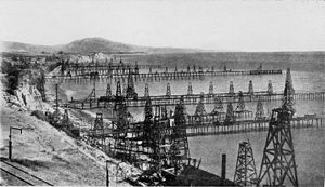
The discovery of oil changed the local economy as well as the landscape. While the black gooey stuff had long been known from natural oil seeps, and was used as a roof sealant during the building of the Mission, its value as a fuel did not become widely known until the late 19th century. In the 1890s, the large Summerland Oil Field
Summerland Oil Field
The Summerland Oil Field is an inactive oil field in Santa Barbara County, California, about four miles east of the city of Santa Barbara, within and next to the unincorporated community of Summerland...
was found and began to be developed. Summerland was the site of the world's first offshore oil well. While most of the oil had been pumped out by 1910, derricks remained on the beach in Summerland
Summerland, California
Summerland is a census-designated place in Santa Barbara County, California, United States. The population was 1,448 at the 2010 census, down from 1,545 at the 2000 census.The town includes a school and a Presbyterian Church...
into the 1920s, and the field remained partially productive until 1940.
Early 20th century to World War II
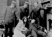
Lon Chaney, Sr.
Lon Chaney , nicknamed "The Man of a Thousand Faces," was an American actor during the age of silent films. He was one of the most versatile and powerful actors of early cinema...
and Victor Fleming
Victor Fleming
Victor Lonzo Fleming was an American film director, cinematographer, and producer. His most popular films were The Wizard of Oz , and Gone with the Wind , for which he won an Academy Award for Best Director.-Life and career:Fleming was born in La Canada, California, the son of Elizabeth Evaleen ...
were among the famous actors featured. In 1911, before the Flying A had become the predominant studio in the area, there were 13 separate film companies in Santa Barbara. The local film era ended in 1922 when the studios moved south, needing the resources of a larger city.
During this period, the city continued to grow, and at an even faster pace. By 1920, the population had reached 19,441, tripling in twenty years. The completion of the water tunnel under the mountains to newly completed Gibraltar Reservoir on the Santa Ynez River
Santa Ynez River
The Santa Ynez River is one of the largest rivers on the Central Coast of California. It is long, flowing from east to west through the Santa Ynez Valley, reaching the Pacific Ocean at Surf, near Vandenberg Air Force Base and the city of Lompoc....
relieved the water shortages for a time. Also during the teens, a movement for city beautification commenced, led by Bernard Hoffman and later by Pearl Chase; their idea was to unify the city's architecture around a Spanish Colonial style, harmonious with the Mission and surviving pueblos. Many of the buildings from the late 19th century were, to their eyes and the eyes of many citizens, ugly, dilapidated, and no different from those in dozens of other run-down western towns. The Lobero Theatre, built on the site of the original Lobero Opera House in 1924, was an example of the architectural style they promoted, as was the first part of the Santa Barbara Natural History Museum.
1925 earthquake
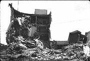
1906 San Francisco earthquake
The San Francisco earthquake of 1906 was a major earthquake that struck San Francisco, California, and the coast of Northern California at 5:12 a.m. on Wednesday, April 18, 1906. The most widely accepted estimate for the magnitude of the earthquake is a moment magnitude of 7.9; however, other...
, occurred on June 29, 1925, converting much of the town to heaps of rubble. While the quake's epicenter was centered on an undetermined fault offshore, most of the damage came about due to two strong aftershocks which occurred onshore and five minutes apart. The intensity on the Modified Mercalli scale
Mercalli intensity scale
The Mercalli intensity scale is a seismic scale used for measuring the intensity of an earthquake. It measures the effects of an earthquake, and is distinct from the moment magnitude M_w usually reported for an earthquake , which is a measure of the energy released...
was determined to be VIII for the coast from Goleta, through Santa Barbara, and to Carpinteria.
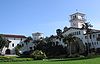
The low death toll (13 or 14) is credited to its early hour, 6:23 a.m., before most people were in the streets at risk from falling masonry. A fire which broke out after the earthquake destroyed more of the town, but was contained by a company of U.S. Marines who had arrived immediately to help maintain order. The earthquake, coinciding with the movement for architectural reform, is credited with giving the town its unified Spanish character; during the rebuilding, Hoffman and Chase pushed for new structures to be in a Spanish style. The most famous of these was the Spanish-Moorish style County Courthouse
Santa Barbara County Courthouse
The Santa Barbara County Courthouse is located at 1100 Anacapa Street, Santa Barbara, California. Designed by William Mooser III and completed in 1929, the Spanish Colonial Revival style building replaced the smaller Greek Revival courthouse of the same location...
, completed in 1929, "the loveliest in the United States." One of the only voices opposing the unification of architectural style was newspaper publisher and future Senator Thomas Storke, who later changed his mind, saying that his former opposition was due to his belief that such compulsion infringed on the constitutional rights of property owners. Storke in 1932 created the city's main newspaper for the next 74 years, the News-Press, by winning a libel suit against his rival Reginald Fernald, and absorbing that publisher's Morning Press into his Daily News.
In 1928, oil was found at the Ellwood Oil Field
Ellwood Oil Field
Ellwood Oil Field and South Ellwood Offshore Oil Field are a pair of adjacent, partially active oil fields adjoining the city of Goleta, California, about twelve miles west of Santa Barbara, largely in the Santa Barbara Channel...
on the other side of Santa Barbara, and development of this new and rich pool was fast: the peak production in 1930, only two years later, was 14.6 Moilbbl of oil. As at the Summerland Oil Field, derricks went along piers into the ocean, and the cliffs were dotted with storage tanks. Some of this development remains to the present day, with one active wastewater disposal well and several large storage tanks, owned by Venoco, Inc., adjacent to the Ellwood Open Space. In 1929, as part of the wild burst of oil-drilling activity following on the Ellwood discovery, the Mesa Oil Field
Mesa Oil Field
The Mesa Oil Field is an abandoned oil field entirely within the city limits of Santa Barbara, California, in the United States. Discovered in 1929, it was quickly developed and quickly declined, as it proved to be but a relatively small accumulation of oil in a single geologic formation...
was discovered within the city limits. Centered just south of Cliff Drive near the intersection with Santa Cruz Boulevard, the field sprouted over 100 oil derricks in the early 1930s, occasioning the city's first anti-oil protest, but a local ordinance had already been enacted allowing such development. The field’s failure in the late 1930s—it proved to be smaller than initially thought—allowed residential development to continue on the Mesa, although the field was not formally abandoned until 1976.
University of California, Santa Barbara
The University of California, Santa Barbara, commonly known as UCSB or UC Santa Barbara, is a public research university and one of the 10 general campuses of the University of California system. The main campus is located on a site in Goleta, California, from Santa Barbara and northwest of Los...
campus. The military filled in the Goleta Slough in order to expand the adjacent airport; the U.S. Navy took over the harbor area; and north of Point Conception
Point Conception
Point Conception is a headland along the Pacific coast of U.S. state of California, located in southwestern Santa Barbara County. It is the point where the Santa Barbara Channel meets the Pacific Ocean, and as the corner between the mostly north-south trending portion of coast to the north and the...
the Army created Camp Cook, which was later to become Vandenberg Air Force Base
Vandenberg Air Force Base
Vandenberg Air Force Base is a United States Air Force Base, located approximately northwest of Lompoc, California. It is under the jurisdiction of the 30th Space Wing, Air Force Space Command ....
. On February 23, 1942, not long after the outbreak of war in the Pacific, a Japanese submarine emerged from the ocean and lobbed about 25 shells at the Ellwood Oil Field facilities, one of only two direct attacks on the U.S. mainland
Attacks on North America during World War II
The American Theater of World War II was a minor area of operations mainly due to the continent's geographical separation from the central theaters of conflict in Europe and Asia...
during the entire war, and the first such attack since the War of 1812. Although the gunners were terrible marksmen, and only caused about $500 damage to a catwalk, panic was immediate. Many Santa Barbara residents fled, and land values plummeted to historic lows. Only one week after the attack, on March 2, military authorities issued Public Proclamation No. 1, which began the long internment of Japanese during the war, and approximately 700 people of Japanese ancestry assembled on Cabrillo Boulevard to be taken to Manzanar
Manzanar
Manzanar is most widely known as the site of one of ten camps where over 110,000 Japanese Americans were imprisoned during World War II. Located at the foot of the Sierra Nevada in California's Owens Valley between the towns of Lone Pine to the south and Independence to the north, it is...
.
After World War II
After the war ended, many people who had seen Santa Barbara during the war came back to stay. The population grew by 10,000 by 1950, in just five years. During this time the University of California took over the blufftop Marine camp, turning it into a modern university. The burst of growth brought traffic, housing, and water problems, which led to improvements in the transportation system, such as the building of Highway 101 through town; tracts of low-cost housing, especially on the Mesa, where oil derricks were removed and replaced by houses; and the building of Lake Cachuma reservoir on the other side of the mountains, along with another water tunnel to bring its water to thirsty residents. During this period, the city selectively recruited businesses to relocate there, choosing clean industries such as aerospace and technology in preference to the oil industry which had already marred many local landscapes with abandoned wells and sumps.The oil industry moved most of its local operations offshore during the 1950s and 1960s. In 1947, offshore leases were approved by the federal government, and seismic exploration of the Channel took place in the 1950s, even though fishermen complained that the underwater explosions were killing fish. The first of the huge black fifteen-story oil platforms, a feature of the seascape south of Santa Barbara for fifty years, went up in 1958. During the period, Stearns Wharf was the main connection for oil services going out to the platforms.
Making the relationship between Santa Barbara and the oil industry even worse was the disaster of January 28, 1969
1969 Santa Barbara oil spill
The Santa Barbara oil spill occurred in January and February 1969 in the Santa Barbara Channel, near the city of Santa Barbara in Southern California. It was the largest oil spill in United States waters at the time, and now ranks third after the 2010 Deepwater Horizon and 1989 Exxon Valdez spills...
, one of the formative events in the modern environmental movement. A blowout on an offshore oil well at the Dos Cuadras Offshore Oil Field
Dos Cuadras Offshore Oil Field
The Dos Cuadras Offshore Oil Field is a large oil and gas field underneath the Santa Barbara Channel about eight miles southeast of Santa Barbara, California. Discovered in 1968, and with a cumulative production of over 260 million barrels of oil, it is the 24th-largest oil field within California...
spewed between 80000 and 100000 bbl (12,719 and 15,898.7 m3) of oil, producing an immense oil slick which spread over hundreds of square miles of ocean in the Santa Barbara Channel, contaminating shorelines, killing wildlife, ruining the tourist industry, and appearing on television screens worldwide. The anti-oil group "GOO" (Get Oil Out) formed shortly after the spill, and oil drilling has been a sensitive issue in the area ever since. Wider consequences of the spill included the 1970 passage of both the National Environmental Policy Act
National Environmental Policy Act
The National Environmental Policy Act is a United States environmental law that established a U.S. national policy promoting the enhancement of the environment and also established the President's Council on Environmental Quality ....
and the California Environmental Quality Act
California Environmental Quality Act
The California Environmental Quality Act is a California statute passed in 1970, shortly after the United States federal government passed the National Environmental Policy Act , to institute a statewide policy of environmental protection...
, laws which require assessment of potential environmental impacts of projects before they begin.
Chumash Painted Cave State Historic Park, California
Chumash Painted Cave State Historic Park is a unit in the state park system of California, USA, preserving a small sandstone cave adorned with rock art attributed to the Chumash people. Adjoining the small community of Painted Cave, the site is located about north of California State Route 154...
Fire, which incinerated over 500 homes in just several hours during an intense Sundowner wind event, crossing over the freeway to Hope Ranch
Hope Ranch, California
Hope Ranch is an unincorporated suburb of Santa Barbara, California, located in Santa Barbara County. As of the 2000 census, the area had an approximate population of 2,200. The ZIP codes are 93105 and 93110, and the community is in area code 805.-History:...
, and causing over a quarter billion dollars in damage.
The population center of Santa Barbara moved west during the period, with the buildout of the region west of the De La Vina/State intersection, including the San Roque neighborhood, Hope Ranch Annex, and later the Goleta Valley. As a result, the citrus groves which formerly stood in the region were cut down and replaced by housing and commercial districts. Regional shopping centers such as Loreto Plaza, Five Points, and La Cumbre Plaza developed during this period. Between 1960 and 1970, the population of the Goleta Valley rose from only 19,016 to 60,184.
By the mid-1970s, forces opposing uncontrolled growth had become stronger than those favoring development. On April 8, 1975, the City Council passed a resolution to limit the city's population to 85,000 through zoning. In order to limit growth in adjacent areas, such as Goleta, it was standard to deny water meters to developments which had been approved by the County Board of Supervisors, effectively shutting off growth. The city and immediately adjacent areas stopped their fast growth, but housing prices rose sharply.
When voters approved connection to state water supplies in 1991, parts of the city, especially outlying areas, resumed growth, but more slowly than during the boom period of the 1950s and 1960s. While the slow growth preserved the quality of life for most residents and prevented the urban sprawl notorious in the Los Angeles basin, housing in the Santa Barbara area was in short supply, and prices soared: in 2006, only six percent of residents could afford a median-value house. As a result, many people who work in Santa Barbara commute from adjacent, more affordable areas, such as Santa Maria, Lompoc, and Ventura. The resultant traffic on incoming arteries, particularly the stretch of Highway 101 between Ventura and Santa Barbara, is another problem being addressed by long-range planners.
See also
- Category: Ranchos of Santa Barbara County, California