

History of New York City transportation
Encyclopedia
The History of the New York City Transportation System ranges from strong Dutch
authority in the 17th century, expansionism during the industrial era in the 19th century and half of the 20th century, to outright cronyism
during the failures of the Robert Moses
era. The shape of the city's transportation system changed as city did, and the result is an impressive modern-day system of industrial-era infrastructure.
people in Pre-Dutch New York, according to Burrows, et al. This route, part of which is present-day Broadway
, ran from the Battery
, through the East Side
, and exited out of what was the northernmost point of Manhattan, in present-day Marble Hill
. Broadway was not the only former Lenape trail route; Jamaica Avenue
, which connects the present-day boroughs of Brooklyn
and Queens
, runs along a former trail through Jamaica Pass. According to Homberger, present-day Lafayette Street, Park Row, and St. Nicholas Avenue
also follow former Lenape routes. According to Burrow, et al., the Dutch
had decided that that Lenape trail which ran the length of Manhattan, or present-day Broadway, would be called the Heere Wegh. The first paved street in New York was authorized by Petrus Stuyvesant (Peter Stuyvesant) in 1658, to be constructed by the inhabitants of Brouwer Street (present-day Stone Street
).
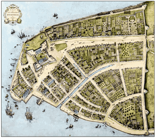 The early Dutch city of Nieuw Amsterdam (New Amsterdam) took full advantage of the rivers which surrounded the city, in some manner a foreshadowing of the empire that New York's shipping industry would establish two centuries later. According to the Castello Plan, multiple canal
s and waterways were built, including a very early canal on the present-day Broad Street
, which was called the Heere Gracht. According to Burrows, et al., a municipal pier was built on what is now Moore Street, on the East River
. The first regional transportation that was built out of Nieuw Amsterdam was a “wagon-road” that linked to Nieuw Haarlem (Harlem
). It was built in 1658 to encourage development of that town, by order of Petrus Stuyvesant, who saw, accurately, that Nieuw Haarlem could provide an important measure of defense for Nieuw Amsterdam.
.
As new streets were laid out beyond Wall Street, the grid became more regular. The river areas being more useful, their streets were first, with streets parallel and perpendicular to their particular river. Later 18th century streets in the middle of the island were even more regular, with city blocks longer in the approximately north/south direction than east/west. By the early 19th century, urban growth had reached approximately the line of the modern Houston Street, and farther in Greenwich Village
. Due to expanding world trade, growth was accelerating, and a commission created a more comprehensive street plan for the remainder of the island.
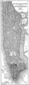 New York adopted a visionary proposal to develop Manhattan north of 14th Street
with a regular street grid
, according to "The Commissioners' Plan of 1811
." This would fundamentally alter the city aesthetically, economically, and geographically. The economic logic underlying the plan - which called for twelve numbered avenues running approximately north and south, and 155 orthogonal cross streets - was that the grid's regularity would provide an efficient means to develop new real estate property and would promote commerce.
Into the middle 19th century most streets remained unpaved, but tracks allowed smooth public transport by horse cars which were eventually electrified as trolleys. The 1854 Jennings streetcar case
abolished racial discrimination in public transit.
's steamboat monopoly. Steamboats provided rapid, reliable connections from New York Harbor
to other Hudson River and coastal ports, and later local steam ferries allowed commuters to live far from their workplaces. The completion in 1825 of the upstate Erie Canal
, spanning the Hudson River
and Lake Erie
, made New York the most important connection between Europe and the American interior. The Gowanus Canal
and other works were built to handle the increased traffic, all suitable existing shorelines having already been lined with docks. The Morris Canal
and Delaware and Raritan Canal
were parts of the extensive system of new infrastructure serving the city with coal and other commodities. The canal age, however, gave way to a railway age.
Steam railroad
s, started in places less generously endowed with waterways, soon reached New York and became a tool of the rivalry among port cities. New York with its New York Central Railroad
came out on top, ensuring the city's continued dominance of the international trade of the interior of the United States. As the West and East sides of Manhattan became more populated, local railroads were elevated or depressed to escape road traffic, and the intercity railroads abandoned their Downtown Manhattan stations on Chambers Street
and elsewhere. Soot and an occasional shower of flaming embers from overhead steam locomotives eventually came to be regarded as a nuisance, and the railroads were converted to electric operation
. A competitive network of plank road
s and surface and elevated railroads sprang up to connect and urbanize Long Island, especially the western parts.
New Yorks' ports continued to grow rapidly during and after the Second Industrial Revolution
, making the city America's mouth, sucking in manufactured goods and immigrants and spewing forth grains and other raw materials to the developed countries. By the mid 19th century, thanks in part to the introduction of oceanic steamships
, more passengers and products came through the Port of New York than all other harbors in the country combined. Conversion to steam brought a large fleet of distinctive New York tugboats
.
Designed by John Roebling, the Brooklyn Bridge
was the first link between Manhattan and the land mass of Long Island. It was notable for size, magnificence and commercial importance. The main span of 1,596' 6" was the longest span of any bridge in the world when it was completed in 1883 – a period of time that firmly established the concept of municipal consolidation among the outlying cities and suburbs into what eventually became the City of Greater New York
. The Williamsburg Bridge
and Manhattan Bridge
completed the trio of architecturally-notable lower East River
crossings in the early 20th century. These and other great bridges carried trolley car
s, whose tracks and electrical wires had already spread through the metropolitan area, creating sprawling streetcar suburbs miles away from the inner city
. Bridges after 1920, being for road vehicles only, had no tracks.
 Streetcars found steam power impractical, and more often progressed directly from horse power to electricity. Suburban electrification involved true trolley cars, but the required overhead wires were forbidden in New York (Manhattan). Traffic congestion
and the high cost of conduit current collection
impeded streetcar development there.
New York's waterways, so useful in establishing its commerce and power, became obstacles to railroads. Freight cars had to be carried across the harbor by car float
s, contributing to harbor traffic already made heavy when many of the great new ocean steamships of the day must be served by lightering
due to insufficient dock slips large enough to accommodate them. The Harlem River
being not so difficult, three railroads with service to the north agreed to build a common Grand Central Terminal
, but disagreement among New Jersey railroad companies foiled efforts to organize a great new rail bridge across the Hudson, so the Pennsylvania Railroad
, with its newly acquired Long Island Rail Road
subsidiary, built the New York Tunnel Extension for its new Pennsylvania Station, New York. Passengers of the other companies changed to the Pennsylvania, or continued to cross the Hudson by ferries and the Hudson Tubes.
The Gowanus Canal being too small to handle late 19th century barges, Newtown Creek
was similarly canalized, serving among other customers the newly translocated gas works of the newly amalgamated Brooklyn Union Gas company on the Whale Creek tributary. Refineries and petrochemical factories followed in later decades, greatly intensifying the industrialization of Greenpoint, Bushwick, Maspeth and other outlying former villages in the newly amalgamated City of Greater New York
. Greenpoint remained a center of the fuel trade beyond the 20th century.
 Workaday purposes were not the only ones pursued on the waters. Mark Twain's Innocents Abroad
recounts one of the first cruise ship
voyages out of Brooklyn in the 1860s for rich people, while the General Slocum
disaster points out the late 19th and early 20th century habit of organizing day excursions for humbler folk. Some trips went to amusement parks or other attractions, and some merely to a dock with a footpath to a meadow for dancing, picnicking and other pleasures made more pleasurable by absence from the hectic, noisy city. Day-tripper
s visited the Great Falls
of the Passaic River
and other tourist attractions by railroad and sometimes by organized bicycle tours. Hudson River Day Line was the last company doing regularly scheduled day trips from West 42d Street; they went out of business in the 1970s.
 New York was not the first to develop rapid transit in the United States, but soon caught up. Elevated trains, after a modest introduction on 9th Avenue
, spread in the 1880s, and late in the century parts of some trolley lines were placed underground. In 1904, the first subway line
became operational.
to handle the ever-growing traffic of oceanic passenger steamships, which was later called Chelsea Piers
.
John D. Hertz
started the Yellow Cab Company
in 1915, which operated hireable vehicles in a number of cities including New York. Hertz painted his cabs yellow after he had read a study that identified yellow as being the most visible color from a long distance. In 1967, New York City ordered all "medallion taxis" be painted yellow.
From the late 1910s to the early 1930s, Mayor John Francis Hylan authorized a system of "emergency bus lines" managed by the Department of Plant and Structures. These were eventually ruled illegal by the courts, and those that continued to operate obtained franchises from the city.
The increased use of private automobile
s greatly affected all transportation projects built more or less after 1930. In 1927, the Holland Tunnel
, built under the Hudson River, was the first mechanically ventilated vehicular tunnel in the world. The Lincoln and Holland tunnels were built instead of bridges to allow free passage of large passenger and cargo ships in the port, which were still critical for New York City's industry through the early- to mid-20th century. Other 20th century bridges and tunnels crossed the East River, and the George Washington Bridge
was higher up the Hudson.
Mayor Fiorello H. La Guardia presided over the construction of the Independent Subway System
started by his predecessors, and promoted an airport in Brooklyn and two larger ones in Queens. The Queens airports grew and prospered in later decades, but construction of new subways came to a virtual standstill after the 1950s, proposed expansions being first deferred and then scaled back.
Mayor La Guardia appointed a dynamic young Robert Moses
as Commissioner of Parks who, in the West Side Improvement, separated the freight service of the West Side Line (NYCRR)
from street life, to the benefit of both and of parks. Later, Moses extended parkway
s beyond previous limits. After 1950 the federal government's priority shifted to freeways, and Moses applied his usual vigor to that kind of construction.
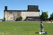
 Hudson River crossings were in the charge of the Port of New York Authority, which also took control of freight piers and built a grain elevator in Red Hook, Brooklyn
and built an Inland Freight Terminal in Lower Manhattan. The Port Authority oversaw the transition of the ocean cargo industry from North River break bulk
operations to containerization
ports, mostly on Newark Bay
, built a Downtown truck terminal on Greenwich Street and Midtown bus terminal
, and took over the financially ailing Hudson Tubes that carried commuters from Hudson and Essex Counties in New Jersey to Manhattan. Plans for a Cross-Harbor Rail Tunnel
to replace the declining car float
operations of the railroads did not come to fruition; instead most land freight traffic converted to trucks. The Port Authority also took over and expanded the major airports owned by the Cities of New York and Newark, New Jersey
.
In 1944, at the height of World War II, the port became the busiest port in world history.
A catalyst for expressways and suburbs, but a nemesis for environmentalists and politicians alike, Robert Moses
was a critical figure in reshaping the very surface of New York, adapting it to the changed methods of transportation after 1930. Beyond designing a series of limited-access parkway
s in four boroughs, which were originally designed to connect New York City to its more rural suburbs, Moses also conceived and established numerous public institutions, large-scale parks, and more. With one exception, Moses had conceptualized and planned every single highway, parkway, expressway, tunnel or other major road in and around New York City; that exception being the East River Drive. All 416 miles of parkway were also designed by Moses. Between 1931 and 1968, seven bridges were built between Manhattan and the surrounding land, including the Triborough Bridge
, and the Bronx-Whitestone Bridge. The Verrazano-Narrows Bridge
connecting Brooklyn
and Staten Island
, was the longest suspension bridge in the world when it was completed in 1964. In addition, Moses was critical in designing several tunnels around the city; these included the Queens Midtown Tunnel
, which was the largest non-Federal project in 1940, and the Brooklyn-Battery Tunnel
in 1950.
In the 1950s, New York's passenger ship docks in the West 20s
were replaced by a modern New York Passenger Ship Terminal
in the West 50s, in time for a great increase of ocean passenger service. The Terminal was extensively renovated in the 1970s, in time for the virtual disappearance of the transatlantic steamship trade. In the 1960s the State took over two financially ailing suburban commuter railroads and merged them, along with the subways and various Moses-era agencies, into what was later named the MTA
.
Netherlands
The Netherlands is a constituent country of the Kingdom of the Netherlands, located mainly in North-West Europe and with several islands in the Caribbean. Mainland Netherlands borders the North Sea to the north and west, Belgium to the south, and Germany to the east, and shares maritime borders...
authority in the 17th century, expansionism during the industrial era in the 19th century and half of the 20th century, to outright cronyism
Cronyism
Cronyism is partiality to long-standing friends, especially by appointing them to positions of authority, regardless of their qualifications. Hence, cronyism is contrary in practice and principle to meritocracy....
during the failures of the Robert Moses
Robert Moses
Robert Moses was the "master builder" of mid-20th century New York City, Long Island, Rockland County, and Westchester County, New York. As the shaper of a modern city, he is sometimes compared to Baron Haussmann of Second Empire Paris, and is one of the most polarizing figures in the history of...
era. The shape of the city's transportation system changed as city did, and the result is an impressive modern-day system of industrial-era infrastructure.
In Dutch Nieuw Amsterdam
Portions of the street that would eventually host eleven subway lines, become slang for the 20th century theater industry, and run through some of the highest priced real estate of the nation, was once a primary route of the LenapeLenape
The Lenape are an Algonquian group of Native Americans of the Northeastern Woodlands. They are also called Delaware Indians. As a result of the American Revolutionary War and later Indian removals from the eastern United States, today the main groups live in Canada, where they are enrolled in the...
people in Pre-Dutch New York, according to Burrows, et al. This route, part of which is present-day Broadway
Broadway (New York City)
Broadway is a prominent avenue in New York City, United States, which runs through the full length of the borough of Manhattan and continues northward through the Bronx borough before terminating in Westchester County, New York. It is the oldest north–south main thoroughfare in the city, dating to...
, ran from the Battery
Battery Park
Battery Park is a 25-acre public park located at the Battery, the southern tip of Manhattan Island in New York City, facing New York Harbor. The Battery is named for artillery batteries that were positioned there in the city's early years in order to protect the settlement behind them...
, through the East Side
East Side (Manhattan)
The East Side of Manhattan refers to the side of Manhattan Island which abuts the East River and faces Brooklyn and Queens. Fifth Avenue, Central Park, and lower Broadway separate it from the West Side....
, and exited out of what was the northernmost point of Manhattan, in present-day Marble Hill
Marble Hill, Manhattan
Marble Hill is the neighborhood which makes up the northernmost part of the Borough of Manhattan in New York City, United States. Although it is politically part of Manhattan and New York County, because of the re-routing of the Harlem River, it is located on the North American mainland contiguous...
. Broadway was not the only former Lenape trail route; Jamaica Avenue
Jamaica Avenue
Jamaica Avenue is a major avenue in the boroughs of Brooklyn and Queens in New York City, New York, in the United States. Jamaica Avenue starts at Broadway and Fulton Street in the East New York neighborhood in Brooklyn, and goes to the city line in Bellerose, Queens, where it becomes Jericho...
, which connects the present-day boroughs of Brooklyn
Brooklyn
Brooklyn is the most populous of New York City's five boroughs, with nearly 2.6 million residents, and the second-largest in area. Since 1896, Brooklyn has had the same boundaries as Kings County, which is now the most populous county in New York State and the second-most densely populated...
and Queens
Queens
Queens is the easternmost of the five boroughs of New York City. The largest borough in area and the second-largest in population, it is coextensive with Queens County, an administrative division of New York state, in the United States....
, runs along a former trail through Jamaica Pass. According to Homberger, present-day Lafayette Street, Park Row, and St. Nicholas Avenue
Saint Nicholas Avenue (Manhattan)
Saint Nicholas Avenue is a major New York City street. It runs north-south between 193rd Street and 111th Streets in the New York City borough of Manhattan. It goes through the neighborhoods of Washington Heights, Harlem, Hamilton Heights, and Inwood...
also follow former Lenape routes. According to Burrow, et al., the Dutch
Dutch people
The Dutch people are an ethnic group native to the Netherlands. They share a common culture and speak the Dutch language. Dutch people and their descendants are found in migrant communities worldwide, notably in Suriname, Chile, Brazil, Canada, Australia, South Africa, New Zealand, and the United...
had decided that that Lenape trail which ran the length of Manhattan, or present-day Broadway, would be called the Heere Wegh. The first paved street in New York was authorized by Petrus Stuyvesant (Peter Stuyvesant) in 1658, to be constructed by the inhabitants of Brouwer Street (present-day Stone Street
Stone Street (Manhattan)
Stone Street is a street in Manhattan's Financial District. It originally ran from Broadway to Hanover Square, but was divided into two sections by the construction of the Goldman Sachs building at 85 Broad Street in the 1980s...
).
Canal
Canals are man-made channels for water. There are two types of canal:#Waterways: navigable transportation canals used for carrying ships and boats shipping goods and conveying people, further subdivided into two kinds:...
s and waterways were built, including a very early canal on the present-day Broad Street
Broad Street (Manhattan)
Broad Street is located in the Financial District in the New York City borough of Manhattan, stretching from South Street to Wall Street.- History :...
, which was called the Heere Gracht. According to Burrows, et al., a municipal pier was built on what is now Moore Street, on the East River
East River
The East River is a tidal strait in New York City. It connects Upper New York Bay on its south end to Long Island Sound on its north end. It separates Long Island from the island of Manhattan and the Bronx on the North American mainland...
. The first regional transportation that was built out of Nieuw Amsterdam was a “wagon-road” that linked to Nieuw Haarlem (Harlem
Harlem
Harlem is a neighborhood in the New York City borough of Manhattan, which since the 1920s has been a major African-American residential, cultural and business center. Originally a Dutch village, formally organized in 1658, it is named after the city of Haarlem in the Netherlands...
). It was built in 1658 to encourage development of that town, by order of Petrus Stuyvesant, who saw, accurately, that Nieuw Haarlem could provide an important measure of defense for Nieuw Amsterdam.
British New York and earlier 19th century
The Province of New-York greatly improved the old Indian trails that had served the colony's earlier masters. Country roads suitable for wagons included the King's Highway in Kings County, two Jamaica Roads through Jamaica Pass, and Boston Post RoadBoston Post Road
The Boston Post Road was a system of mail-delivery routes between New York City and Boston, Massachusetts that evolved into the first major highways in the United States.The three major alignments were the Lower Post Road The Boston Post Road was a system of mail-delivery routes between New York...
.
As new streets were laid out beyond Wall Street, the grid became more regular. The river areas being more useful, their streets were first, with streets parallel and perpendicular to their particular river. Later 18th century streets in the middle of the island were even more regular, with city blocks longer in the approximately north/south direction than east/west. By the early 19th century, urban growth had reached approximately the line of the modern Houston Street, and farther in Greenwich Village
Greenwich Village
Greenwich Village, , , , .in New York often simply called "the Village", is a largely residential neighborhood on the west side of Lower Manhattan in New York City. A large majority of the district is home to upper middle class families...
. Due to expanding world trade, growth was accelerating, and a commission created a more comprehensive street plan for the remainder of the island.
14th Street (Manhattan)
14th Street is a major crosstown street in the New York City borough of Manhattan. The street rivals the size of some of the well-known avenues of the city and is an important business location....
with a regular street grid
Grid plan
The grid plan, grid street plan or gridiron plan is a type of city plan in which streets run at right angles to each other, forming a grid...
, according to "The Commissioners' Plan of 1811
Commissioners' Plan of 1811
The Commissioners' Plan of 1811 was the original design plan for the streets of Manhattan, which put in place the grid plan that has defined Manhattan to this day....
." This would fundamentally alter the city aesthetically, economically, and geographically. The economic logic underlying the plan - which called for twelve numbered avenues running approximately north and south, and 155 orthogonal cross streets - was that the grid's regularity would provide an efficient means to develop new real estate property and would promote commerce.
Into the middle 19th century most streets remained unpaved, but tracks allowed smooth public transport by horse cars which were eventually electrified as trolleys. The 1854 Jennings streetcar case
Elizabeth Jennings Graham
Elizabeth Jennings Graham was a black woman who lived in New York City. She figured in an important early civil rights case, when she insisted on her right to ride on a streetcar in 1854.-Early life:...
abolished racial discrimination in public transit.
Industrialization in the 19th century
Water transport grew rapidly in the new century, due in part to technical development under Robert FultonRobert Fulton
Robert Fulton was an American engineer and inventor who is widely credited with developing the first commercially successful steamboat...
's steamboat monopoly. Steamboats provided rapid, reliable connections from New York Harbor
New York Harbor
New York Harbor refers to the waterways of the estuary near the mouth of the Hudson River that empty into New York Bay. It is one of the largest natural harbors in the world. Although the U.S. Board of Geographic Names does not use the term, New York Harbor has important historical, governmental,...
to other Hudson River and coastal ports, and later local steam ferries allowed commuters to live far from their workplaces. The completion in 1825 of the upstate Erie Canal
Erie Canal
The Erie Canal is a waterway in New York that runs about from Albany, New York, on the Hudson River to Buffalo, New York, at Lake Erie, completing a navigable water route from the Atlantic Ocean to the Great Lakes. The canal contains 36 locks and encompasses a total elevation differential of...
, spanning the Hudson River
Hudson River
The Hudson is a river that flows from north to south through eastern New York. The highest official source is at Lake Tear of the Clouds, on the slopes of Mount Marcy in the Adirondack Mountains. The river itself officially begins in Henderson Lake in Newcomb, New York...
and Lake Erie
Lake Erie
Lake Erie is the fourth largest lake of the five Great Lakes in North America, and the tenth largest globally. It is the southernmost, shallowest, and smallest by volume of the Great Lakes and therefore also has the shortest average water residence time. It is bounded on the north by the...
, made New York the most important connection between Europe and the American interior. The Gowanus Canal
Gowanus Canal
The Gowanus Canal, also known as the Gowanus Creek Canal, is a canal in the New York City borough of Brooklyn, geographically on the westernmost portion of Long Island...
and other works were built to handle the increased traffic, all suitable existing shorelines having already been lined with docks. The Morris Canal
Morris Canal
The Morris Canal was an anthracite-carrying canal that incorporated a series of water-driven inclined planes in its course across northern New Jersey in the United States. It was in use for about a century — from the late 1820s to the 1920s....
and Delaware and Raritan Canal
Delaware and Raritan Canal
The Delaware and Raritan Canal is a canal in central New Jersey, United States, built in the 1830s that served to connect the Delaware River to the Raritan River. It was intended as an efficient and reliable means of transportation of freight between Philadelphia, Pennsylvania and New York City,...
were parts of the extensive system of new infrastructure serving the city with coal and other commodities. The canal age, however, gave way to a railway age.
Steam railroad
Steam railroad
Steam railroad is a term used in the United States to distinguish conventional heavy railroads from street railways, interurban streetcar lines, and other light railways usually dedicated primarily to passenger transport....
s, started in places less generously endowed with waterways, soon reached New York and became a tool of the rivalry among port cities. New York with its New York Central Railroad
New York Central Railroad
The New York Central Railroad , known simply as the New York Central in its publicity, was a railroad operating in the Northeastern United States...
came out on top, ensuring the city's continued dominance of the international trade of the interior of the United States. As the West and East sides of Manhattan became more populated, local railroads were elevated or depressed to escape road traffic, and the intercity railroads abandoned their Downtown Manhattan stations on Chambers Street
Chambers Street (Manhattan)
Chambers Street is a bi-directional street in the New York City borough of Manhattan. It runs from River Terrace, Battery Park City, in the west, past PS 234 and Stuyvesant High School to 1 Centre Street, the Manhattan Municipal Building, to the east. In the early 20th century the street...
and elsewhere. Soot and an occasional shower of flaming embers from overhead steam locomotives eventually came to be regarded as a nuisance, and the railroads were converted to electric operation
Railway electrification system
A railway electrification system supplies electrical energy to railway locomotives and multiple units as well as trams so that they can operate without having an on-board prime mover. There are several different electrification systems in use throughout the world...
. A competitive network of plank road
Plank road
A plank road or puncheon is a dirt path or road covered with a series of planks, similar to the wooden sidewalks one would see in a Western movie. Plank roads were very popular in Ontario, the U.S. Northeast and U.S. Midwest in the first half of the 19th century...
s and surface and elevated railroads sprang up to connect and urbanize Long Island, especially the western parts.
New Yorks' ports continued to grow rapidly during and after the Second Industrial Revolution
Second Industrial Revolution
The Second Industrial Revolution, also known as the Technological Revolution, was a phase of the larger Industrial Revolution corresponding to the latter half of the 19th century until World War I...
, making the city America's mouth, sucking in manufactured goods and immigrants and spewing forth grains and other raw materials to the developed countries. By the mid 19th century, thanks in part to the introduction of oceanic steamships
Steamboat
A steamboat or steamship, sometimes called a steamer, is a ship in which the primary method of propulsion is steam power, typically driving propellers or paddlewheels...
, more passengers and products came through the Port of New York than all other harbors in the country combined. Conversion to steam brought a large fleet of distinctive New York tugboats
New York tugboats
The tugboat is one symbol of New York. Along with its morefamous icons of Lady Liberty, the Empire State Building, andthe Brooklyn Bridge, the sturdy little tugs, once all steam powered,working quietly in the harbor became a sight in the city....
.
Designed by John Roebling, the Brooklyn Bridge
Brooklyn Bridge
The Brooklyn Bridge is one of the oldest suspension bridges in the United States. Completed in 1883, it connects the New York City boroughs of Manhattan and Brooklyn by spanning the East River...
was the first link between Manhattan and the land mass of Long Island. It was notable for size, magnificence and commercial importance. The main span of 1,596' 6" was the longest span of any bridge in the world when it was completed in 1883 – a period of time that firmly established the concept of municipal consolidation among the outlying cities and suburbs into what eventually became the City of Greater New York
City of Greater New York
The City of Greater New York was a term commonly used originally to refer to the expanded city created on January 1, 1898 by the incorporation into the city of Richmond County, Kings County, Queens County, and the eastern part of what is now called The Bronx...
. The Williamsburg Bridge
Williamsburg Bridge
The Williamsburg Bridge is a suspension bridge in New York City across the East River connecting the Lower East Side of Manhattan at Delancey Street with the Williamsburg neighborhood of Brooklyn at Broadway near the Brooklyn-Queens Expressway...
and Manhattan Bridge
Manhattan Bridge
The Manhattan Bridge is a suspension bridge that crosses the East River in New York City, connecting Lower Manhattan with Brooklyn . It was the last of the three suspension bridges built across the lower East River, following the Brooklyn and the Williamsburg bridges...
completed the trio of architecturally-notable lower East River
East River
The East River is a tidal strait in New York City. It connects Upper New York Bay on its south end to Long Island Sound on its north end. It separates Long Island from the island of Manhattan and the Bronx on the North American mainland...
crossings in the early 20th century. These and other great bridges carried trolley car
Tram
A tram is a passenger rail vehicle which runs on tracks along public urban streets and also sometimes on separate rights of way. It may also run between cities and/or towns , and/or partially grade separated even in the cities...
s, whose tracks and electrical wires had already spread through the metropolitan area, creating sprawling streetcar suburbs miles away from the inner city
Inner city
The inner city is the central area of a major city or metropolis. In the United States, Canada, United Kingdom and Ireland, the term is often applied to the lower-income residential districts in the city centre and nearby areas...
. Bridges after 1920, being for road vehicles only, had no tracks.
Traffic congestion
Traffic congestion is a condition on road networks that occurs as use increases, and is characterized by slower speeds, longer trip times, and increased vehicular queueing. The most common example is the physical use of roads by vehicles. When traffic demand is great enough that the interaction...
and the high cost of conduit current collection
Conduit current collection
Conduit current collection is a system of electric current collection used by electric trams, where the power supply is carried in a channel under the roadway, rather than located overhead.-Description:...
impeded streetcar development there.
New York's waterways, so useful in establishing its commerce and power, became obstacles to railroads. Freight cars had to be carried across the harbor by car float
Car float
A railroad car float or rail barge is an unpowered barge with rail tracks mounted on its deck. It is used to move railroad cars across water obstacles, or to locations they could not otherwise go, and is pushed by a towboat or towed by a tugboat...
s, contributing to harbor traffic already made heavy when many of the great new ocean steamships of the day must be served by lightering
Lightering
Lightering is the process of transferring cargo between vessels of different sizes, usually between a barge and a bulker or oil tanker. Lightering is undertaken to reduce a vessel's draft in order to enter port facilities which cannot accept very large ocean-going vessels...
due to insufficient dock slips large enough to accommodate them. The Harlem River
Harlem River
The Harlem River is a navigable tidal strait in New York City, USA that flows 8 miles between the Hudson River and the East River, separating the boroughs of Manhattan and the Bronx...
being not so difficult, three railroads with service to the north agreed to build a common Grand Central Terminal
Grand Central Terminal
Grand Central Terminal —often incorrectly called Grand Central Station, or shortened to simply Grand Central—is a terminal station at 42nd Street and Park Avenue in Midtown Manhattan in New York City, United States...
, but disagreement among New Jersey railroad companies foiled efforts to organize a great new rail bridge across the Hudson, so the Pennsylvania Railroad
Pennsylvania Railroad
The Pennsylvania Railroad was an American Class I railroad, founded in 1846. Commonly referred to as the "Pennsy", the PRR was headquartered in Philadelphia, Pennsylvania....
, with its newly acquired Long Island Rail Road
Long Island Rail Road
The Long Island Rail Road or LIRR is a commuter rail system serving the length of Long Island, New York. It is the busiest commuter railroad in North America, serving about 81.5 million passengers each year. Established in 1834 and having operated continuously since then, it is the oldest US...
subsidiary, built the New York Tunnel Extension for its new Pennsylvania Station, New York. Passengers of the other companies changed to the Pennsylvania, or continued to cross the Hudson by ferries and the Hudson Tubes.
The Gowanus Canal being too small to handle late 19th century barges, Newtown Creek
Newtown Creek
Newtown Creek is a estuary that forms part of the border between the boroughs of Brooklyn and Queens, in New York City, New York, United States. It derives its name from New Town , which was the name for the Dutch and British settlement in what is now Elmhurst, Queens...
was similarly canalized, serving among other customers the newly translocated gas works of the newly amalgamated Brooklyn Union Gas company on the Whale Creek tributary. Refineries and petrochemical factories followed in later decades, greatly intensifying the industrialization of Greenpoint, Bushwick, Maspeth and other outlying former villages in the newly amalgamated City of Greater New York
City of Greater New York
The City of Greater New York was a term commonly used originally to refer to the expanded city created on January 1, 1898 by the incorporation into the city of Richmond County, Kings County, Queens County, and the eastern part of what is now called The Bronx...
. Greenpoint remained a center of the fuel trade beyond the 20th century.
Innocents Abroad
The Innocents Abroad, or The New Pilgrims' Progress is a travel book by American author Mark Twain published in 1869 which humorously chronicles what Twain called his "Great Pleasure Excursion" on board the chartered vessel Quaker City through Europe and the Holy Land with a group of American...
recounts one of the first cruise ship
Cruise ship
A cruise ship or cruise liner is a passenger ship used for pleasure voyages, where the voyage itself and the ship's amenities are part of the experience, as well as the different destinations along the way...
voyages out of Brooklyn in the 1860s for rich people, while the General Slocum
General Slocum
The PS General Slocum was a passenger steamboat built at Brooklyn, New York, in 1891. The General Slocum was named for Civil War officer and New York Congressman Henry Warner Slocum. She operated in the New York City area as an excursion steamer for the next thirteen years under the same ownership...
disaster points out the late 19th and early 20th century habit of organizing day excursions for humbler folk. Some trips went to amusement parks or other attractions, and some merely to a dock with a footpath to a meadow for dancing, picnicking and other pleasures made more pleasurable by absence from the hectic, noisy city. Day-tripper
Day-tripper
A day-tripper is a person who visits a tourist destination or visitor attraction from his/her home and returns home on the same day.- Definition :In other words, this excursion does not involve a night away from home such as experienced on a holiday...
s visited the Great Falls
Great Falls (Passaic River)
The Great Falls of the Passaic River is a prominent waterfall, high, on the Passaic River in the city of Paterson in Passaic County in northern New Jersey in the United States. The Congress authorized its establishment as a National Historical Park in 2009...
of the Passaic River
Passaic River
The Passaic River is a mature surface river, approximately 80 mi long, in northern New Jersey in the United States. The river in its upper course flows in a highly circuitous route, meandering through the swamp lowlands between the ridge hills of rural and suburban northern New Jersey,...
and other tourist attractions by railroad and sometimes by organized bicycle tours. Hudson River Day Line was the last company doing regularly scheduled day trips from West 42d Street; they went out of business in the 1970s.
IRT Ninth Avenue Line
The IRT Ninth Avenue Line, often called the Ninth Avenue El, was the first elevated railway in New York City. It opened in 1868 as the West Side and Yonkers Patent Railway, a cable-hauled line. It ceased operation in 1940....
, spread in the 1880s, and late in the century parts of some trolley lines were placed underground. In 1904, the first subway line
History of the IRT subway before 1918
The first regularly operated subway in New York City was built by the city and leased to the Interborough Rapid Transit Company for operation under Contracts 1 and 2. Until 1918, when the new "H" system that is still operated - with separate East Side and West Side lines - was placed in service, it...
became operational.
Post-Industrialization
Early in the 20th Century the Department of Dock and Ferries built a series of piers south of 23rd Street23rd Street (Manhattan)
23rd Street is a broad thoroughfare in the New York City borough of Manhattan. It is one of few two-way streets in the gridiron of the borough. As with Manhattan's other "crosstown" streets, it is divided at Fifth Avenue, in this case at Madison Square Park, into its east and west sections. Since...
to handle the ever-growing traffic of oceanic passenger steamships, which was later called Chelsea Piers
Chelsea Piers
Chelsea Piers is a series of piers on the West Side of Manhattan in New York City that was a passenger ship terminal in the early 1900s that was used by the RMS Lusitania and was the destination of the RMS Titanic....
.
John D. Hertz
John D. Hertz
John Daniel Hertz, Sr. was an American businessman, thoroughbred racehorse owner, and philanthropist.-Biography:...
started the Yellow Cab Company
Yellow Cab Company
The Yellow Cab Company is a taxicab company in Chicago which was founded in 1914 by John D. Hertz.-History:The Yellow Cab Company was founded in Chicago in 1914 by John D...
in 1915, which operated hireable vehicles in a number of cities including New York. Hertz painted his cabs yellow after he had read a study that identified yellow as being the most visible color from a long distance. In 1967, New York City ordered all "medallion taxis" be painted yellow.
From the late 1910s to the early 1930s, Mayor John Francis Hylan authorized a system of "emergency bus lines" managed by the Department of Plant and Structures. These were eventually ruled illegal by the courts, and those that continued to operate obtained franchises from the city.
The increased use of private automobile
Automobile
An automobile, autocar, motor car or car is a wheeled motor vehicle used for transporting passengers, which also carries its own engine or motor...
s greatly affected all transportation projects built more or less after 1930. In 1927, the Holland Tunnel
Holland Tunnel
The Holland Tunnel is a highway tunnel under the Hudson River connecting the island of Manhattan in New York City with Jersey City, New Jersey at Interstate 78 on the mainland. Unusual for an American public works project, it is not named for a government official, politician, or local hero or...
, built under the Hudson River, was the first mechanically ventilated vehicular tunnel in the world. The Lincoln and Holland tunnels were built instead of bridges to allow free passage of large passenger and cargo ships in the port, which were still critical for New York City's industry through the early- to mid-20th century. Other 20th century bridges and tunnels crossed the East River, and the George Washington Bridge
George Washington Bridge
The George Washington Bridge is a suspension bridge spanning the Hudson River, connecting the Washington Heights neighborhood in the borough of Manhattan in New York City to Fort Lee, Bergen County, New Jersey. Interstate 95 and U.S. Route 1/9 cross the river via the bridge. U.S...
was higher up the Hudson.
Mayor Fiorello H. La Guardia presided over the construction of the Independent Subway System
Independent Subway System
The Independent Subway System , formerly known as the Independent City-Owned Subway System or the Independent City-Owned Rapid Transit Railroad, was a rapid transit rail system in New York City that is now part of the New York City Subway...
started by his predecessors, and promoted an airport in Brooklyn and two larger ones in Queens. The Queens airports grew and prospered in later decades, but construction of new subways came to a virtual standstill after the 1950s, proposed expansions being first deferred and then scaled back.
Mayor La Guardia appointed a dynamic young Robert Moses
Robert Moses
Robert Moses was the "master builder" of mid-20th century New York City, Long Island, Rockland County, and Westchester County, New York. As the shaper of a modern city, he is sometimes compared to Baron Haussmann of Second Empire Paris, and is one of the most polarizing figures in the history of...
as Commissioner of Parks who, in the West Side Improvement, separated the freight service of the West Side Line (NYCRR)
West Side Line (NYCRR)
The West Side Line, also called the West Side Freight Line, is a railroad line on the west side of the New York City borough of Manhattan. North of Penn Station, from 34th Street, the line is used by Amtrak passenger service heading north via Albany to Toronto, Montreal and Chicago...
from street life, to the benefit of both and of parks. Later, Moses extended parkway
Parkway
The term parkway has several distinct principal meanings and numerous synonyms around the world, for either a type of landscaped area or a type of road.Type of landscaped area:...
s beyond previous limits. After 1950 the federal government's priority shifted to freeways, and Moses applied his usual vigor to that kind of construction.
Red Hook, Brooklyn
Red Hook is a neighborhood in the New York City borough of Brooklyn, USA. The neighborhood is part of Brooklyn Community Board 6. It is also the location where the transatlantic liner, the , docks in New York City.- History :...
and built an Inland Freight Terminal in Lower Manhattan. The Port Authority oversaw the transition of the ocean cargo industry from North River break bulk
Break bulk cargo
In shipping, break bulk cargo or general cargo is a term that covers a great variety of goods that must be loaded individually, and not in intermodal containers nor in bulk as with oil or grain. Ships that carry this sort of cargo are often called general cargo ships...
operations to containerization
Containerization
Containerization is a system of freight transport based on a range of steel intermodal containers...
ports, mostly on Newark Bay
Newark Bay
Newark Bay is a tidal bay at the confluence of the Passaic and Hackensack Rivers in northeastern New Jersey. It is home to the Port Newark-Elizabeth Marine Terminal, the largest container shipping facility in Port of New York and New Jersey, 3rd largest and one of busiest in the United States...
, built a Downtown truck terminal on Greenwich Street and Midtown bus terminal
Port Authority Bus Terminal
The Port Authority Bus Terminal is the main gateway for interstate buses into Manhattan in New York City...
, and took over the financially ailing Hudson Tubes that carried commuters from Hudson and Essex Counties in New Jersey to Manhattan. Plans for a Cross-Harbor Rail Tunnel
Cross-Harbor Rail Tunnel
The Cross-Harbor Rail Tunnel is a proposed freight rail transport tunnel under Upper New York Bay in the Port of New York and New Jersey between northeastern New Jersey and Long Island, including southern and eastern New York City.-Background:Direct connections for rail freight between Long Island...
to replace the declining car float
Car float
A railroad car float or rail barge is an unpowered barge with rail tracks mounted on its deck. It is used to move railroad cars across water obstacles, or to locations they could not otherwise go, and is pushed by a towboat or towed by a tugboat...
operations of the railroads did not come to fruition; instead most land freight traffic converted to trucks. The Port Authority also took over and expanded the major airports owned by the Cities of New York and Newark, New Jersey
Newark, New Jersey
Newark is the largest city in the American state of New Jersey, and the seat of Essex County. As of the 2010 United States Census, Newark had a population of 277,140, maintaining its status as the largest municipality in New Jersey. It is the 68th largest city in the U.S...
.
In 1944, at the height of World War II, the port became the busiest port in world history.
A catalyst for expressways and suburbs, but a nemesis for environmentalists and politicians alike, Robert Moses
Robert Moses
Robert Moses was the "master builder" of mid-20th century New York City, Long Island, Rockland County, and Westchester County, New York. As the shaper of a modern city, he is sometimes compared to Baron Haussmann of Second Empire Paris, and is one of the most polarizing figures in the history of...
was a critical figure in reshaping the very surface of New York, adapting it to the changed methods of transportation after 1930. Beyond designing a series of limited-access parkway
Parkway
The term parkway has several distinct principal meanings and numerous synonyms around the world, for either a type of landscaped area or a type of road.Type of landscaped area:...
s in four boroughs, which were originally designed to connect New York City to its more rural suburbs, Moses also conceived and established numerous public institutions, large-scale parks, and more. With one exception, Moses had conceptualized and planned every single highway, parkway, expressway, tunnel or other major road in and around New York City; that exception being the East River Drive. All 416 miles of parkway were also designed by Moses. Between 1931 and 1968, seven bridges were built between Manhattan and the surrounding land, including the Triborough Bridge
Triborough Bridge
The Robert F. Kennedy ' Bridge, formerly known as the Triborough Bridge , is a complex of three separate bridges in New York City, United States...
, and the Bronx-Whitestone Bridge. The Verrazano-Narrows Bridge
Verrazano-Narrows Bridge
The Verrazano-Narrows Bridge is a double-decked suspension bridge that connects the boroughs of Staten Island and Brooklyn in New York City at the Narrows, the reach connecting the relatively protected upper bay with the larger lower bay....
connecting Brooklyn
Brooklyn
Brooklyn is the most populous of New York City's five boroughs, with nearly 2.6 million residents, and the second-largest in area. Since 1896, Brooklyn has had the same boundaries as Kings County, which is now the most populous county in New York State and the second-most densely populated...
and Staten Island
Staten Island
Staten Island is a borough of New York City, New York, United States, located in the southwest part of the city. Staten Island is separated from New Jersey by the Arthur Kill and the Kill Van Kull, and from the rest of New York by New York Bay...
, was the longest suspension bridge in the world when it was completed in 1964. In addition, Moses was critical in designing several tunnels around the city; these included the Queens Midtown Tunnel
Queens Midtown Tunnel
The Queens–Midtown Tunnel is a highway tunnel and toll road in New York City. It crosses under the East River and connects the Borough of Queens on Long Island with the Borough of Manhattan The Queens–Midtown Tunnel (sometimes simply known as the Midtown Tunnel) is a highway tunnel and toll road...
, which was the largest non-Federal project in 1940, and the Brooklyn-Battery Tunnel
Brooklyn-Battery Tunnel
Interstate 478s entire length consists of the Brooklyn–Battery Tunnel and its approaches. Its south end is at Interstate 278, and its north end is at NY 9A ....
in 1950.
In the 1950s, New York's passenger ship docks in the West 20s
Chelsea Piers
Chelsea Piers is a series of piers on the West Side of Manhattan in New York City that was a passenger ship terminal in the early 1900s that was used by the RMS Lusitania and was the destination of the RMS Titanic....
were replaced by a modern New York Passenger Ship Terminal
New York Passenger Ship Terminal
The New York Passenger Ship Terminal is a terminal for ocean-going passenger ships on Manhattan's west side....
in the West 50s, in time for a great increase of ocean passenger service. The Terminal was extensively renovated in the 1970s, in time for the virtual disappearance of the transatlantic steamship trade. In the 1960s the State took over two financially ailing suburban commuter railroads and merged them, along with the subways and various Moses-era agencies, into what was later named the MTA
Metropolitan Transportation Authority (New York)
The Metropolitan Transportation Authority of the State of New York is a public benefit corporation responsible for public transportation in the U.S...
.