
.gif)
Highway 443 (Israel)
Encyclopedia
Beth-horon
Bethoron was the name for two adjacent towns, Bethoron Elyon , and Bethoron Tahton , named for the Egypto-Canaanite deity Horon mentioned in Ugaritic literature and other texts...
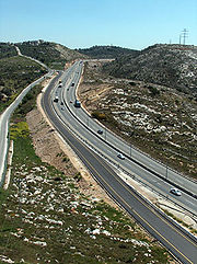
), is the main highway connecting Modi'in with Jerusalem and Tel Aviv
Tel Aviv
Tel Aviv , officially Tel Aviv-Yafo , is the second most populous city in Israel, with a population of 404,400 on a land area of . The city is located on the Israeli Mediterranean coastline in west-central Israel. It is the largest and most populous city in the metropolitan area of Gush Dan, with...
, and also serves as a secondary connection between the Tel Aviv area
Gush Dan
The Tel Aviv Metropolitan Area , or Gush Dan , is a metropolitan area including areas from both the Tel Aviv and the Central Districts of Israel. The area is closely linked to the city of Tel Aviv through social, economic, and cultural ties. It is located along the Israeli Mediterranean coastline...
and Jerusalem. While technically listed as a regional road, it is for the most part a divided, four-lane
Dual carriageway
A dual carriageway is a class of highway with two carriageways for traffic travelling in opposite directions separated by a central reservation...
highway which utilises some grade separation
Grade separation
Grade separation is the method of aligning a junction of two or more transport axes at different heights so that they will not disrupt the traffic flow on other transit routes when they cross each other. The composition of such transport axes does not have to be uniform; it can consist of a...
and interchange
Interchange (road)
In the field of road transport, an interchange is a road junction that typically uses grade separation, and one or more ramps, to permit traffic on at least one highway to pass through the junction without directly crossing any other traffic stream. It differs from a standard intersection, at which...
s, as well as major at-grade intersection
At-grade intersection
An at-grade intersection is a junction at which two or more transport axes cross at the same level .-Traffic management:With areas of high or fast traffic, an at-grade intersection normally requires a traffic control device such as a stop sign, traffic light or railway signal to manage conflicting...
s, and thus is not classified as a motorway, even though there is a short motorway section on its western end, connecting it to westbound Highway 1
Highway 1 (Israel)
Highway 1 , is the main highway connecting Tel Aviv with Jerusalem.-History:The section between Latrun and Jerusalem roughly follows an ancient path connecting Jaffa and Jerusalem...
.
The highway departs Highway 1 and Highway 6
Highway 6 (Israel)
Highway 6 , widely known as the Trans-Israel Highway or Cross-Israel Highway , is a major electronic toll highway in Israel. The highway was officially dedicated as the Yitzhak Rabin Highway , though this name is not commonly used. It started operating in the early 2000s and is being lengthened as...
at Ben Shemen Interchange
Ben Shemen Interchange
Ben Shemen Interchange is a major freeway interchange complex in central Israel, connecting Highway 1, Highway 6, Route 443 and Route 444, as well as several local roads. The interchange is located near moshav Ben Shemen and Ben Shemen Forest, hence its name...
, and continues eastwards to Shilat
Shilat
Shilat is a moshav in Israel located around a kilometre north of Modi'in, just west of the Green Line. It falls under the jurisdiction of Hevel Modi'in Regional Council...
junction, which serves as the entrance for the Modi'in area. It continues east into the West Bank
West Bank
The West Bank ) of the Jordan River is the landlocked geographical eastern part of the Palestinian territories located in Western Asia. To the west, north, and south, the West Bank shares borders with the state of Israel. To the east, across the Jordan River, lies the Hashemite Kingdom of Jordan...
in the Matte Binyamin Regional Council
Matte Binyamin Regional Council
Mateh Binyamin Regional Council is a regional council covering 42 Israeli settlements in the southern Samarian hills of the West Bank. The seat of the council is Psagot. The council is named for the ancient Israelite tribe of Benjamin, whose territory roughly corresponds to that of the council.In...
, near Ramallah
Ramallah
Ramallah is a Palestinian city in the central West Bank located 10 kilometers north of Jerusalem, adjacent to al-Bireh. It currently serves as the de facto administrative capital of the Palestinian National Authority...
, where it becomes Jerusalem's Begin Expressway
Begin Expressway
Route 404, usually referred to as Menachem Begin Expressway is an urban freeway in western Jerusalem named after sixth Israeli Prime Minister Menachem Begin. Local Jerusalemites simply refer to it as 'Begin'...
via the newly designated Highway 45
Highway 45 (Israel)
Highway 45 is the official designation of a 3.4 km stretch of highway forming a continuous conection between Route 443 from Lod via the Ben Shemen Interchange and Route 404 to central Jerusalem...
. A spur, road 436, links it with Giv'at Ze'ev
Giv'at Ze'ev
Giv'at Ze'ev is an Israeli settlement and town governed by a local council, located in the West Bank five kilometers northwest of Jerusalem. While it lies within the borders of the Matte Binyamin Regional Council, it is a separate municipal entity...
and the Jerusalem neighborhood of Ramot
Ramot
Ramot , also known as Ramot Alon , is a large housing development in northwestern Jerusalem. Because part of Ramot lies north of the Green Line in East Jerusalem, the international community considers Ramot an Israeli settlement that is illegal under international law. Israel disputes this and...
.
Problems in antiquity
The road was the site of many battles in antiquity due to its unique geography, most famously part of the biblical story of JoshuaJoshua
Joshua , is a minor figure in the Torah, being one of the spies for Israel and in few passages as Moses's assistant. He turns to be the central character in the Hebrew Bible's Book of Joshua...
, and the combat between the Macabees and the Seleucid Empire
Seleucid Empire
The Seleucid Empire was a Greek-Macedonian state that was created out of the eastern conquests of Alexander the Great. At the height of its power, it included central Anatolia, the Levant, Mesopotamia, Persia, today's Turkmenistan, Pamir and parts of Pakistan.The Seleucid Empire was a major centre...
. As opposed to the modern Highway 1, which twists and turns in gullies on its route from the coastal plain
Israeli Coastal Plain
The Israeli coastal plain is the narrow coastal plain along Israel's Mediterranean Sea coast which houses 70% of the country's population. The plain extends north to south and is divided into a number of areas; the Plain of Zebulun , Hof HaCarmel , the Sharon plain , and the Plain of Judea The...
to the Judean hills, the central portion of Highway 443 ascends along a ridge line, and thus maintains a relatively stable grade.
see also: Bet-Horon
Problems for Palestinians
Usage of this road is highly problematic for Palestinians, although they do have a legal right to use it.Several access roads connecting Palestinian villages with Route 443 in the West Bank portion have been closed since the September 2000 outbreak of the Second Intifada. Frequent fire bomb
Molotov cocktail
The Molotov cocktail, also known as the petrol bomb, gasoline bomb, Molotov bomb, fire bottle, fire bomb, or simply Molotov, is a generic name used for a variety of improvised incendiary weapons...
attacks and fatal shootings on Israeli traffic saw the erection of anti-sniper barricades on parts of the highway adjacent to Palestinian populated areas.
In March 2008, the Israel's Supreme Court
Supreme Court of Israel
The Supreme Court is at the head of the court system and highest judicial instance in Israel. The Supreme Court sits in Jerusalem.The area of its jurisdiction is all of Israel and the Israeli-occupied territories. A ruling of the Supreme Court is binding upon every court, other than the Supreme...
upheld for six more months the IDF's right to limit Palestinian traffic to prevent attacks, challenged by the Association for Civil Rights in Israel
Association for Civil Rights in Israel
The Association for Civil Rights in Israel was created as an independent non-partisan organization to protect human rights and civil rights in Israel and the territories under its control....
. The Israeli Human Rights Group B'Tselem
B'Tselem
B'Tselem is an Israeli non-governmental organization . It calls itself "The Israeli Information Center for Human Rights in the Occupied Territories"...
has also criticized the closure of route 443 for Palestinians as an example of Collective punishment
Collective punishment
Collective punishment is the punishment of a group of people as a result of the behavior of one or more other individuals or groups. The punished group may often have no direct association with the other individuals or groups, or direct control over their actions...
, which is illegal under International law
International law
Public international law concerns the structure and conduct of sovereign states; analogous entities, such as the Holy See; and intergovernmental organizations. To a lesser degree, international law also may affect multinational corporations and individuals, an impact increasingly evolving beyond...
. On December 29, 2009 Israel's High Court of Justice accepted the Association for Civil Rights in Israel
Association for Civil Rights in Israel
The Association for Civil Rights in Israel was created as an independent non-partisan organization to protect human rights and civil rights in Israel and the territories under its control....
's petition against an IDF order barring Palestinians from driving on Highway 443. The ruling came into effect on May 28, 2010, allowing Palestinians to use the road for the first time since 2002, when it was closed following Palestinian attacks on Israeli motorists during the Second Intifada.
Junctions and interchanges (west to east)
| km | Name | Type | Meaning | Location | Road(s) Crossed |
|---|---|---|---|---|---|
| 0 | צומת גינתון (Ginaton Junction) |
Little Garden | Lod Lod Lod is a city located on the Sharon Plain southeast of Tel Aviv in the Center District of Israel. At the end of 2010, it had a population of 70,000, roughly 75 percent Jewish and 25 percent Arab.The name is derived from the Biblical city of Lod... |
 (Highway 40 Highway 40 (Israel) Highway 40 is a north-south intercity road in Israel. At 302 km long, it is the second longest highway in Israel, after Highway 90. The highway runs from Kfar Sava in the center of Israel to the Arabah in the south, serving as a main connection between central Israel and Be'er Sheva.-Route... ) |
|
| 0.8 | צומת בו שמן (Ben Shemen Junction) |
Fruitful | Moshav Ben Shemen Ben Shemen Ben Shemen is a moshav in central Israel. Located around four kilometres east of Lod, it falls under the jurisdiction of Hevel Modi'in Regional Council. In 2006 it had a population of 627.... , Moshav Ginaton Ginaton Ginaton is a moshav in central Israel. Located near Ben Shemen, it falls under the jurisdiction of Hevel Modi'in Regional Council. In 2006 it had a population of 737.... |
local roads | |
| 1.4 | Ben Shemen Youth Village and Agricultural School Ben Shemen Youth Village Ben Shemen Youth Village is a youth village and agricultural boarding school in central Israel. Located near Ben Shemen and Ginaton, it falls under the jurisdiction of Judaism Hevel Modi'in Regional Council. In 2006, it had a population of 627.-History:... |
local road | |||
| 3 | מחלף בן שמן (Ben Shemen Interchange Ben Shemen Interchange Ben Shemen Interchange is a major freeway interchange complex in central Israel, connecting Highway 1, Highway 6, Route 443 and Route 444, as well as several local roads. The interchange is located near moshav Ben Shemen and Ben Shemen Forest, hence its name... ) |
 |
Named after location | Ben Shemen Ben Shemen Ben Shemen is a moshav in central Israel. Located around four kilometres east of Lod, it falls under the jurisdiction of Hevel Modi'in Regional Council. In 2006 it had a population of 627.... |
  (Highway 1 Highway 1 (Israel) Highway 1 , is the main highway connecting Tel Aviv with Jerusalem.-History:The section between Latrun and Jerusalem roughly follows an ancient path connecting Jaffa and Jerusalem... , Highway 6 Highway 6 (Israel) Highway 6 , widely known as the Trans-Israel Highway or Cross-Israel Highway , is a major electronic toll highway in Israel. The highway was officially dedicated as the Yitzhak Rabin Highway , though this name is not commonly used. It started operating in the early 2000s and is being lengthened as... , Route 444) |
| 3.3 | צומת מודיעים (Modi'im Junction) |
Named after location of ancient village Modi'im Informers |
north to Rosh HaAyin Rosh HaAyin Rosh HaAyin is a city in the Center District of Israel. To the west of Rosh HaAyin is the fortress of Antipatris and the source of the Yarkon River. To the southeast is the fortress of Migdal Afek... |
 Route 444 |
|
| 3.4 | צומת מודיעים (Modi'im Junction) |
south to Kfar Daniel Kfar Daniel Kfar Daniel is a moshav shitufi in central Israel. Located around four kilometres south-east of Lod and covering 2,900 dunams, it falls under the jurisdiction of Hevel Modi'in Regional Council. In 2006 it had a population of 297.... , Moshav Gimzo Gimzo Gimzo is a religious moshav in central Israel. Located between Lod and Modi'in, it falls under the jurisdiction of Hevel Modi'in Regional Council... |
local road 4314 | ||
| 4.9 | צומת נאות קדומים (Neot Kedumim Junction) |
 |
Beauties of Ancient Times | Neot Kedumim Neot Kedumim Neot Kedumim is a Biblical garden and nature preserve located near Modi'in, mid-way between Jerusalem and Tel Aviv, Israel. It is a unique endeavor to re-create the physical setting of the Bible.... Nature Reserve |
local road |
| 6 | local road | ||||
| 7.5 | |
"Tombs of the Maccabees Maccabees The Maccabees were a Jewish rebel army who took control of Judea, which had been a client state of the Seleucid Empire. They founded the Hasmonean dynasty, which ruled from 164 BCE to 63 BCE, reasserting the Jewish religion, expanding the boundaries of the Land of Israel and reducing the influence... " |
local road | ||
| 8.7 | צומת מבוא מודיעים (Mevo Modi'im Junction) |
Gateway to Modi'in | Mevo Modi'im | local road | |
| 10.2 | צומת מכבים (Maccabim Junction) |
Named for The Maccabees Maccabees The Maccabees were a Jewish rebel army who took control of Judea, which had been a client state of the Seleucid Empire. They founded the Hasmonean dynasty, which ruled from 164 BCE to 63 BCE, reasserting the Jewish religion, expanding the boundaries of the Land of Israel and reducing the influence... |
entrance to Modi'in | Road 4466 | |
| 12.8 | צומת שילת (Shilat Junction) |
Named after location | Shilat Shilat Shilat is a moshav in Israel located around a kilometre north of Modi'in, just west of the Green Line. It falls under the jurisdiction of Hevel Modi'in Regional Council... Modi'in-Maccabim-Re'ut Modi'in-Maccabim-Re'ut Modi'in-Maccabim-Re'ut is a city in the Center District of Israel located approximately halfway between Jerusalem and Tel Aviv. It was formed in 2003 by the merger of Modi'in and Maccabim-Re'ut... Modi'in Illit Modi'in Illit Modi'in Illit is a Haredi Israeli settlement and a city in the West Bank, situated midway between Jerusalem and Tel Aviv. Modi'in Illit was granted city status by the Israeli government in 2008. It is located six kilometres northeast of Modi'in-Maccabim-Re'ut and is often referred to as Kiryat... |
 (Route 446), Hashmonaim (Route 446), HashmonaimHashmonaim Hashmonaim is an Israeli settlement in the Binyamin Region, in the northern section of the West Bank. The settlement located off Route 443, and on Route 446, which connects between Modi'in and Ariel. Less than a kilometer East of Hashmonaim, is the major Haredi settelment, Modi'in Illit , the... blvd. |
|
| 13 | צומת מכבים-רעות (Maccabim-Re'ut Junction) |
The Maccabees Maccabees The Maccabees were a Jewish rebel army who took control of Judea, which had been a client state of the Seleucid Empire. They founded the Hasmonean dynasty, which ruled from 164 BCE to 63 BCE, reasserting the Jewish religion, expanding the boundaries of the Land of Israel and reducing the influence... -Friendship |
Maccabim-Re'ut | Yair Parag Road | |
| 13.9 | Green Line | ||||
| 14.1 | Maccabim Security Checkpoint | ||||
 ↑NO westbound through-traffic for green (Palestinian Authority) license plates↑ ↑NO westbound through-traffic for green (Palestinian Authority) license plates↑ |
|||||
| 14.3 | צומת בית חורון (Beit Horon Junction) |
|
Maccabim-Re'ut Beit Sira Beit Sira Beit Sira is a Palestinian village in the central West Bank, located 22 kilometers west of Ramallah and is a part of the Ramallah and al-Bireh Governorate. The village is situated along the Green Line and during the 1948 Arab-Israeli War, around 4,000 dunams of its land became a part of the... |
 Highway 3 Highway 3 (Israel) Highway 3 is a highway in Israel. It begins at Beit Horon junction with Highway 443 near Modi'in, it passes through Kiryat Malakhi, and it ends a junction with Highway 4 on the outskirts of Ashkelon.- Plan for the future :... (blocked) Route 455 |
|
| 23.4 | מחלף בית חורון (Beit Horon Interchange) |
|
Named after location House of Horon |
Beit Horon Beit Horon Beit Horon is an Israeli settlement and communal village bordering Route 443, the biblical pass of Beit Horon, between Modi'in and Jerusalem. Beit Horon receives municipal services from the Matte Binyamin Regional Council... al-Tira |
local road |
| 28.3 | צומת גבעת זאב (Giv'at Ze'ev Junction) |
Wolf Hill | Giv'at Ze'ev Giv'at Ze'ev Giv'at Ze'ev is an Israeli settlement and town governed by a local council, located in the West Bank five kilometers northwest of Jerusalem. While it lies within the borders of the Matte Binyamin Regional Council, it is a separate municipal entity... , Jerusalem |
Highway 45 Highway 45 (Israel) Highway 45 is the official designation of a 3.4 km stretch of highway forming a continuous conection between Route 443 from Lod via the Ben Shemen Interchange and Route 404 to central Jerusalem... to  (Begin Expressway) (Begin Expressway) |
|