

High Huts of the White Mountains
Encyclopedia
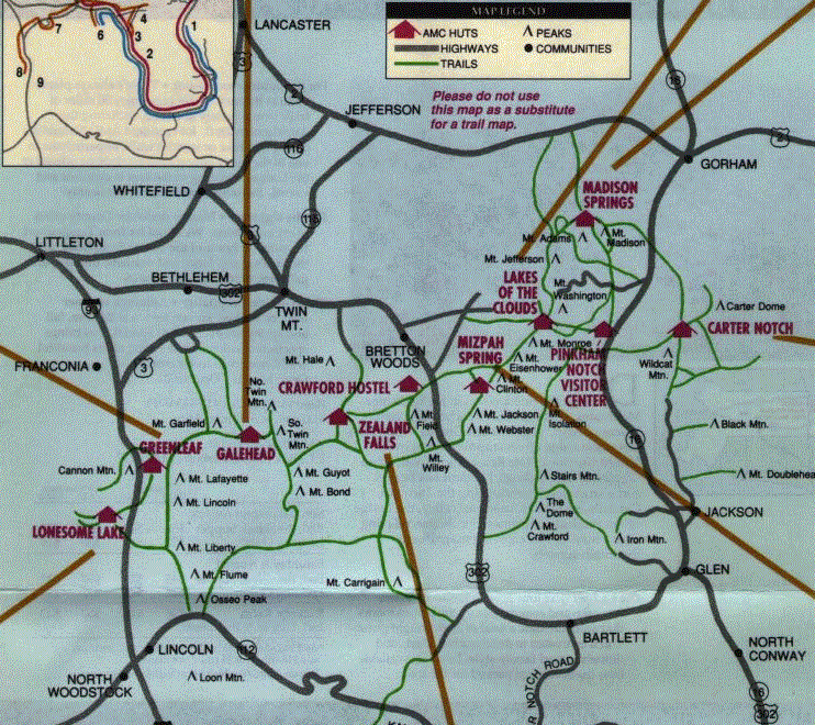
The High Huts of the White Mountains are a series of eight mountain huts in the White Mountains
White Mountains (New Hampshire)
The White Mountains are a mountain range covering about a quarter of the state of New Hampshire and a small portion of western Maine in the United States. Part of the Appalachian Mountains, they are considered the most rugged mountains in New England...
, in the U.S. state of New Hampshire
New Hampshire
New Hampshire is a state in the New England region of the northeastern United States of America. The state was named after the southern English county of Hampshire. It is bordered by Massachusetts to the south, Vermont to the west, Maine and the Atlantic Ocean to the east, and the Canadian...
, owned and maintained by the Appalachian Mountain Club
Appalachian Mountain Club
The Appalachian Mountain Club is one of the United States' oldest outdoor groups. Created in 1876 to explore and preserve the White Mountains in New Hampshire, it has expanded throughout the northeastern U.S., with 12 chapters stretching from Maine to Washington, D.C...
. Modeled after similar huts in the Alps
Alps
The Alps is one of the great mountain range systems of Europe, stretching from Austria and Slovenia in the east through Italy, Switzerland, Liechtenstein and Germany to France in the west....
, they are positioned at intervals along the Appalachian Trail
Appalachian Trail
The Appalachian National Scenic Trail, generally known as the Appalachian Trail or simply the AT, is a marked hiking trail in the eastern United States extending between Springer Mountain in Georgia and Mount Katahdin in Maine. It is approximately long...
, allowing "thru-hikers" (those who hike the entire Appalachian Trail) to benefit from their services. They are generally separated by six to eight miles, about a day's hike.
Hikers can reserve overnight bunks at the huts, which hold from 36 to 90 people each. In summer season (June through mid-September) the huts are "full service", serving dinner and breakfast. Three huts stay open the rest of the year as "self service", allowing guests to cook their own food in the kitchen.
The huts are maintained by a team of five to nine caretakers - often called "the croo," using that spelling - during full-service season. Each crew member works for eleven days on, three days off. During the eleven working days, they must make four trips back down the mountain to get perishable food and other supplies, carrying heavy loads. At the beginning of each season, fuel and supplies are flown into the huts by helicopter.
Although extremely popular, the huts are also controversial, facilitating thousands of hikers entering the back woods and environmentally sensitive areas above tree line. Four years and an environmental impact statement
Environmental impact statement
An environmental impact statement , under United States environmental law, is a document required by the National Environmental Policy Act for certain actions "significantly affecting the quality of the human environment". An EIS is a tool for decision making...
were required to get the huts' permits renewed by the U.S. Forest Service in 1999.
Hut histories
In describing the huts' relative positions, "south" and "north" refer to location along the AT, though the trail runs roughly from west to east through the White Mountains. The following huts are presented in "south" to "north" order.Lonesome Lake Hut
The southernmost hut in the system (44.1385°N 71.7033 °W) started out in 1876 as a fishing camp on Lonesome LakeLonesome Lake (New Hampshire)
Lonesome Lake is a water body located in Franconia Notch in the White Mountains of New Hampshire, south of Cannon Mountain. The lake is reachable by hiking trails from the Franconia Notch Parkway and features an Appalachian Mountain Club hut on its southwest shore.The lake lies in the Merrimack...
, with cabins built by author W.C. Prime. Lonesome Lake Hut officially became part of the AMC hut system in 1929, when the State of New Hampshire bought the land and invited the club to run it as a shelter. It has since become a popular hut for families due to its low altitude and relative ease of ascent. It is notable for being the first hut managed by an all-female croo, in 1979. It is the second lowest hut in the system and is tied with Greenleaf, its closest neighbor, for the fourth highest capacity.
Greenleaf Hut
Construction on Greenleaf (44.1603°N 71.6604 °W) was completed in 1930 and was the first hut project to use a team of burroBurro
The burro is a small donkey used primarily as a pack animal. In addition, significant numbers of feral burros live in the Southwestern United States, where they are protected by law, and in Mexico...
s to carry materials. Greenleaf was also the first hut in the system with running waters and indoor toilets, which symbolized the shift in concept from that of the huts being simple shelters to that of the huts being more of a mountainside hostel. The design on Greenleaf — a central dining room and kitchen flanked by two bunkrooms — became the model for Galehead and Zealand Falls, both constructed within the next year. This hut was also the first to leave behind the stone and masonry construction technique utilized by earlier huts. Much of the funding for the construction of the hut came from Colonel Charles Greenleaf, for whom the hut is named. Guests at Greenleaf enjoy spectacular views of Franconia Ridge due to the hut's position on a prominent shoulder of Mount Lafayette. Greenleaf is the third highest hut in the system and is tied with Lonesome Lake Hut for the fourth highest capacity. Lonesome is also the hut's closest southern neighbor, with Galehead Hut to the north.
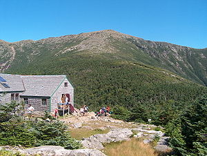
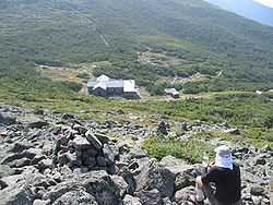
Galehead Hut
Construction on Galehead hut (44.1879°N 71.5688 °W) began in 1931, using wood from the surrounding trees. It was completed in 1932, along with Zealand Falls Hut, its closest northern neighbor. Originally, the hut used the small space under the front porch to store perishable foods. In 1938, the hut gained a temporary 360 degree view when the Great New England HurricaneNew England Hurricane of 1938
The New England Hurricane of 1938 was the first major hurricane to strike New England since 1869...
blew over all the surrounding trees. The building itself survived the storm, but it could not last indefinitely — in June 2000, a brand-new Galehead opened to the public. The new hut included provisions to make it compliant with the Americans with Disabilities Act including a wheelchair ramp, even though it is 5 miles (8 km) by a rough trail from the nearest trailhead. As the hut is located nearly 4000 feet (1,219.2 m) above sea level and five miles from the nearest trailhead, the vast majority of the building materials had to be carried in; thus mainly lightweight materials were utilized. Despite this challenge, new features for the hut included composting toilet
Composting toilet
A composting toilet is a dry toilet that using a predominantly aerobic processing system that treats excreta, typically with no water or small volumes of flush water, via composting or managed aerobic decomposition...
s (already in use at Mizpah Spring Hut, Carter Notch Hut, and Lonesome Lake Hut), solar panels and a wind vane to produce power with little environmental impact, and the ability to withstand winds up to 125 mph (200 km/h). The latter was accomplished by fastening the foundation to the granite groundrock through drilling and grouting rebar
Rebar
A rebar , also known as reinforcing steel, reinforcement steel, rerod, or a deformed bar, is a common steel bar, and is commonly used as a tensioning device in reinforced concrete and reinforced masonry structures holding the concrete in compression...
. The hut is located on the rugged Garfield Ridge and is located 0.9 miles (1.4 km) from South Twin Mountain
South Twin Mountain (New Hampshire)
South Twin Mountain is a mountain located in Grafton County, New Hampshire. The mountain is part of the Twin Range of the White Mountains. South Twin forms the high point of a north-south ridge, with North Twin Mountain lying approximately one mile to the north and Mount Guyot two miles to the...
and 0.5 miles (804.7 m) from Galehead Mountain
Galehead Mountain
Galehead Mountain is a mountain located in Grafton County, New Hampshire. The mountain is part of the Twin Range of the White Mountains.Galehead is flanked to the east by South Twin Mountain, and to the west by Mount Garfield....
. The hut is tied with Mizpah Springs Hut for the fourth highest hut and sleeps the second lowest number of people. Greenleaf hut is the closest hut to the south.
Zealand Falls Hut
Zealand Falls Hut (44.1960°N 71.4944 °W) was completed in 1932 along with Galehead and has been open in the winter season since 1973. It, like Lonesome Lake hut, is notable as a "family" hut due to its low altitude and relatively easy approach climb. It also has the lowest capacity of all the huts, sleeping little more than a third of the largest capacity hut. Zealand is neighbored by Galehead to the south and Mizpah Spring to the north.Mizpah Spring Hut
MizpahMizpah
Mizpah or Miz'peh may refer to:* one of several places in ancient Israel:** Mizpah in Benjamin, a city near Jerusalem** Mizpah in Gilead , the place where Laban overtook Jacob on his return to Canaan...
Spring Hut (44.2193°N 71.3695 °W) was originally built in 1964, and although there are newer buildings in the system, this makes Mizpah the newest hut site in the system. The building is designed to withstand 200 mph (320 km/h) winds and was built with materials brought in by helicopter. This hut is tied with Galehead Hut for the fourth highest hut and sleeps the second largest number of people. Its immediate neighbor to the south is Zealand Falls Hut, and its immediate neighbor to the north is Lakes of the Clouds hut.
Lakes of the Clouds Hut
The highest, largest, and most popular hut in the system, Lakes of the Clouds Hut (44.2588°N 71.3190 °W) started as a shelter built in 1901 in response to the deaths in the previous year of two hikers caught in a storm on their way to an AMC meeting atop Mount Washington. Fourteen years later it was rebuilt as a hut, and has since been renovated at least five times — in 1922, 1927, 1947, 1969 and 2005. Despite its position as the highest of the huts, it is also the most easily accessible due to its proximity to the summit of Mount Washington, accessible both by car and by the Mount Washington Cog Railway, a popular tourist attraction. It is located adjacent to its namesake Lakes of the CloudsLakes of the Clouds
The Lakes of the Clouds are a set of small ponds located at the col between Mount Monroe and Mount Washington in the White Mountains of the U.S. state of New Hampshire...
—two small alpine tarns
Tarn (lake)
A tarn is a mountain lake or pool, formed in a cirque excavated by a glacier. A moraine may form a natural dam below a tarn. A corrie may be called a cirque.The word is derived from the Old Norse word tjörn meaning pond...
— and just below the 5372 ft (1,637.4 m) summit of Mount Monroe
Mount Monroe
Mount Monroe is the highest peak south of Mount Washington in the Presidential Range of New Hampshire. It is the fourth highest mountain on the 4000 footers list for New Hampshire. The Lakes of the Clouds, and its AMC hut, lie nestled at the col between Mount Monroe and neighboring Mount...
. The hut is the largest of the AMC chain: It provides bunks for 90 hikers. Because of its size and popularity, it is known as "Lakes of the Crowds". Mizpah Spring Hut is the closest hut to the south and Madison Spring is the closest hut to the north.
Madison Spring Hut
It is the second highest hut in the chain, and sleeps the third highest number of guests. The hut is accessed most directly from the Valley Way Trail (from the Appalachia parking lot). It is generally considered the most difficult of the full-service huts to access, based on distance and elevation required to reach it. To the south is Lakes of the Clouds Hut and to the north is Carter Notch Hut.
Carter Notch Hut
Carter NotchCarter Notch
Carter Notch is a high mountain pass through the White Mountains of New Hampshire. It is traversed only by hiking trails. The notch is located in the Carter-Moriah Range within the White Mountain National Forest, in Bean's Purchase, Coos County, New Hampshire. It is bordered to the west by...
Hut (44.2591°N 71.1955 °W) is the easternmost hut in the system and is open year-round. Between 1996 and 2006, it operated on a self service basis; since then it has resumed operating as a full service hut during the summer season, remaining self-service the rest of the year. The site's use as a shelter began in 1904 as a simple log cabin
Log cabin
A log cabin is a house built from logs. It is a fairly simple type of log house. A distinction should be drawn between the traditional meanings of "log cabin" and "log house." Historically most "Log cabins" were a simple one- or 1½-story structures, somewhat impermanent, and less finished or less...
; the building was rebuilt as a hut in 1914, making Carter Notch the oldest building in the hut chain. There are two bunkhouses located a short distance from the main hut structure; thus from the cliffs above, the hut is viewed as a small compound. There are two small ponds located nearby, as well as a tremendous boulder field. Both are results of an 1869 landslide that ravaged nearby Carter Dome's north slopes. Carter Notch helped establish the hut as a viable pursuit for the AMC, and after its initial success, the group began to lay plans for a hut system. Currently, a nearby cave is used to store cheese, butter, and other perishables. It has both the third lowest altitude and the third lowest capacity of any hut. Its closest southern neighbor is Madison Spring Hut.
Comparison of huts
| Hut | Location | Elevation | Capacity | Sleeping Arrangement | 2009 Season Dates |
|---|---|---|---|---|---|
| Carter Notch Hut | Carter Notch Carter Notch is a high mountain pass through the White Mountains of New Hampshire. It is traversed only by hiking trails. The notch is located in the Carter-Moriah Range within the White Mountain National Forest, in Bean's Purchase, Coos County, New Hampshire. It is bordered to the west by... |
||||
| Galehead Hut | |||||
| Greenleaf Hut | |||||
| Lakes of the Clouds Hut | Mount Washington (New Hampshire) Mount Washington is the highest peak in the Northeastern United States at , famous for dangerously erratic weather. For 76 years, a weather observatory on the summit held the record for the highest wind gust directly measured at the Earth's surface, , on the afternoon of April 12, 1934... |
||||
| Lonesome Lake Hut | Cannon Mountain (New Hampshire) Cannon Mountain is a peak in the White Mountains of New Hampshire. Known for both its technical rock and ice climbing and its skiing , the mountain was home to the Old Man of the Mountain until the formation collapsed on May 3, 2003... |
||||
| Madison Spring Hut | Mountain pass A mountain pass is a route through a mountain range or over a ridge. If following the lowest possible route, a pass is locally the highest point on that route... between Mount Madison Mount Madison Mount Madison is a mountain in the Presidential Range of New Hampshire in the United States. It is named after the fourth U.S. President, James Madison.... and Mount Adams Mount Adams (New Hampshire) Mount Adams, elevation above sea level, is a mountain in New Hampshire, the second highest peak in the Northeast United States after its nearby neighbor, Mt. Washington. Located in the northern Presidential Range, Mount Adams was named after John Adams, the second president of the United States.... |
||||
| Mizpah Spring Hut | Mount Pierce (New Hampshire) Mount Pierce is a mountain in the Presidential Range in the White Mountains of New Hampshire that is approximately 4,310 feet high... (often referred to as Mount Clinton) |
||||
| Zealand Falls Hut | Zealand Notch Zealand Notch is a mountain pass located in the White Mountains of New Hampshire, United States. It is located in the towns of Bethlehem and Lincoln, near the northeastern corner of the Pemigewasset Wilderness. The center of the notch is traversed by hiking trails and is located approximately 2... |