

Hessel Gerritsz
Encyclopedia
– buried September 4, 1632, Amsterdam
Amsterdam
Amsterdam is the largest city and the capital of the Netherlands. The current position of Amsterdam as capital city of the Kingdom of the Netherlands is governed by the constitution of August 24, 1815 and its successors. Amsterdam has a population of 783,364 within city limits, an urban population...
) was a Dutch
Dutch Republic
The Dutch Republic — officially known as the Republic of the Seven United Netherlands , the Republic of the United Netherlands, or the Republic of the Seven United Provinces — was a republic in Europe existing from 1581 to 1795, preceding the Batavian Republic and ultimately...
engraver, cartographer and publisher. Despite strong competition, he is considered by some “unquestionably the chief Dutch cartographer of the 17th century”
Early career
He started in AlkmaarAlkmaar
Alkmaar is a municipality and a city in the Netherlands, in the province of Noord Holland. Alkmaar is well known for its traditional cheese market. For tourists, it is a popular cultural destination.-History:...
as an apprentice to Willem Jansz Blaeu, who was ten years his elder. Gerritsz moved with Blaeu’s workshop to Amsterdam, where he married Geertje Gijsberts of Alkmaar in 1607. They had eight children. Geertje would die before 1624, when Hessel remarried. By 1610 he had a printing workshop on his own. Many of his engravings and maps made it into the atlases of Blaeu, Janssonius
Jan Janssonius
Johannes Janssonius was a Dutch cartographer who lived and worked in Amsterdam in the 17th century....
, and others.
Independent printer
Gerritsz produced a world map in 1612 that included the discoveries of QueirósPedro Fernandes de Queirós
Pedro Fernandes de Queirós , was a Portuguese navigator best known for his involvement with Spanish voyages of discovery in the Pacific Ocean, in particular the 1595-1596 voyage of Alvaro de Mendaña de Neira, and for leading a 1605-1606 expedition which crossed the Pacific in search of Terra...
and specifically indicated “Austrialia del Espiritu Santo”, now known to be Vanuatu
Vanuatu
Vanuatu , officially the Republic of Vanuatu , is an island nation located in the South Pacific Ocean. The archipelago, which is of volcanic origin, is some east of northern Australia, northeast of New Caledonia, west of Fiji, and southeast of the Solomon Islands, near New Guinea.Vanuatu was...
, but for long thought to be part of the “South land”. The map was very influential on Dutch and French representions of the South Pacific in the 17th and 18th century, and was together with Queirós' publications influential in establishing the name “Australia”. In 1613 Gerritsz wrote and published a “History of the land named Spitsbergen
Spitsbergen
Spitsbergen is the largest and only permanently populated island of the Svalbard archipelago in Norway. Constituting the western-most bulk of the archipelago, it borders the Arctic Ocean, the Norwegian Sea and the Greenland Sea...
”, describing the discovery, early voyages and whaling activities on these islands. This volume also showcases Gerritsz’ considerable talents as an engraver (see for example his depiction of a walrus and pup). The same year he edited a map of Russia
Russia
Russia or , officially known as both Russia and the Russian Federation , is a country in northern Eurasia. It is a federal semi-presidential republic, comprising 83 federal subjects...
prepared by the future Feodor II of Russia
Feodor II of Russia
Fyodor II Borisovich Godunov of Russia was a tsar of Russia during the Time of Troubles. He was born in Moscow, the son and successor to Boris Godunov...
as tsarevich, and re-edited it in 1614 with some additions and corrections; it was reproduced by the Blaeu firm until 1665. Another example of an engraving is his often reproduced 1619 posthumous portrait of the playwright Bredero
Gerbrand Adriaensz Bredero
Gerbrand Adriaensz Bredero was a Dutch poet and playwright in the period known as the Dutch Golden Age.-Life:...
.
Official cartographer of the VOC
His fame as cartographer grew rapidly to the point that on 16 October 1617 he was appointed the first exclusive cartographer of the Dutch East India CompanyDutch East India Company
The Dutch East India Company was a chartered company established in 1602, when the States-General of the Netherlands granted it a 21-year monopoly to carry out colonial activities in Asia...
(the VOC), probably the most strategic position a cartographer could have in those days. He got the position on recommendation of Petrus Plancius
Petrus Plancius
Petrus Plancius was a Dutch astronomer, cartographer and clergyman. He was born as Pieter Platevoet in Dranouter, now in Heuvelland, West Flanders. He studied theology in Germany and England...
, chief scientist of the VOC, who did not get along with the senior Willem Blaeu (Blaeu and Gerritsz remained friends). Gerritsz kept this post until his death, after which the position was held by the Blaeu family, starting with Willem Jansz, until 1705.
All charts and logs from returning VOC merchants and explorers sailors had to be submitted to Gerritsz and thanks to the wealth of new information several breakthrough maps came from his hands. In return Gerritsz’ charts accompanied all VOC captains on their voyages.
Mapping of Australia

Indonesia
Indonesia , officially the Republic of Indonesia , is a country in Southeast Asia and Oceania. Indonesia is an archipelago comprising approximately 13,000 islands. It has 33 provinces with over 238 million people, and is the world's fourth most populous country. Indonesia is a republic, with an...
n islands, far better represented than on earlier efforts, and, for the first time, the (Northwest) coast of Australia
Australia
Australia , officially the Commonwealth of Australia, is a country in the Southern Hemisphere comprising the mainland of the Australian continent, the island of Tasmania, and numerous smaller islands in the Indian and Pacific Oceans. It is the world's sixth-largest country by total area...
. In 1622 he bundled many of his maps in a map book for the VOC. This map book included a 1622 map of the Pacific, probably the "Map of the Great South Sea" that Abel Tasman
Abel Tasman
Abel Janszoon Tasman was a Dutch seafarer, explorer, and merchant, best known for his voyages of 1642 and 1644 in the service of the VOC . His was the first known European expedition to reach the islands of Van Diemen's Land and New Zealand and to sight the Fiji islands...
consulted extensively on his voyage around Australia and to New Zealand
New Zealand
New Zealand is an island country in the south-western Pacific Ocean comprising two main landmasses and numerous smaller islands. The country is situated some east of Australia across the Tasman Sea, and roughly south of the Pacific island nations of New Caledonia, Fiji, and Tonga...
in 1642. In 1627 Gerritsz made a map, the Caert van't Landt van d'Eendracht
Caert van't Landt van d'Eendracht
Caert van't Landt van d'Eendracht is a 1627 map by Hessel Gerritsz. One of the earliest maps of Australia, it shows what little was then known of the west coast, based on a number of voyages beginning with the 1616 voyage of Dirk Hartog...
, entirely devoted to the discoveries of the West Australian coastline. Australia is called “Eendrachtsland”, a name given by Dirk Hartog
Dirk Hartog
Dirk Hartog was a 17th century Dutch sailor and explorer. Dirk Hartog's expedition was the third European group to land on Australian soil. He was the first to leave behind an artifact to record his visit, the Hartog plate. His name is sometimes alternatively spelled Dirck Hartog or Dierick...
after his stay on its coast in 1616, and which would be in use until the end of the 17th century.
In 1628, he added the 1627 charting of Australia’s South coast by François Thijssen
François Thijssen
François Thijssen or Frans Thijsz was a Dutch explorer who explored the southern coast of Australia.He was the captain of the ship t Gulden Zeepaerdt when sailing from Cape of Good Hope to Batavia...
to the map mentioned above, making this the first map showing a recognizable outline of Australia .
Later years
Gerritsz’ interest in the New World was so extensive that, unusual for a cartographer in his position, he joined on a 1628/29 voyage to BrazilBrazil
Brazil , officially the Federative Republic of Brazil , is the largest country in South America. It is the world's fifth largest country, both by geographical area and by population with over 192 million people...
and the Caribbean
Caribbean
The Caribbean is a crescent-shaped group of islands more than 2,000 miles long separating the Gulf of Mexico and the Caribbean Sea, to the west and south, from the Atlantic Ocean, to the east and north...
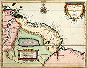
. He contributed the maps of Joannes de Laet
Joannes de Laet
Joannes or Johannes de Laet was a Dutch geographer and director of the Dutch West India Company. Philip Burden called his History of the New World, "...arguably the finest description of the Americas published in the seventeenth century" and "...one of the foundation maps of Canada"...
’s Beschrijvinghe van West-Indiën ("Description of the West Indies”) published in 1630. Especially his map of Florida, based on French and Spanish sources, became influential (e.g. for 200 years after, Florida would be known as “Tegesta” as Gerritsz had named it).
In 1632 Hessel Gerritsz died; he was buried in the Nieuwe Kerk on September 4. Willem Janszoon Blaeu would take his place as cartographer of the VOC in January of the following year.