
Heber-Overgaard, Arizona
Encyclopedia
Heber-Overgaard is a census-designated place
(CDP) in Navajo County
, Arizona
, United States
. Situated atop the Mogollon Rim
, the community lies at an elevation of around 6500 feet (1,981.2 m). The population was 2,722 at the 2000 census.
Heber was founded in 1876 or 1877, by members of The Church of Jesus Christ of Latter-day Saints (Mormons), and the town is named after Heber J. Grant
, a prominent Mormon. The Heber post office was established in 1890.
Overgaard was settled in the 1930s and was named after the owner of the first sawmill. It was originally called Oklahoma Flats.
Tourism, retirement and timbering are the foundations of Heber-Overgaard's economy.
According to the United States Census Bureau
, the CDP has a total area of 6.9 square miles (17.9 km²), all of it land.
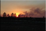
In 2002, the Rodeo-Chediski fire
was a wildfire that burned in Heber-Overgaard beginning on June 18, 2002, and was not controlled until July 7. It was the second worst forest fire in Arizona to date, consuming 467066 acres (1,890.2 km²).
of 2000, there were 2,722 people, 1,154 households, and 808 families residing in the CDP. The population density
was 391.4 people per square mile (151.2/km²). There were 3,178 housing units at an average density of 457.0 per square mile (176.6/km²). The racial makeup of the CDP was 94.89% White
, 0.07% Black
or African American
, 2.31% Native American
, 0.15% Asian
, 0.11% Pacific Islander
, 1.43% from other races
, and 1.03% from two or more races. 6.06% of the population were Hispanic
or Latino
of any race.
There were 1,154 households out of which 22.4% had children under the age of 18 living with them, 62.4% were married couples
living together, 4.9% had a female householder with no husband present, and 29.9% were non-families. 24.3% of all households were made up of individuals and 12.1% had someone living alone who was 65 years of age or older. The average household size was 2.36 and the average family size was 2.79.
In the CDP the population was spread out with 21.6% under the age of 18, 5.1% from 18 to 24, 19.3% from 25 to 44, 31.6% from 45 to 64, and 22.4% who were 65 years of age or older. The median age was 48 years. For every 100 females there were 105.1 males. For every 100 females age 18 and over, there were 104.5 males.
The median income for a household in the CDP was $28,665, and the median income for a family was $35,380. Males had a median income of $28,889 versus $22,750 for females. The per capita income
for the CDP was $15,596. About 11.7% of families and 16.4% of the population were below the poverty line, including 25.6% of those under age 18 and 5.4% of those age 65 or over.
Mountain Meadows Primary School, Capps Elementary School, Mogollon Junior High School, and Mogollon High School serve the community.
Census-designated place
A census-designated place is a concentration of population identified by the United States Census Bureau for statistical purposes. CDPs are delineated for each decennial census as the statistical counterparts of incorporated places such as cities, towns and villages...
(CDP) in Navajo County
Navajo County, Arizona
-2010:Whereas according to the 2010 U.S. Census Bureau:*49.3% White*0.9% Black*43.4% Native American*0.5% Asian*0.1% Native Hawaiian or Pacific Islander*2.5% Two or more races*3.3% Other races*10.8% Hispanic or Latino -2000:...
, Arizona
Arizona
Arizona ; is a state located in the southwestern region of the United States. It is also part of the western United States and the mountain west. The capital and largest city is Phoenix...
, United States
United States
The United States of America is a federal constitutional republic comprising fifty states and a federal district...
. Situated atop the Mogollon Rim
Mogollon Rim
The Mogollon Rim is a topographical and geological feature running across the U.S. state of Arizona. It extends approximately from northern Yavapai County eastward to near the border with New Mexico.-Description:...
, the community lies at an elevation of around 6500 feet (1,981.2 m). The population was 2,722 at the 2000 census.
Heber was founded in 1876 or 1877, by members of The Church of Jesus Christ of Latter-day Saints (Mormons), and the town is named after Heber J. Grant
Heber J. Grant
Heber Jeddy Grant was the seventh president of The Church of Jesus Christ of Latter-day Saints . He was ordained an apostle on October 16, 1882, on the same day as George Teasdale...
, a prominent Mormon. The Heber post office was established in 1890.
Overgaard was settled in the 1930s and was named after the owner of the first sawmill. It was originally called Oklahoma Flats.
Tourism, retirement and timbering are the foundations of Heber-Overgaard's economy.
Geography
Heber-Overgaard is located at 34°24′47"N 110°33′52"W (34.413157, -110.564393).According to the United States Census Bureau
United States Census Bureau
The United States Census Bureau is the government agency that is responsible for the United States Census. It also gathers other national demographic and economic data...
, the CDP has a total area of 6.9 square miles (17.9 km²), all of it land.
In 2002, the Rodeo-Chediski fire
Rodeo-Chediski fire
The Rodeo–Chediski Fire was a wildfire that burned in east-central Arizona beginning on June 18, 2002, and was not controlled until July 7. It was the worst forest fire in Arizona's recorded history until June 14th, 2011 when the Wallow Fire surpassed Rodeo-Chediski as the largest fire in Arizona...
was a wildfire that burned in Heber-Overgaard beginning on June 18, 2002, and was not controlled until July 7. It was the second worst forest fire in Arizona to date, consuming 467066 acres (1,890.2 km²).
Demographics
As of the censusCensus
A census is the procedure of systematically acquiring and recording information about the members of a given population. It is a regularly occurring and official count of a particular population. The term is used mostly in connection with national population and housing censuses; other common...
of 2000, there were 2,722 people, 1,154 households, and 808 families residing in the CDP. The population density
Population density
Population density is a measurement of population per unit area or unit volume. It is frequently applied to living organisms, and particularly to humans...
was 391.4 people per square mile (151.2/km²). There were 3,178 housing units at an average density of 457.0 per square mile (176.6/km²). The racial makeup of the CDP was 94.89% White
Race (United States Census)
Race and ethnicity in the United States Census, as defined by the Federal Office of Management and Budget and the United States Census Bureau, are self-identification data items in which residents choose the race or races with which they most closely identify, and indicate whether or not they are...
, 0.07% Black
Race (United States Census)
Race and ethnicity in the United States Census, as defined by the Federal Office of Management and Budget and the United States Census Bureau, are self-identification data items in which residents choose the race or races with which they most closely identify, and indicate whether or not they are...
or African American
Race (United States Census)
Race and ethnicity in the United States Census, as defined by the Federal Office of Management and Budget and the United States Census Bureau, are self-identification data items in which residents choose the race or races with which they most closely identify, and indicate whether or not they are...
, 2.31% Native American
Race (United States Census)
Race and ethnicity in the United States Census, as defined by the Federal Office of Management and Budget and the United States Census Bureau, are self-identification data items in which residents choose the race or races with which they most closely identify, and indicate whether or not they are...
, 0.15% Asian
Race (United States Census)
Race and ethnicity in the United States Census, as defined by the Federal Office of Management and Budget and the United States Census Bureau, are self-identification data items in which residents choose the race or races with which they most closely identify, and indicate whether or not they are...
, 0.11% Pacific Islander
Race (United States Census)
Race and ethnicity in the United States Census, as defined by the Federal Office of Management and Budget and the United States Census Bureau, are self-identification data items in which residents choose the race or races with which they most closely identify, and indicate whether or not they are...
, 1.43% from other races
Race (United States Census)
Race and ethnicity in the United States Census, as defined by the Federal Office of Management and Budget and the United States Census Bureau, are self-identification data items in which residents choose the race or races with which they most closely identify, and indicate whether or not they are...
, and 1.03% from two or more races. 6.06% of the population were Hispanic
Race (United States Census)
Race and ethnicity in the United States Census, as defined by the Federal Office of Management and Budget and the United States Census Bureau, are self-identification data items in which residents choose the race or races with which they most closely identify, and indicate whether or not they are...
or Latino
Race (United States Census)
Race and ethnicity in the United States Census, as defined by the Federal Office of Management and Budget and the United States Census Bureau, are self-identification data items in which residents choose the race or races with which they most closely identify, and indicate whether or not they are...
of any race.
There were 1,154 households out of which 22.4% had children under the age of 18 living with them, 62.4% were married couples
Marriage
Marriage is a social union or legal contract between people that creates kinship. It is an institution in which interpersonal relationships, usually intimate and sexual, are acknowledged in a variety of ways, depending on the culture or subculture in which it is found...
living together, 4.9% had a female householder with no husband present, and 29.9% were non-families. 24.3% of all households were made up of individuals and 12.1% had someone living alone who was 65 years of age or older. The average household size was 2.36 and the average family size was 2.79.
In the CDP the population was spread out with 21.6% under the age of 18, 5.1% from 18 to 24, 19.3% from 25 to 44, 31.6% from 45 to 64, and 22.4% who were 65 years of age or older. The median age was 48 years. For every 100 females there were 105.1 males. For every 100 females age 18 and over, there were 104.5 males.
The median income for a household in the CDP was $28,665, and the median income for a family was $35,380. Males had a median income of $28,889 versus $22,750 for females. The per capita income
Per capita income
Per capita income or income per person is a measure of mean income within an economic aggregate, such as a country or city. It is calculated by taking a measure of all sources of income in the aggregate and dividing it by the total population...
for the CDP was $15,596. About 11.7% of families and 16.4% of the population were below the poverty line, including 25.6% of those under age 18 and 5.4% of those age 65 or over.
Nearest cities and towns
- Forest LakesForest Lakes, ArizonaForest Lakes is a small unincorporated community in Coconino County in the northern part of the U.S. state of Arizona. It is located on the edge of the Mogollon Rim and is in close proximity to several recreational lakes within the Apache-Sitgreaves National Forest, and is named for such.Forest...
- PinedalePinedale, ArizonaPinedale is an unincorporated community in Navajo County, Arizona, United States. The population is estimated at 302. The elevation is approximately 6500 ft and it is part of the Mogollon Rim mountain range....
- SnowflakeSnowflake, ArizonaSnowflake is a town in Navajo County, Arizona, United States. It was founded in 1878 by Erastus Snow and William Jordan Flake, Mormon pioneers and colonizers. According to 2006 Census Bureau estimates, the population of the town is 4,958....
- Show LowShow Low, ArizonaWinters in Show Low bring highs between 45°F and 55°F , with lows usually below freezing between November and March, averaging in the 20s December through February, and in the low 30s for November and March....
- HolbrookHolbrook, Arizona-Historical events:*During 1881 & 1882, railroad tracks were laid down and a railroad station was built. The community was then named Holbrook after the first engineer of the Atlantic and Pacific Railroad...
- PaysonPayson, Arizona- History :Payson considers its founding year as 1882, at which time it was known as Green Valley or Union Park. On March 3, 1884, the town officially established a post office. Postmaster Frank C. Hise recommended that the town be named after a man named Levi Joseph Payson. Senator Payson was very...
Education
Heber-Overgaard Unified School District serves Heber-Overgaard.Mountain Meadows Primary School, Capps Elementary School, Mogollon Junior High School, and Mogollon High School serve the community.
External links
- Heber-Overgaard Chamber of Commerce
- Community profile from Arizona Department of Commerce
- Mogollon Connection - Local News Paper