
Haukadalur
Encyclopedia
Haukadalur, Golden Circle

Laugarvatn
Laugarvatn is a lake and small town in the south of Iceland. It is a bit smaller than the neighbouring Apavatn.It is situated at a popular touristical round-trip, the Golden Circle and acts as a popular staging post in the area. There is a small but popular hostel situated in the town...
in the south of Iceland
Iceland
Iceland , described as the Republic of Iceland, is a Nordic and European island country in the North Atlantic Ocean, on the Mid-Atlantic Ridge. Iceland also refers to the main island of the country, which contains almost all the population and almost all the land area. The country has a population...
at 64°18′40"N 20°17′2"W.
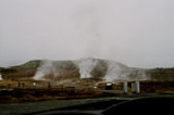
There are to be seen some of the most famous sights of the island: the geysers
Geyser
A geyser is a spring characterized by intermittent discharge of water ejected turbulently and accompanied by a vapour phase . The word geyser comes from Geysir, the name of an erupting spring at Haukadalur, Iceland; that name, in turn, comes from the Icelandic verb geysa, "to gush", the verb...
and other geothermal features which have developed on Laugarfjall rhyolitic
Rhyolite
This page is about a volcanic rock. For the ghost town see Rhyolite, Nevada, and for the satellite system, see Rhyolite/Aquacade.Rhyolite is an igneous, volcanic rock, of felsic composition . It may have any texture from glassy to aphanitic to porphyritic...
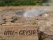
dome. The biggest geysers of Haukadalur are Strokkur
Strokkur
Strokkur is a fountain geyser in the geothermal area beside the Hvítá River in Iceland in the southwest part of the country, east of Reykjavik...
and Geysir
Geysir
Geysir , sometimes known as The Great Geysir, was the first geyser described in a printed source and the first known to modern Europeans. The English word geyser derives from Geysir. The name Geysir itself is derived from the Icelandic verb geysa, "to gush", the verb from Old Norse...
itself, which gave others their name. Strokkur is very dependable and erupts every 5 to 10 minutes, whereas the bigger Geysir only erupts 4 to 5 times a day. There are also more than 40 other little hot springs, mud pots and fumaroles nearby.
Haukadalur geothermal area was first mentioned in written sources in 1294, when the local hot springs were activated by earthquake. Earthquakes are known to activate local geysers also in the recent past, including 17th and 21st July 2000 earthquake. Due to geysers the valley has been the prime tourist attraction of Iceland since the 18th century.
The waterfall Gullfoss
Gullfoss
Gullfoss is a waterfall located in the canyon of Hvítá river in southwest Iceland.Gullfoss is one of the most popular tourist attractions in the country. The wide Hvítá rushes southward...
is about 10 km to the north in the direction of the Highlands of Iceland
Highlands of Iceland
The Highlands of Iceland cover most of the interior of Iceland. They are situated above 400–500 metres and are mostly an uninhabitable volcanic desert, because the water precipitating as rain or snow infiltrates so quickly into the ground that it is unavailable for plant growth, which results...
and at the beginning of the Kjölur
Kjölur
The Kjölur is a highland road in Iceland. It is the second longest of the roads through the Highlands of Iceland. It takes about 5 hours to traverse by car.- Geography :...
highland road. Like Þingvellir
Þingvellir
|Thing]] Fields) is a place in Bláskógabyggð in southwestern Iceland, near the peninsula of Reykjanes and the Hengill volcanic area. Þingvellir is a site of historical, cultural, and geological importance and is one of the most popular tourist destinations in Iceland. It is the site of a rift...
, Haukadalur is part of the Golden Circle
Golden Circle (Iceland)
The Golden Circle is a popular tourist route in South Iceland, covering about 300 km looping from Reykjavík into central Iceland and back.The three primary stops on the route are the national park Þingvellir, the waterfall Gullfoss , and the geothermally active valley of Haukadalur, which contains...
.
Haukadalur, Snæfellsnes
Another valley by the name Haukadalur exists in the north-west region of SnæfellsnesSnæfellsnes
The Snæfellsnes is a peninsula situated to the west of Borgarfjörður, in western of Iceland.It has been named Iceland in Miniature, as many national sights can be found in the area, including the Snæfellsjökull volcano, regarded as one of the symbols of Iceland. With its height of 1446 m, it...
. The valley is situated to the south of the village Búðardalur
Búðardalur
Búðardalur is a village situated on the Hvammsfjörður in the north-west of Iceland.The village also lies at the north-eastern end of the Snæfellsnes peninsula and is part of the municipality of Dalabyggð. Búðardalur has about 250 inhabitants and it is a service center for the area...
at 65°02′19"N 21°45′24"W. This is the location of the former residence of the viking
Viking
The term Viking is customarily used to refer to the Norse explorers, warriors, merchants, and pirates who raided, traded, explored and settled in wide areas of Europe, Asia and the North Atlantic islands from the late 8th to the mid-11th century.These Norsemen used their famed longships to...
Erik the Red
Erik the Red
Erik Thorvaldsson , known as Erik the Red , is remembered in medieval and Icelandic saga sources as having founded the first Nordic settlement in Greenland. The Icelandic tradition indicates that he was born in the Jæren district of Rogaland, Norway, as the son of Thorvald Asvaldsson, he therefore...
(isl. Eiríkur Rauði) who discovered Greenland
Greenland
Greenland is an autonomous country within the Kingdom of Denmark, located between the Arctic and Atlantic Oceans, east of the Canadian Arctic Archipelago. Though physiographically a part of the continent of North America, Greenland has been politically and culturally associated with Europe for...
.
Haukadalur, Vestfirðir
A third valley of this name is to be found near ÞingeyriÞingeyri
Thingeyri is a settlement in the municipality of Ísafjarðarbær, Iceland.It is located on the coats of the fjord Dýrafjörður in the mountainous peninsula Westfjords...
, in the Westfjords (Vestfirðir) at 65°52′8"N 23°29′48"W.