

Hartford, Providence, Rhode Island
Encyclopedia
Providence, Rhode Island
Providence is the capital and most populous city of Rhode Island and was one of the first cities established in the United States. Located in Providence County, it is the third largest city in the New England region...
, Rhode Island
Rhode Island
The state of Rhode Island and Providence Plantations, more commonly referred to as Rhode Island , is a state in the New England region of the United States. It is the smallest U.S. state by area...
. Route 6
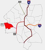
U.S. Route 6 in Rhode Island
U.S. Route 6 is a major east–west road in the U.S. state of Rhode Island. Nationally, the route continues west to Bishop, California and east to Provincetown, Massachusetts. In western Rhode Island, it forms part of one of several routes between Hartford, Connecticut and Providence, Rhode...
and the Woonasquatucket River
Woonasquatucket River
The Woonasquatucket River is a river in the U.S. state of Rhode Island. It flows approximately and drains a watershed of 130 km² ....
separate it from Olneyville.
History
Prior to the arrival of white settlers, the area had been used as a soapstone quarryQuarry
A quarry is a type of open-pit mine from which rock or minerals are extracted. Quarries are generally used for extracting building materials, such as dimension stone, construction aggregate, riprap, sand, and gravel. They are often collocated with concrete and asphalt plants due to the requirement...
by the Narragansett natives
Narragansett (tribe)
The Narragansett tribe are an Algonquian Native American tribe from Rhode Island. In 1983 they regained federal recognition as the Narragansett Indian Tribe of Rhode Island. In 2009, the United States Supreme Court ruled against their request that the Department of Interior take land into trust...
. The first white settlers were farmers. Throughout the seventeenth and eighteenth centuries, settlers built dwellings intended for temporary stays, though later, attracted by the country atmosphere, they adopted permanent residence.
In the early nineteenth century, the proximity of the Woonasquatucket River allowed the area to begin industrialization. In 1812 the Mill Merino became the second textile establishment in the general area, producing a soft material called "merino cloth". Merino Village, consisting of stone houses, a general store, and water supply, was built by the company to support its workers. As the area began to develop further, its economic opportunities attracted immigrants. Though initially primarily Irish, later waves of immigration brought Polish and later Italian immigrants to the neighborhood.
In the 1950s, massive projects altered the fabric of Hartford. The construction of Route 6 meant the demolition of a swath of working-class housing, while two large low-income housing projects (Hartford Park Public Housing Project and Manton Heights Housing Projects) visually demonstrated a shift in the neighborhood's demographics. As with much public housing in the United States
United States
The United States of America is a federal constitutional republic comprising fifty states and a federal district...
, both fell victim to neglect and vandalism, with the demolition of a significant number of units occurring in the 1980s.
Demographics
According to the 1990 census, three out of four residents in Hartford were white; about one in seven was Hispanic, nearly 10% were African American, and about 4% were Asian. True to Hartford's heritage, the largest fraction (27%) of employed residents work in manufacturing. The next largest fraction of employment (18%) was taken up by professional services. The unemployment rate for Hartford was 9.4% compared to city-wide average of 9.2%.According to the Providence Plan, a local nonprofit aimed at improving city life, today 48.4% of residents are Hispanic, 33.6% of residents are white, 10.6% are African-American, 5% are Asian, and nearly 2% are Native-American. 64% of children under the age of six speak a language other than English as their primary language.
The median family income is $28,065, below the city-wide average of $32,058. 40% of families live below the poverty line while 18% of residents receive some form of public assistance. 12% of children under the age of six have suffered from high lead exposure, below the city-wide average of 19%.
Government
Hartford is within Ward 7, which is represented in the Providence City CouncilProvidence City Council
The Providence City Council is the fifteen-member legislative body of the city of Providence, Rhode Island. The two major responsibilities of the council are enacting ordinances necessary to ensure the welfare and good order of the city and adopting the city's annual budget...
by Democrat John I. Igliozzi.
Parks
Merino Park is a 13.27 acres (53,701.8 m²) park on the banks of the Woonasquatucket RiverWoonasquatucket River
The Woonasquatucket River is a river in the U.S. state of Rhode Island. It flows approximately and drains a watershed of 130 km² ....
between Hartford Avenue and Route 6. It is the only large public park in Hartford.