

Haor
Encyclopedia

Wetland
A wetland is an area of land whose soil is saturated with water either permanently or seasonally. Wetlands are categorised by their characteristic vegetation, which is adapted to these unique soil conditions....
ecosystem
Ecosystem
An ecosystem is a biological environment consisting of all the organisms living in a particular area, as well as all the nonliving , physical components of the environment with which the organisms interact, such as air, soil, water and sunlight....
in the north eastern part of Bangladesh which physically is a bowl or saucer shaped shallow depression
Depression (geology)
A depression in geology is a landform sunken or depressed below the surrounding area. Depressions may be formed by various mechanisms.Structural or tectonic related:...
, also known as a backswamp
Backswamp
In geology backswamp is the section of a floodplain where deposits of fine silts and clays settle after a flood. Backswamps usually lie behind a stream's natural levees....
. In a country where one third of all area can be termed as wetlands, the haor basin is an internationally important wetland ecosystem, which is situated in Sunamganj
Sunamganj District
The district of Sunamganj consists 3562 mosques, 560 temples and 61 churches.-History:The name Sunamganj is derived from its founder, Sipahi Sunamuddin, who established a bazaar on the bank of the river Surma. In the ancient period, Sunamganj was part of the Rarh Kingdom that included Sylhet,...
, Habiganj
Habiganj District
Habiganj is a district in the north-eastern part of Bangladesh. It is under Sylhet Division.Habiganj is the historical place where the Mukti Bahini started their first guerrilla movement against aggressor Pakistani Army. It is also the place full of memory of Syed Nasir Uddin, an associate of...
and Moulvibazar districts and Sylhet Sadar Upazila
Sylhet Sadar Upazila
Sylhet Sadar is an Upazila of Sylhet District in the Division of Sylhet, Bangladesh.-Geography:Sylhet Sadar is located at . It has 86074 units of house hold and total area 517.43 km². The city of Sylhet is located within central of Sylhet Sadar....
, as well as Kishoreganj
Kishoreganj District
-Place of Interest:Kishorganj is a place of the creed of respectively Sanatana and Loukik Islam. Both Meghna and Brahmaputra river have contributed to its existence. Many traditional rituals are observed every year in Kishoreganj. Among them Kurikhai Mela is one of the most celebrated fair. It is a...
and Netrokona districts outside the core haor area. It is a mosaic of wetland habitats, including rivers, streams and irrigation canals, large areas of seasonally flooded cultivated plains, and hundreds of haors and beels. This zone contains about 400 haors and beels, varying in size from a few hectares to several thousand hectares.
Haor, baor, beel and jheel

Beel
A beel or a bheel is a term for a pond with static water , in the Ganges - Brahmaputra flood plains of the Eastern Indian states of West Bengal, and Assam and in the country of Bangladesh...
. All four are types of similar freshwater wetlands. The word haor is corrupted form of the Bengali
Bengali language
Bengali or Bangla is an eastern Indo-Aryan language. It is native to the region of eastern South Asia known as Bengal, which comprises present day Bangladesh, the Indian state of West Bengal, and parts of the Indian states of Tripura and Assam. It is written with the Bengali script...
word sagor (meaning sea) in regional dialect. In parts of Bangladesh, people often pronounce the Bengali alphabet স (sa) as হ (ha), and some times গ (ga) as হ (ha). In the pronunciation mix up sagor has become haor.
The line of difference between an haor, a beel and a baor is usually very thin. A beel is usually a depression or topographic low generally produced by erosion or other geographical process. These are generally smaller and seen all over Bangladesh. These are marshy in character. Sometimes beels are remains of a river that has changed its course. Many of the beels dry up in the winter but during the rains expand into broad and shallow sheets of water, which may be described as fresh water lagoons. Beels are generally smaller than haors, but there also are large beels like Chalan Beel
Chalan Beel
Chalan Beel is a wetland in Bangladesh. It is a large inland depression, marshy in character, with rich flora and fauna. Forty-seven rivers and other waterways flow into the Chalan Beel...
in Rajshahi Division, through which the Atrai River
Atrai River
Atrai River flows in West Bengal and northern parts of Bangladesh.In ancient times the river was called Atrei and finds a mention in the Mahabharata. It is linked with Karatoya River. It originates in West Bengal and then after flowing through Dinajpur District of Bangladesh, it enters India again...
passes. It has shrunk over the years but still occupies an area of 26 km² in dry season. Sometimes small permanent water bodies within the haors remain after the haors dry up. These are also called beels, which occupy the lowest part of the depressions.
A baor is an oxbow lake
Oxbow lake
An oxbow lake is a U-shaped body of water formed when a wide meander from the main stem of a river is cut off to create a lake. This landform is called an oxbow lake for the distinctive curved shape, named after part of a yoke for oxen. In Australia, an oxbow lake is called a billabong, derived...
, found mostly in the moribund delta as in greater Comilla
Comilla District
The district of Comilla consists 4543 mosques, 379 temples, 98 churches, 34 Buddhist temples and six tombs.-Places of interest:Important landmarks include Kotbari, a cantonment, or military installation and Kandirpar, considered the heart of the Comilla district...
, Faridpur
Faridpur District
Faridpur is a district in central Bangladesh. It is a part of the Dhaka Division. Faridpur District has a population of over 1.7 million people and is situated on the banks of the Padma river . It is bordered by Madaripur, Narail, Rajbari, Magura, Shariatpur, Gopalgonj, Dhaka and Manikganj...
, Dhaka
Dhaka District
Dhaka District is a district located in central Bangladesh, and is the densest district in the nation. It is a part of the Dhaka Division. Dhaka, the capital of Bangladesh, rests on the eastern banks of the Buriganga River which flows from the Turag to the south of the district...
and Pabna
Pabna District
Pabna District is a district in north-western Bangladesh. It is the southern most district of Rajshahi Division. Its administrative capital is eponymous Pabna town.-Geography:Pabna forms the south-east boundary of Rajshahi Division...
districts. The haor is predominantly a feature of north-eastern Bangladesh.
Geography and geology
The core haor area, alternatively referred to as the Haor basin or the Sylhet basin, is estimated to spread over an area between 4,450 km² and 25,000 square kilometres by experts. The total area of Haor-type wetland ecosystem in Bangladesh is 80,000 square kilometres. The haor basin is bounded by the hill ranges of India – MeghalayaMeghalaya
Meghalaya is a state in north-eastern India. The word "Meghalaya" literally means the Abode of Clouds in Sanskrit and other Indic languages. Meghalaya is a hilly strip in the eastern part of the country about 300 km long and 100 km wide, with a total area of about 8,700 sq mi . The...
on the north, Tripura
Tripura
Tripura is a state in North-East India, with an area of . It is the third smallest state of India, according to area. Tripura is surrounded by Bangladesh on the north, south, and west. The Indian states of Assam and Mizoram lie to the east. The capital is Agartala and the main languages spoken are...
and Mizoram
Mizoram
Mizoram is one of the Seven Sister States in North Eastern India, sharing borders with the states of Tripura, Assam, Manipur and with the neighbouring countries of Bangladesh and Burma. Mizoram became the 23rd state of India on 20 February 1987. Its capital is Aizawl. Mizoram is located in the...
on the south, and Assam
Assam
Assam , also, rarely, Assam Valley and formerly the Assam Province , is a northeastern state of India and is one of the most culturally and geographically distinct regions of the country...
and Manipur
Manipur
Manipur is a state in northeastern India, with the city of Imphal as its capital. Manipur is bounded by the Indian states of Nagaland to the north, Mizoram to the south and Assam to the west; it also borders Burma to the east. It covers an area of...
on the east. The basin extends north to the foot of the Garo and Khasia Hills, and east along the upper Surma Valley to the Indian border. The Tippera Surface lies directly to the south of the Haor Basin, and is partly low and deltaic and partly higher ground with a piedmont fringe to the east. It includes about 47 major haors and some 6,300 beels of varying size, of which about 3,500 are permanent and 2,800 are seasonal.
In the geological depression of the haor basin, subsidence
Subsidence
Subsidence is the motion of a surface as it shifts downward relative to a datum such as sea-level. The opposite of subsidence is uplift, which results in an increase in elevation...
is continuing at an estimated rate of 20 mm per year. In some places it has sunk by around 10 m in the last few hundred years. The area, by some experts, is further divided into three zones by standards of morphology
Geomorphology
Geomorphology is the scientific study of landforms and the processes that shape them...
and hydrology
Hydrology
Hydrology is the study of the movement, distribution, and quality of water on Earth and other planets, including the hydrologic cycle, water resources and environmental watershed sustainability...
:
- The piedmontPiedmontPiedmont is one of the 20 regions of Italy. It has an area of 25,402 square kilometres and a population of about 4.4 million. The capital of Piedmont is Turin. The main local language is Piedmontese. Occitan is also spoken by a minority in the Occitan Valleys situated in the Provinces of...
area: This area around the foothills is the most elevated zone. This area is treated as a accretionAccretion (coastal management)Accretion is the process of coastal sediment returning to the visible portion of a beach or foreshore following a submersion event. A sustainable beach or foreshore often goes through a cycle of submersion during rough weather then accretion during calmer periods...
zone where rapid siltationSiltationSiltation is the pollution of water by fine particulate terrestrial clastic material, with a particle size dominated by silt or clay. It refers both to the increased concentration of suspended sediments, and to the increased accumulation of fine sediments on bottoms where they are undesirable...
of coarser materials take place along the leveeLeveeA levee, levée, dike , embankment, floodbank or stopbank is an elongated naturally occurring ridge or artificially constructed fill or wall, which regulates water levels...
s by flashFlash floodA flash flood is a rapid flooding of geomorphic low-lying areas—washes, rivers, dry lakes and basins. It may be caused by heavy rain associated with a storm, hurricane, or tropical storm or meltwater from ice or snow flowing over ice sheets or snowfields...
y rivers due to the fall of gradient. Across the down-slope of levees lie the backswamp, acting as reservoir by storing water and substantially reducing flood peak at the downstream. - The floodplainFloodplainA floodplain, or flood plain, is a flat or nearly flat land adjacent a stream or river that stretches from the banks of its channel to the base of the enclosing valley walls and experiences flooding during periods of high discharge...
area: The floodplains, with milder slopes, are located at the middle of the basin. This zone receive sediments that is moderately finer in grade and considerably lower in volume. Backswamps along this section fill and drain several times in each monsoon, helping to reduce flood peak downstream. - The deeply flooded area: This deepest part of the wetlands is known more as the beel. During monsoon the beels and floodplains become deeply flooded and turn into a single water reservoir, especially in the SurmaSurma RiverThe Surma River is a major river in Bangladesh, part of the Surma-Meghna River System. It starts when the Barak River from northeast India divides at the Bangladesh border into the Surma and the Kushiyara rivers. It ends in Kishoreganj District, above Bhairab Bazar, where the two rivers rejoin to...
-KushiyaraKushiyara RiverThe Kushiyara River is one of the many rivers in Bangladesh that crosses international boundaries. It is a branch of the Barak River, which originates in the state of Manipur in India and runs along the border of the Indian states of Manipur & Mizoram before getting split into Surma and Kushiyara...
-MeghnaMeghna RiverThe Meghna River is an important river in Bangladesh, one of the three that forms the Ganges Delta, the largest on earth fanning out to the Bay of Bengal. Being a part of the Surma-Meghna River System, Meghna is formed inside Bangladesh by the joining of different rivers originaing from the hilly...
basin.
Soil within the same haor system can vary in texture, drainage class, fertility, and other parameters. This transition from the wettest to the driest areas in the floodplains occurs over distances varying from several kilometers to several meters.
Climate and floods

Monsoon
Monsoon is traditionally defined as a seasonal reversing wind accompanied by corresponding changes in precipitation, but is now used to describe seasonal changes in atmospheric circulation and precipitation associated with the asymmetric heating of land and sea...
. The climate of the area is subtropical monsoonal with an average annual rainfall of approximately 4,000 mm. Over 80% of the rain falls during the monsoon season from June to October. Temperatures normally vary between 26 and 31 °C in the pre-monsoon period (March to May), 28 to 31 °C in the rainy season, and 26 to 27 °C in winter.
Some of the most extensive seasonally flooded areas in South Asia
South Asia
South Asia, also known as Southern Asia, is the southern region of the Asian continent, which comprises the sub-Himalayan countries and, for some authorities , also includes the adjoining countries to the west and the east...
are situated in bowl-shaped depressions known as haors located between the natural levee
Levee
A levee, levée, dike , embankment, floodbank or stopbank is an elongated naturally occurring ridge or artificially constructed fill or wall, which regulates water levels...
s of rivers subject to overflow during the monsoon
Monsoon
Monsoon is traditionally defined as a seasonal reversing wind accompanied by corresponding changes in precipitation, but is now used to describe seasonal changes in atmospheric circulation and precipitation associated with the asymmetric heating of land and sea...
. The major rivers in the area are Surma
Surma River
The Surma River is a major river in Bangladesh, part of the Surma-Meghna River System. It starts when the Barak River from northeast India divides at the Bangladesh border into the Surma and the Kushiyara rivers. It ends in Kishoreganj District, above Bhairab Bazar, where the two rivers rejoin to...
and Kushiyara
Kushiyara River
The Kushiyara River is one of the many rivers in Bangladesh that crosses international boundaries. It is a branch of the Barak River, which originates in the state of Manipur in India and runs along the border of the Indian states of Manipur & Mizoram before getting split into Surma and Kushiyara...
. Some of the tributaries are: Manu, Khowai, Jadukhata, Piyain, Mogra, Mahadao and Kangsha. These form the dense drainage network of the haors. The rivers are primarily responsible for providing inputs - rainwater and sediment load to the basin. The hilly rivers coming down from the Khasi and Jaintia hills in Meghalaya carry particularly high volumes of water as they come from some of the rainiest places in the world.
During July to November due to flood these areas go under deep water and look like seas with erosive water surface. During wind storm these waves reach up to 1.5 m in height. It remains under water for seven months of the year, turning haor settlements mostly built on earthen mounds into islands. During the dry season most of the water drains out, leaving small shallow lakes or may completely dry out by the end of dry season. This exposes rich alluvial soil, extensively cultivated for rice.
The fight against natural calamity of the locals people, mostly day laborers, relies on traditional and indigenous methods which with limited effect. Many villages have already been washed away, and many more are on the verge of extinction, forcing people to migrate to urban centers.
Environment
Compared with other major natural forms of landscape, a wetland is young, dynamic and physically unstable. Variously called jalah, doloni, pitoni, doba, hola or gadeng, it can change in a season or even in a single storm, as conditions range from virtually perennial aquatic lowlands to seasonally dry uplands. It changes with the vegetationVegetation
Vegetation is a general term for the plant life of a region; it refers to the ground cover provided by plants. It is a general term, without specific reference to particular taxa, life forms, structure, spatial extent, or any other specific botanical or geographic characteristics. It is broader...
, sedimentation
Sedimentation
Sedimentation is the tendency for particles in suspension to settle out of the fluid in which they are entrained, and come to rest against a barrier. This is due to their motion through the fluid in response to the forces acting on them: these forces can be due to gravity, centrifugal acceleration...
, or geological subsidence. The key to vegetation development and community dynamics here is hydroperiod, affected by topography, flooding and flood type, precipitation, and water table fluctuations.
Due to continuous submergence, wetland habitat is characterized by anaerobic conditions which inhibits normal plant growth apart from a group of plants known as hydrophytes are adapted to withstand these conditions. The Haor Basin is the only region in Bangladesh where remnant patches of freshwater swamp
Swamp
A swamp is a wetland with some flooding of large areas of land by shallow bodies of water. A swamp generally has a large number of hammocks, or dry-land protrusions, covered by aquatic vegetation, or vegetation that tolerates periodical inundation. The two main types of swamp are "true" or swamp...
s and reed lands still exists. Once extensive forests of Hijal in the area used to provide an important source of firewood, but these forests are now almost completely destroyed. In recent times, various herbs and aquatic plants are being collected for use as fuel. On top of that, aquatic plants are also being collected for use as fertilizers. Only a few patches remain of the swamp forests that once dominated the area, featuring flood tolerant trees like Hijal (Barringtonia acutangula
Barringtonia acutangula
Barringtonia acutangula is a species of Barringtonia native to coastal wetlands in southern Asia and northern Australasia, from Afghanistan east to the Philippines and Queensland.-Medicinal Uses:Antitumor Antibiotic...
) and Koroch (Ponogamia pinnata).
Joseph Dalton Hooker
Joseph Dalton Hooker
Sir Joseph Dalton Hooker OM, GCSI, CB, MD, FRS was one of the greatest British botanists and explorers of the 19th century. Hooker was a founder of geographical botany, and Charles Darwin's closest friend...
(1817-1911) did the original survey of local flora on his way back to Kolkata
Kolkata
Kolkata , formerly known as Calcutta, is the capital of the Indian state of West Bengal. Located on the east bank of the Hooghly River, it was the commercial capital of East India...
from his survey of the flora of the region, recorded in his Himalayan Journals, sometime in 1850 (published by the Calcutta Trigonometrical Survey
Great Trigonometric Survey
The Great Trigonometric Survey was a project of the Survey of India throughout most of the 19th century. It was piloted in its initial stages by William Lambton, and later by George Everest. Among the many accomplishments of the Survey were the demarcation of the British territories in India and...
Office and (The Minerva Library of Famous Books; Ward, Lock, Bowden & Co., 1891). The findings of his travels along the Surma and visited the wetlands of Sylhet is reflected in the Flora of British India. Three habitat types in the Sylhet region were identified on the basis of a collation of systematic botanical records of Kanjilal (U.N. Kanjilal, P.C. Kanjilal & A. Das; Flora of Assam; 1934):
- Upland vegetation: Plants at the beel fringe and at all higher levels, including Crataeva, Terminalia, Lagerstroemia, Ardisia, Trewia, Ficus and Clinogyne.
- GrasslandGrasslandGrasslands are areas where the vegetation is dominated by grasses and other herbaceous plants . However, sedge and rush families can also be found. Grasslands occur naturally on all continents except Antarctica...
: Emergent vegetation, including Hygroryza, Panicum, Phragmites, and Arundo. - Aquatic vegetation: These includes Nymphaeaceae, Araceae, Lemnaceae, Alismataceae, Najadaceae, Eriocaulaceae and Cyperaceae.
The Hijal or Hual, Korij or Koroch, Bhui Dumur (Ficus heterophyllus), Nol (Arundo donax
Arundo donax
Arundo donax, Giant Cane, is a tall perennial cane growing in damp soils, either fresh or moderately saline. Other common names include Carrizo, Arundo, Spanish cane, Wild cane, and Giant reed....
), Khagra (Pharagmites karka), Ban Golap (Rosa involucratia) and Barun (Crataeva nurvala) are the main plant species found in the swamp forests. All of them are flood-tolerant species and can survive in the submerged condition for extended periods of time. However, among these, hijal, tamal and koroj trees are of the greatest value to the people and the environment. Other plant species available in Bangladesh wetlands include Madar (Erythrina variegata
Erythrina variegata
Erythrina variegata is a species of Erythrina native to the tropical and subtropical regions of eastern Africa, the Indian Subcontinent, northern Australia, and the islands of the Indian Ocean and the western Pacific Ocean east to...
), Gab (Diospyros peregrina), Makna (Euryale ferox
Euryale ferox
Euryale ferox is the only species in the genus Euryale. It is a flowering plant classified in the water lily family, Nymphaeaceae, although it is occasionally regarded as a distinct family Euryalaceae...
), Singara (Trapa bispinosa), Jaldumur (a kind of Ficus
Ficus
Ficus is a genus of about 850 species of woody trees, shrubs, vines, epiphytes, and hemiepiphyte in the family Moraceae. Collectively known as fig trees or figs, they are native throughout the tropics with a few species extending into the semi-warm temperate zone. The Common Fig Ficus is a genus of...
), Chitki (Phyllanthus reticulatus), Thankuni (Centella asiatica
Centella asiatica
Centella asiatica is a small herbaceous annual plant of the family Mackinlayaceae or subfamily Mackinlayoideae of family Apiaceae, and is native to India, Sri Lanka, northern Australia, Indonesia, Iran, Malaysia, Melanesia, Papua New Guinea, and other parts of Asia...
), Kalmi (Ipomoea aquatica
Ipomoea aquatica
Ipomoea aquatica is a semi-aquatic tropical plant grown as a leaf vegetable. It is known in English as Water Spinach, Water Morning Glory, Water Convolvulus, or by the more ambiguous names "Chinese spinach" and "swamp cabbage". It has many other names in other languages, such as "Phak bung" in Thai...
), Helencha (Enhydra flactuans), Hogla (Typha elephantina), duckweed, water hyacinth
Water hyacinth
The seven species of water hyacinth comprise the genus Eichhornia. Water hyacinth are a free-floating perennial aquatic plant native to tropical and sub-tropical South America. With broad, thick, glossy, ovate leaves, water hyacinth may rise above the surface of the water as much as 1 meter in...
, lotus
Lotus (plant)
Lotus identifies various plant taxa:* Nelumbo, a genus of aquatic plants with showy flowers** Nelumbo nucifera, the Sacred or Indian lotus** Nelumbo lutea, the American or Yellow lotus...
and water lily
Nymphaeaceae
Nymphaeaceae is a family of flowering plants. Members of this family are commonly called water lilies and live in freshwater areas in temperate and tropical climates around the world. The family contains eight genera. There are about 70 species of water lilies around the world. The genus...
.
Eight plant communities have identified in the haor area (number of species in parentheses): submerged plants (20), free floating plants (15), rooted floating plants (15), sedges and meadows (35), floodplain grassland, reed swamp (7), fresh water swamp forest (7), crop field vegetation (60), and homestead vegetation (63).
The extinct fauna of the area includes a few species that are included in the IUCN Red Data Book as highly endangered species, including One-horned Rhinoceros (Rhinoceros unicornis), Swamp Deer (Cervus duvauceli), Hispid Hare (Caprolagus hispidus), Swamp Partridge (Francolinus gularis), Bengal Florican (Eupodotis bengalensis) and Marsh Babbler (Pellorneum palustre).
Conservation
The international significance of the wetlands of the haor basin for their waterfowlWaterfowl
Waterfowl are certain wildfowl of the order Anseriformes, especially members of the family Anatidae, which includes ducks, geese, and swans....
populations was first drawn to the attention of the international conservation community at an International Regional Meeting on Conservation of Wildfowl Resources held in Saint Petersburg
Saint Petersburg
Saint Petersburg is a city and a federal subject of Russia located on the Neva River at the head of the Gulf of Finland on the Baltic Sea...
in September 1968. The Directory of Asian Wetlands (Scott, 1989), based on studies conducted by Abdul Wahab Akonda of the Forest Department, and by S.M.A. Rashid and Raguib Uddin Ahmed of the Wildlife Society of Bangladesh, identifies the wetlands of the haor basin, including ten key sites, of Sylhet and Mymensingh as a wetland ecosystem of outstanding international importance. Six of these key sites - Tanguar haor, Pashua beel and Gurmar haor, Hakaluki haor, Hail haor, Kawadighi haor, Balai haor - has been identified by Bangladesh Flood Action Plan as of outstanding national and international importance.
Three zones of international importance for conservation and sustainable utilization - the Meghna estuary
Meghna River
The Meghna River is an important river in Bangladesh, one of the three that forms the Ganges Delta, the largest on earth fanning out to the Bay of Bengal. Being a part of the Surma-Meghna River System, Meghna is formed inside Bangladesh by the joining of different rivers originaing from the hilly...
, Tanguar haor
Tanguar haor
Tanguar haor , , located in the Dharmapasha and Tahirpur upazilas of Sunamganj District in Bangladesh, is a unique wetland ecosystem of national importance and has come into international focus. The area of Tanguar haor including 46 villages within the haor is about 100km2 of which 2,802.36 ha2 is...
and Hail-Hakaluki haor
Hakaluki haor
Hakaluki Haor is a marsh wetland ecological system of Eastern Bangladesh in an area bordering Assam, India. It is one of Bangladesh's largest and one of Asia's larger marsh wetland resources...
s - have been declared as Ramsar sites under the Ramsar Convention
Ramsar Convention
The Ramsar Convention is an international treaty for the conservation and sustainable utilization of wetlands, i.e., to stem the progressive encroachment on and loss of wetlands now and in the future, recognizing the fundamental ecological functions of wetlands and their economic, cultural,...
for protection of wetlands, of which Bangladesh is a signatory. The Bangladesh government has also declared the Tnaguar haor an Ecologically Critical Area
Ecologically Critical Area
Ecologically Critical Area is an environmental protection zone in Bangladesh.Gulshan-Baridhara Lake was declared an ECA in 2001. In September 2009, the four rivers around the capital city Dhaka - Buriganga River, Shitalakshya River, Turag River and Balu River -- have been declared by the...
. The Haor basin has a number of government bodies working to preserve the environment, including the Forest Resources Management Project, Management of Aquatic Ecosystem through Community Husbandry (MACH), Haor and Floodplain Resource, Conservation and Management of Medicinal Plants and Coastal and Wetland Biodiversity Management at Cox’s Bazar and Hakaluki Haor(CWBMP).
Migratory birds
About 207 species of birds live or visit Bangladesh. Among the birds 30% are waterfowls, 26% waders, 20% bush and her bland birds and the rest are grassland, air hawking prey. Of these fresh water birds 129 species (62.3 %) are resident and the other are migratory. The list of extinct wetland birds include spotbill pelican, pelican, scavenger vulture, Bengal florican, pinkheaded duck, greater adjutant and king vulture. There are several endangered species. Poachers pose the biggest danger to migratory birds. Although the Wildlife Preservation Act prohibits the hunting of migratory birds and wild animals, the law is not being implemented. Open sales of wild and migratory birds in the cities are all too flagrant. Guest birds trapped in Sylhet's haors are held captive in Srimangal town for sale in other cities. The poachers take advantage of the people’s lack of awareness of the importance of migratory birds.While poaching, killing of birds, and their open sale in towns continues, it would be wrong to say that in Bangladesh there is no place where birds are safe from harm. In Kanglar haor in Sunamganj, guest birds are neither shot nor caught. Near the haor is the Birampur village, where people understand that as part of Mother Nature guest birds need to be cherished, not hunted. The local panchayet in this village banned the killing of birds in 2001. The initiative to save the birds was taken by Abdus Samad, an elderly villager, whose step has become a united move worthy of replication.
Human habitation

It is believed that the early settlers of the area were Hindus and other ethnic groups including Garo
Garo
-Garo People and languages :* Garo , a tribe in India and Bangladesh.* Bodo-Garo languages, a small family of Tibeto-Burman languages spoken in eastern India,** Garo language, the language spoken by the Garo tribe...
, Hajong
Hajong
The Hajong is a tribal ethnic group in the Indian Subcontinent & four major Tribe in Meghalaya. Hajong people are spread out across northeast India and Bangladesh. At present their population is more than 100,000 in India and 30,000 in Bangladesh. Hajongs are predominantly rice farmers although...
, Khasi and Koch
Koch
Koch may refer to:* Koch , a type of Arctic boat* Koch people , an ethnic group originally from the ancient Koch kingdom in north east India* Koch , people with this surname* Koch, Łódź Voivodeship, a village in central Poland...
people coming down from the hills to the north. They were drawn to the area because of its productivity and favorable tenurial terms
Land tenure
Land tenure is the name given, particularly in common law systems, to the legal regime in which land is owned by an individual, who is said to "hold" the land . The sovereign monarch, known as The Crown, held land in its own right. All private owners are either its tenants or sub-tenants...
. With the expansion of Muslim power in the south and the west further Hindu migration continued in the 13th and 14th century. Following an Afghan defeat in Orissa in 1592, a large number of Afghans moved into the area. Expansion of Muslim population continued after the Muslim conquest of Sylhet in 1612, accelerating after the British conquest of Sylhet in 1765. By 1770s all the cultivable land was brought under plough cultivation.
From the 1780s, population and area under cultivation declined till early 20th century, mostly due to successive natural calamities including floods and earthquakes. The haor basin became an important fishing zone during this time. Population growth picked up again in the 20th century, again due to the opportunity to cultivate land for a nominal rent.
Economy
Haors and baors, along with the rivers, canals and the floodplain, are a major source of fish production. But, due to siltation, and harvesting of excessive amounts of fish to
meet the demand of growing populations production of fish from this source is gradually dwindling. In recent years, the wetlands have also been used for rearing domestic ducks.
Due to scarcity of cultivable land, government lands (Khas land) including the wetlands are increasing getting transferred to private ownership in Bangladesh. Thus most of the haors and beels have now been sold or leased to private individuals for cultivation during the dry season. This transfer is governed by the Haor Development Board Ordinance (Ordinance No. IX of 1977) are under the direct control of the Revenue Department in the Ministry of Land Administration and Land Reforms.
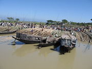
Tourism
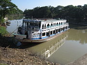
Lonely Planet describes these areas as "some of the most fascinating rural areas of Bangladesh."