

Hancock County, Illinois
Encyclopedia
Hancock County is a county located in the U.S. state
of Illinois
. According to the 2010 census, it has a population of 19,104, which is a decrease of 5.1% from 20,121 in 2000. Its county seat
is Carthage
. Hamilton
is the largest city in Hancock County, with Carthage being the second largest. The county is made up of rural towns with many farmers.
set aside by Congress to reward veterans of the War of 1812
. Actual settlement of the interior of the County was delayed by concerns about hostile American Indians. After their defeat in the Blackhawk War in 1832, settlement proceeded quickly.
Hancock County was formed, on January 13, 1825, out of Pike County
. It was named in honor of John Hancock
, who clearly signed the Declaration of Independence
.
For a brief period in the 1840s Hancock had one of Illinois' most populous cities: Nauvoo
, which was then headquarters for the Church of Jesus Christ of Latter Day Saints. The LDS leader Joseph Smith, Jr. was killed
in the county seat of Carthage in 1844. Most Mormons
left Hancock county in the 1840s. Today followers of the LDS movement come, in increasing numbers, to important LDS sites in Hancock county, partly for vacation and partly for religious pilgrimage.
The original courthouse was located at Montebello. Montebello no longer exists but was between Nauvoo and Hamilton. In 1833 the state commissioned the formation of the county seat at Carthage IL which was centrally located but not well developed at the time. A log cabin was built to serve as the courthouse and continued to serve that purpose until 1839 when the second Carthage Courthouse was built. The original log cabin continued to serve as a school and other purposes until 1945 when it was removed.
The second courthouse cost $3,700 dollars to build and served from 1839 until 1906. It served as a location for both Stephan A. Douglas (October 11, 1858) and Abraham Lincoln (October 22, 1858) to speak to residents of the area as they were running against each other for the US Senate. In 1906 it was removed to make room for the current courthouse.
The current courthouse was dedicated October 21, 1908.
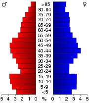
As of the census
of 2000, there were 20,121 people, 8,069 households, and 5,607 families residing in the county. The population density
was 25 people per square mile (10/km²). There were 8,909 housing units at an average density of 11 per square mile (4/km²). The racial makeup of the county was 98.68% White
, 0.20% Black
or African American
, 0.18% Native American
, 0.23% Asian
, 0.02% Pacific Islander
, 0.13% from other races
, and 0.56% from two or more races. 0.52% of the population were Hispanic
or Latino
of any race. 35.5% were of German
, 20.7% American
, 12.0% English
and 10.0% Irish
ancestry according to Census 2000. 98.8% spoke English
and 1.0% Spanish
as their first language.
There were 8,069 households out of which 30.50% had children under the age of 18 living with them, 58.90% were married couples
living together, 7.60% had a female householder with no husband present, and 30.50% were non-families. 26.90% of all households were made up of individuals and 13.80% had someone living alone who was 65 years of age or older. The average household size was 2.45 and the average family size was 2.96.
In the county the population was spread out with 24.60% under the age of 18, 7.10% from 18 to 24, 25.50% from 25 to 44, 24.50% from 45 to 64, and 18.30% who were 65 years of age or older. The median age was 40 years. For every 100 females there were 94.20 males. For every 100 females age 18 and over, there were 90.20 males.
The median income for a household in the county was $36,654, and the median income for a family was $44,457. Males had a median income of $31,095 versus $20,680 for females. The per capita income
for the county was $17,478. About 5.40% of families and 8.30% of the population were below the poverty line, including 9.90% of those under age 18 and 8.20% of those age 65 or over.
:
U.S. state
A U.S. state is any one of the 50 federated states of the United States of America that share sovereignty with the federal government. Because of this shared sovereignty, an American is a citizen both of the federal entity and of his or her state of domicile. Four states use the official title of...
of Illinois
Illinois
Illinois is the fifth-most populous state of the United States of America, and is often noted for being a microcosm of the entire country. With Chicago in the northeast, small industrial cities and great agricultural productivity in central and northern Illinois, and natural resources like coal,...
. According to the 2010 census, it has a population of 19,104, which is a decrease of 5.1% from 20,121 in 2000. Its county seat
County seat
A county seat is an administrative center, or seat of government, for a county or civil parish. The term is primarily used in the United States....
is Carthage
Carthage, Illinois
Carthage is a city in Hancock County, Illinois, United States. The population was 2,725 at the 2000 census. It is the county seat of Hancock County. Carthage is most famous for being the site of the murder of Joseph Smith in 1844.- History :...
. Hamilton
Hamilton, Illinois
Hamilton is a city in Hancock County, Illinois, United States. The population was 3,029 at the 2000 census. The city is located directly across the Mississippi River from Keokuk, Iowa. Hamilton is the largest city in Hancock County.-About Hamilton:...
is the largest city in Hancock County, with Carthage being the second largest. The county is made up of rural towns with many farmers.
History
Hancock County was part of the "Military Tract"Military Tract of 1812
In May 1812, an act of Congress was passed which set aside bounty lands as payment to volunteer soldiers for the War against the British...
set aside by Congress to reward veterans of the War of 1812
War of 1812
The War of 1812 was a military conflict fought between the forces of the United States of America and those of the British Empire. The Americans declared war in 1812 for several reasons, including trade restrictions because of Britain's ongoing war with France, impressment of American merchant...
. Actual settlement of the interior of the County was delayed by concerns about hostile American Indians. After their defeat in the Blackhawk War in 1832, settlement proceeded quickly.
Hancock County was formed, on January 13, 1825, out of Pike County
Pike County, Illinois
Pike County is a county located in the U.S. state of Illinois. According to the 2010 census, it has a population of 16,430, which is a decrease of 5.5% from 17,384 in 2000...
. It was named in honor of John Hancock
John Hancock
John Hancock was a merchant, statesman, and prominent Patriot of the American Revolution. He served as president of the Second Continental Congress and was the first and third Governor of the Commonwealth of Massachusetts...
, who clearly signed the Declaration of Independence
Declaration of independence
A declaration of independence is an assertion of the independence of an aspiring state or states. Such places are usually declared from part or all of the territory of another nation or failed nation, or are breakaway territories from within the larger state...
.
For a brief period in the 1840s Hancock had one of Illinois' most populous cities: Nauvoo
Nauvoo, Illinois
Nauvoo is a small city in Hancock County, Illinois, United States. Although the population was just 1,063 at the 2000 census, and despite being difficult to reach due to its location in a remote corner of Illinois, Nauvoo attracts large numbers of visitors for its historic importance and its...
, which was then headquarters for the Church of Jesus Christ of Latter Day Saints. The LDS leader Joseph Smith, Jr. was killed
Death of Joseph Smith, Jr.
The death of Joseph Smith, Jr. on June 27, 1844 marked a turning point for the Latter Day Saint movement, of which Smith was the founder and leader. When he was attacked and killed by a mob, Smith was the mayor of Nauvoo, Illinois, and running for President of the United States...
in the county seat of Carthage in 1844. Most Mormons
Mormons
The Mormons are a religious and cultural group related to Mormonism, a religion started by Joseph Smith during the American Second Great Awakening. A vast majority of Mormons are members of The Church of Jesus Christ of Latter-day Saints while a minority are members of other independent churches....
left Hancock county in the 1840s. Today followers of the LDS movement come, in increasing numbers, to important LDS sites in Hancock county, partly for vacation and partly for religious pilgrimage.
The original courthouse was located at Montebello. Montebello no longer exists but was between Nauvoo and Hamilton. In 1833 the state commissioned the formation of the county seat at Carthage IL which was centrally located but not well developed at the time. A log cabin was built to serve as the courthouse and continued to serve that purpose until 1839 when the second Carthage Courthouse was built. The original log cabin continued to serve as a school and other purposes until 1945 when it was removed.
The second courthouse cost $3,700 dollars to build and served from 1839 until 1906. It served as a location for both Stephan A. Douglas (October 11, 1858) and Abraham Lincoln (October 22, 1858) to speak to residents of the area as they were running against each other for the US Senate. In 1906 it was removed to make room for the current courthouse.
The current courthouse was dedicated October 21, 1908.
Geography
According to the 2010 census, the county has a total area of 814.4 square miles (2,109.3 km²), of which 793.73 square miles (2,055.8 km²) (or 97.46%) is land and 20.67 square miles (53.5 km²) (or 2.54%) is water.Major highways
 U.S. Highway 136


Adjacent Counties
- Henderson County - northeast
- McDonough County - east
- Schuyler County - southeast
- Adams CountyAdams County, IllinoisAdams County is the westernmost county of the U.S. state of Illinois. According to the 2010 census, it has a population of 67,103, which is a decrease of 1.7% from 68,277 in 2000...
- south - Lewis County, Missouri - southwest
- Clark County, MissouriClark County, MissouriClark County is a county located in the U.S. state of Missouri. As of 2010, the population was 7,139. Its county seat is Kahoka. The county was organized in 1836 and named after William Clark, leader of the Lewis and Clark Expedition and later a Governor of Missouri Territory.Clark County is part...
- west - Lee County, IowaLee County, Iowa-2010 census:The 2010 census recorded a population of 35,862 in the county, with a population density of . There were 16,205 housing units, of which 14,610 were occupied.-2000 census:...
- northwest
Demographics
As of the census
Census
A census is the procedure of systematically acquiring and recording information about the members of a given population. It is a regularly occurring and official count of a particular population. The term is used mostly in connection with national population and housing censuses; other common...
of 2000, there were 20,121 people, 8,069 households, and 5,607 families residing in the county. The population density
Population density
Population density is a measurement of population per unit area or unit volume. It is frequently applied to living organisms, and particularly to humans...
was 25 people per square mile (10/km²). There were 8,909 housing units at an average density of 11 per square mile (4/km²). The racial makeup of the county was 98.68% White
Race (United States Census)
Race and ethnicity in the United States Census, as defined by the Federal Office of Management and Budget and the United States Census Bureau, are self-identification data items in which residents choose the race or races with which they most closely identify, and indicate whether or not they are...
, 0.20% Black
Race (United States Census)
Race and ethnicity in the United States Census, as defined by the Federal Office of Management and Budget and the United States Census Bureau, are self-identification data items in which residents choose the race or races with which they most closely identify, and indicate whether or not they are...
or African American
Race (United States Census)
Race and ethnicity in the United States Census, as defined by the Federal Office of Management and Budget and the United States Census Bureau, are self-identification data items in which residents choose the race or races with which they most closely identify, and indicate whether or not they are...
, 0.18% Native American
Race (United States Census)
Race and ethnicity in the United States Census, as defined by the Federal Office of Management and Budget and the United States Census Bureau, are self-identification data items in which residents choose the race or races with which they most closely identify, and indicate whether or not they are...
, 0.23% Asian
Race (United States Census)
Race and ethnicity in the United States Census, as defined by the Federal Office of Management and Budget and the United States Census Bureau, are self-identification data items in which residents choose the race or races with which they most closely identify, and indicate whether or not they are...
, 0.02% Pacific Islander
Race (United States Census)
Race and ethnicity in the United States Census, as defined by the Federal Office of Management and Budget and the United States Census Bureau, are self-identification data items in which residents choose the race or races with which they most closely identify, and indicate whether or not they are...
, 0.13% from other races
Race (United States Census)
Race and ethnicity in the United States Census, as defined by the Federal Office of Management and Budget and the United States Census Bureau, are self-identification data items in which residents choose the race or races with which they most closely identify, and indicate whether or not they are...
, and 0.56% from two or more races. 0.52% of the population were Hispanic
Race (United States Census)
Race and ethnicity in the United States Census, as defined by the Federal Office of Management and Budget and the United States Census Bureau, are self-identification data items in which residents choose the race or races with which they most closely identify, and indicate whether or not they are...
or Latino
Race (United States Census)
Race and ethnicity in the United States Census, as defined by the Federal Office of Management and Budget and the United States Census Bureau, are self-identification data items in which residents choose the race or races with which they most closely identify, and indicate whether or not they are...
of any race. 35.5% were of German
Germans
The Germans are a Germanic ethnic group native to Central Europe. The English term Germans has referred to the German-speaking population of the Holy Roman Empire since the Late Middle Ages....
, 20.7% American
United States
The United States of America is a federal constitutional republic comprising fifty states and a federal district...
, 12.0% English
English people
The English are a nation and ethnic group native to England, who speak English. The English identity is of early mediaeval origin, when they were known in Old English as the Anglecynn. England is now a country of the United Kingdom, and the majority of English people in England are British Citizens...
and 10.0% Irish
Irish people
The Irish people are an ethnic group who originate in Ireland, an island in northwestern Europe. Ireland has been populated for around 9,000 years , with the Irish people's earliest ancestors recorded having legends of being descended from groups such as the Nemedians, Fomorians, Fir Bolg, Tuatha...
ancestry according to Census 2000. 98.8% spoke English
English language
English is a West Germanic language that arose in the Anglo-Saxon kingdoms of England and spread into what was to become south-east Scotland under the influence of the Anglian medieval kingdom of Northumbria...
and 1.0% Spanish
Spanish language
Spanish , also known as Castilian , is a Romance language in the Ibero-Romance group that evolved from several languages and dialects in central-northern Iberia around the 9th century and gradually spread with the expansion of the Kingdom of Castile into central and southern Iberia during the...
as their first language.
There were 8,069 households out of which 30.50% had children under the age of 18 living with them, 58.90% were married couples
Marriage
Marriage is a social union or legal contract between people that creates kinship. It is an institution in which interpersonal relationships, usually intimate and sexual, are acknowledged in a variety of ways, depending on the culture or subculture in which it is found...
living together, 7.60% had a female householder with no husband present, and 30.50% were non-families. 26.90% of all households were made up of individuals and 13.80% had someone living alone who was 65 years of age or older. The average household size was 2.45 and the average family size was 2.96.
In the county the population was spread out with 24.60% under the age of 18, 7.10% from 18 to 24, 25.50% from 25 to 44, 24.50% from 45 to 64, and 18.30% who were 65 years of age or older. The median age was 40 years. For every 100 females there were 94.20 males. For every 100 females age 18 and over, there were 90.20 males.
The median income for a household in the county was $36,654, and the median income for a family was $44,457. Males had a median income of $31,095 versus $20,680 for females. The per capita income
Per capita income
Per capita income or income per person is a measure of mean income within an economic aggregate, such as a country or city. It is calculated by taking a measure of all sources of income in the aggregate and dividing it by the total population...
for the county was $17,478. About 5.40% of families and 8.30% of the population were below the poverty line, including 9.90% of those under age 18 and 8.20% of those age 65 or over.
Cities and towns
- AugustaAugusta, IllinoisAugusta is a village in Hancock County, Illinois, United States. The population was 657 at the 2000 census. It is located near Weinberg-King State Park.- Geography :Augusta is located at ....
- BascoBasco, IllinoisBasco is a village in Hancock County, Illinois, U.S.- Geography :Basco is located at .According to the United States Census Bureau, the village has a total area of , all of it land.- Demographics :...
- BentleyBentley, IllinoisBentley is a village in Hancock County, Illinois, United States. The population was 43 at the 2000 census.-Geography:Bentley is located at ....
- BowenBowen, IllinoisBowen is a village in Hancock County, Illinois, United States. The population was 535 at the 2000 census.-Geography:Bowen is located at ....
- CarthageCarthage, IllinoisCarthage is a city in Hancock County, Illinois, United States. The population was 2,725 at the 2000 census. It is the county seat of Hancock County. Carthage is most famous for being the site of the murder of Joseph Smith in 1844.- History :...
- Dallas CityDallas City, IllinoisDallas City is a city in Hancock and Henderson counties in the U.S. state of Illinois. The population was 1,055 at the 2000 census.The Henderson County portion of Dallas City is part of the Burlington, IA–IL Micropolitan Statistical Area.-Geography:...
(partly in Henderson County) - ElvastonElvaston, IllinoisElvaston is a village in Hancock County, Illinois, United States. The population was 152 at the 2000 census.-Geography:Elvaston is located at ....
- FerrisFerris, IllinoisFerris is a village in Hancock County, Illinois, United States. The population was 168 at the 2000 census.-Geography:Ferris is located at ....
- Fountain GreenFountain Green, IllinoisFountain Green, Illinois, is an unincorporated community located about eleven miles northeast of Carthage, Illinois in Fountain Green Township, Hancock County, Illinois, USA.-Geography:Fountain Green is located at at an elevation of 682 feet.-History:...
- HamiltonHamilton, IllinoisHamilton is a city in Hancock County, Illinois, United States. The population was 3,029 at the 2000 census. The city is located directly across the Mississippi River from Keokuk, Iowa. Hamilton is the largest city in Hancock County.-About Hamilton:...
- La HarpeLa Harpe, IllinoisLa Harpe is a city in Hancock County, Illinois, United States. The population was 1,385 at the 2000 census.-Geography:La Harpe is located at , along the South Branch La Moine River....
- NauvooNauvoo, IllinoisNauvoo is a small city in Hancock County, Illinois, United States. Although the population was just 1,063 at the 2000 census, and despite being difficult to reach due to its location in a remote corner of Illinois, Nauvoo attracts large numbers of visitors for its historic importance and its...
- PlymouthPlymouth, IllinoisPlymouth is a village in Hancock County, Illinois, United States. The population was 562 at the 2000 census.-Geography:Plymouth is located at .According to the United States Census Bureau, the village has a total area of , all of it land.-Demographics:...
- PontoosucPontoosuc, IllinoisPontoosuc is a village in Hancock County, Illinois, United States. The population was 171 at the 2000 census.-Geography:Pontoosuc is located at ....
- WarsawWarsaw, IllinoisWarsaw is a city in Hancock County, Illinois, United States. The population was 1,793 at the 2000 census. The city is notable for its historic downtown and the Warsaw Brewery, which operated for more than 100 years beginning in 1861...
- West PointWest Point, IllinoisWest Point is a village in Hancock County, Illinois, United States. The population was 195 at the 2000 census.-Geography:West Point is located at .According to the United States Census Bureau, the village has a total area of , all of it land....
Unincorporated towns
- AdrianAdrian, IllinoisAdrian is an unincorporated town in Rock Creek Township, Hancock County, Illinois, USA.-Geography:Adrian is located at at an elevation of 699 feet....
- BurnsideBurnside, IllinoisBurnside is an unincorporated town in Pilot Grove Township, Hancock County, Illinois, USA.-Geography:Burnside is located at at an elevation of 646 feet....
- ColmarColmar, IllinoisColmar is an unincorporated community in Lamoine Township, McDonough County, Illinois, United States. Colmar is located on Illinois Route 61 north-northeast of Plymouth. Colmar had a post office, which closed on July 18, 1992....
- ColusaColusa, IllinoisColusa is an unincorporated community in Dallas City Township, Hancock County, Illinois, United States. Colusa is south of Dallas City. Colusa has a post office with ZIP code 62329....
- DenverDenver, IllinoisDenver is a small unincorporated community located in rural Harmony Township in Hancock County in the U.S. state of Illinois, about eight miles south of Carthage and about 30 miles northeast of Quincy.-Geography:...
- La Crosse
- McCall
- NiotaNiota, IllinoisNiota is an unincorporated community in Appanoose Township, Hancock County, Illinois. The community is located on the bank of the Mississippi River and is at the eastern end of the Fort Madison Toll Bridge, which connects Niota to Fort Madison, Iowa. Niota is the western terminus of Illinois Route...
- StillwellStillwell, IllinoisStillwell is an unincorporated town in St. Albans Township, Hancock County, Illinois, USA.-Geography:Stillwell is located at at an elevation of 669 feet....
- SutterSutter, Hancock County, IllinoisSutter is an unincorporated community in Hancock County, Illinois, United States. Sutter is south of Hamilton. Sutter had a post office, which closed on July 23, 1994....
- WebsterWebster, IllinoisWebster is an unincorporated community in Fountain Green Township, Hancock County, Illinois. It was originally known as Ramus and was settled under the direction of Joel H. Johnson....
Townships
Hancock County is divided into twenty-five townshipsCivil township
A civil township is a widely used unit of local government in the United States, subordinate to, and geographic divisions of, a county. Specific responsibilities and the degree of autonomy vary based on each state. Civil townships are distinct from survey townships, but in states that have both,...
:
|
Dallas City Township, Hancock County, Illinois Dallas City Township is one of twenty-five townships in Hancock County, Illinois, USA. As of the 2000 census, its population was 1,089. It was formed from Pontoosuc Township in 1860.-Geography:... Durham Township, Hancock County, Illinois Durham Township is one of twenty-five townships in Hancock County, Illinois, USA. As of the 2000 census, its population was 302.-Geography:According to the United States Census Bureau, Durham Township covers an area of ; of this, is land and is water.-Unincorporated towns:* Durham at Durham... Fountain Green Township, Hancock County, Illinois Fountain Green Township is one of twenty-five townships in Hancock County, Illinois, USA. As of the 2000 census, its population was 329.-Geography:According to the United States Census Bureau, Fountain Green Township covers an area of .... Hancock Township, Hancock County, Illinois Hancock Township is one of twenty-five townships in Hancock County, Illinois, USA. As of the 2000 census, its population was 254. It was formed from Fountain Green and St... Harmony Township, Hancock County, Illinois Harmony Township is one of twenty-five townships in Hancock County, Illinois, USA. As of the 2000 census, its population was 421. It was formed from Carthage and Chili townships on September 12, 1854.-Geography:... |
La Harpe Township, Hancock County, Illinois La Harpe Township is one of twenty-five townships in Hancock County, Illinois, USA. As of the 2000 census, its population was 1,653.-Geography:According to the United States Census Bureau, La Harpe Township covers an area of .-Unincorporated towns:... Montebello Township, Hancock County, Illinois Montebello Township is one of twenty-five townships in Hancock County, Illinois, USA. As of the 2000 census, its population was 3,632.-Geography:... Nauvoo Township, Hancock County, Illinois Nauvoo Township is one of twenty-five townships in Hancock County, Illinois, USA. As of the 2000 census, its population was 1,090.-Geography:... Pilot Grove Township, Hancock County, Illinois Pilot Grove Township is one of twenty-five townships in Hancock County, Illinois, USA. As of the 2000 census, its population was 299.-Geography:... Pontoosuc Township, Hancock County, Illinois Pontoosuc Township is one of twenty-five townships in Hancock County, Illinois, USA. As of the 2000 census, its population was 423.-Geography:... |
Prairie Township, Hancock County, Illinois Prairie Township is one of twenty-five townships in Hancock County, Illinois, USA. As of the 2000 census, its population was 385. It was formed from Montebello and Carthage townships on September 12, 1854.-Geography:... Rock Creek Township, Hancock County, Illinois Rock Creek Township is one of twenty-five townships in Hancock County, Illinois, USA. As of the 2000 census, its population was 383. It was formed from Sonora and Pilot Grove townships on April 27, 1855.-Geography:... Rocky Run Township, Hancock County, Illinois Rocky Run Township is one of twenty-five townships in Hancock County, Illinois, USA. As of the 2000 census, its population was 158.-Geography:... St. Albans Township, Hancock County, Illinois Saint Albans Township is one of twenty-five townships in Hancock County, Illinois, USA. As of the 2000 census, its population was 414.-Geography:... St. Mary's Township, Hancock County, Illinois Saint Mary's Township is one of twenty-five townships in Hancock County, Illinois, USA. As of the 2000 census, its population was 714.-Geography:According to the United States Census Bureau, Saint Mary's Township covers an area of .-Political districts:... |
Sonora Township, Hancock County, Illinois Sonora Township is one of twenty-five townships in Hancock County, Illinois, USA. As of the 2000 census, its population was 489.-Geography:According to the United States Census Bureau, Sonora Township covers an area of ; of this, is land and is water.-Unincorporated towns:* Powellton at Sonora... Walker Township, Hancock County, Illinois Walker Township is one of twenty-five townships in Hancock County, Illinois, USA. As of the 2000 census, its population was 315.-Geography:According to the United States Census Bureau, Walker Township covers an area of ; of this, is land and is water.-Unincorporated towns:* Breckenridge at *... Warsaw Township, Hancock County, Illinois Warsaw Township is one of twenty-five townships in Hancock County, Illinois, USA. As of the 2000 census, its population was 1,793. Since November 15, 1855, the township has been co-extensive with the city of Warsaw.-Geography:... Wilcox Township, Hancock County, Illinois Wilcox Township is one of twenty-five townships in Hancock County, Illinois, USA. As of the 2000 census, its population was 164. It was formed from the rural portion of Warsaw Township on November 15, 1855, when that township became co-extensive with the city of Warsaw.-Geography:According to the... Wythe Township, Hancock County, Illinois Wythe Township is one of twenty-five townships in Hancock County, Illinois, USA. As of the 2000 census, its population was 269.-Geography:According to the United States Census Bureau, Wythe Township covers an area of .-Unincorporated towns:... |