

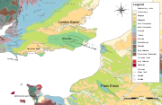
Hampshire Basin
Encyclopedia

Paleogene
The Paleogene is a geologic period and system that began 65.5 ± 0.3 and ended 23.03 ± 0.05 million years ago and comprises the first part of the Cenozoic Era...
age in southern England
Southern England
Southern England, the South and the South of England are imprecise terms used to refer to the southern counties of England bordering the English Midlands. It has a number of different interpretations of its geographic extents. The South is considered by many to be a cultural region with a distinct...
, underlying parts of Hampshire
Hampshire
Hampshire is a county on the southern coast of England in the United Kingdom. The county town of Hampshire is Winchester, a historic cathedral city that was once the capital of England. Hampshire is notable for housing the original birthplaces of the Royal Navy, British Army, and Royal Air Force...
, the Isle of Wight
Isle of Wight
The Isle of Wight is a county and the largest island of England, located in the English Channel, on average about 2–4 miles off the south coast of the county of Hampshire, separated from the mainland by a strait called the Solent...
, Dorset
Dorset
Dorset , is a county in South West England on the English Channel coast. The county town is Dorchester which is situated in the south. The Hampshire towns of Bournemouth and Christchurch joined the county with the reorganisation of local government in 1974...
, and Sussex
Sussex
Sussex , from the Old English Sūþsēaxe , is an historic county in South East England corresponding roughly in area to the ancient Kingdom of Sussex. It is bounded on the north by Surrey, east by Kent, south by the English Channel, and west by Hampshire, and is divided for local government into West...
. Like the London Basin
London Basin
The London Basin is an elongated, roughly triangular sedimentary basin approximately long which underlies London and a large area of south east England, south eastern East Anglia and the adjacent North Sea...
to the northeast, it is filled with sand
Sand
Sand is a naturally occurring granular material composed of finely divided rock and mineral particles.The composition of sand is highly variable, depending on the local rock sources and conditions, but the most common constituent of sand in inland continental settings and non-tropical coastal...
s and clay
Clay
Clay is a general term including many combinations of one or more clay minerals with traces of metal oxides and organic matter. Geologic clay deposits are mostly composed of phyllosilicate minerals containing variable amounts of water trapped in the mineral structure.- Formation :Clay minerals...
s of Paleocene
Paleocene
The Paleocene or Palaeocene, the "early recent", is a geologic epoch that lasted from about . It is the first epoch of the Palaeogene Period in the modern Cenozoic Era...
and younger age and it surrounded by a broken rim of chalk hill
Hill
A hill is a landform that extends above the surrounding terrain. Hills often have a distinct summit, although in areas with scarp/dip topography a hill may refer to a particular section of flat terrain without a massive summit A hill is a landform that extends above the surrounding terrain. Hills...
s of Cretaceous
Cretaceous
The Cretaceous , derived from the Latin "creta" , usually abbreviated K for its German translation Kreide , is a geologic period and system from circa to million years ago. In the geologic timescale, the Cretaceous follows the Jurassic period and is followed by the Paleogene period of the...
age.
Extent
The Hampshire Basin is the traditional name for the landward section of a basin underlying the northern English ChannelEnglish Channel
The English Channel , often referred to simply as the Channel, is an arm of the Atlantic Ocean that separates southern England from northern France, and joins the North Sea to the Atlantic. It is about long and varies in width from at its widest to in the Strait of Dover...
and much of central southern England, known more fully as the Hampshire-Dieppe
Dieppe, Seine-Maritime
Dieppe is a commune in the Seine-Maritime department in France. In 1999, the population of the whole Dieppe urban area was 81,419.A port on the English Channel, famous for its scallops, and with a regular ferry service from the Gare Maritime to Newhaven in England, Dieppe also has a popular pebbled...
Basin. It stretches a little over 100 miles (160 km) from the Dorchester area in the west to Beachy Head
Beachy Head
Beachy Head is a chalk headland on the south coast of England, close to the town of Eastbourne in the county of East Sussex, immediately east of the Seven Sisters. The cliff there is the highest chalk sea cliff in Britain, rising to 162 m above sea level. The peak allows views of the south...
in the east. Its southern boundary is marked by a monocline
Monocline
A monocline is a step-like fold in rock strata consisting of a zone of steeper dip within an otherwise horizontal or gently-dipping sequence.-Formation:Monoclines may be formed in several different ways...
, the Purbeck Monocline
Purbeck Monocline
The Purbeck Monocline is a geological fold. The term 'fold' is used in geology when one or more originally flat sedimentary strata surfaces are bent or curved as a result of plastic deformation. A monocline is a step-like fold, in which one limb is roughly horizontal...
, resulting in a near-vertical chalk ridge which forms the Purbeck Hills
Purbeck Hills
The Purbeck Hills and South Dorset Downs are a ridge of chalk downs in Dorset, England. The hills extend from the Dorset Downs west of Dorchester, where the River Frome begins to form a valley dividing them from the larger area of downland to the north. The ridge then runs east through the Isle...
of Dorset, running under the sea from Old Harry Rocks
Old Harry Rocks
The Old Harry Rocks are two chalk sea stacks located at Handfast Point, on the Isle of Purbeck in Dorset, southern England.- Location :Old Harry Rocks lie directly east of Studland, about 4 kilometres northeast of Swanage, and about 10 kilometres south of the large towns of Poole and...
to The Needles
The Needles
The Needles is a row of three distinctive stacks of chalk that rise out of the sea off the western extremity of the Isle of Wight, England, close to Alum Bay. The Needles lighthouse stands at the end of the formation...
and the central spine of the Isle of Wight and continuing under the English Channel as the Wight-Bray
Pays de Bray
The Pays de Bray is a small natural region of France situated to the north-east of Rouen, straddling the French départements of the Seine-Maritime and Oise...
monocline. The northern limit is the chalk of the South Downs
South Downs
The South Downs is a range of chalk hills that extends for about across the south-eastern coastal counties of England from the Itchen Valley of Hampshire in the west to Beachy Head, near Eastbourne, East Sussex, in the east. It is bounded on its northern side by a steep escarpment, from whose...
, Salisbury Plain
Salisbury Plain
Salisbury Plain is a chalk plateau in central southern England covering . It is part of the Southern England Chalk Formation and largely lies within the county of Wiltshire, with a little in Hampshire. The plain is famous for its rich archaeology, including Stonehenge, one of England's best known...
and Cranborne Chase
Cranborne Chase
Cranborne Chase is a Chalk plateau in central southern England, straddling the counties Dorset, Hampshire and Wiltshire. The plateau is part of the English Chalk Formation and is adjacent to Salisbury Plain and the West Wiltshire Downs in the north, the Dorset Downs to the south west and the...
. The basin at its widest is around 30 miles (48.3 km) from north to south between Salisbury
Salisbury
Salisbury is a cathedral city in Wiltshire, England and the only city in the county. It is the second largest settlement in the county...
and Newport
Newport, Isle of Wight
Newport is a civil parish and a county town of the Isle of Wight, an island off the south coast of England. Newport has a population of 23,957 according to the 2001 census...
.
Geography
The basin includes areas of forest and heath including Wareham ForestWareham Forest
Wareham Forest is a large coniferous plantation beside the A35 road near Wareham, between Poole and Dorchester, in Dorset, England. The forest is managed by the Forestry Commission for conservation and recreation....
, Arne
Arne, Dorset
Arne is a large village and civil parish in the Purbeck district of Dorset, England; situated east of Wareham. The local travel links are located from the village to Holton Heath railway station and to Bournemouth International Airport. The main road through the village is Arne Road connecting...
and the New Forest
New Forest
The New Forest is an area of southern England which includes the largest remaining tracts of unenclosed pasture land, heathland and forest in the heavily-populated south east of England. It covers south-west Hampshire and extends into south-east Wiltshire....
and the large south coast settlements of Bournemouth
Bournemouth
Bournemouth is a large coastal resort town in the ceremonial county of Dorset, England. According to the 2001 Census the town has a population of 163,444, making it the largest settlement in Dorset. It is also the largest settlement between Southampton and Plymouth...
, Southampton
Southampton
Southampton is the largest city in the county of Hampshire on the south coast of England, and is situated south-west of London and north-west of Portsmouth. Southampton is a major port and the closest city to the New Forest...
and Portsmouth
Portsmouth
Portsmouth is the second largest city in the ceremonial county of Hampshire on the south coast of England. Portsmouth is notable for being the United Kingdom's only island city; it is located mainly on Portsea Island...
. The coast has many drowned valleys (ria
Ria
A ria is a coastal inlet formed by the partial submergence of an unglaciated river valley. It is a drowned river valley that remains open to the sea. Typically, rias have a dendritic, treelike outline although they can be straight and without significant branches. This pattern is inherited from the...
s) including The Solent, Poole Harbour
Poole Harbour
Poole Harbour is a large natural harbour in Dorset, southern England, with the town of Poole on its shores. The harbour is a drowned valley formed at the end of the last ice age and is the estuary of several rivers, the largest being the Frome. The harbour has a long history of human settlement...
, Southampton Water
Southampton Water
Southampton Water is a tidal estuary north of the Solent and the Isle of Wight in England. The city of Southampton lies at its most northerly point. Along its salt marsh-fringed western shores lie the New Forest villages of Hythe and "the waterside", Dibden Bay, and the Esso oil refinery at Fawley...
, Portsmouth Harbour
Portsmouth Harbour
Portsmouth Harbour is a large natural harbour in Hampshire, England. Geographically it is a ria: formerly it was the valley of a stream flowing from Portsdown into the Solent River. The city of Portsmouth lies to the east on Portsea Island, and Gosport to the west on the mainland...
, Chichester Harbour
Chichester Harbour
Chichester Harbour is a large natural harbour to the south west of the city of Chichester on the Solent. It straddles the boundary of West Sussex and Hampshire. Geographically it is a ria. It is one of four natural harbours in that area of the coastline, the others being Portsmouth Harbour,...
, Langstone Harbour
Langstone Harbour
Langstone Harbour is an inlet of the English Channel in Hampshire, sandwiched between Portsea Island to the south and west, Hayling Island to the south and east, and Langstone to the north. Geographically it is a ria....
, Pagham Harbour
Pagham Harbour
Pagham Harbour is a natural harbour on England's south coast. It is south of the city of Chichester and near the towns of Pagham and Selsey.Geographically it is the smallest and most easterly of the harbours of the Solent....
, Yarmouth
Yarmouth, Isle of Wight
Yarmouth is a port and civil parish in the western part of the Isle of Wight, off the southern coast of mainland England. The town is named for its location at the mouth of the small Western Yar river...
, Cowes
Cowes
Cowes is an English seaport town and civil parish on the Isle of Wight. Cowes is located on the west bank of the estuary of the River Medina facing the smaller town of East Cowes on the east Bank...
and Bembridge
Bembridge
Bembridge is an affluent village and civil parish located on the easternmost point of the Isle of Wight. It had a population of 3,848 according to the 2001 census of the United Kingdom, leading to claims by residents that Bembridge is the largest village in England, and occasional claims that it is...
. In addition to the northern half of the Isle of Wight which lies within the basin, the harbours contain inhabited islands including Brownsea Island
Brownsea Island
Brownsea Island is the largest of the islands in Poole Harbour in the county of Dorset, England. The island is owned by the National Trust. Much of the island is open to the public and includes areas of woodland and heath with a wide variety of wildlife, together with cliff top views across Poole...
, Portsea Island
Portsea Island
Portsea Island is a small, flat and low lying island just off the south coast of England. The island is totally within, and contains a large proportion of, the city of Portsmouth. It has the third-largest population of any island in the British Isles, after the mainlands of Great Britain and...
, Hayling Island
Hayling Island
-Leisure activities:Although largely residential, Hayling is also a holiday, windsurfing and sailing centre, the site where windsurfing was invented....
and Thorney Island
Thorney Island (West Sussex)
Thorney Island is an island that juts into Chichester Harbour in West Sussex. It is separated from the mainland by a narrow channel called the Great Deep. The village of West Thorney lies on the east coast of the island and has been incorporated into the military base...
.
Drainage
The Hampshire Basin has no single dominant riverRiver
A river is a natural watercourse, usually freshwater, flowing towards an ocean, a lake, a sea, or another river. In a few cases, a river simply flows into the ground or dries up completely before reaching another body of water. Small rivers may also be called by several other names, including...
. In former times the Frome
River Frome, Dorset
The River Frome is a river in Dorset in the south of England. At 30 miles long it is the major chalkstream in southwest England. It is navigable upstream from Poole Harbour as far as the town of Wareham.-Geography:...
and Solent rivers would have drained much of the basin from west to east, fed by tributaries flowing from the north and south. At the end of the last ice age this system was disrupted by rising sea level
Sea level
Mean sea level is a measure of the average height of the ocean's surface ; used as a standard in reckoning land elevation...
s, which separated the Isle of Wight from the mainland
Mainland
Mainland is a name given to a large landmass in a region , or to the largest of a group of islands in an archipelago. Sometimes its residents are called "Mainlanders"...
. Today the western part of the basin drains via the rivers Frome and Piddle
River Piddle
The River Piddle or Trent or North River is a small rural Dorset river which rises next to Alton Pancras church and flows south and then south-easterly more or less parallel with its bigger neighbour, the River Frome, to Wareham, where they both enter Poole Harbour via...
into Poole Harbour, and via the Stour
River Stour, Dorset
The River Stour is a 60.5 mile long river which flows through Wiltshire and Dorset in southern England, and drains into the English Channel. It is sometimes called the Dorset Stour to distinguish it from rivers of the same name...
and Avon
River Avon, Hampshire
The River Avon is a river in the south of England. The river rises in the county of Wiltshire and flows through the city of Salisbury and the county of Hampshire before reaching the English Channel through Christchurch Harbour in the county of Dorset....
directly to the English Channel. The central part drains into the Solent (directly or via via Southampton Water), through the Lymington River
Lymington River
----The Lymington River is a small river in the south of england, flowing through the New Forest into the Solent at the town of Lymington. The river has a total length of 30 km, although above the point where it leaves the Crown lands of the New Forest at Brockenhurst it is known as the Highland...
, Test
River Test
The River Test is a river in Hampshire, England. The river has a total length of 40 miles and it flows through downland from its source near Ashe, 10 km to the west of Basingstoke , to the sea at the head of Southampton Water...
, Itchen
River Itchen, Hampshire
The River Itchen is a river in Hampshire, England. It flows from mid-Hampshire to join with Southampton Water below the Itchen Bridge in the city of Southampton. The river has a total length of , and is noted as one of England's - if not one of the World's - premier chalk streams for fly fishing,...
, Meon
River Meon
The River Meon is a river that flows through an area of Hampshire in southern England known as the Meon Valley, it flows generally southwards from the South Downs to the Solent. For most of its route it is a chalk stream, with a length of 21 miles .The River Meon rises approximately...
, Hamble
River Hamble
The River Hamble is a river in Hampshire, England. It rises near Bishop's Waltham and flows for some 7.5 miles through Botley, Bursledon and Swanwick before entering Southampton Water near Hamble-le-Rice and Warsash....
, Western Yar
Western Yar
The River Yar on the Isle of Wight, England, rises near the beach at Freshwater Bay, on the south coast of the island and flows only a few miles north to Yarmouth, on the north coast, where it meets the Solent. Most of the river is a tidal estuary...
, Medina
River Medina
The River Medina is the main river of the Isle of Wight, rising at St Catherine's Down in the south of the Island and through the capital Newport, towards the Solent at Cowes. The river is a navigable tidal estuary from Newport northwards where it takes the form of a ria . The Medina is 17km long...
and Eastern Yar
Eastern Yar
The River Yar on the Isle of Wight, England, rises in a chalk coomb in St. Catherine's Down near Niton, close to the southern point of the island...
. The eastern part of the basin is a narrow coastal plain
Coastal plain
A coastal plain is an area of flat, low-lying land adjacent to a seacoast and separated from the interior by other features. One of the world's longest coastal plains is located in eastern South America. The southwestern coastal plain of North America is notable for its species diversity...
draining into the many harbours via small stream
Stream
A stream is a body of water with a current, confined within a bed and stream banks. Depending on its locale or certain characteristics, a stream may be referred to as a branch, brook, beck, burn, creek, "crick", gill , kill, lick, rill, river, syke, bayou, rivulet, streamage, wash, run or...
s, and is crossed by larger rivers draining the Weald
Weald
The Weald is the name given to an area in South East England situated between the parallel chalk escarpments of the North and the South Downs. It should be regarded as three separate parts: the sandstone "High Weald" in the centre; the clay "Low Weald" periphery; and the Greensand Ridge which...
including the Arun
River Arun
The Arun is a river in the English county of West Sussex. Its source is a series of small streams in the St Leonard's Forest area, to the east of Horsham...
and Adur
River Adur
The Adur is a river in Sussex, England; it gives its name to the Adur district of West Sussex. The river was formerly navigable for large vessels up as far as Steyning, where there was a large port, but over time the river valley became silted up and the port moved down to the deeper waters nearer...
.
Geology
The main basin consists of an asymmetric synclineSyncline
In structural geology, a syncline is a fold, with younger layers closer to the center of the structure. A synclinorium is a large syncline with superimposed smaller folds. Synclines are typically a downward fold, termed a synformal syncline In structural geology, a syncline is a fold, with younger...
in the Cretaceous chalk, with a gentle dip
Strike and dip
Strike and dip refer to the orientation or attitude of a geologic feature. The strike line of a bed, fault, or other planar feature is a line representing the intersection of that feature with a horizontal plane. On a geologic map, this is represented with a short straight line segment oriented...
southwards from Salisbury Plain
Salisbury Plain
Salisbury Plain is a chalk plateau in central southern England covering . It is part of the Southern England Chalk Formation and largely lies within the county of Wiltshire, with a little in Hampshire. The plain is famous for its rich archaeology, including Stonehenge, one of England's best known...
terminating abruptly at a near vertical monocline in the south. The chalk surface dips from around 170 metres (560 ft) above sea level west of Winchester
Winchester
Winchester is a historic cathedral city and former capital city of England. It is the county town of Hampshire, in South East England. The city lies at the heart of the wider City of Winchester, a local government district, and is located at the western end of the South Downs, along the course of...
to 600 metres (1,968.5 ft) below sea level at Newport
Newport, Isle of Wight
Newport is a civil parish and a county town of the Isle of Wight, an island off the south coast of England. Newport has a population of 23,957 according to the 2001 census...
, before rising abruptly to around 200 metres (656.2 ft) above sea level in parts of the central hills of the Isle of Wight and the Purbeck Hills. The chalk can be visualised as a thin layer draped over rigid blocks of older rocks at depth, which have moved vertically due to the Alpine Orogeny
Alpine orogeny
The Alpine orogeny is an orogenic phase in the Late Mesozoic and Tertiary that formed the mountain ranges of the Alpide belt...
.
Beneath the chalk the geology is complex. It is believed that a series of major blocks separated by faults trending NW-SE is fragmented into smaller blocks by numerous east-west trending faults; one such block acts as a trap for the Wytch Farm
Wytch Farm
Wytch Farm is an oil field and processing facility in the Purbeck district of Dorset, England. It is the largest onshore oil field in western Europe. The facility, operated by BP, is hidden in a coniferous forest on Wytch Heath on the southern shore of Poole Harbour, two miles north of Corfe Castle...
oil field
Oil field
An oil field is a region with an abundance of oil wells extracting petroleum from below ground. Because the oil reservoirs typically extend over a large area, possibly several hundred kilometres across, full exploitation entails multiple wells scattered across the area...
. These blocks have moved vertically relative to each other during late Palaeozoic and Mesozoic
Mesozoic
The Mesozoic era is an interval of geological time from about 250 million years ago to about 65 million years ago. It is often referred to as the age of reptiles because reptiles, namely dinosaurs, were the dominant terrestrial and marine vertebrates of the time...
times, resulting in considerable variations in the thickness of the various formations deposited over them before the chalk. Rocks of Lower Greensand (Aptian
Aptian
The Aptian is an age in the geologic timescale or a stage in the stratigraphic column. It is a subdivision of the Early or Lower Cretaceous epoch or series and encompasses the time from 125.0 ± 1.0 Ma to 112.0 ± 1.0 Ma , approximately...
) age were deposited over an eroded surface, which ranges from Great Oolite
Great Oolite
The Great Oolite is a geological formation in Europe. It dates back to the Middle Jurassic.-Vertebrate fauna:This Limestone is dominant in many areas of the UK particularly in Birmingham and Anglesy. It is composed of oolites and lithic fragments...
(Early Jurassic
Jurassic
The Jurassic is a geologic period and system that extends from about Mya to Mya, that is, from the end of the Triassic to the beginning of the Cretaceous. The Jurassic constitutes the middle period of the Mesozoic era, also known as the age of reptiles. The start of the period is marked by...
Bathonian
Bathonian
In the geologic timescale the Bathonian is an age or stage of the Middle Jurassic. It lasted from approximately 167.7 Ma to around 164.7 Ma...
) to Weald Clay
Weald Clay
Weald Clay is a Lower Cretaceous sedimentary rock underlying areas of South East England. It is part of the Wealden Group of rocks. The clay is named after the Weald, an area of Sussex. It varies from orange and grey in colour and is used in brickmaking....
(mid-Cretaceous Hauterivian
Hauterivian
The Hauterivian is, in the geologic timescale, an age in the Early Cretaceous epoch or a stage in the Lower Cretaceous series. It spans the time between 136.4 ± 2 Ma and 130 ± 1.5 Ma...
) in age. The chalk itself varies considerably in thickness, with the results of a marine trangression
Transgression (geology)
A marine transgression is a geologic event during which sea level rises relative to the land and the shoreline moves toward higher ground, resulting in flooding. Transgressions can be caused either by the land sinking or the ocean basins filling with water...
progressing across into Dorset from the east. There is evidence that the top of the Upper Greensand to the west is the same age as the oldest chalk in the Isle of Wight.
Above the chalk the basin contains Palaeogene sediments ranging from Thanetian
Thanetian
The Thanetian is, in the ICS' Geologic timescale, the latest age or uppermost stratigraphic stage of the Paleocene Epoch or series. It spans the time between and . The Thanetian is preceded by the Selandian age and followed by the Ypresian age...
(Palaeocene) age to Rupelian
Rupelian
The Rupelian is, in the geologic timescale, the older of two ages or the lower of two stages of the Oligocene epoch/series. It spans the time between and . It is preceded by the Priabonian stage and is followed by the Chattian stage....
(Oligocene
Oligocene
The Oligocene is a geologic epoch of the Paleogene Period and extends from about 34 million to 23 million years before the present . As with other older geologic periods, the rock beds that define the period are well identified but the exact dates of the start and end of the period are slightly...
) age. The oldest beds, the Lambeth Group
Lambeth Group
The Lambeth Group is a stratigraphic group, a set of geological rock strata in the London and Hampshire Basins of southern England. It comprises a complex of vertically and laterally varying gravels, sands, silts and clays deposited between 56-55 million years before present during the Ypresian age...
('Reading
Reading, Berkshire
Reading is a large town and unitary authority area in England. It is located in the Thames Valley at the confluence of the River Thames and River Kennet, and on both the Great Western Main Line railway and the M4 motorway, some west of London....
Beds') and Thames Group ('London Clay
London Clay
The London Clay Formation is a marine geological formation of Ypresian age which crops out in the southeast of England. The London Clay is well known for the fossils it contains. The fossils from the Lower Eocene indicate a moderately warm climate, the flora being tropical or subtropical...
') outcrop in narrow bands towards the perimeter of the basin, from the coast at Studland
Studland
Studland is a small village on the Isle of Purbeck in the English county of Dorset. It is famous for its beaches and nature reserve. In 2001 Studland had a population of 480, the lowest in 50 years...
, around the perimeter of the Dorset heathlands, north and east past Romsey
Romsey
Romsey is a small market town in the county of Hampshire, England.It is 8 miles northwest of Southampton and 11 miles southwest of Winchester, neighbouring the village of North Baddesley...
, swinging southeast past Eastleigh
Eastleigh
Eastleigh is a railway town in Hampshire, England, and the main town in the Eastleigh borough which is part of Southampton Urban Area. The town lies between Southampton and Winchester, and is part of the South Hampshire conurbation...
and eastwards towards Chichester
Chichester
Chichester is a cathedral city in West Sussex, within the historic County of Sussex, South-East England. It has a long history as a settlement; its Roman past and its subsequent importance in Anglo-Saxon times are only its beginnings...
, Worthing
Worthing
Worthing is a large seaside town with borough status in West Sussex, within the historic County of Sussex, forming part of the Brighton/Worthing/Littlehampton conurbation. It is situated at the foot of the South Downs, west of Brighton, and east of the county town of Chichester...
and Shoreham-by-Sea
Shoreham-by-Sea
Shoreham-by-Sea is a small town, port and seaside resort in West Sussex, England. Shoreham-by-Sea railway station is located less than a mile from the town centre and London Gatwick Airport is away...
. Within this rim, over the greater part of the basin is an outcrop of younger Eocene
Eocene
The Eocene Epoch, lasting from about 56 to 34 million years ago , is a major division of the geologic timescale and the second epoch of the Paleogene Period in the Cenozoic Era. The Eocene spans the time from the end of the Palaeocene Epoch to the beginning of the Oligocene Epoch. The start of the...
deposits, the Bagshot
Bagshot Beds
In geology, the Bagshot Beds are a series of sands and clays of shallow-water origin, some being fresh-water, some marine. They belong to the upper Eocene formation of the London and Hampshire basins, in England and derive their name from Bagshot Heath in Surrey. They are also well developed in...
, Bracklesham
Bracklesham Beds
Bracklesham Beds, in geology, are a series of clays and marls, with sandy and lignitic beds, in the Middle Eocene of the Hampshire Basin, England....
and Barton
Barton Beds
Barton Beds is the name given to a series of grey and brown clays, with layers of sand, of Upper Eocene age , which are found in the Hampshire Basin of southern England. They are particularly well exposed in the cliffs at Barton-on-Sea, which is the world type locality for the Barton Beds, and...
beds. The youngest, Oligocene beds (Bouldnor Formation) only occur on the northern Isle of Wight; the Headon Hill beds of the New Forest
New Forest
The New Forest is an area of southern England which includes the largest remaining tracts of unenclosed pasture land, heathland and forest in the heavily-populated south east of England. It covers south-west Hampshire and extends into south-east Wiltshire....
, formerly classified as Oligocene, are now regarded as late Eocene
Eocene
The Eocene Epoch, lasting from about 56 to 34 million years ago , is a major division of the geologic timescale and the second epoch of the Paleogene Period in the Cenozoic Era. The Eocene spans the time from the end of the Palaeocene Epoch to the beginning of the Oligocene Epoch. The start of the...
.
The simple basin structure is complicated by localised folding. A smaller outcrop of Palaeocene and Eocene deposits occurs in a small syncline to the south-east of Salisbury
Salisbury
Salisbury is a cathedral city in Wiltshire, England and the only city in the county. It is the second largest settlement in the county...
. An anticline
Anticline
In structural geology, an anticline is a fold that is convex up and has its oldest beds at its core. The term is not to be confused with antiform, which is a purely descriptive term for any fold that is convex up. Therefore if age relationships In structural geology, an anticline is a fold that is...
to the north of Portsmouth
Portsmouth
Portsmouth is the second largest city in the ceremonial county of Hampshire on the south coast of England. Portsmouth is notable for being the United Kingdom's only island city; it is located mainly on Portsea Island...
results in the significant chalk ridge of Portsdown Hill
Portsdown Hill
Portsdown Hill is a long chalk hill in Hampshire, England, offering good views over Portsmouth, The Solent, Hayling Island and Gosport, with the Isle of Wight beyond. The hill is on the mainland, just to the north of Ports Creek, which separates the mainland from Portsea Island, on which lies the...
within the younger sediments; the London Clay to the north contains the Forest of Bere
Forest of Bere
The Forest of Bere lies north of Fareham. A mixture of woodland, open space, ponds, streams, heathland, farmland and downland it provides countryside access to the residents of South-East Hampshire having a number of paths and bridleways for walking and cycling...
. A similar structure further east causes chalk to outcrop between Bognor Regis
Bognor Regis
Bognor Regis is a seaside resort town and civil parish in the Arun district of West Sussex, on the south coast of England. It is south-south-west of London, west of Brighton, and south-east of the city of Chichester. Other nearby towns include Littlehampton east-north-east and Selsey to the...
and Worthing
Worthing
Worthing is a large seaside town with borough status in West Sussex, within the historic County of Sussex, forming part of the Brighton/Worthing/Littlehampton conurbation. It is situated at the foot of the South Downs, west of Brighton, and east of the county town of Chichester...
, separated from the chalk of the South Downs by a belt of Reading Beds and London Clay continuing from Havant
Havant
Havant is a town in south east Hampshire on the South coast of England, between Portsmouth and Chichester. It gives its name to the borough comprising the town and the surrounding area. The town has rapidly grown since the end of the Second World War.It has good railway connections to London,...
through Chichester
Chichester
Chichester is a cathedral city in West Sussex, within the historic County of Sussex, South-East England. It has a long history as a settlement; its Roman past and its subsequent importance in Anglo-Saxon times are only its beginnings...
and south of Arundel
Arundel
Arundel is a market town and civil parish in the South Downs of West Sussex in the south of England. It lies south southwest of London, west of Brighton, and east of the county town of Chichester. Other nearby towns include Worthing east southeast, Littlehampton to the south and Bognor Regis to...
to the coast at Lancing
Lancing, West Sussex
Lancing is a town and civil parish in the Adur district of West Sussex, England, on the western edge of the Adur Valley. It lies on the coastal plain between Sompting to the west, Shoreham-by-Sea to the east and the parish of Coombes to the north...
.
It is likely that the London and Hampshire basins were initially part of a single larger area of deposition
Deposition (geology)
Deposition is the geological process by which material is added to a landform or land mass. Fluids such as wind and water, as well as sediment flowing via gravity, transport previously eroded sediment, which, at the loss of enough kinetic energy in the fluid, is deposited, building up layers of...
covering the whole of southeast England during the Palaeocene. The two basins were progressively separated by the emergence of the Weald-Artois Anticline
Weald-Artois Anticline
The Weald–Artois anticline is a large anticline, a geological structure running between the regions of the Weald in southern England and the Artois in northeastern France. The fold formed during the Alpine orogeny, from the late Oligocene to middle Miocene as an uplifted form of the Weald basin...
during the Eocene. By the Oligocene the London Basin was wholly dry land, and only a small part of the Hampshire Basin, centred on the modern Solent, was an area of marine deposition.