
Haliacmon
Encyclopedia
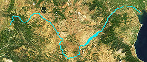
The Haliacmon is the longest river in Greece
, with a total length of 322 km (200.1 mi). Haliacmon is the traditional English name for the river, but many sources cite the formerly official Katharevousa
version of the name, Aliákmon. Today, the only official
variant is the demotic Aliákmonas.
It rises in the northern Pindus
mountains in northern Greece on the border with Albania
, before flowing southeast then northeast through the Greek peripheries
of West
and Central Macedonia
and then into Lake Kastoria, and into the dam and into the Thermaic Gulf
. It waters an extensive area, making it of great importance to agriculture in the region. The river forms the western portion of the delta of the Axiós
(aka Vardar
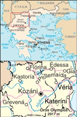
). The river runs in the prefectures of Kastoria
, Grevena
, Kozani
, Imathia
, and Pieria.
 The Haliacmon flows through Kastoria
, Neapoli, west of Siatista
and into the Grevena prefecture and east of Grevena, and to the south of Kozani and into the Polyfytos dam which is 20 km long and about 4 to 5 km wide, and southeast of Aiane, and into the gorges and southeast of Veria
and north of Aiginio
and northeast of Methone.
In antiquity, Claudius Ptolemy called the chain of mountains in which the river rises (northern Pindus
) the Canalovii. According to Julius Caesar
, the Haliacmon formed the line of demarcation between Macedon
and Thessaly
. In the upper part of its course it took a southeast direction through Elimiotis
, which it watered; and then, continuing to the northeast, formed the boundary between Pieria, Eordaea
, and Imathia
. In the time of Herodotus
the Haliacmon was apparently joined by the Loudias 7, 127, the discharge of the lake of Pella
; but a change has taken place in the course of the Loudias, which no longer joins the Haliacmon, but flows directly into the Aegean Sea
. The image below shows a wind gap
between the Haliacmon and Loudias watershed
s that is the probable ancient course of the Haliacmon.
It was the domain of the eponymous river god Haliacmon
.

Greece
Greece , officially the Hellenic Republic , and historically Hellas or the Republic of Greece in English, is a country in southeastern Europe....
, with a total length of 322 km (200.1 mi). Haliacmon is the traditional English name for the river, but many sources cite the formerly official Katharevousa
Katharevousa
Katharevousa , is a form of the Greek language conceived in the early 19th century as a compromise between Ancient Greek and the Modern Greek of the time, with a vocabulary largely based on ancient forms, but a much-simplified grammar. Originally, it was widely used both for literary and official...
version of the name, Aliákmon. Today, the only official
Official language
An official language is a language that is given a special legal status in a particular country, state, or other jurisdiction. Typically a nation's official language will be the one used in that nation's courts, parliament and administration. However, official status can also be used to give a...
variant is the demotic Aliákmonas.
It rises in the northern Pindus
Pindus
The Pindus mountain range is located in northern Greece and southern Albania. It is roughly 160 km long, with a maximum elevation of 2637 m . Because it runs along the border of Thessaly and Epirus, the Pindus range is often called the "spine of Greece"...
mountains in northern Greece on the border with Albania
Albania
Albania , officially known as the Republic of Albania , is a country in Southeastern Europe, in the Balkans region. It is bordered by Montenegro to the northwest, Kosovo to the northeast, the Republic of Macedonia to the east and Greece to the south and southeast. It has a coast on the Adriatic Sea...
, before flowing southeast then northeast through the Greek peripheries
Peripheries of Greece
The current official regional administrative divisions of Greece were instituted in 1987. Although best translated into English as "regions", the transcription peripheries is sometimes used, perhaps to distinguish them from the traditional regions which they replaced. The English word 'periphery'...
of West
West Macedonia
West Macedonia is one of the thirteen regions of Greece, consisting of the western part of Greek Macedonia. It is divided into the regional units of Florina, Grevena, Kastoria, and Kozani.-Geography:...
and Central Macedonia
Central Macedonia
Central Macedonia is one of the thirteen regions of Greece, consisting of the central part of the region of Macedonia. With a population of over 1.8 million, it is the second most populous in Greece after Attica.- Administration :...
and then into Lake Kastoria, and into the dam and into the Thermaic Gulf
Thermaic Gulf
The Thermaic Gulf is a gulf of the Aegean Sea located immediately south of Thessaloniki, east of Pieria and Imathia, and west of Chalkidiki . It was named after the ancient town of Therma, which was situated on the northeast coast of the gulf...
. It waters an extensive area, making it of great importance to agriculture in the region. The river forms the western portion of the delta of the Axiós
Axios
"Axios!" is an acclamation that is made by the faithful at the ordination of bishops, priests and deacons in the Orthodox and Eastern Catholic churches...
(aka Vardar
Vardar
The Vardar or Axios is the longest and major river in the Republic of Macedonia and also a major river of Greece. It is long, and drains an area of around . The maximum depth of river is ....
). The river runs in the prefectures of Kastoria
Kastoria Prefecture
Kastoria is one of the regional units of Greece. It is part of the region of West Macedonia. Its capital is the town of Kastoria.-Geography:...
, Grevena
Grevena Prefecture
Grevena is one of the regional units of Greece. It is part of the region of West Macedonia. Its capital is the town of Grevena.-Geography:Grevena borders the regional units of Ioannina to the west, Kastoria to the northwest, Kozani to the north and east, Larissa to the southeast and Trikala to...
, Kozani
Kozani Prefecture
Kozani is one of the regional units of Greece. It is part of the region of West Macedonia. Its capital is the city of Kozani.-Geography:Kozani borders the regional units of Kastoria to the west and northwest, Florina to the north, Pella to the northeast, Imathia and Pieria to the east, Larissa ...
, Imathia
Imathia Prefecture
Imathia is one of the regional units of Greece. It is part of the region of Central Macedonia. The capital of Imathia is the city of Veroia.-Administration:The regional unit Imathia is subdivided into 3 municipalities...
, and Pieria.
Kastoria
Kastoria is a city in northern Greece in the periphery of West Macedonia. It is the capital of Kastoria peripheral unit. It is situated on a promontory on the western shore of Lake Orestiada, in a valley surrounded by limestone mountains...
, Neapoli, west of Siatista
Siatista
Siatista is a town and a former municipality in Kozani peripheral unit, West Macedonia, Greece. Since the 2011 local government reform it is part of the municipality Voio, of which it is the seat and a municipal unit. It lies 28 km southwest of the city Kozani. It was built on the austral...
and into the Grevena prefecture and east of Grevena, and to the south of Kozani and into the Polyfytos dam which is 20 km long and about 4 to 5 km wide, and southeast of Aiane, and into the gorges and southeast of Veria
Veria
Veria is a city built at the foot of Vermion Mountains in Greece. It is a commercial center of Macedonia, the capital of the prefecture of Imathia, the province of Imathia and the seat of a bishop of the Greek Orthodox Church...
and north of Aiginio
Aiginio
Aiginio is a town and a former municipality in Pieria regional unit, Greece. Since the 2011 local government reform it is part of the municipality Pydna-Kolindros, of which it is the seat and a municipal unit. Population 5,264 .-External links:**...
and northeast of Methone.
In antiquity, Claudius Ptolemy called the chain of mountains in which the river rises (northern Pindus
Pindus
The Pindus mountain range is located in northern Greece and southern Albania. It is roughly 160 km long, with a maximum elevation of 2637 m . Because it runs along the border of Thessaly and Epirus, the Pindus range is often called the "spine of Greece"...
) the Canalovii. According to Julius Caesar
Julius Caesar
Gaius Julius Caesar was a Roman general and statesman and a distinguished writer of Latin prose. He played a critical role in the gradual transformation of the Roman Republic into the Roman Empire....
, the Haliacmon formed the line of demarcation between Macedon
Macedon
Macedonia or Macedon was an ancient kingdom, centered in the northeastern part of the Greek peninsula, bordered by Epirus to the west, Paeonia to the north, the region of Thrace to the east and Thessaly to the south....
and Thessaly
Thessaly
Thessaly is a traditional geographical region and an administrative region of Greece, comprising most of the ancient region of the same name. Before the Greek Dark Ages, Thessaly was known as Aeolia, and appears thus in Homer's Odyssey....
. In the upper part of its course it took a southeast direction through Elimiotis
Elimiotis
Elimiotis or Elimeia or Elimaea was a region of Upper Macedonia that was located along the Haliacmon, north of Perrhaebia/Thessaly, west of Pieria, east of Parauaea, and south of Orestis. In earlier times, it was independent, but later was incorporated into the Argead kingdom of Macedon...
, which it watered; and then, continuing to the northeast, formed the boundary between Pieria, Eordaea
Eordaea
This article is based on the article Eordea Province on the English Wikipedia, accessed on 13 September 2011.Eordeae was an ancient kingdom and later administrative unit of Ancient Macedonia...
, and Imathia
Imathia Prefecture
Imathia is one of the regional units of Greece. It is part of the region of Central Macedonia. The capital of Imathia is the city of Veroia.-Administration:The regional unit Imathia is subdivided into 3 municipalities...
. In the time of Herodotus
Herodotus
Herodotus was an ancient Greek historian who was born in Halicarnassus, Caria and lived in the 5th century BC . He has been called the "Father of History", and was the first historian known to collect his materials systematically, test their accuracy to a certain extent and arrange them in a...
the Haliacmon was apparently joined by the Loudias 7, 127, the discharge of the lake of Pella
Pella
Pella , an ancient Greek city located in Pella Prefecture of Macedonia in Greece, was the capital of the ancient kingdom of Macedonia.-Etymology:...
; but a change has taken place in the course of the Loudias, which no longer joins the Haliacmon, but flows directly into the Aegean Sea
Aegean Sea
The Aegean Sea[p] is an elongated embayment of the Mediterranean Sea located between the southern Balkan and Anatolian peninsulas, i.e., between the mainlands of Greece and Turkey. In the north, it is connected to the Marmara Sea and Black Sea by the Dardanelles and Bosporus...
. The image below shows a wind gap
Wind gap
A wind gap is a valley through which a waterway once flowed, but is now dry as a result of stream capture. A water gap is a similar feature, but one in which a waterway still flows...
between the Haliacmon and Loudias watershed
Drainage basin
A drainage basin is an extent or an area of land where surface water from rain and melting snow or ice converges to a single point, usually the exit of the basin, where the waters join another waterbody, such as a river, lake, reservoir, estuary, wetland, sea, or ocean...
s that is the probable ancient course of the Haliacmon.
It was the domain of the eponymous river god Haliacmon
Haliacmon (mythology)
Haliacmon was in Greek mythology a son of Oceanus and Thetys. He was a minor river god in his own right, of the eponymous Haliacmon in Macedonia. In other mythological traditions he was the son of Palaestinus and grandson of Poseidon....
.