

Hai River
Encyclopedia

-
- This article is about the river in China. For the canal in Iraq see Shatt al-HayyShatt al-HayyThe Gharraf Canal, Shaṭṭ al-Ḥayy , also known as Shaṭṭ al-Gharrāf or the Hai river, is an ancient canal that connects Tigris with Euphrates in Iraq. As an Ottoman defensive line lay along the canal, it was a theater to intense military action during First World War; e.g. the siege of Kut...
- This article is about the river in China. For the canal in Iraq see Shatt al-Hayy
The Hai River , previously called Bai He (Chinese: 白河; pinyin: Bái Hé; literally "White River"; Pei Ho in Western sources), is a river in the People's Republic of China which flows through Beijing
Beijing
Beijing , also known as Peking , is the capital of the People's Republic of China and one of the most populous cities in the world, with a population of 19,612,368 as of 2010. The city is the country's political, cultural, and educational center, and home to the headquarters for most of China's...
and Tianjin
Tianjin
' is a metropolis in northern China and one of the five national central cities of the People's Republic of China. It is governed as a direct-controlled municipality, one of four such designations, and is, thus, under direct administration of the central government...
before emptying into the Yellow Sea
Yellow Sea
The Yellow Sea is the name given to the northern part of the East China Sea, which is a marginal sea of the Pacific Ocean. It is located between mainland China and the Korean Peninsula. Its name comes from the sand particles from Gobi Desert sand storms that turn the surface of the water golden...
at the Bohai Gulf.
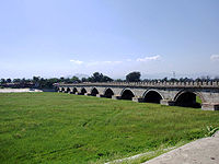
The Hai River at Tianjin
Tianjin
' is a metropolis in northern China and one of the five national central cities of the People's Republic of China. It is governed as a direct-controlled municipality, one of four such designations, and is, thus, under direct administration of the central government...
is formed by the confluence
Confluence
Confluence, in geography, describes the meeting of two or more bodies of water.Confluence may also refer to:* Confluence , a property of term rewriting systems...
of five rivers, the Southern Canal, Ziya River, Daqing River, Yongding River, and the Northern Canal. The southern and northern canals are parts of the Grand Canal
Grand Canal of China
The Grand Canal in China, also known as the Beijing-Hangzhou Grand Canal is the longest canal or artificial river in the world. Starting at Beijing, it passes through Tianjin and the provinces of Hebei, Shandong, Jiangsu and Zhejiang to the city of Hangzhou...
. The Southern Canal is joined by the Wei River at Linqing
Linqing
Linqing is a county-level city within the prefecture-level city of Liaocheng in western Shandong Province, China. It is located north-northwest of the prefectural capital Liaocheng. The city proper has about residents , whereas Linqing County as a whole had inhabitants in 1999. The city is...
. The Northern Canal joins with the Bai He (or Chaobai River) at Tongzhou
Tongzhou District
Tongzhou District is a district of Beijing, the capital of People's Republic of China. It is located in southeast Beijing and considered the eastern gateway to the Chinese capital...
. The Northern Canal (sharing a channel with Bai He) is also the only waterway from the sea to Beijing
Beijing
Beijing , also known as Peking , is the capital of the People's Republic of China and one of the most populous cities in the world, with a population of 19,612,368 as of 2010. The city is the country's political, cultural, and educational center, and home to the headquarters for most of China's...
. Therefore, early Westerners also called the Hai He the Bai He.
At Tianjin, through the Grand Canal, the Hai connects with the Yellow
Yellow River
The Yellow River or Huang He, formerly known as the Hwang Ho, is the second-longest river in China and the sixth-longest in the world at the estimated length of . Originating in the Bayan Har Mountains in Qinghai Province in western China, it flows through nine provinces of China and empties into...
and Yangtze
Yangtze River
The Yangtze, Yangzi or Cháng Jiāng is the longest river in Asia, and the third-longest in the world. It flows for from the glaciers on the Tibetan Plateau in Qinghai eastward across southwest, central and eastern China before emptying into the East China Sea at Shanghai. It is also one of the...
rivers. The construction of the Grand Canal greatly altered the rivers of the Hai He basin. Previously, the Wei, Ziya Yongding
Yongding River
The Yongding River is a river in northern China. It is one of the main tributaries in the Hai River system and is best known as the largest river to flow through Beijing Municipality.-Geography:...
and Bai Rivers flowed separately to the sea. The Grand Canal cut through the lower reaches of these rivers and fused them into one outlet to the sea, in the form of the current Hai He.
Hai He is 1329 kilometres (825.8 mi) long measured from the longest tributary. However, the Hai He is only around 70 kilometres (43.5 mi) from Tianjin to its estuary. Its basin has an area of approximately 319000 square kilometres (123,166.6 sq mi). Its annual flow is only half that of the Yellow River, or one-thirtieth that of the Yangtze River.
History
During the Boxer RebellionBoxer Rebellion
The Boxer Rebellion, also called the Boxer Uprising by some historians or the Righteous Harmony Society Movement in northern China, was a proto-nationalist movement by the "Righteous Harmony Society" , or "Righteous Fists of Harmony" or "Society of Righteous and Harmonious Fists" , in China between...
, Imperial Chinese forces deployed a weapon called "electric mine
Naval mine
A naval mine is a self-contained explosive device placed in water to destroy surface ships or submarines. Unlike depth charges, mines are deposited and left to wait until they are triggered by the approach of, or contact with, an enemy vessel...
s" on June 15, at the Peiho river before the Battle of Dagu Forts (1900), to prevent the western Eight-Nation Alliance
Eight-Nation Alliance
The Eight-Nation Alliance was an alliance of Austria-Hungary, France, Germany, Italy, Japan, Russia, the United Kingdom, and the United States whose military forces intervened in China to suppress the anti-foreign Boxers and relieve the siege of the diplomatic legations in Beijing .- Events :The...
from sending ships to attack. This was reported by American military intelligence in the United States. War Dept. by the United States. Adjutant-General's Office. Military Information Division.
Like the Yellow River, the Hai is exceedingly muddy because of the powdery soil through which it flows. The silt carried by the water deposits in the lower reaches, sometimes causing flooding. The waters from the five major tributaries only have one shallow outlet to the sea, which makes such floods stronger. Because China's capital (and second largest city), Beijing, and the third largest city, Tianjin, both lie in the Hai He Basin, Hai He floods cause a significant loss. To alleviate flooding, reservoirs have been built and artificial channels dug to divert excess water directly into the sea. For example, the Chaobai river is diverted to the Chaobai Xin river and no longer joins with the Northern Canal.
Due to industrial and urban development in the Hai He Basin, the volume of water flow has greatly decreased. Many smaller tributaries and some of the major tributaries are dry for most of the year. With reduced water flow, water pollution worsens. The water shortage in the Hai He basin is expected to be alleviated by the South-North Water Transfer Project
South-North Water Transfer Project
The South-North Water Transfer Project is a multi-decade infrastructure project of the People's Republic of China to better utilize water resources available to China. This is to be achieved through the South North Water Diversion Project...
.
Further reading
- Domagalski, J.L., et al. (2001). Comparative water-quality assessment of the Hai He River basin in the People's Republic of China and three similar basins in the United States [U.S. Geological Survey Professional Paper 1647]. Reston, VA: U.S. Department of the Interior, U.S. Geological Survey.