
Görmeli
Encyclopedia
Taurus Mountains
Taurus Mountains are a mountain complex in southern Turkey, dividing the Mediterranean coastal region of southern Turkey from the central Anatolian Plateau. The system extends along a curve from Lake Eğirdir in the west to the upper reaches of the Euphrates and Tigris rivers in the east...
near Ermenek
Ermenek
Ermenek is a town and district of Karaman Province in the Central Anatolia region of Turkey. According to 2000 census, population of the district is 42,643 of which 15,509 live in the town of Ermenek.-Name:...
, Karaman province
Karaman Province
Karaman Province is a province of central Turkey. It has an area of 9,163 km². It has a population of 232,633 . According to the 2000 census the population was 243,210. Population density is 27.54 people/km². The traffic code is 70. The capital is the city of Karaman...
, Turkey
Turkey
Turkey , known officially as the Republic of Turkey , is a Eurasian country located in Western Asia and in East Thrace in Southeastern Europe...
.
Geography
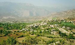
Görmeli is located in the Karaman Region’s Taurus Mountains range, on the slopes of Taurus mountainsTaurus Mountains
Taurus Mountains are a mountain complex in southern Turkey, dividing the Mediterranean coastal region of southern Turkey from the central Anatolian Plateau. The system extends along a curve from Lake Eğirdir in the west to the upper reaches of the Euphrates and Tigris rivers in the east...
. It is on the south-east side of Ermenek
Ermenek
Ermenek is a town and district of Karaman Province in the Central Anatolia region of Turkey. According to 2000 census, population of the district is 42,643 of which 15,509 live in the town of Ermenek.-Name:...
town, in the Karaman province
Karaman Province
Karaman Province is a province of central Turkey. It has an area of 9,163 km². It has a population of 232,633 . According to the 2000 census the population was 243,210. Population density is 27.54 people/km². The traffic code is 70. The capital is the city of Karaman...
. It is 18 km. from the center of Ermenek and 90 km. from the touristic towns of the mediterranean region Anamur
Anamur
Anamur is a town and district of the province of Mersin, on the Mediterranean coast of southern Turkey, between Antalya and the city of Mersin.Anamur is Turkey's southernmost point, a coastal resort famous for its bananas and peanuts.-Etymology:...
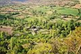
. The Map coordinates are 40° 42° North parallels and 30° 10° East meridians. The village is on the main road of Ermenek and Gülnar. It is surrounded by forests and high mountains. The area is very productive, due to watery fields and soft soil. Almost all vegetables and fruits are grown locally. Görmeli presents quite a spectacular sight with its meadows, streams, plants, trees, animals, and the traditional lifestyle of its people.
History
The time in which the area first became inhabited is still unknown. However, it is said that people were brought from Adana by the Emirate of Karamanid hundreds of years ago. Ala Köprü is also called Görmel. Köprüsü is a bridge 5 km (3 mi) away from the village. It was built by the Karamanid Emirate. It is a masterpiece that could have reached this time. Its length is 27m. and its width is 4.70 m. Sadly, the future of this historical bridge is in jeopardy as it is going to be submerged by the Ermenek DamErmenek Dam
The Ermenek Dam is an arch dam on the Göksu River in Karaman Province, Turkey. The development was backed by the Turkish State Hydraulic Works. Completed in 2009, the primary purpose of the tall dam is to support its 300 MW power station.-References:...
, currently under construction.
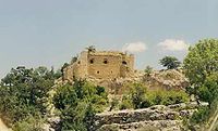
There is a historical building called Mennan Castle in the Nısa Neighbourhood near Görmeli. Mennan means "place to shelter in". The castle was built with rocks on a perpendicular mountain. It is also known as the castle that Karamanid from the Ottoman Gedik Ahmet Pasha, as a result of which Pir Ahmet Bey committed suicide within it. Sadly The castle is in ruins, dilapidated by treasure hunters. Some blame the authorities, whom, they say, did not attach enough importance to this historical building to protect it, with the result that the construction has been suffering from years of neglect.
Culture
Economy
Neighbourhoods
Görmeli village is divided into six neighbourhoods (capital one in bold):- Boyalık
- Tekke
- Kışla
- Tuztaşı
- Köyyakası
- Nısa