

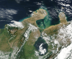
Gulf of Venezuela
Encyclopedia

Headlands and bays
Headlands and bays are two related features of the coastal environment.- Geology and geography :Headlands and bays are often found on the same coastline. A bay is surrounded by land on three sides, whereas a headland is surrounded by water on three sides. Headlands are characterized by high,...
of the Caribbean Sea
Caribbean Sea
The Caribbean Sea is a sea of the Atlantic Ocean located in the tropics of the Western hemisphere. It is bounded by Mexico and Central America to the west and southwest, to the north by the Greater Antilles, and to the east by the Lesser Antilles....
bounded by the Venezuela
Venezuela
Venezuela , officially called the Bolivarian Republic of Venezuela , is a tropical country on the northern coast of South America. It borders Colombia to the west, Guyana to the east, and Brazil to the south...
n states of Zulia and Falcón and by Guajira Department, Colombia
Colombia
Colombia, officially the Republic of Colombia , is a unitary constitutional republic comprising thirty-two departments. The country is located in northwestern South America, bordered to the east by Venezuela and Brazil; to the south by Ecuador and Peru; to the north by the Caribbean Sea; to the...
. A 54 km (34 mi) strait
Strait
A strait or straits is a narrow, typically navigable channel of water that connects two larger, navigable bodies of water. It most commonly refers to a channel of water that lies between two land masses, but it may also refer to a navigable channel through a body of water that is otherwise not...
connects it with Maracaibo Lake to the south.
Location
The Gulf is located in the north of South AmericaSouth America
South America is a continent situated in the Western Hemisphere, mostly in the Southern Hemisphere, with a relatively small portion in the Northern Hemisphere. The continent is also considered a subcontinent of the Americas. It is bordered on the west by the Pacific Ocean and on the north and east...
, between Paraguaná Peninsula
Paraguaná Peninsula
The Paraguaná Peninsula is a peninsula in Venezuela, situated in the north of Falcón State. The island of Aruba lies 27 km to the north. Bonaire and Curaçao are slightly further away. The Paraguaná Peninsula is connected to the rest of the state by a natural isthmus of Médanos. The Peninsula...
of the Falcón State in Venezuela and Guajira Peninsula
Guajira Peninsula
Guajira Peninsula , is a peninsula in northern Colombia and northwestern Venezuela in the Caribbean Sea...
in Colombia
Colombia
Colombia, officially the Republic of Colombia , is a unitary constitutional republic comprising thirty-two departments. The country is located in northwestern South America, bordered to the east by Venezuela and Brazil; to the south by Ecuador and Peru; to the north by the Caribbean Sea; to the...
and is connected to Maracaibo Lake through an artificial navigation canal
Canal
Canals are man-made channels for water. There are two types of canal:#Waterways: navigable transportation canals used for carrying ships and boats shipping goods and conveying people, further subdivided into two kinds:...
. There is currently a dispute between Colombia and Venezuela over the gulf that has not been resolved, despite the decades-long negotiations conducted by a bilateral commission.
History
It was discovered by westerners in 1499 when an expedition commanded by Alonso de OjedaAlonso de Ojeda
Alonso de Ojeda was a Spanish navigator, governor and conquistador. His name is sometimes spelled Alonzo and Oxeda.-Early life:...
in which he was accompanied by Amerigo Vespucci
Amerigo Vespucci
Amerigo Vespucci was an Italian explorer, financier, navigator and cartographer. The Americas are generally believed to have derived their name from the feminized Latin version of his first name.-Expeditions:...
, explored the Venezuelan coasts compiling information and naming the new lands, said expedition arrived to the gulf after passing through the Netherlands Antilles
Netherlands Antilles
The Netherlands Antilles , also referred to informally as the Dutch Antilles, was an autonomous Caribbean country within the Kingdom of the Netherlands, consisting of two groups of islands in the Lesser Antilles: Aruba, Bonaire and Curaçao , in Leeward Antilles just off the Venezuelan coast; and Sint...
and the Peninsula of Paraguaná.
Territorial waters are also in dispute over the gulf. The border dispute surged after the independence of Colombia and Venezuela from Spain in the 19th Century. The Spanish empire
Spanish Empire
The Spanish Empire comprised territories and colonies administered directly by Spain in Europe, in America, Africa, Asia and Oceania. It originated during the Age of Exploration and was therefore one of the first global empires. At the time of Habsburgs, Spain reached the peak of its world power....
did not delimit the area because the Wayuu
Wayuu
Wayuu is an Amerindian ethnic group of the La Guajira Peninsula in northern Colombia and northwest Venezuela. They are part of the Maipurean language family.- Geography :...
indigenous group posed resistance in the area. The land boundary was finally settled in 1941, but not the maritime.
Economic importance
The main factor that gives importance to these waters is the fact that it connects the Caribbean SeaCaribbean Sea
The Caribbean Sea is a sea of the Atlantic Ocean located in the tropics of the Western hemisphere. It is bounded by Mexico and Central America to the west and southwest, to the north by the Greater Antilles, and to the east by the Lesser Antilles....
and Lake Maracaibo
Lake Maracaibo
Lake Maracaibo is a large brackish bay in Venezuela at . It is connected to the Gulf of Venezuela by Tablazo Strait at the northern end, and fed by numerous rivers, the largest being the Catatumbo. It is commonly considered a lake rather than a bay or lagoon, and at 13,210 km² it would be the...
, an important source of crude petroleum for Venezuela. The gulf therefore helps connect the wells and refineries in Lake Maracaibo to the world markets.