

Gulf of Corinth
Encyclopedia
Ionian Sea
The Ionian Sea , is an arm of the Mediterranean Sea, south of the Adriatic Sea. It is bounded by southern Italy including Calabria, Sicily and the Salento peninsula to the west, southern Albania to the north, and a large number of Greek islands, including Corfu, Zante, Kephalonia, Ithaka, and...
separating the Peloponnese
Peloponnese
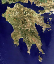
The Peloponnese, Peloponnesos or Peloponnesus , is a large peninsula , located in a region of southern Greece, forming the part of the country south of the Gulf of Corinth...
from western mainland Greece
Greece
Greece , officially the Hellenic Republic , and historically Hellas or the Republic of Greece in English, is a country in southeastern Europe....
. It is bounded in the east by the Isthmus of Corinth
Isthmus of Corinth
The Isthmus of Corinth is the narrow land bridge which connects the Peloponnese peninsula with the rest of the mainland of Greece, near the city of Corinth. The word "isthmus" comes from the Ancient Greek word for "neck" and refers to the narrowness of the land. The Isthmus was known in the ancient...
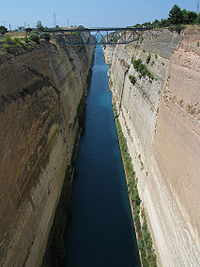
which includes the shipping route of the Corinth Canal
Corinth Canal
The Corinth Canal is a canal that connects the Gulf of Corinth with the Saronic Gulf in the Aegean Sea. It cuts through the narrow Isthmus of Corinth and separates the Peloponnesian peninsula from the Greek mainland, thus effectively making the former an island. The builders dug the canal through...
, and in the west by the Strait of Rion, which separates the Gulf of Corinth from the outer Gulf of Patras
Gulf of Patras
The Gulf of Patras is a branch of the Ionian Sea. On the east, it is closed by the Strait of Rion between capes Rio, Greece and Antirrio, near the Rio-Antirio bridge. On the west, it is bounded by a line from Oxeia island to Cape Araxos...
at Cape Drepano
Drepano, Achaea
Drepano, is a village in the municipality of Patras, Achaea, Greece. As of 2001, it had a population of 388 for the village and sits at 1,000 m above sea level...
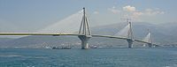
, where the narrowest point is crossed by the Rio-Antirio bridge
Rio-Antirio bridge
The Rion-Antirion bridge , officially the Charilaos Trikoupis bridge after the statesman who first envisaged it, is the world's longest multi-span cable-stayed bridge...
. The Gulf of Corinth is almost surrounded by the prefectures of Aetolia-Acarnania
Aetolia-Acarnania
Aetolia-Acarnania is one of the regional units of Greece. It is part of the region of West Greece. It is located in the western part of Greece; the regional unit is a combination of the geographic regions Aetolia and Acarnania. Its capital is Missolonghi for historical reasons, with its biggest...
, Phocis
Phocis
Phocis is one of the regional units of Greece. It is part of the administrative region of Central Greece. It stretches from the western mountainsides of Parnassus on the east to the mountain range of Vardousia on the west, upon the Gulf of Corinth...
in the north, Boeotia
Boeotia
Boeotia, also spelled Beotia and Bœotia , is one of the regional units of Greece. It is part of the region of Central Greece. It was also a region of ancient Greece. Its capital is Livadeia, the second largest city being Thebes.-Geography:...
in the northeast, Attica
Attica
Attica is a historical region of Greece, containing Athens, the current capital of Greece. The historical region is centered on the Attic peninsula, which projects into the Aegean Sea...
in the east, Corinthia
Corinthia
Corinthia is one of the regional units of Greece. It is part of the region of Peloponnese. It is situated around the city of Corinth, in the north-eastern part of the Peloponnese peninsula.-Geography:...
in the southeast and south and Achaea
Achaea
Achaea is one of the regional units of Greece. It is part of the region of West Greece. It is situated in the northwestern part of the Peloponnese peninsula. The capital is Patras. The population exceeds 300,000 since 2001.-Geography:...
in the southwest. The gulf is one of the most seismically active regions in Europe.
In medieval times
Ottoman Greece
Most of Greece gradually became part of the Ottoman Empire from the 15th century until its declaration of independence in 1821, a historical period also known as Tourkokratia ....
, the gulf was known as the Gulf of Lepanto. Here the third Battle of Lepanto
Battle of Lepanto (1571)
The Battle of Lepanto took place on 7 October 1571 when a fleet of the Holy League, a coalition of Catholic maritime states, decisively defeated the main fleet of the Ottoman Empire in five hours of fighting on the northern edge of the Gulf of Patras, off western Greece...
was fought in 1571, destroying the Ottoman
Ottoman Empire
The Ottoman EmpireIt was usually referred to as the "Ottoman Empire", the "Turkish Empire", the "Ottoman Caliphate" or more commonly "Turkey" by its contemporaries...
fleet. In 1772 another Turkish fleet was destroyed by the Russians at the entrance to the gulf. The town of Lepanto is now named Naupactus
Naupactus
Naupactus or Nafpaktos , is a town and a former municipality in Aetolia-Acarnania, West Greece, Greece. Since the 2011 local government reform it is part of the municipality Nafpaktia, of which it is the seat and a municipal unit...
.
The shipping routes between Athens
Athens
Athens , is the capital and largest city of Greece. Athens dominates the Attica region and is one of the world's oldest cities, as its recorded history spans around 3,400 years. Classical Athens was a powerful city-state...
and to the ports of the rest of the world including the Mediterranean
Mediterranean Sea
The Mediterranean Sea is a sea connected to the Atlantic Ocean surrounded by the Mediterranean region and almost completely enclosed by land: on the north by Anatolia and Europe, on the south by North Africa, and on the east by the Levant...
ports pass along this gulf. Ferry routes link Aigio and Agios Nikolaos in the western part of the gulf.
- Length: 130 km
- Width: 8.4 to 32 km
- Max Depth 935 m
Geology of the gulf
The Gulf is being created by the expansion of a tectonic rift due to the westward movement of the Anatolian Plate, and expands by 10 mm per year. The surrounding faultsGeologic fault
In geology, a fault is a planar fracture or discontinuity in a volume of rock, across which there has been significant displacement along the fractures as a result of earth movement. Large faults within the Earth's crust result from the action of tectonic forces...
can produce earthquakes up to magnitude 6.8, though they are relatively uncommon.
Cities and towns
The cities and towns that lie next to the gulf are:- Nafpaktos (northwest)
- Sergoula BeachSergoula BeachSergoula Beach is a beach and a settlement near the city of Nafpaktos and Efpalio in Greece. It is situated in a mountainous and hilly coast...
, no port, beach - Glyfada, no port
- Spilia, no port
- Agios Nikolaos (north)
- GalaxidiGalaxidiGalaxidi , is a town and a former municipality in the southern part of Phocis, Greece. Since the 2011 local government reform it is part of the municipality Delphi, of which it is a municipal unit. It has a small harbor on the Gulf of Corinth. The Greek National Road 48/E65 connects Galaxidi with...
(north), small port - Itea (north), small port
- KirraKirra, PhocisKirra , is a village in Phocis, central Greece. It is part of the municipal unit of Itea. It is also sometimes called Adrastea. Kirra is part of a Trifecta starting in the north with Delphi, descending south to the Gulf of Corinth to Itea, which is the main city on the water in that area, and then...
(north), no port - Agios Vasileios, small port
- Porto Germeno (Aigosthena)Porto Germeno (Aigosthena)Porto Germeno is a resort area located on the west side of Attica prefecture on the northeast coast of the Corinthian Gulf...
, east, small port, beaches - Psatha, east, huge beach
- Alepochori, (southeast)
- LoutrakiLoutrakiLoutraki is a seaside resort located 84 km W of Athens and 4 km NE of Corinth in the Prefecture of Corinthia, Greece. Loutraki is the seat of the municipality Loutraki-Perachora. The town is well-known for its vast natural springs and its therapeutic spas.-History:In antiquity a town...
, no port - CorinthCorinthCorinth is a city and former municipality in Corinthia, Peloponnese, Greece. Since the 2011 local government reform it is part of the municipality Corinth, of which it is the seat and a municipal unit...
(southeast) - KiatoKiatoKiato is a coastal town in Greece that is agricultural-based. The town is located in the northern part of the prefecture of Corinthia in the Peloponnese, Greece. Kiato is located in a sandy area which features lemon trees, orange trees, and other fruit-bearing trees. It has a lot of tourist...
, (southeast) - XylokastroXylokastroXylokastro is a town and a former municipality in Corinthia, Peloponnese, Greece. Since the 2011 local government reform it is part of the municipality Xylokastro-Evrostina, of which it is a municipal unit. It is 40 km W of Corinth via Greek National Road 8A/E65...
(south) - DerveniDerveni, CorinthiaDerveni is a coastal town in prefecture of Corinthia in the Peloponnesus, Greece. It is the seat of the municipality Evrostini. It is linked by the old, mostly coastal, national road and a new, thought secondary, highway to mainland Greece and the Western Peloponnese.Its population stands at 1514...
- Krathio (southwest), no port
- DiakoptoDiakoptoDiakopto is a town and a former municipality in Achaea, West Greece, Greece. Since the 2011 local government reform it is part of the municipality Aigialeia, of which it is a municipal unit. Population app. 7,005 . The town of Diakopto is situated on the Gulf of Corinth, and at the lower end of...
(southwest), beach town - AigioAigioAigio is a town and a former municipality in Achaea, West Greece, Greece. Since the 2011 local government reform it is part of the municipality Aigialeia, of which it is the seat and a municipal unit. Its population is around 30,000. Aigio is surrounded by trees in the north and cliffs in the...
(southwest) - PatrasPatrasPatras , ) is Greece's third largest urban area and the regional capital of West Greece, located in northern Peloponnese, 215 kilometers west of Athens...
(southeast), major port - LongosLongos, GreeceLongos is a village located in the municipal unit of Sympoliteia in the northeastern part of Achaea in the Peloponnese, Greece. The village is connected with the old national road GR-8 and through the interchange of Selianitika/Longos with the New National Road...
(southwest) - Selianitika (southwest)
- Akoli Beach (southwest)
- Kato Rodina (west southwest)
- PsathopyrgosPsathopyrgosPsathopyrgos is a tourist village located in the municipal unit of Rio in the northern part of Achaea. It is the northernmost community in the Peloponnese. Psathopyrgos is located southeast of Cape Drepano, a trapezoidal cape facing the northwest and is the northernmost point in the Peloponnese...
(west)
Southern ebbing
- VolinaiosVolinaiosVolinaios or Volineos , also Drepaneiko is a river in the western part of the Achaia prefecture. It empties into the Gulf of Corinth...
River - Selemnos River
- Creek E of ArachovitikaArachovitikaArachovitika is a village located in the municipal unit of Rio in the northern part of Achaea, Greece. Cape Drepano is a trapezoidal cape facing the northwest and is the northernmost point in the Peloponnese and the prefecture of Achaia. The village is connected slightly northwest of the old GR-8...
and Drepano - SelinountaSelinountaSelinounta or Selinous is a Greek village located about 35 km south of Aigio, west of Corinth and about 185 km west Athens, north-northwest of Kalavryta and about 60 km east of Patras. Selinus is named after the nearby river. The GR-9 Selinounta or Selinous is a Greek village...
River - Vouraikos River
- River east of DiakoptoDiakoptoDiakopto is a town and a former municipality in Achaea, West Greece, Greece. Since the 2011 local government reform it is part of the municipality Aigialeia, of which it is a municipal unit. Population app. 7,005 . The town of Diakopto is situated on the Gulf of Corinth, and at the lower end of...
- Stygas River
- Zacholitikos River
- Asopus River (Corinthia)
- Sythas River - XylokastroXylokastroXylokastro is a town and a former municipality in Corinthia, Peloponnese, Greece. Since the 2011 local government reform it is part of the municipality Xylokastro-Evrostina, of which it is a municipal unit. It is 40 km W of Corinth via Greek National Road 8A/E65...