

Guiana
Encyclopedia
The Guiana Shield is one of the three craton
Craton
A craton is an old and stable part of the continental lithosphere. Having often survived cycles of merging and rifting of continents, cratons are generally found in the interiors of tectonic plates. They are characteristically composed of ancient crystalline basement rock, which may be covered by...
s of the South American Plate
South American Plate
The South American Plate is a continental tectonic plate which includes the continent of South America and also a sizeable region of the Atlantic Ocean seabed extending eastward to the Mid-Atlantic Ridge....
. It is a 1.7 billion year old Precambrian
Precambrian
The Precambrian is the name which describes the large span of time in Earth's history before the current Phanerozoic Eon, and is a Supereon divided into several eons of the geologic time scale...
geological formation in northeast South America
South America
South America is a continent situated in the Western Hemisphere, mostly in the Southern Hemisphere, with a relatively small portion in the Northern Hemisphere. The continent is also considered a subcontinent of the Americas. It is bordered on the west by the Pacific Ocean and on the north and east...
that forms a portion of the northern coast. The higher elevations on the shield
Shield (geology)
A shield is generally a large area of exposed Precambrian crystalline igneous and high-grade metamorphic rocks that form tectonically stable areas. In all cases, the age of these rocks is greater than 570 million years and sometimes dates back 2 to 3.5 billion years...
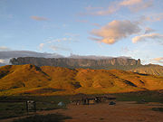
are called the Guiana Highlands, which is where the impressive and mysterious table-like mountains called tepui
Tepui
A tepui , or tepuy, is a table-top mountain or mesa found in the Guiana Highlands of South America, especially in Venezuela. The word tepui means "house of the gods" in the native tongue of the Pemon, the indigenous people who inhabit the Gran Sabana....
s are found. The Guiana Highlands are also the source of some of the world's most spectacular waterfalls such as Angel Falls, Kaieteur Falls
Kaieteur Falls
Kaieteur Falls is a high-volume waterfall on the Potaro River in central Guyana, Potaro-Siparuni region. It is located inKaieteur National Park. It is 226 meters high when measured from its plunge over a sandstone and conglomerate cliff to the first break...
and Kuquenan Falls.
The Guiana Shield underlies Guyana
Guyana
Guyana , officially the Co-operative Republic of Guyana, previously the colony of British Guiana, is a sovereign state on the northern coast of South America that is culturally part of the Anglophone Caribbean. Guyana was a former colony of the Dutch and of the British...
(previously British Guiana), Suriname
Suriname
Suriname , officially the Republic of Suriname , is a country in northern South America. It borders French Guiana to the east, Guyana to the west, Brazil to the south, and on the north by the Atlantic Ocean. Suriname was a former colony of the British and of the Dutch, and was previously known as...
(previously Dutch Guiana) and French Guiana
French Guiana
French Guiana is an overseas region of France, consisting of a single overseas department located on the northern Atlantic coast of South America. It has borders with two nations, Brazil to the east and south, and Suriname to the west...
(or Guyane), as well as parts of Colombia
Colombia
Colombia, officially the Republic of Colombia , is a unitary constitutional republic comprising thirty-two departments. The country is located in northwestern South America, bordered to the east by Venezuela and Brazil; to the south by Ecuador and Peru; to the north by the Caribbean Sea; to the...
, Venezuela
Venezuela
Venezuela , officially called the Bolivarian Republic of Venezuela , is a tropical country on the northern coast of South America. It borders Colombia to the west, Guyana to the east, and Brazil to the south...
and Brazil
Brazil
Brazil , officially the Federative Republic of Brazil , is the largest country in South America. It is the world's fifth largest country, both by geographical area and by population with over 192 million people...
. The rocks of the Guiana Shield consist of metasediments and metavolcanics (greenstones
Greenschist
Greenschist is a general field petrologic term applied to metamorphic or altered mafic volcanic rock. The term greenstone is sometimes used to refer to greenschist but can refer to other rock types too. The green is due to abundant green chlorite, actinolite and epidote minerals that dominate the...
) overlain by quasi-horizontal layers of sandstones, quartzites, shales
Shalës
Shalës is a municipality in the Elbasan District, Elbasan County, central Albania. The municipality consists of the villages Shalës, Licaj, Kurtalli, Xibrake, Xherie and Kodras....
and conglomerates
Conglomerate (geology)
A conglomerate is a rock consisting of individual clasts within a finer-grained matrix that have become cemented together. Conglomerates are sedimentary rocks consisting of rounded fragments and are thus differentiated from breccias, which consist of angular clasts...
intruded by sills of younger mafic intrusives such as gabbros.
Geomorphology
There are three upland areas of the Guiana Shield:- The Guiana Highlands proper are in Venezuela east of the Orinoco and extend across much of west-central Guyana and into the northern RoraimaRoraimaRoraima is the northernmost and least populated state of Brazil, located in the Amazon region. It borders the states of Amazonas and Pará, as well as the nations of Venezuela and Guyana. The population is 400,000 and the capital is Boa Vista...
state in Brazil. - The Tumucumaque Uplands which are a series of central massifs in an arc from the Wilhelmina MountainsWilhelmina MountainsThe Wilhelmina Mountains are a mountain range in central Suriname that extends about from west to east. Its highest peak is Julianatop with 1280 m . Another high peak is the Tafelberg. It is named after the Queen Wilhelmina...
of south-central Suriname, along the southern boundary of Suriname and Guyana, forming the Acarai Mountains of Roraima state and the Tumuc-Humac Mountains of ParáParáPará is a state in the north of Brazil. It borders the Brazilian states of Amapá, Maranhão, Tocantins, Mato Grosso, Amazonas and Roraima. To the northwest it also borders Guyana and Suriname, and to the northeast it borders the Atlantic Ocean. The capital is Belém.Pará is the most populous state...
and AmapáAmapáAmapá is one of the states of Brazil, located in the extreme north, bordering French Guiana and Suriname to the north. To the east is the Atlantic Ocean, and to the south and west is the Brazilian state of Pará. Perhaps one of the main features of the state is the River Oiapoque, as it was once...
states of Brazil. From this arc, the southern uplands slope gently downwards towards the Amazon River and the northern uplands slope gently downwards toward the Atlantic. - The Chiribiquete Plateau is a sandstone topped plateauPlateauIn geology and earth science, a plateau , also called a high plain or tableland, is an area of highland, usually consisting of relatively flat terrain. A highly eroded plateau is called a dissected plateau...
with an elevation of 900 m (2,953 ft) that forms the western edge of the shield. The plateau is separated from the eastern AndesAndesThe Andes is the world's longest continental mountain range. It is a continual range of highlands along the western coast of South America. This range is about long, about to wide , and of an average height of about .Along its length, the Andes is split into several ranges, which are separated...
by the thick NeogeneNeogeneThe Neogene is a geologic period and system in the International Commission on Stratigraphy Geologic Timescale starting 23.03 ± 0.05 million years ago and ending 2.588 million years ago...
sediments of the Sub-Andean Trough that runs along the northern and western rim of the Guiana Shield.
The north-central part of the Guiana Highlands is dominated by high flat-topped peaks called tepui
Tepui
A tepui , or tepuy, is a table-top mountain or mesa found in the Guiana Highlands of South America, especially in Venezuela. The word tepui means "house of the gods" in the native tongue of the Pemon, the indigenous people who inhabit the Gran Sabana....
s, of the Roraima supergroup and Quasi-Roraima formation, and the rounded granite peaks of the Parguaza and Imataca complexes to the north and southwestern edges of the area. The highest tepui is Monte Roraima
Monte Roraima
Mount Roraima is the highest of the Pakaraima chain of tepui plateau in South America. First described by the English explorer Sir Walter Raleigh in 1596, its summit area is defended by 400-metre-tall cliffs on all sides...
at 2,810 m (9,219 ft), on whose top plateau the Venezuela, Guyana and Brazil border tripoint is located, but the Guiana Shield's highest point is Pico da Neblina
Pico da Neblina
Pico da Neblina is the highest mountain in Brazil, above sea level, in the Serra do Imeri, a section of the Guiana Highlands on the Brazil–Venezuela border. As determined by a border survey expedition in 1962, its summit lies just within Brazilian territory, at a horizontal distance of only from...
in Brazil (next to the Venezuelan border) at 2,994 m (9,822 ft). Pico da Neblina is not a tepui but a rather sharp peak, and is located far to the west and south of the area where tepuis are found.
Ecology

Biodiversity
Biodiversity is the degree of variation of life forms within a given ecosystem, biome, or an entire planet. Biodiversity is a measure of the health of ecosystems. Biodiversity is in part a function of climate. In terrestrial habitats, tropical regions are typically rich whereas polar regions...
in the world. The Shield has over 2200 vertebrate
Vertebrate
Vertebrates are animals that are members of the subphylum Vertebrata . Vertebrates are the largest group of chordates, with currently about 58,000 species described. Vertebrates include the jawless fishes, bony fishes, sharks and rays, amphibians, reptiles, mammals, and birds...
species and 1680 bird
Bird
Birds are feathered, winged, bipedal, endothermic , egg-laying, vertebrate animals. Around 10,000 living species and 188 families makes them the most speciose class of tetrapod vertebrates. They inhabit ecosystems across the globe, from the Arctic to the Antarctic. Extant birds range in size from...
species. The Shield is overlain by the largest expanse of undisturbed tropical rain forest in the world. Guianan rain forest is similar in nature to Amazonian rain forest and known Protected Areas include the Iwokrama Forest of central Guyana and the Kanuku National Park of southern Guyana. In Venezuela the forests are protected by the Canaima
Canaima National Park
Canaima National Park is a 30,000 km² park in south-eastern Venezuela that borders Brazil and Guyana. It is located in Bolívar State, and roughly occupies the same area as the Gran Sabana region....
, Kaieteur
Kaieteur National Park
Kaieteur National Park is a National Park located in the Potaro-Siparuni Region of Guyana. The Park's boundaries and purpose are defined in the Kaieteur National Park Act, and was created to preserve the natural scenery , and its fauna and flora...
, Parima-Tapirapeco
Parima Tapirapecó National Park
Parima Tapirapecó National Park is a Venezuelan national park in the southern state of Amazonas. Established in June 1991, it has an area of 38,290 km² , and is the largest national park in Venezuela. In it are protected the headwaters of the Orinoco, likewise the natural space and culture of...
and Neblina
Pico da Neblina National Park
Pico da Neblina National Park is a national park in the north of Brazil, bordering on Venezuela. The latter country also has an adjoining national park, called Neblina as well. The Brazilian national park was created in 1979, and it is one of the country's largest national parks, with...
National Parks.
See also
- TepuiTepuiA tepui , or tepuy, is a table-top mountain or mesa found in the Guiana Highlands of South America, especially in Venezuela. The word tepui means "house of the gods" in the native tongue of the Pemon, the indigenous people who inhabit the Gran Sabana....
- Canadian ShieldCanadian ShieldThe Canadian Shield, also called the Laurentian Plateau, or Bouclier Canadien , is a vast geological shield covered by a thin layer of soil that forms the nucleus of the North American or Laurentia craton. It is an area mostly composed of igneous rock which relates to its long volcanic history...
- Caribbean South AmericaCaribbean South AmericaCaribbean South America is a region of South America consisting of the nations that border the Caribbean Sea, namely:*Colombia*Venezuela...
- Monte RoraimaMonte RoraimaMount Roraima is the highest of the Pakaraima chain of tepui plateau in South America. First described by the English explorer Sir Walter Raleigh in 1596, its summit area is defended by 400-metre-tall cliffs on all sides...
- Pico da NeblinaPico da NeblinaPico da Neblina is the highest mountain in Brazil, above sea level, in the Serra do Imeri, a section of the Guiana Highlands on the Brazil–Venezuela border. As determined by a border survey expedition in 1962, its summit lies just within Brazilian territory, at a horizontal distance of only from...
- Great American InterchangeGreat American InterchangeThe Great American Interchange was an important paleozoogeographic event in which land and freshwater fauna migrated from North America via Central America to South America and vice versa, as the volcanic Isthmus of Panama rose up from the sea floor and bridged the formerly separated continents...
- Geography of South AmericaGeography of South AmericaThe geography of South America contains many diverse regions and climates. Geographically, South America is generally considered a continent forming the southern portion of the American landmass, south and east of the Panama-Colombia border by most authorities, or south and east of the Panama Canal...