

Guayas River
Encyclopedia
River
A river is a natural watercourse, usually freshwater, flowing towards an ocean, a lake, a sea, or another river. In a few cases, a river simply flows into the ground or dries up completely before reaching another body of water. Small rivers may also be called by several other names, including...
in western Ecuador
Ecuador
Ecuador , officially the Republic of Ecuador is a representative democratic republic in South America, bordered by Colombia on the north, Peru on the east and south, and by the Pacific Ocean to the west. It is one of only two countries in South America, along with Chile, that do not have a border...
. It gives name to the Guayas Province
Guayas Province
Guayas is a coastal province in Ecuador. It is bordered to the west by Manabí, Santa Elena, and the Pacific Ocean ; to the east by Los Ríos, Bolívar, Chimborazo, Cañar, and Azuay; to the north by Los Ríos and Bolívar; and to the south by El Oro and the Pacific Ocean.With a population of over 3...
, and it is the most important river in South America
South America
South America is a continent situated in the Western Hemisphere, mostly in the Southern Hemisphere, with a relatively small portion in the Northern Hemisphere. The continent is also considered a subcontinent of the Americas. It is bordered on the west by the Pacific Ocean and on the north and east...
that does not flow into the Atlantic Ocean
Atlantic Ocean
The Atlantic Ocean is the second-largest of the world's oceanic divisions. With a total area of about , it covers approximately 20% of the Earth's surface and about 26% of its water surface area...
or any of its sea
Sea
A sea generally refers to a large body of salt water, but the term is used in other contexts as well. Most commonly, it means a large expanse of saline water connected with an ocean, and is commonly used as a synonym for ocean...
s. Its total length, including the Daule River
Daule River
The Daule River is a river in Ecuador, in Guayas Province. At Guayaquil, it joins the Babahoyo River; from that point the confluence becomes the Guayas River.-Cities along the River:*Pichincha, Ecuador*Balzar*Colimes*Palestina*Santa Lucía*Daule...
, is 389 km.
Course
The Guayas River has one of its sourceSource (river or stream)
The source or headwaters of a river or stream is the place from which the water in the river or stream originates.-Definition:There is no universally agreed upon definition for determining a stream's source...
s in the Andes
Andes
The Andes is the world's longest continental mountain range. It is a continual range of highlands along the western coast of South America. This range is about long, about to wide , and of an average height of about .Along its length, the Andes is split into several ranges, which are separated...
and the Chimborazo (volcano)
Chimborazo (volcano)
Chimborazo is a currently inactive stratovolcano located in the Cordillera Occidental range of the Andes. Its last known eruption is believed to have occurred around 550 AD....
, Ecuador's highest volcano. The coat of arms
Coat of arms
A coat of arms is a unique heraldic design on a shield or escutcheon or on a surcoat or tabard used to cover and protect armour and to identify the wearer. Thus the term is often stated as "coat-armour", because it was anciently displayed on the front of a coat of cloth...
of Ecuador shows an image of the river descending from the mountain
Mountain
Image:Himalaya_annotated.jpg|thumb|right|The Himalayan mountain range with Mount Everestrect 58 14 160 49 Chomo Lonzorect 200 28 335 52 Makalurect 378 24 566 45 Mount Everestrect 188 581 920 656 Tibetan Plateaurect 250 406 340 427 Rong River...
. Guayas is the name of the lower part of the river, which starts at the confluence
Confluence (geography)
In geography, a confluence is the meeting of two or more bodies of water. It usually refers to the point where two streams flow together, merging into a single stream...
of the Daule River
Daule River
The Daule River is a river in Ecuador, in Guayas Province. At Guayaquil, it joins the Babahoyo River; from that point the confluence becomes the Guayas River.-Cities along the River:*Pichincha, Ecuador*Balzar*Colimes*Palestina*Santa Lucía*Daule...
from the west and the Babahoyo River
Babahoyo River
The Babahoyo River is a river in western Ecuador, fed by tributaries rising in the Andes Mountains. It takes its name from the town of Babahoyo in Los Ríos. At Durán, it joins the Daule River to form the Guayas River, which continues to the Pacific Ocean....
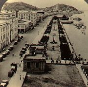
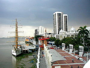
from the east, between the cities of Guayaquil
Guayaquil
Guayaquil , officially Santiago de Guayaquil , is the largest and the most populous city in Ecuador,with about 2.3 million inhabitants in the city and nearly 3.1 million in the metropolitan area, as well as that nation's main port...
and Durán
Durán, Ecuador
Durán, also known as Eloy Alfaro, is a city located in the province of Guayas, Ecuador, near the junction between the Daule & Babahoyo rivers, and where the Guayas River forms. This town is the capital of the Durán canton, which was created in 1986 by a local government decree...
, in Guayas province
Guayas Province
Guayas is a coastal province in Ecuador. It is bordered to the west by Manabí, Santa Elena, and the Pacific Ocean ; to the east by Los Ríos, Bolívar, Chimborazo, Cañar, and Azuay; to the north by Los Ríos and Bolívar; and to the south by El Oro and the Pacific Ocean.With a population of over 3...
. The Guayas River then flows around Santay Island
Santay Island
Santay Islandis a 2200 ha. island located in Guayas, Ecuador. It is part of the Durán Canton. It is surrounded by the Guayas River and populated by 47 families living there since the 50's and before. Santay has been declared the 1041 Ramsar site and the island is in the process of becoming a...
, and becomes one current again. From the confluence to the delta
River delta
A delta is a landform that is formed at the mouth of a river where that river flows into an ocean, sea, estuary, lake, reservoir, flat arid area, or another river. Deltas are formed from the deposition of the sediment carried by the river as the flow leaves the mouth of the river...
60 kilometers away, it borders Guayaquil (canton)
Guayaquil (canton)
The Guayaquil Canton, official the Municipality of Guayaquil, is a canton in the center of the Guayas Province in western Ecuador. The canton was named after its seat, the city of Guayaquil, the most populous city in Ecuador.-Political divisions:...
and Durán cantons, and Guayaquil
Guayaquil
Guayaquil , officially Santiago de Guayaquil , is the largest and the most populous city in Ecuador,with about 2.3 million inhabitants in the city and nearly 3.1 million in the metropolitan area, as well as that nation's main port...
and Naranjal cantons, just before the delta.
Delta
The Guayas River forms a very complex deltaRiver delta
A delta is a landform that is formed at the mouth of a river where that river flows into an ocean, sea, estuary, lake, reservoir, flat arid area, or another river. Deltas are formed from the deposition of the sediment carried by the river as the flow leaves the mouth of the river...
. Its most important feature is the existence of a slough
River delta
A delta is a landform that is formed at the mouth of a river where that river flows into an ocean, sea, estuary, lake, reservoir, flat arid area, or another river. Deltas are formed from the deposition of the sediment carried by the river as the flow leaves the mouth of the river...
called Estero Salado, surrounded by swamps and affected by tides. The area between the Guayas River and the Estero Salado forms a maze
Maze
A maze is a tour puzzle in the form of a complex branching passage through which the solver must find a route. In everyday speech, both maze and labyrinth denote a complex and confusing series of pathways, but technically the maze is distinguished from the labyrinth, as the labyrinth has a single...
of islands, some of which have been transformed into slum
Slum
A slum, as defined by United Nations agency UN-HABITAT, is a run-down area of a city characterized by substandard housing and squalor and lacking in tenure security. According to the United Nations, the percentage of urban dwellers living in slums decreased from 47 percent to 37 percent in the...
s. The Cobina Slough connects the Estero Salado with the river.
The main course of the river is affected by tides, and forms a small group of islands; the most important of them is Mondragón. The river then meets the Gulf of Guayaquil
Gulf of Guayaquil
The Gulf of Guayaquil is a large body of water of the Pacific Ocean in western South America. Its northern limit is the city of Salinas, in Ecuador, and its southern limit is Punta Pariñas, in Peru.The gulf takes its name from the city of Guayaquil...
, an inlet of the Pacific Ocean
Pacific Ocean
The Pacific Ocean is the largest of the Earth's oceanic divisions. It extends from the Arctic in the north to the Southern Ocean in the south, bounded by Asia and Australia in the west, and the Americas in the east.At 165.2 million square kilometres in area, this largest division of the World...
. Its influence is noticeable in the Puná Island
Puná Island
Puná Island is an Island off the coast of southern Ecuador at approximately 80 degrees west longitude and 3 degrees south latitude. It is located at the head of the Gulf of Guayaquil, south of the mouth of the Guayas River and the city of Guayaquil, Ecuador's largest city and chief port...
, and in the Jambelí Strait, in the province of El Oro
El Oro Province
El Oro province is the southernmost of Ecuador's coastal provinces. It was named for its historically important gold production. Today it is one of the world's major exporters of bananas. The capital is Machala.-Geography:To the north and east the province has borders with the provinces Guayas,...
.
By: Franklin Lliguicota ( Eduardo 11)
Watershed
Drainage basin
A drainage basin is an extent or an area of land where surface water from rain and melting snow or ice converges to a single point, usually the exit of the basin, where the waters join another waterbody, such as a river, lake, reservoir, estuary, wetland, sea, or ocean...
in South America
South America
South America is a continent situated in the Western Hemisphere, mostly in the Southern Hemisphere, with a relatively small portion in the Northern Hemisphere. The continent is also considered a subcontinent of the Americas. It is bordered on the west by the Pacific Ocean and on the north and east...
west of the Andes
Andes
The Andes is the world's longest continental mountain range. It is a continual range of highlands along the western coast of South America. This range is about long, about to wide , and of an average height of about .Along its length, the Andes is split into several ranges, which are separated...
mountains. It has an area 34,500 km², in nine provinces: Los Ríos
Los Ríos Province
Los Ríos is a province in Ecuador. The capital is Babahoyo. The province was founded on September 30, 1948 under legistative decree. Its capital Babahoyo was founded October, 6, 1860...
, Guayas
Guayas Province
Guayas is a coastal province in Ecuador. It is bordered to the west by Manabí, Santa Elena, and the Pacific Ocean ; to the east by Los Ríos, Bolívar, Chimborazo, Cañar, and Azuay; to the north by Los Ríos and Bolívar; and to the south by El Oro and the Pacific Ocean.With a population of over 3...
, Bolívar, Manabí
Manabí Province
Manabí is a province in Ecuador. Its capital is Portoviejo. The province is named after the Manabí people.-Economy:Manabí's economy is based heavily on natural resources such as cacao, bananas, cotton, etc. It's industrial sector is based on Tuna canning, tobacco, and alcoholic beverage production...
, Cañar
Cañar Province
Cañar is a province in Ecuador. The capital is Azogues. At the time of census 2005 the province had a population of 221,045. It contains the 16th-century ruins of Ingapirca, the best-known Inca settlement in Ecuador and a product of their conquest of the indigenous Cañari.- Cantons :The province...
, Pichincha
Pichincha Province
Pichincha is a province of Ecuador located in the northern sierra region; its capital and largest city is Quito. It is bordered by Imbabura & Esmeraldas to the north, Cotopaxi & Santo Domingo de los Tsáchilas to the south, Napo & Sucumbíos to the east, and Esmeraldas & Santo Domingo de los...
, Azuay
Azuay Province
Azuay is a province of Ecuador, created 25 June 1824. It encompasses an area of . Its capital is Cuenca. It is located in the south center of Ecuador in the highlands. Its mountains reach above sea level in the national park of El Cajas....
, Chimborazo
Chimborazo Province
Chimborazo is a province in Ecuador, located in the central Ecuadorian Andes, containing a section of Sangay National Park. The capital is Riobamba. The province contains Chimborazo , Ecuador's highest mountain.- Cantons :...
and Cotopaxi
Cotopaxi Province
Cotopaxi is one of the provinces of Ecuador. The capital is Latacunga. The province contains the Cotopaxi Volcano, an intermittent volcano with a height of 19,388 feet.- Cantons :The province is divided into 7 cantons...
. The river discharges into the Gulf of Guayaquil
Gulf of Guayaquil
The Gulf of Guayaquil is a large body of water of the Pacific Ocean in western South America. Its northern limit is the city of Salinas, in Ecuador, and its southern limit is Punta Pariñas, in Peru.The gulf takes its name from the city of Guayaquil...
30 millions of cubic meters of water
Water
Water is a chemical substance with the chemical formula H2O. A water molecule contains one oxygen and two hydrogen atoms connected by covalent bonds. Water is a liquid at ambient conditions, but it often co-exists on Earth with its solid state, ice, and gaseous state . Water also exists in a...
every year.
Cities along the Daule River
- PichinchaPichincha, EcuadorPichincha is a city in Pichincha Canton in the Manabí Province in Ecuador.It is situated along the Daule River....
- BalzarBalzarBalzar is a city located in northern Guayas Province, Ecuador, on the Daule River, near Los Ríos Province. It is the seat of Balzar Canton, and the agricultural center in northern Guayas....
- ColimesColimesColimes is a town located in northern Guayas, Ecuador, on the Daule River. It is the seat of Colimes Canton.As of the census of 2001, there are 21,049 people residing within canton limits. Its most important crops are: rice, cocoa, and coffee....
- Palestina
- Santa Lucía
- Daule
- NobolNobolNobol is a town located in central Guayas, Ecuador. It is the seat of Nobol Canton, created in 1992.As of the census of 2001, there are 14,753 people residing within the canton limits. The town is situated about 38.5 kilometres north of Guayaquil...
- GuayaquilGuayaquilGuayaquil , officially Santiago de Guayaquil , is the largest and the most populous city in Ecuador,with about 2.3 million inhabitants in the city and nearly 3.1 million in the metropolitan area, as well as that nation's main port...
Cities along the Guayas River
- GuayaquilGuayaquilGuayaquil , officially Santiago de Guayaquil , is the largest and the most populous city in Ecuador,with about 2.3 million inhabitants in the city and nearly 3.1 million in the metropolitan area, as well as that nation's main port...
- DuránDurán, EcuadorDurán, also known as Eloy Alfaro, is a city located in the province of Guayas, Ecuador, near the junction between the Daule & Babahoyo rivers, and where the Guayas River forms. This town is the capital of the Durán canton, which was created in 1986 by a local government decree...
2.195239°S 79.870074°W