

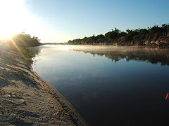
Gualeguay River
Encyclopedia
Mesopotamia, Argentina
La Mesopotamia, Región Mesopotámica is the humid and verdant area of north-east Argentina, comprising the provinces of Misiones, Entre Ríos and Corrientes. The region called Litoral consists of the Mesopotamia and the provinces of Chaco, Formosa and Santa Fe...
province
Provinces of Argentina
Argentina is subdivided into twenty-three provinces and one autonomous city...
of Entre Ríos
Entre Ríos Province
Entre Ríos is a northeastern province of Argentina, located in the Mesopotamia region. It borders the provinces of Buenos Aires , Corrientes and Santa Fe , and Uruguay in the east....
, Argentina
Argentina
Argentina , officially the Argentine Republic , is the second largest country in South America by land area, after Brazil. It is constituted as a federation of 23 provinces and an autonomous city, Buenos Aires...
. It is born in the north of the province, in the region between the cities of Federación
Federación, Entre Ríos
Federación is a city in the northeast of the province of Entre Ríos, Argentina. It has 13,789 inhabitants as per the . It lies on the provincial and international border with Uruguay, by the reservoir of the Salto Grande Dam, on the right-hand banks of the Uruguay River, about 45 km upstream from...
and San José de Feliciano
San José de Feliciano
San José de Feliciano is a city in the north of the province of Entre Ríos, Argentina, near the border with Corrientes. It has 11,137 inhabitants as per the , and is the head town of the Feliciano Department.The city was officially founded on 1818...
, and meander
Meander
A meander in general is a bend in a sinuous watercourse. A meander is formed when the moving water in a stream erodes the outer banks and widens its valley. A stream of any volume may assume a meandering course, alternately eroding sediments from the outside of a bend and depositing them on the...
s in a general south-southwestward direction across the center of the province for about 350 to 375 km (217.5 to 233 mi), receiving a large number of tributary
Tributary
A tributary or affluent is a stream or river that flows into a main stem river or a lake. A tributary does not flow directly into a sea or ocean...
streams. It passes by the cities of Villaguay
Villaguay
Villaguay is a city in the province of Entre Ríos in the Argentine Mesopotamia. It has about 48,000 inhabitants as of the , and is the head town of the department of the same name....
, Rosario del Tala
Rosario del Tala
Rosario del Tala is a city in the center-south of the province of Entre Ríos, Argentina. It has 13,807 inhabitants as per the , and is the head town of the Tala Department...
, and Gualeguay
Gualeguay
Gualeguay may refer to:* Gualeguay, Entre Ríos* Gualeguay Department* Gualeguay River...
, and finally empties into the Río Paraná Ibicuy, a distributary
Distributary
A distributary, or a distributary channel, is a stream that branches off and flows away from a main stream channel. They are a common feature of river deltas. The phenomenon is known as river bifurcation. The opposite of a distributary is a tributary...
of the Paraná River
Paraná River
The Paraná River is a river in south Central South America, running through Brazil, Paraguay and Argentina for some . It is second in length only to the Amazon River among South American rivers. The name Paraná is an abbreviation of the phrase "para rehe onáva", which comes from the Tupi language...
in the Paraná Delta
Paraná Delta
The Paraná Delta is the delta of the Paraná River in Argentina. The Paraná flows north–south and becomes an alluvial basin between the Argentine provinces of Entre Ríos and Santa Fe, then emptying into the Río de la Plata....
.
The Gualeguay's drainage basin
Drainage basin
A drainage basin is an extent or an area of land where surface water from rain and melting snow or ice converges to a single point, usually the exit of the basin, where the waters join another waterbody, such as a river, lake, reservoir, estuary, wetland, sea, or ocean...
covers an area of 22716 square kilometres (8,770.7 sq mi) (about one third of the total area of the province), along a depressed area between the systems of low hills of the west (Cuchilla de Montiel) and east (Cuchilla Grande) of Entre Ríos. Measurements taken in 1964–1968 place its average discharge
Discharge (hydrology)
In hydrology, discharge is the volume rate of water flow, including any suspended solids , dissolved chemical species and/or biologic material , which is transported through a given cross-sectional area...
at 210 m3/s.