
Green Line (Chicago Transit Authority)
Encyclopedia
The Green Line is part of the CTA
rapid transit
system known as the Chicago 'L'
. It is the only completely elevated route in the 'L' system. It utilizes the system's oldest segments (dating back to 1892), extending 20.8 miles (33.5 km) with 29 stops between Forest Park
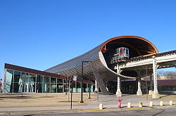
and Oak Park
(Harlem/Lake), through Chicago's Loop
, to the South Side and Englewood
(Ashland/63rd) and Woodlawn
(Cottage Grove/63rd). A 30th station at Morgan is slated to open in 2012. Average weekday ridership on the Green Line is 65,156 as of October 2009.
 Beginning at the yard and inspection facilities in Forest Park
, the Green Line runs east through Oak Park
towards the city on an embankment parallel to Metra
's Union Pacific/West Line
tracks from the Harlem Avenue terminal (7200 W. - 400 N.), on the border of Oak Park and River Forest, to a point just west of Laramie Avenue. Here the Green Line tracks leaves the railroad embankment and continues east on a steel elevated structure directly above Lake Street, a major east-west thoroughfare. The 'L' bridges a couple of railroad tracks before entering downtown Chicago at Clinton Street. East of Clinton Street, the route bridges Metra
's Union Pacific railroad tracks (which terminate just south of here at Ogilvie Transportation Center
) and the Chicago River
before joining the Union Loop
'L' tracks at Wells Street.
 In downtown Chicago, the Green Line operates over the famous Union Loop 'L' structure along with Brown Line
(Ravenswood), Orange Line
(Midway), Pink Line
(Douglas), and Purple Line
(Evanston Express during Weekday rush hours only) trains. However, Green Line trains operate both ways over the Lake Street and Wabash Avenue sides only, and does not use the Wells Street and Van Buren Street legs of the Loop.
The Green Line is the only line in the 'L' system that has multiple entry/exit points to the elevated Loop. Its route takes it over only the north and east portions of the Loop, which are used bidirectionally, as opposed to the Orange, Pink, Purple, and Brown Lines, which operate unidirectionally over the Loop and then return to their originating depots.
between the Loop and 17th Street. Passengers can transfer between the two lines at Roosevelt/Wabash station. The only other station on this section is at 35th–Bronzeville–IIT (which is 2.5 miles south of Roosevelt/Wabash) adjacent the Illinois Institute of Technology
campus and the Chicago Police Department
Headquarters. At 40th Street, the route turns east to Indiana station, then turns south between Calumet and Prairie Avenues to the Garfield station and continues south to 59th Street where the route splits into two branches—the Englewood (Ashland/63rd) Branch and the Jackson Park (East 63rd) Branch.
. The yard and inspection shop lie to the south between the old Racine Avenue station and the Ashland/63rd terminal. The 'L' tracks continues west to a stub end at Hermitage Avenue, a provision for a future extension of the route westward, however, those plans were cancelled in the late 1970s. Prior to 1992, the Englewood Branch had two additional stops at Wentworth and Harvard, but have been since closed due to service curtailments by the CTA
. Halsted/63rd is the only remaining intermediate stop on the 3.1 miles (5 km) route.
. South of here, the route curves east over 63rd Street and follows it to the current terminal at Cottage Grove/63rd (800 E. - 6300 S.). Prior to 1994, the Jackson Park Branch of the Green Line once terminated at University/63rd, and before that, at Stony Island
/63rd from 1893 to 1982. In addition to losing the University/63rd station, the Jackson Park Branch also lost the 61st Street station and the 58th Street station in 1994.
-built 5000-Series cars are delivered. (However, as of January 2011, most of these cars remain in regular service.) Occasionally, Morrison-Knudsen-built 3200-Series rail cars run on the Green Line, though these are loaned from the Brown and Orange Lines, and only appear when the Green Line is short on cars. 2600-Series cars (borrowed from the Blue and Pink Lines) can also be found occasionally on the Green line and operated for a reason very similar to the 3200-Series cars. Trains generally operate at 10 to 12 minute headways during much of the day (about 20 to 25 minutes on the Englewood and Jackson Park branches), with 4 to 6 car trains. There is no overnight service along the Green Line.
 The Green Line operates over the two oldest sections of the Chicago 'L'
. The South Side section started operation in 1892 when Chicago was preparing for the World's Columbian Exposition
of 1893 in Jackson Park. The initial section was built to provide service between downtown Chicago and the exposition site. This first section of the Chicago and South Side Rapid Transit Railroad between Wabash Avenue and State Street
went into service on June 6, 1892. It extended from Congress Street only as far south as 39th Street (Pershing Road). At that time a large part of the south side was little more than prairie, but by May 1, 1893, when the pioneer 'L' line was completed to Jackson Park, construction of homes, apartment buildings and commercial properties was booming in the area.
Continued expansion of the area development was reflected in construction of the Englewood, Normal Park, Kenwood
and Stock Yard branches of the South Side 'L' between 1905 and 1908. Of these, only the Englewood and Jackson Park branches remain: because of insufficient patronage, the Normal Park, Stock Yards and Kenwood branches were closed in the 1950s.
 The Lake Street Elevated
was Chicago's second rapid transit line. It began operation from a terminal at Madison
and Market
streets to Lake Street and California Avenue on November 6, 1893. The line was gradually extended westward to Laramie Avenue on April 29, 1894; to Austin Avenue on April 15, 1899; to Wisconsin Avenue, Oak Park
using street railway trackage on May 15, 1899 (closed in 1902), and to Marengo Avenue, Forest Park
, on May 14, 1910.
The construction of the Lake Street Elevated led to a political quarrel in suburban Cicero Township
, which at the time included Oak Park and Austin
. In 1898, Austinites, having a majority on Cicero's town council, used political influence to allow the extension of the Lake Street line from the city border at Laramie Avenue (then called 52nd Avenue) into their community. This infuriated other Cicero Township residents, who retaliated the following year by holding a joint election to force Austin's annexation to the City of Chicago. Much to the dismay of local residents, this effort succeeded, and Austin became part of Chicago in 1899. A century later, Oak Park commuters, who had come to depend on the service, were among the most vocal critics of the Green Line's closure for rehabilitation.
Between 1913 and 1993, the Englewood/Jackson Park branches were part of the North-South Route
in various service configurations operating from the north side through the Loop, and to the south side. On October 17, 1943, the Englewood and Jackson Park services were rerouted into the State Street Subway
to provide improved crosstown access through the heart of city and to alleviate congestion on the over-crowded Union Loop Elevated. On July 31, 1949, during the North-South rapid transit service revision by the CTA, the Howard-Englewood/Jackson Park route was created, operating via the State Street Subway.
On May 6, 1969, the Englewood branch was extended to the present South terminal at Ashland/63rd. In 1982, the Jackson Park branch was shortened to University Avenue because of structural deterioration at the Dorchester Bridge which carried the route across the Illinois Central Railroad
and the former Stony Island/63rd terminal was closed March 4, 1982.
The Lake Street 'L' would remain largely unchanged until 1948, when a number of its historic passenger stations were closed and subsequently demolished in an attempt to promote the "A" and "B" skip-stop express train service (discontinued in 1994). On October 28, 1962, the western two and one-half mile section of the line which operated at street level was elevated along the Chicago and Northwestern Railroad right-of-way opening new above-ground stops at Central, Austin, Ridgeland, Oak Park and Harlem/Lake, Forest Park. On September 28, 1969, the Lake Street line was combined with the new Dan Ryan Line to form the West-South Route, operating from Forest Park
through downtown via the Union Loop 'L' to 95th/Dan Ryan. The Lake-Dan Ryan routing was to fulfill the service implementation outlined in the 1968 Chicago Central Area Transit Plan
. However, when that controversial subway project was cancelled in 1979, Lake-Dan Ryan service remained, and lasted for nearly 24 years.
On February 21, 1993, the south side sections of the North-South and West-South routes were "switched" south of Roosevelt Road
, creating the present Red Line
(Howard-Dan Ryan) and the Green Line (Lake-Englewood/Jackson Park)
On January 9, 1994 the Green Line was closed for more than two years for the largest transit rehabilitation project in the city's history. It was reopened May 12, 1996 with much of the renewal work completed with the exception of a few stations. Several stations were closed indefinitely following the rehabilitation which angered many commuters who depend on the Green Line. In September 1997, after political pressure brought on by community organizations, the Jackson Park branch was shortened again from University Avenue to Cottage Grove/63rd (East 63rd) after previous attempts by the City, CTA and other agencies to extend the route eastward to Dorchester Avenue, immediately west of the Illinois Central Railroad
.
On April 26, 1998, the Green Line, like the Purple Line
and the Douglas branch of the Blue Line
lost its 24 hour service due to budget shortfalls and operates only between the hours of 4 a.m. and 1 a.m weekdays. The Green Line runs 6 a.m. Saturdays and 6:30 a.m. on Sundays
 The Green Line provides access to, among other destinations, the Garfield Park Conservatory
(Conservatory-Central Park Drive), United Center
(Ashland) James R. Thompson Center
, Richard J. Daley Center
and City Hall-Cook County Building
(Clark/Lake), Millennium Park
(Randolph/Wabash and Madison/Wabash), the Art Institute of Chicago
(Adams/Wabash), the Auditorium Building of Roosevelt University
, Museum Campus and Soldier Field
(Roosevelt/Wabash), the Illinois Institute of Technology
and U.S. Cellular Field
(White Sox Park) (35th–Bronzeville–IIT), the University of Chicago
(Garfield) and Kennedy-King College
(Halsted/63rd). The Clinton/Lake and Randolph/Wabash stops are useful for reaching Metra
and South Shore Line
trains at the Ogilvie Transportation Center
and Millennium Station.


Chicago Transit Authority
Chicago Transit Authority, also known as CTA, is the operator of mass transit within the City of Chicago, Illinois and some of its surrounding suburbs....
rapid transit
Rapid transit
A rapid transit, underground, subway, elevated railway, metro or metropolitan railway system is an electric passenger railway in an urban area with a high capacity and frequency, and grade separation from other traffic. Rapid transit systems are typically located either in underground tunnels or on...
system known as the Chicago 'L'
Chicago 'L'
The L is the rapid transit system serving the city of Chicago and some of its surrounding suburbs. It is operated by the Chicago Transit Authority...
. It is the only completely elevated route in the 'L' system. It utilizes the system's oldest segments (dating back to 1892), extending 20.8 miles (33.5 km) with 29 stops between Forest Park
Forest Park, Illinois
Forest Park is a village in Cook County, Illinois, a suburb of Chicago in the United States. The population was 15,688 at the 2000 census...
and Oak Park
Oak Park, Illinois
Oak Park, Illinois is a suburb bordering the west side of the city of Chicago in Cook County, Illinois, United States. It is the twenty-fifth largest municipality in Illinois. Oak Park has easy access to downtown Chicago due to public transportation such as the Chicago 'L' Blue and Green lines,...
(Harlem/Lake), through Chicago's Loop
Chicago Loop
The Loop or Chicago Loop is one of 77 officially designated Chicago community areas located in the City of Chicago, Illinois. It is the historic commercial center of downtown Chicago...
, to the South Side and Englewood
Englewood, Chicago
Englewood, once known as "Junction Grove" , is one of the 77 official community areas of Chicago. At its height, over 97,000 people lived in its approximately 3 square miles , but the neighborhood's population has since dropped dramatically...
(Ashland/63rd) and Woodlawn
Woodlawn, Chicago
Woodlawn, located in the South Side of the City of Chicago, Illinois, USA, is one of 77 well defined Chicago community areas. It is bounded by Lake Michigan to the east, 60th Street to the north, Martin Luther King Drive to the west, and, mostly, 67th Street to the south...
(Cottage Grove/63rd). A 30th station at Morgan is slated to open in 2012. Average weekday ridership on the Green Line is 65,156 as of October 2009.
Lake Street
Forest Park, Illinois
Forest Park is a village in Cook County, Illinois, a suburb of Chicago in the United States. The population was 15,688 at the 2000 census...
, the Green Line runs east through Oak Park
Oak Park, Illinois
Oak Park, Illinois is a suburb bordering the west side of the city of Chicago in Cook County, Illinois, United States. It is the twenty-fifth largest municipality in Illinois. Oak Park has easy access to downtown Chicago due to public transportation such as the Chicago 'L' Blue and Green lines,...
towards the city on an embankment parallel to Metra
Metra
Metra is the commuter rail division of the Illinois Regional Transportation Authority. The system serves Chicago and its metropolitan area through 240 stations on 11 different rail lines. Throughout the 21st century, Metra has been the second busiest commuter rail system in the United States by...
's Union Pacific/West Line
Union Pacific/West Line
The Union Pacific/West is a commuter rail line provided by Metra and operated by the Union Pacific Railroad in Chicago, Illinois, and its surrounding suburbs...
tracks from the Harlem Avenue terminal (7200 W. - 400 N.), on the border of Oak Park and River Forest, to a point just west of Laramie Avenue. Here the Green Line tracks leaves the railroad embankment and continues east on a steel elevated structure directly above Lake Street, a major east-west thoroughfare. The 'L' bridges a couple of railroad tracks before entering downtown Chicago at Clinton Street. East of Clinton Street, the route bridges Metra
Metra
Metra is the commuter rail division of the Illinois Regional Transportation Authority. The system serves Chicago and its metropolitan area through 240 stations on 11 different rail lines. Throughout the 21st century, Metra has been the second busiest commuter rail system in the United States by...
's Union Pacific railroad tracks (which terminate just south of here at Ogilvie Transportation Center
Ogilvie Transportation Center
The Richard B. Ogilvie Transportation Center is a passenger terminal in downtown Chicago, Illinois, USA, serving the three commuter rail lines of Metra's Union Pacific District, which approach the terminal elevated above street level. It occupies the lower floors of the Citigroup Center...
) and the Chicago River
Chicago River
The Chicago River is a system of rivers and canals with a combined length of that runs through the city of the same name, including its center . Though not especially long, the river is notable for being the reason why Chicago became an important location, as the link between the Great Lakes and...
before joining the Union Loop
Chicago Loop
The Loop or Chicago Loop is one of 77 officially designated Chicago community areas located in the City of Chicago, Illinois. It is the historic commercial center of downtown Chicago...
'L' tracks at Wells Street.
The Loop
Brown Line (Chicago Transit Authority)
The Brown Line starts out in northwest Chicago, at the Kimball and Lawrence Avenue terminal in Albany Park, where there is a storage yard and servicing shop for the trains to the east of the passenger station...
(Ravenswood), Orange Line
Orange Line (Chicago Transit Authority)
The Orange Line, is a rapid transit line in Chicago, Illinois run by the Chicago Transit Authority as part of the 'L' system. It is approximately long, and runs below grade and elevated on existing railroad embankments and new concrete and steel structures from Chicago Midway International...
(Midway), Pink Line
Pink Line (Chicago Transit Authority)
The Pink Line is a rapid transit line in Chicago, run by the Chicago Transit Authority as part of the Chicago 'L' system. It began operation for a 180-day trial period on June 25, 2006, running between 54th/Cermak Station in Cicero, Illinois and the Loop in downtown Chicago...
(Douglas), and Purple Line
Purple Line (Chicago Transit Authority)
The Purple Line of the Chicago Transit Authority is a branch line on the northernmost section of the Chicago 'L' rapid transit network. Normally, it extends south from the Wilmette terminal at Linden Avenue, passing through Evanston to Howard Street, on Chicago's northern city limits...
(Evanston Express during Weekday rush hours only) trains. However, Green Line trains operate both ways over the Lake Street and Wabash Avenue sides only, and does not use the Wells Street and Van Buren Street legs of the Loop.
The Green Line is the only line in the 'L' system that has multiple entry/exit points to the elevated Loop. Its route takes it over only the north and east portions of the Loop, which are used bidirectionally, as opposed to the Orange, Pink, Purple, and Brown Lines, which operate unidirectionally over the Loop and then return to their originating depots.
South Side Mainline
Leaving the Loop, the route heads south along Wabash Avenue and follows an "S" curve (which was realigned in 2002) to the west and south now following the alley between Wabash Avenue and State Street to 40th Street. This 3.8 mile section is the oldest part of Chicago's 'L' system. On this segment, the Green Line shares tracks with the Orange LineOrange Line (Chicago Transit Authority)
The Orange Line, is a rapid transit line in Chicago, Illinois run by the Chicago Transit Authority as part of the 'L' system. It is approximately long, and runs below grade and elevated on existing railroad embankments and new concrete and steel structures from Chicago Midway International...
between the Loop and 17th Street. Passengers can transfer between the two lines at Roosevelt/Wabash station. The only other station on this section is at 35th–Bronzeville–IIT (which is 2.5 miles south of Roosevelt/Wabash) adjacent the Illinois Institute of Technology
Illinois Institute of Technology
Illinois Institute of Technology, commonly called Illinois Tech or IIT, is a private Ph.D.-granting university located in Chicago, Illinois, with programs in engineering, science, psychology, architecture, business, communications, industrial technology, information technology, design, and law...
campus and the Chicago Police Department
Chicago Police Department
The Chicago Police Department, also known as the CPD, is the principal law enforcement agency of Chicago, Illinois, in the United States, under the jurisdiction of the Mayor of Chicago. It is the largest police department in the Midwest and the second largest local law enforcement agency in the...
Headquarters. At 40th Street, the route turns east to Indiana station, then turns south between Calumet and Prairie Avenues to the Garfield station and continues south to 59th Street where the route splits into two branches—the Englewood (Ashland/63rd) Branch and the Jackson Park (East 63rd) Branch.
Englewood Branch
The Englewood Branch continues south and west following 59th Street, Princeton Avenue and 63rd Street to the Ashland Avenue terminal (1600 W. - 6300 S.) in West EnglewoodWest Englewood, Chicago
West Englewood, one of the 77 well defined community areas, is located on the southwest side of Chicago, Illinois. At one time it was known as South Lynne. The boundaries of West Englewood are Garfield Blvd to the north, Racine Ave to the east, the CSX and Norfolk Southern RR tracks to the west,...
. The yard and inspection shop lie to the south between the old Racine Avenue station and the Ashland/63rd terminal. The 'L' tracks continues west to a stub end at Hermitage Avenue, a provision for a future extension of the route westward, however, those plans were cancelled in the late 1970s. Prior to 1992, the Englewood Branch had two additional stops at Wentworth and Harvard, but have been since closed due to service curtailments by the CTA
Chicago Transit Authority
Chicago Transit Authority, also known as CTA, is the operator of mass transit within the City of Chicago, Illinois and some of its surrounding suburbs....
. Halsted/63rd is the only remaining intermediate stop on the 3.1 miles (5 km) route.
Jackson Park Branch
The Jackson Park Branch continues south from the mainline between Calumet and Prairie Avenues, passing the old yard and inspection facilities at 61st Street in Washington ParkWashington Park, Chicago
Washington Park is a well-defined community area on the South Side of Chicago in Cook County, Illinois, USA, Which gets its name from the and nieghborhood. It includes the 372 acre park named Washington Park, stretching east-west from Cottage Grove Avenue to the Dan Ryan Expressway, and...
. South of here, the route curves east over 63rd Street and follows it to the current terminal at Cottage Grove/63rd (800 E. - 6300 S.). Prior to 1994, the Jackson Park Branch of the Green Line once terminated at University/63rd, and before that, at Stony Island
Stony Island Avenue
Stony Island Avenue is a major thoroughfare on South Side of the city of Chicago, designated 1600 East in Chicago's street numbering system. It runs from 56th Street south to the Calumet River. Stony Island Avenue continues sporadically south of the Calumet in the southern suburbs, running...
/63rd from 1893 to 1982. In addition to losing the University/63rd station, the Jackson Park Branch also lost the 61st Street station and the 58th Street station in 1994.
Operating fleet
Currently, the Green Line is operated only with Boeing-Vertol-built 2400-Series rail cars which were delivered between 1976 and 1978. These cars are scheduled for retirement in 2010 when the new BombardierBombardier Transportation
Bombardier Transportation is the rail equipment division of the Canadian firm, Bombardier Inc. Bombardier Transportation is one of the world's largest companies in the rail-equipment manufacturing and servicing industry. Its headquarters are in Berlin, Germany....
-built 5000-Series cars are delivered. (However, as of January 2011, most of these cars remain in regular service.) Occasionally, Morrison-Knudsen-built 3200-Series rail cars run on the Green Line, though these are loaned from the Brown and Orange Lines, and only appear when the Green Line is short on cars. 2600-Series cars (borrowed from the Blue and Pink Lines) can also be found occasionally on the Green line and operated for a reason very similar to the 3200-Series cars. Trains generally operate at 10 to 12 minute headways during much of the day (about 20 to 25 minutes on the Englewood and Jackson Park branches), with 4 to 6 car trains. There is no overnight service along the Green Line.
History
Chicago 'L'
The L is the rapid transit system serving the city of Chicago and some of its surrounding suburbs. It is operated by the Chicago Transit Authority...
. The South Side section started operation in 1892 when Chicago was preparing for the World's Columbian Exposition
World's Columbian Exposition
The World's Columbian Exposition was a World's Fair held in Chicago in 1893 to celebrate the 400th anniversary of Christopher Columbus's arrival in the New World in 1492. Chicago bested New York City; Washington, D.C.; and St...
of 1893 in Jackson Park. The initial section was built to provide service between downtown Chicago and the exposition site. This first section of the Chicago and South Side Rapid Transit Railroad between Wabash Avenue and State Street
State Street (Chicago)
State Street is a large south-north street in Chicago, Illinois, USA and its south suburbs. It begins on the Near North Side at North Avenue. For much of its course, it lies between Wabash Avenue on the east and Dearborn Street/Lafayette Avenue on the west...
went into service on June 6, 1892. It extended from Congress Street only as far south as 39th Street (Pershing Road). At that time a large part of the south side was little more than prairie, but by May 1, 1893, when the pioneer 'L' line was completed to Jackson Park, construction of homes, apartment buildings and commercial properties was booming in the area.
Continued expansion of the area development was reflected in construction of the Englewood, Normal Park, Kenwood
Kenwood branch (CTA)
The Kenwood branch is a defunct rapid transit line which was part of the Chicago 'L' system. The branch served the Kenwood neighborhood of Chicago and consisted of six elevated stations. It opened on September 20, 1907 and closed on December 1, 1957....
and Stock Yard branches of the South Side 'L' between 1905 and 1908. Of these, only the Englewood and Jackson Park branches remain: because of insufficient patronage, the Normal Park, Stock Yards and Kenwood branches were closed in the 1950s.
Lake Street Elevated Railroad
The Lake Street Elevated Railroad was the second permanent elevated rapid transit line to be constructed in Chicago, Illinois. The first section of the line opened on November 6, 1893, and its route is still used today as part of the Green Line route of the Chicago 'L' system.-Beginnings:The Lake...
was Chicago's second rapid transit line. It began operation from a terminal at Madison
Madison Street (Chicago)
Madison Street is a major east-west street in Chicago, Illinois. Prior to human intervention, the Chicago River emptied into Lake Michigan at the present day intersection of Madison Street and Michigan Avenue....
and Market
Wacker Drive
Wacker Drive is a major street in Chicago, Illinois, United States, running along the south side of the main branch and the east side of the south branch of the Chicago River...
streets to Lake Street and California Avenue on November 6, 1893. The line was gradually extended westward to Laramie Avenue on April 29, 1894; to Austin Avenue on April 15, 1899; to Wisconsin Avenue, Oak Park
Oak Park, Illinois
Oak Park, Illinois is a suburb bordering the west side of the city of Chicago in Cook County, Illinois, United States. It is the twenty-fifth largest municipality in Illinois. Oak Park has easy access to downtown Chicago due to public transportation such as the Chicago 'L' Blue and Green lines,...
using street railway trackage on May 15, 1899 (closed in 1902), and to Marengo Avenue, Forest Park
Forest Park, Illinois
Forest Park is a village in Cook County, Illinois, a suburb of Chicago in the United States. The population was 15,688 at the 2000 census...
, on May 14, 1910.
The construction of the Lake Street Elevated led to a political quarrel in suburban Cicero Township
Cicero, Illinois
Cicero is an incorporated town in Cook County, Illinois, United States. The population was 83,891 at the 2010 census. Cicero is named for the town of Cicero, New York, which in turn was named for Marcus Tullius Cicero, the Roman statesman and orator....
, which at the time included Oak Park and Austin
Austin, Chicago
Austin, located on the West Side of Chicago, Illinois, is the largest of the city's 77 officially defined community areas, followed by Lake View. Its eastern boundary is the Belt Railway located just east of Cicero Avenue. Its northernmost border is the Milwaukee District/West Line...
. In 1898, Austinites, having a majority on Cicero's town council, used political influence to allow the extension of the Lake Street line from the city border at Laramie Avenue (then called 52nd Avenue) into their community. This infuriated other Cicero Township residents, who retaliated the following year by holding a joint election to force Austin's annexation to the City of Chicago. Much to the dismay of local residents, this effort succeeded, and Austin became part of Chicago in 1899. A century later, Oak Park commuters, who had come to depend on the service, were among the most vocal critics of the Green Line's closure for rehabilitation.
Between 1913 and 1993, the Englewood/Jackson Park branches were part of the North-South Route
Red Line (Chicago Transit Authority)
The northern terminus of the Red Line is Howard Street in the Rogers Park neighborhood of Chicago , on the City Limits farthest north. The Red Line extends southeasterly on an elevated embankment structure about a half-mile west of the lakefront to Touhy Avenue then turns south along Glenwood...
in various service configurations operating from the north side through the Loop, and to the south side. On October 17, 1943, the Englewood and Jackson Park services were rerouted into the State Street Subway
Red Line (Chicago Transit Authority)
The northern terminus of the Red Line is Howard Street in the Rogers Park neighborhood of Chicago , on the City Limits farthest north. The Red Line extends southeasterly on an elevated embankment structure about a half-mile west of the lakefront to Touhy Avenue then turns south along Glenwood...
to provide improved crosstown access through the heart of city and to alleviate congestion on the over-crowded Union Loop Elevated. On July 31, 1949, during the North-South rapid transit service revision by the CTA, the Howard-Englewood/Jackson Park route was created, operating via the State Street Subway.
On May 6, 1969, the Englewood branch was extended to the present South terminal at Ashland/63rd. In 1982, the Jackson Park branch was shortened to University Avenue because of structural deterioration at the Dorchester Bridge which carried the route across the Illinois Central Railroad
Illinois Central Railroad
The Illinois Central Railroad , sometimes called the Main Line of Mid-America, is a railroad in the central United States, with its primary routes connecting Chicago, Illinois with New Orleans, Louisiana and Birmingham, Alabama. A line also connected Chicago with Sioux City, Iowa...
and the former Stony Island/63rd terminal was closed March 4, 1982.
The Lake Street 'L' would remain largely unchanged until 1948, when a number of its historic passenger stations were closed and subsequently demolished in an attempt to promote the "A" and "B" skip-stop express train service (discontinued in 1994). On October 28, 1962, the western two and one-half mile section of the line which operated at street level was elevated along the Chicago and Northwestern Railroad right-of-way opening new above-ground stops at Central, Austin, Ridgeland, Oak Park and Harlem/Lake, Forest Park. On September 28, 1969, the Lake Street line was combined with the new Dan Ryan Line to form the West-South Route, operating from Forest Park
Forest Park, Illinois
Forest Park is a village in Cook County, Illinois, a suburb of Chicago in the United States. The population was 15,688 at the 2000 census...
through downtown via the Union Loop 'L' to 95th/Dan Ryan. The Lake-Dan Ryan routing was to fulfill the service implementation outlined in the 1968 Chicago Central Area Transit Plan
Chicago Central Area Transit Plan
The Chicago Central Area Transit Plan, or generally referred to as the Chicago Central Area Transit Project in the 1970s, was an extensive study of the rapid transit system in downtown Chicago; the study had begun in 1965....
. However, when that controversial subway project was cancelled in 1979, Lake-Dan Ryan service remained, and lasted for nearly 24 years.
On February 21, 1993, the south side sections of the North-South and West-South routes were "switched" south of Roosevelt Road
Roosevelt Road
Roosevelt Road is a major east-west thoroughfare in the city of Chicago, Illinois, and its western suburbs. It is 1200 South in the city's street numbering system, but only one mile south of Madison Street...
, creating the present Red Line
Red Line (Chicago Transit Authority)
The northern terminus of the Red Line is Howard Street in the Rogers Park neighborhood of Chicago , on the City Limits farthest north. The Red Line extends southeasterly on an elevated embankment structure about a half-mile west of the lakefront to Touhy Avenue then turns south along Glenwood...
(Howard-Dan Ryan) and the Green Line (Lake-Englewood/Jackson Park)
On January 9, 1994 the Green Line was closed for more than two years for the largest transit rehabilitation project in the city's history. It was reopened May 12, 1996 with much of the renewal work completed with the exception of a few stations. Several stations were closed indefinitely following the rehabilitation which angered many commuters who depend on the Green Line. In September 1997, after political pressure brought on by community organizations, the Jackson Park branch was shortened again from University Avenue to Cottage Grove/63rd (East 63rd) after previous attempts by the City, CTA and other agencies to extend the route eastward to Dorchester Avenue, immediately west of the Illinois Central Railroad
Illinois Central Railroad
The Illinois Central Railroad , sometimes called the Main Line of Mid-America, is a railroad in the central United States, with its primary routes connecting Chicago, Illinois with New Orleans, Louisiana and Birmingham, Alabama. A line also connected Chicago with Sioux City, Iowa...
.
On April 26, 1998, the Green Line, like the Purple Line
Purple Line (Chicago Transit Authority)
The Purple Line of the Chicago Transit Authority is a branch line on the northernmost section of the Chicago 'L' rapid transit network. Normally, it extends south from the Wilmette terminal at Linden Avenue, passing through Evanston to Howard Street, on Chicago's northern city limits...
and the Douglas branch of the Blue Line
Blue Line (Chicago Transit Authority)
The Blue Line consists of a long trunk line in the Chicago Transit Authority's rapid transit system which extends through Chicago's Loop from O'Hare International Airport at the far northwest end of the city, through downtown via the Milwaukee-Dearborn subway, and across the West Side to its...
lost its 24 hour service due to budget shortfalls and operates only between the hours of 4 a.m. and 1 a.m weekdays. The Green Line runs 6 a.m. Saturdays and 6:30 a.m. on Sundays
Incidents
On May 28, 2008, a derailment was reported, with approximately 24 injuries. Two train cars on the four-car train appeared to be derailed, with the leading car abutting the one behind it at an angle of approximately 150 degrees. The train cars were separated at a switching point near 59th Street.Points of interest
Garfield Park Conservatory
Garfield Park is a site located in the East Garfield Park neighborhood on Chicago's West Side. It was designed as a pleasure ground by William LeBaron Jenney and is the oldest of the three great original Chicago West Side parks .It is home to the Garfield Park Conservatory, one of the largest and...
(Conservatory-Central Park Drive), United Center
United Center
The United Center is an indoor sports arena located in Chicago. It is named after its corporate sponsor, United Airlines. The United Center is home to both the Chicago Bulls of the National Basketball Association and the Chicago Blackhawks of the National Hockey League...
(Ashland) James R. Thompson Center
James R. Thompson Center
The James R. Thompson Center is located at 100 W. Randolph Street in the Loop, Chicago, Illinois and houses offices of the State of Illinois. The building opened in May 1985 as the State of Illinois Center. It was renamed in 1993 to honor former Illinois Governor James R. Thompson...
, Richard J. Daley Center
Richard J. Daley Center
The Richard J. Daley Center, also known by its courtyard Daley Plaza and named after longtime mayor Richard J. Daley, is the premier civic center of the City of Chicago in Illinois. Situated on Randolph and Washington Streets between Dearborn and Clark Streets, the Richard J. Daley Center is...
and City Hall-Cook County Building
Chicago City Hall
Chicago City Hall is the official seat of government of the City of Chicago in Illinois. Adjacent to the Richard J. Daley Center and the James R...
(Clark/Lake), Millennium Park
Millennium Park
Millennium Park is a public park located in the Loop community area of Chicago in Illinois, USA and originally intended to celebrate the millennium. It is a prominent civic center near the city's Lake Michigan shoreline that covers a section of northwestern Grant Park. The area was previously...
(Randolph/Wabash and Madison/Wabash), the Art Institute of Chicago
Art Institute of Chicago
The School of the Art Institute of Chicago is one of America's largest accredited independent schools of art and design, located in the Loop in Chicago, Illinois. It is associated with the museum of the same name, and "The Art Institute of Chicago" or "Chicago Art Institute" often refers to either...
(Adams/Wabash), the Auditorium Building of Roosevelt University
Roosevelt University
Roosevelt University is a coeducational, private university with campuses in Chicago, Illinois and Schaumburg, Illinois. Founded in 1945, the university is named in honor of both former President Franklin Delano Roosevelt and First Lady Eleanor Roosevelt. The university's curriculum is based on...
, Museum Campus and Soldier Field
Soldier Field
Soldier Field is located on Lake Shore Drive in Chicago, Illinois, United States, in the Near South Side. It is home to the NFL's Chicago Bears...
(Roosevelt/Wabash), the Illinois Institute of Technology
Illinois Institute of Technology
Illinois Institute of Technology, commonly called Illinois Tech or IIT, is a private Ph.D.-granting university located in Chicago, Illinois, with programs in engineering, science, psychology, architecture, business, communications, industrial technology, information technology, design, and law...
and U.S. Cellular Field
U.S. Cellular Field
U.S. Cellular Field is a baseball ballpark in Chicago, Illinois. Owned by the Illinois Sports Facilities Authority, it is the home of the Chicago White Sox of Major League Baseball's American League. The park opened for the 1991 season, after the White Sox had spent 81 years at old Comiskey Park...
(White Sox Park) (35th–Bronzeville–IIT), the University of Chicago
University of Chicago
The University of Chicago is a private research university in Chicago, Illinois, USA. It was founded by the American Baptist Education Society with a donation from oil magnate and philanthropist John D. Rockefeller and incorporated in 1890...
(Garfield) and Kennedy-King College
Kennedy-King College
Kennedy-King College is a two-year community college in Chicago, Illinois, United States. It is part of the City Colleges of Chicago, a system of two-year education that has existed in Chicago, Illinois since Crane Technical College began to accept adult students in 1911...
(Halsted/63rd). The Clinton/Lake and Randolph/Wabash stops are useful for reaching Metra
Metra
Metra is the commuter rail division of the Illinois Regional Transportation Authority. The system serves Chicago and its metropolitan area through 240 stations on 11 different rail lines. Throughout the 21st century, Metra has been the second busiest commuter rail system in the United States by...
and South Shore Line
South Shore Line (NICTD)
The South Shore Line is an electrically powered interurban commuter rail line operated by the Northern Indiana Commuter Transportation District between Millennium Station in downtown Chicago and the South Bend Regional Airport in South Bend, Indiana...
trains at the Ogilvie Transportation Center
Ogilvie Transportation Center
The Richard B. Ogilvie Transportation Center is a passenger terminal in downtown Chicago, Illinois, USA, serving the three commuter rail lines of Metra's Union Pacific District, which approach the terminal elevated above street level. It occupies the lower floors of the Citigroup Center...
and Millennium Station.
Station Listing
| Green Line (Lake Street Elevated) | ||
|---|---|---|
| Station | Location | Points of interest and notes |
| Forest Park | Marengo Avenue and Circle Avenue, Forest Park | Closed 1962 |
| Harlem |
1 S. Harlem Avenue, Forest Park | Downtown Oak Park Oak Park, Illinois Oak Park, Illinois is a suburb bordering the west side of the city of Chicago in Cook County, Illinois, United States. It is the twenty-fifth largest municipality in Illinois. Oak Park has easy access to downtown Chicago due to public transportation such as the Chicago 'L' Blue and Green lines,... , transfer to Oak Park (Metra) Oak Park (Metra) Oak Park is a Metra commuter railroad station in Oak Park, Illinois, just west of Chicago. It is served by Metra's Union Pacific/West Line, with service east to Ogilvie Transportation Center in Chicago and as far west as Elburn, Illinois. Travel time to Chicago is 16 to 20 minutes... , Forest Preserve District of Cook County Headquarters Cook County Forest Preserves The Cook County Forest Preserves are a network of open spaces, containing forest, prairie, wetland, streams, and lakes, that are set aside as natural areas. Cook County contains Chicago, Illinois, and is the center of a densely-populated urban metropolitan area in northeastern Illinois... |
| Marion | Marion Avenue and South Boulevard, Oak Park | Closed October 28, 1962 |
| Oak Park | 100 S. Oak Park Avenue, Oak Park | Oak Park Oak Park, Illinois Oak Park, Illinois is a suburb bordering the west side of the city of Chicago in Cook County, Illinois, United States. It is the twenty-fifth largest municipality in Illinois. Oak Park has easy access to downtown Chicago due to public transportation such as the Chicago 'L' Blue and Green lines,... , Frank Lloyd Wright Home and Studio Frank Lloyd Wright Home and Studio The Frank Lloyd Wright Home and Studio at 951 Chicago Avenue in Oak Park, Illinois, has been restored by the Frank Lloyd Wright Preservation Trust to its appearance in 1909, the last year Frank Lloyd Wright lived there with his family. Frank Lloyd Wright purchased the property and built the home in... , Unity Temple Unity Temple Unity Temple is a Unitarian Universalist church in Oak Park, Illinois, and the home of the Unity Temple Unitarian Universalist Congregation. It was designed by the American architect Frank Lloyd Wright, and built between 1905 and 1908. Unity Temple is considered to be one of Wright's most important... , Ernest Hemingway Ernest Hemingway Ernest Miller Hemingway was an American author and journalist. His economic and understated style had a strong influence on 20th-century fiction, while his life of adventure and his public image influenced later generations. Hemingway produced most of his work between the mid-1920s and the... Museum & Brithplace |
| Ridgeland | 100 N. Ridgeland Avenue, Oak Park | Oak Park and River Forest High School Oak Park and River Forest High School Oak Park and River Forest High School, or OPRF, is a public four-year high school located in Oak Park, Illinois, a western suburb of Chicago, Illinois, in the United States. It is the only school of Oak Park and River Forest District 200.... , Oak Park Oak Park, Illinois Oak Park, Illinois is a suburb bordering the west side of the city of Chicago in Cook County, Illinois, United States. It is the twenty-fifth largest municipality in Illinois. Oak Park has easy access to downtown Chicago due to public transportation such as the Chicago 'L' Blue and Green lines,... , |
| Lombard | Lombard Avenue and South Boulevard, Oak Park | Closed 1948 |
| Austin | 351 N. Austin Boulevard | |
| Menard | Menard Avenue and Lake Street | Closed 1948 |
| Central | 350 N. Central Avenue | Columbus Park Columbus Park (Chicago) Columbus Park, located on the west side of Chicago, Illinois in the Austin neighborhood, is bounded by West Adams Street, South Austin Boulevard, South Central Avenue, and the Eisenhower Expressway, to which it lost nine acres when the expressway was constructed. The remnant park is part of the... , Walser House, Austin Town Hall Austin Town Hall Park Austin Town Hall Park is a park at 5610 W. Lake Street in the Austin neighborhood of Chicago, Illinois. The site was formerly used for the town hall of Cicero Township. The Austin subdivision of Cicero was annexed to Chicago in 1899, and the town hall site eventually became part of the Chicago Park... , Loretto Hospital |
| Laramie | 5148 W. Lake Street Lake Street (Chicago) Lake Street is an east-west arterial road in Chicago and its suburbs. Part of Lake Street is designated as U.S. Route 20. Lake Street begins in the city of Chicago and travels west and slightly north to the Chicago suburbs. It ends at the eastern terminus of the Elgin Bypass around Elgin, where... |
|
| Cicero | 4800 W. Lake Street Lake Street (Chicago) Lake Street is an east-west arterial road in Chicago and its suburbs. Part of Lake Street is designated as U.S. Route 20. Lake Street begins in the city of Chicago and travels west and slightly north to the Chicago suburbs. It ends at the eastern terminus of the Elgin Bypass around Elgin, where... |
Former Brach's Candy Factory |
| Kostner | Kostner Avenue and Lake Street | Closed 1948 |
| Pulaski | 4000 W. Lake Street Lake Street (Chicago) Lake Street is an east-west arterial road in Chicago and its suburbs. Part of Lake Street is designated as U.S. Route 20. Lake Street begins in the city of Chicago and travels west and slightly north to the Chicago suburbs. It ends at the eastern terminus of the Elgin Bypass around Elgin, where... |
Chicago Public Library Legler Branch |
| Hamlin | 3800 W. Lake St. | Closed March 18, 1956 |
| Conservatory-Central Park Drive | 3630 W. Lake Street Lake Street (Chicago) Lake Street is an east-west arterial road in Chicago and its suburbs. Part of Lake Street is designated as U.S. Route 20. Lake Street begins in the city of Chicago and travels west and slightly north to the Chicago suburbs. It ends at the eastern terminus of the Elgin Bypass around Elgin, where... |
Garfield Park Conservatory Garfield Park Conservatory Garfield Park is a site located in the East Garfield Park neighborhood on Chicago's West Side. It was designed as a pleasure ground by William LeBaron Jenney and is the oldest of the three great original Chicago West Side parks .It is home to the Garfield Park Conservatory, one of the largest and... , Garfield Park Field house |
| Homan Homan (CTA Green Line station) Homan was a station on the Chicago Transit Authority's Green Line. The station was located at Homan Avenue and Lake Street in the East Garfield Park neighborhood of Chicago. Homan was situated east of Pulaski and west of Kedzie. Cermak opened in March, 1894 and closed on January 9, 1994 when the... |
3400 W. Lake Street Lake Street (Chicago) Lake Street is an east-west arterial road in Chicago and its suburbs. Part of Lake Street is designated as U.S. Route 20. Lake Street begins in the city of Chicago and travels west and slightly north to the Chicago suburbs. It ends at the eastern terminus of the Elgin Bypass around Elgin, where... |
Closed January 9, 1994; replaced by Conservatory-Central Park Drive |
| Kedzie |
3200 W. Lake Street Lake Street (Chicago) Lake Street is an east-west arterial road in Chicago and its suburbs. Part of Lake Street is designated as U.S. Route 20. Lake Street begins in the city of Chicago and travels west and slightly north to the Chicago suburbs. It ends at the eastern terminus of the Elgin Bypass around Elgin, where... |
Transfer to Kedzie (Metra) Kedzie (Metra) Kedzie is a Metra commuter railroad station in the Garfield Park neighborhood on the West Side of Chicago. It is served by the Union Pacific/West Line.... |
| Sacramento | Sacramento Boulevard and Lake Street Lake Street (Chicago) Lake Street is an east-west arterial road in Chicago and its suburbs. Part of Lake Street is designated as U.S. Route 20. Lake Street begins in the city of Chicago and travels west and slightly north to the Chicago suburbs. It ends at the eastern terminus of the Elgin Bypass around Elgin, where... |
Closed 1948 |
| California | 2800 W. Lake Street Lake Street (Chicago) Lake Street is an east-west arterial road in Chicago and its suburbs. Part of Lake Street is designated as U.S. Route 20. Lake Street begins in the city of Chicago and travels west and slightly north to the Chicago suburbs. It ends at the eastern terminus of the Elgin Bypass around Elgin, where... |
Chicago Center for Green Technology Chicago Center for Green Technology The Chicago Center for Green Technology is a US Green Building Council LEED Platinum certified building located on a plot of in Chicago’s East Garfield Park Community built to showcase green technologies. This was the first municipal and brownfield site to win a LEED Platinum award . This... |
| Campbell | Campbell Avenue and Lake Street Lake Street (Chicago) Lake Street is an east-west arterial road in Chicago and its suburbs. Part of Lake Street is designated as U.S. Route 20. Lake Street begins in the city of Chicago and travels west and slightly north to the Chicago suburbs. It ends at the eastern terminus of the Elgin Bypass around Elgin, where... |
Closed 1948 |
| Oakley | Oakley Boulevard and Lake Street Lake Street (Chicago) Lake Street is an east-west arterial road in Chicago and its suburbs. Part of Lake Street is designated as U.S. Route 20. Lake Street begins in the city of Chicago and travels west and slightly north to the Chicago suburbs. It ends at the eastern terminus of the Elgin Bypass around Elgin, where... |
Closed 1948 |
| Damen | Damen Avenue and Lake Street Lake Street (Chicago) Lake Street is an east-west arterial road in Chicago and its suburbs. Part of Lake Street is designated as U.S. Route 20. Lake Street begins in the city of Chicago and travels west and slightly north to the Chicago suburbs. It ends at the eastern terminus of the Elgin Bypass around Elgin, where... |
Closed 1948 |
| Wood | Wood Street and Lake Street Lake Street (Chicago) Lake Street is an east-west arterial road in Chicago and its suburbs. Part of Lake Street is designated as U.S. Route 20. Lake Street begins in the city of Chicago and travels west and slightly north to the Chicago suburbs. It ends at the eastern terminus of the Elgin Bypass around Elgin, where... |
Closed 1913 |
| Lake Street Transfer | Lake Street Lake Street (Chicago) Lake Street is an east-west arterial road in Chicago and its suburbs. Part of Lake Street is designated as U.S. Route 20. Lake Street begins in the city of Chicago and travels west and slightly north to the Chicago suburbs. It ends at the eastern terminus of the Elgin Bypass around Elgin, where... and Paulina Street |
Closed February 25, 1951 |
| Ashland | 1601 W. Lake Street Lake Street (Chicago) Lake Street is an east-west arterial road in Chicago and its suburbs. Part of Lake Street is designated as U.S. Route 20. Lake Street begins in the city of Chicago and travels west and slightly north to the Chicago suburbs. It ends at the eastern terminus of the Elgin Bypass around Elgin, where... |
Transfer to Pink Line Pink Line (Chicago Transit Authority) The Pink Line is a rapid transit line in Chicago, run by the Chicago Transit Authority as part of the Chicago 'L' system. It began operation for a 180-day trial period on June 25, 2006, running between 54th/Cermak Station in Cicero, Illinois and the Loop in downtown Chicago... trains. United Center United Center The United Center is an indoor sports arena located in Chicago. It is named after its corporate sponsor, United Airlines. The United Center is home to both the Chicago Bulls of the National Basketball Association and the Chicago Blackhawks of the National Hockey League... , Union Park Pitchfork Music Festival The Pitchfork Music Festival is an annual summer music festival organized by Pitchfork Media and held in Union Park in Chicago, IL. The festival, which is normally held over three days in July, focuses primarily on artists and bands from alternative rock, rap & hip-hop, electronica, and dance... |
| Loomis | Loomis Street and Lake Street Lake Street (Chicago) Lake Street is an east-west arterial road in Chicago and its suburbs. Part of Lake Street is designated as U.S. Route 20. Lake Street begins in the city of Chicago and travels west and slightly north to the Chicago suburbs. It ends at the eastern terminus of the Elgin Bypass around Elgin, where... |
Closed April 4, 1954 |
| Racine | Racine Street and Lake Street Lake Street (Chicago) Lake Street is an east-west arterial road in Chicago and its suburbs. Part of Lake Street is designated as U.S. Route 20. Lake Street begins in the city of Chicago and travels west and slightly north to the Chicago suburbs. It ends at the eastern terminus of the Elgin Bypass around Elgin, where... |
Closed 1948 |
| Morgan | Morgan Street and Lake Street Lake Street (Chicago) Lake Street is an east-west arterial road in Chicago and its suburbs. Part of Lake Street is designated as U.S. Route 20. Lake Street begins in the city of Chicago and travels west and slightly north to the Chicago suburbs. It ends at the eastern terminus of the Elgin Bypass around Elgin, where... |
Closed 1948; Scheduled to reopen in 2012. |
| Halsted | 800 W. Lake Street Lake Street (Chicago) Lake Street is an east-west arterial road in Chicago and its suburbs. Part of Lake Street is designated as U.S. Route 20. Lake Street begins in the city of Chicago and travels west and slightly north to the Chicago suburbs. It ends at the eastern terminus of the Elgin Bypass around Elgin, where... |
Closed January 9, 1994 |
| Clinton |
540 W. Lake Street Lake Street (Chicago) Lake Street is an east-west arterial road in Chicago and its suburbs. Part of Lake Street is designated as U.S. Route 20. Lake Street begins in the city of Chicago and travels west and slightly north to the Chicago suburbs. It ends at the eastern terminus of the Elgin Bypass around Elgin, where... |
Ogilvie Transportation Center Ogilvie Transportation Center The Richard B. Ogilvie Transportation Center is a passenger terminal in downtown Chicago, Illinois, USA, serving the three commuter rail lines of Metra's Union Pacific District, which approach the terminal elevated above street level. It occupies the lower floors of the Citigroup Center... and Chicago Transit Authority Chicago Transit Authority Chicago Transit Authority, also known as CTA, is the operator of mass transit within the City of Chicago, Illinois and some of its surrounding suburbs.... Headquarters |
| Canal | 500 W. Lake Street Lake Street (Chicago) Lake Street is an east-west arterial road in Chicago and its suburbs. Part of Lake Street is designated as U.S. Route 20. Lake Street begins in the city of Chicago and travels west and slightly north to the Chicago suburbs. It ends at the eastern terminus of the Elgin Bypass around Elgin, where... |
Closed 1909 |
| Green Line (loop) | ||
| Station | Location | Points of interest and notes |
| Fifth/Lake | Wells Street Wells Street (Chicago) Wells Street is a main North–South road in downtown Chicago. It is officially designated as 200 West, and is named in honor of William Wells, a United States Army Captain who died in the Battle of Fort Dearborn.... and Lake Street Lake Street (Chicago) Lake Street is an east-west arterial road in Chicago and its suburbs. Part of Lake Street is designated as U.S. Route 20. Lake Street begins in the city of Chicago and travels west and slightly north to the Chicago suburbs. It ends at the eastern terminus of the Elgin Bypass around Elgin, where... |
Closed December 17, 1899 |
| Clark/Lake | 100/124 W. Lake Street Lake Street (Chicago) Lake Street is an east-west arterial road in Chicago and its suburbs. Part of Lake Street is designated as U.S. Route 20. Lake Street begins in the city of Chicago and travels west and slightly north to the Chicago suburbs. It ends at the eastern terminus of the Elgin Bypass around Elgin, where... |
Transfer to Orange Orange Line (Chicago Transit Authority) The Orange Line, is a rapid transit line in Chicago, Illinois run by the Chicago Transit Authority as part of the 'L' system. It is approximately long, and runs below grade and elevated on existing railroad embankments and new concrete and steel structures from Chicago Midway International... , Blue Blue Line (Chicago Transit Authority) The Blue Line consists of a long trunk line in the Chicago Transit Authority's rapid transit system which extends through Chicago's Loop from O'Hare International Airport at the far northwest end of the city, through downtown via the Milwaukee-Dearborn subway, and across the West Side to its... , Purple Purple Line (Chicago Transit Authority) The Purple Line of the Chicago Transit Authority is a branch line on the northernmost section of the Chicago 'L' rapid transit network. Normally, it extends south from the Wilmette terminal at Linden Avenue, passing through Evanston to Howard Street, on Chicago's northern city limits... , Brown Brown Line (Chicago Transit Authority) The Brown Line starts out in northwest Chicago, at the Kimball and Lawrence Avenue terminal in Albany Park, where there is a storage yard and servicing shop for the trains to the east of the passenger station... , and Pink Line Pink Line (Chicago Transit Authority) The Pink Line is a rapid transit line in Chicago, run by the Chicago Transit Authority as part of the Chicago 'L' system. It began operation for a 180-day trial period on June 25, 2006, running between 54th/Cermak Station in Cicero, Illinois and the Loop in downtown Chicago... trains |
| State/Lake | 200 N. State Street State Street (Chicago) State Street is a large south-north street in Chicago, Illinois, USA and its south suburbs. It begins on the Near North Side at North Avenue. For much of its course, it lies between Wabash Avenue on the east and Dearborn Street/Lafayette Avenue on the west... |
Transfer to Red Line Red Line (Chicago Transit Authority) The northern terminus of the Red Line is Howard Street in the Rogers Park neighborhood of Chicago , on the City Limits farthest north. The Red Line extends southeasterly on an elevated embankment structure about a half-mile west of the lakefront to Touhy Avenue then turns south along Glenwood... trains |
| Randolph/Wabash |
151 N. Wabash Avenue | Chicago Cultural Center Chicago Cultural Center The Chicago Cultural Center, opened in 1897, is a Chicago Landmark building that houses the city's official reception venue where the Mayor of Chicago has welcomed Presidents and royalty, diplomats and community leaders. It is located in the Loop, across Michigan Avenue from Millennium Park... , Millennium Park Millennium Park Millennium Park is a public park located in the Loop community area of Chicago in Illinois, USA and originally intended to celebrate the millennium. It is a prominent civic center near the city's Lake Michigan shoreline that covers a section of northwestern Grant Park. The area was previously... Transfer station for Millennium Station (Metra Electric Metra Electric Line The Metra Electric District is an electrified commuter rail line owned and operated by Metra which connects Millennium Station in downtown Chicago, with the city's southern suburbs... and South Shore Line South Shore Line (NICTD) The South Shore Line is an electrically powered interurban commuter rail line operated by the Northern Indiana Commuter Transportation District between Millennium Station in downtown Chicago and the South Bend Regional Airport in South Bend, Indiana... trains) |
| Madison/Wabash | 2 N. Wabash Avenue | Jewelers Row |
| Adams/Wabash | 201/223 S. Wabash Ave. | Grant Park Grant Park (Chicago) Grant Park, with between the downtown Chicago Loop and Lake Michigan, offers many different attractions in its large open space. The park is generally flat. It is also crossed by large boulevards and even a bed of sunken railroad tracks... , Petrillo Music Shell Petrillo Music Shell James C. Petrillo Music Shell or simply Petrillo Music Shell or Petrillo Bandshell as it is more commonly known, is an outdoor amphitheater/bandstand in Grant Park in the Loop community area of Chicago in Cook County, Illinois, United States... , Buckingham Fountain Buckingham Fountain Buckingham Fountain is a Chicago landmark in the center of Grant Park. Dedicated in 1927, it is one of the largest fountains in the world. Built in a rococo wedding cake style and inspired by the Latona Fountain at the Palace of Versailles, it is meant to allegorically represent Lake Michigan... , Art Institute of Chicago Art Institute of Chicago The School of the Art Institute of Chicago is one of America's largest accredited independent schools of art and design, located in the Loop in Chicago, Illinois. It is associated with the museum of the same name, and "The Art Institute of Chicago" or "Chicago Art Institute" often refers to either... , Orchestra Hall DePaul University DePaul University DePaul University is a private institution of higher education and research in Chicago, Illinois. Founded by the Vincentians in 1898, the university takes its name from the 17th century French priest Saint Vincent de Paul... Transfer to Orange Orange Line (Chicago Transit Authority) The Orange Line, is a rapid transit line in Chicago, Illinois run by the Chicago Transit Authority as part of the 'L' system. It is approximately long, and runs below grade and elevated on existing railroad embankments and new concrete and steel structures from Chicago Midway International... , Purple Purple Line (Chicago Transit Authority) The Purple Line of the Chicago Transit Authority is a branch line on the northernmost section of the Chicago 'L' rapid transit network. Normally, it extends south from the Wilmette terminal at Linden Avenue, passing through Evanston to Howard Street, on Chicago's northern city limits... , Brown Brown Line (Chicago Transit Authority) The Brown Line starts out in northwest Chicago, at the Kimball and Lawrence Avenue terminal in Albany Park, where there is a storage yard and servicing shop for the trains to the east of the passenger station... , and Pink Line Pink Line (Chicago Transit Authority) The Pink Line is a rapid transit line in Chicago, run by the Chicago Transit Authority as part of the Chicago 'L' system. It began operation for a 180-day trial period on June 25, 2006, running between 54th/Cermak Station in Cicero, Illinois and the Loop in downtown Chicago... trains |
| Green Line (South Side Elevated) | ||
| Station | Location | Points of interest and notes |
| Congress/Wabash | 500 S. Wabash Avenue | Closed August 1, 1949 |
| Roosevelt |
22 E. Roosevelt Road Roosevelt Road Roosevelt Road is a major east-west thoroughfare in the city of Chicago, Illinois, and its western suburbs. It is 1200 South in the city's street numbering system, but only one mile south of Madison Street... |
Transfer to Red Red Line (Chicago Transit Authority) The northern terminus of the Red Line is Howard Street in the Rogers Park neighborhood of Chicago , on the City Limits farthest north. The Red Line extends southeasterly on an elevated embankment structure about a half-mile west of the lakefront to Touhy Avenue then turns south along Glenwood... and Orange Line Orange Line (Chicago Transit Authority) The Orange Line, is a rapid transit line in Chicago, Illinois run by the Chicago Transit Authority as part of the 'L' system. It is approximately long, and runs below grade and elevated on existing railroad embankments and new concrete and steel structures from Chicago Midway International... trains, Museum Campus/11th Street (Metra station), Museum Campus, Field Museum of Natural History Field Museum of Natural History The Field Museum of Natural History is located in Chicago, Illinois, USA. It sits on Lake Shore Drive next to Lake Michigan, part of a scenic complex known as the Museum Campus Chicago... , Shedd Aquarium Shedd Aquarium The John G. Shedd Aquarium is an indoor public aquarium in Chicago, Illinois in the United States that opened on May 30, 1930. The aquarium contains over 25,000 fish, and was for some time the largest indoor aquarium in the world with of water. The Shedd Aquarium was the first inland aquarium with... , Adler Planetarium Adler Planetarium The Adler Planetarium & Astronomy Museum in Chicago, Illinois was the first planetarium built in the Western Hemisphere and is the oldest in existence today. Adler was founded and built in 1930 by the philanthropist Max Adler, with the assistance of the first director of the planetarium, Philip Fox... and Soldier Field Soldier Field Soldier Field is located on Lake Shore Drive in Chicago, Illinois, United States, in the Near South Side. It is home to the NFL's Chicago Bears... |
| 18th | 18th Street and Wabash Avenue | Closed August 1, 1949 |
| Cermak | Cermak Road Cermak Road Cermak Road, formerly 22nd Street, is a major east-west artery on Chicago's south side and western suburbs. It is named for assassinated Chicago mayor Anton Cermak.-Points of interest:... and Wabash Avenue |
Closed September 9, 1977 |
| 26th | 26th Street and Wabash Avenue | Closed August 1, 1949 |
| 29th | 29th Street and Wabash Avenue | Closed August 1, 1949 |
| 31st | 31st Street near State Street | Closed August 1, 1949 |
| 33rd | 33rd Street and Wabash Avenue | Closed September 25, 1961 |
| 35th–Bronzeville–IIT |
16 E. 35th Street | Illinois Institute of Technology Illinois Institute of Technology Illinois Institute of Technology, commonly called Illinois Tech or IIT, is a private Ph.D.-granting university located in Chicago, Illinois, with programs in engineering, science, psychology, architecture, business, communications, industrial technology, information technology, design, and law... , De La Salle Institute De La Salle Institute De La Salle Institute is a Catholic, Lasallian, secondary school located in the Bronzeville neighborhood on the South Side of Chicago, Illinois. The school is currently housed on two separate campuses. The original school, now called the Institute Campus is for men... , Chicago Police Headquarters, Douglas Tomb State Memorial Stephen A. Douglas Tomb The Stephen A. Douglas Tomb and Memorial or Stephen Douglas Monument Park is located at 636 E. 35th Street in the Bronzeville neighborhood of Chicago, Illinois , near the site of the Union Army and prisoner of war Camp Douglas... , Pilgrim Baptist Church, Victory Sculpture, Chicago Defender Building Chicago Defender Building The Chicago Defender Building is the former Jewish synagogue building that housed the Chicago Defender from 1920 until 1960. It was designated a Chicago Landmark on September 9, 1998. It is located in the Black Metropolis-Bronzeville District in the Douglas community area of Chicago, Illinois at... , Eighth Regiment Armory (Chicago) Eighth Regiment Armory (Chicago) The Eighth Regiment Armory, located in the Black Metropolis-Bronzeville District of Chicago, Illinois, was the first armory in the United States built for an African-American military regiment, known as the "Fighting 8th". The building later was used by a division of the Illinois National Guard,... , Black Metropolis-Bronzeville District Black Metropolis-Bronzeville District Black Metropolis-Bronzeville District or simply Bronzeville is a historic district in the Douglas community area of Chicago in Cook County, Illinois, United States. It includes nine structures that were accorded the Chicago Landmark designation on September 9, 1998... , Bronzeville |
| Pershing | Pershing Road and State Street State Street (Chicago) State Street is a large south-north street in Chicago, Illinois, USA and its south suburbs. It begins on the Near North Side at North Avenue. For much of its course, it lies between Wabash Avenue on the east and Dearborn Street/Lafayette Avenue on the west... |
Closed August 1, 1949 |
| Indiana | 4003 S. Indiana Avenue | Wendell Phillips Academy High School Wendell Phillips Academy High School Wendell Phillips Academy High School is a public 4-year high school located in the Bronzeville neighborhood of Chicago, Illinois, in the United States. It is part of the Chicago Public Schools and is named for the noted American abolitionist Wendell Phillips... , South Side Community Art Center South Side Community Art Center The South Side Community Art Center is a community art center in Chicago that opened in 1940 with support from the Works Progress Administration's Federal Art Project in Illinois. It was the first black art museum in the United States and has been an important center for the development Chicago's... , Former terminal for Stock Yards and Kenwood Lines |
| 43rd | 314 E. 43rd Street | |
| 47th | 314 E. 47th Street | Harold Washington Cultural Center Harold Washington Cultural Center Harold Washington Cultural Center is a performance facility located in the Grand Boulevard community area of Chicago in Cook County, Illinois, United States. It was named after Chicago's first African-American Mayor Harold Washington and opened August 17, 2004 ten years after initial groundbreaking... , Robert S. Abbott House Robert S. Abbott House The Robert S. Abbott House is the former home of Robert S. Abbott, founder of the Chicago Defender newspaper. Located at 4742 South Martin Luther King, Jr... |
| 51st | 319 E. 51st Street | Provident Hospital of Cook County, KAM Isaiah Israel, Kenwood Academy Kenwood Academy Kenwood Academy is a public 4-year high school located in the Kenwood neighborhood of Chicago, Illinois, USA. Kenwood Academy accepts high school students living in its attendance area: From Lake Michigan to Cottage Grove Avenue east to west, and 47th to the Midway Plaisance north to south... , Barack Obama House Barack Obama Barack Hussein Obama II is the 44th and current President of the United States. He is the first African American to hold the office. Obama previously served as a United States Senator from Illinois, from January 2005 until he resigned following his victory in the 2008 presidential election.Born in... |
| Garfield | 320 E. Garfield Boulevard | Museum of Science and Industry Museum of Science and Industry (Chicago) The Museum of Science and Industry is located in Chicago, Illinois, USA in Jackson Park, in the Hyde Park neighborhood adjacent to Lake Michigan. It is housed in the former Palace of Fine Arts from the 1893 World's Columbian Exposition... , Washington Park, University of Chicago University of Chicago The University of Chicago is a private research university in Chicago, Illinois, USA. It was founded by the American Baptist Education Society with a donation from oil magnate and philanthropist John D. Rockefeller and incorporated in 1890... , DuSable Museum of African American History, Historic Garfield Station Entrance, Transfer between Ashland and Cottage Grove bound trains |
| 58th | 320/324 E. 58th Street | Closed January 9, 1994 |
| Green Line (Ashland "Englewood" Branch) | ||
| Station | Location | Points of interest and notes |
| State | State Street and 59th Street | Closed September 2, 1973 |
| Wentworth | 5913 S. Wentworth Avenue | Closed February 9, 1992 |
| Princeton | Princeton Avenue and 61st Street | Closed August 1, 1949 |
| Harvard | 303 W. 63rd Street | Closed February 9, 1992 |
| Parnell | Parnell Avenue near 63rd Street | Closed July 31, 1949 |
| Halsted | 6321 S. Halsted Street Halsted Street Halsted Street is a major north-south street in the American city of Chicago, Illinois.-Location:In Chicago's grid system, Halsted street marks 800 West, one mile west of State Street, from Grace Street in Lakeview south to the city limits at the Little Calumet River in West Pullman... |
Kennedy-King College Kennedy-King College Kennedy-King College is a two-year community college in Chicago, Illinois, United States. It is part of the City Colleges of Chicago, a system of two-year education that has existed in Chicago, Illinois since Crane Technical College began to accept adult students in 1911... , Englewood Englewood, Chicago Englewood, once known as "Junction Grove" , is one of the 77 official community areas of Chicago. At its height, over 97,000 people lived in its approximately 3 square miles , but the neighborhood's population has since dropped dramatically... |
| Racine | 6314-16 S. Racine Avenue | Closed January 9, 1994 |
| Loomis | Loomis Street and 63rd Street | Closed 1969, replaced by Ashland/63rd |
| Ashland/63rd | 6315 S. Ashland Avenue | West Englewood West Englewood, Chicago West Englewood, one of the 77 well defined community areas, is located on the southwest side of Chicago, Illinois. At one time it was known as South Lynne. The boundaries of West Englewood are Garfield Blvd to the north, Racine Ave to the east, the CSX and Norfolk Southern RR tracks to the west,... , Giant CTA Monument |
| Green Line (East 63rd "Jackson Park" Branch) | ||
| Station | Location | Points of interest and notes |
| 61st | 316 E. 61st St. | Closed January 9, 1994 |
| King Drive | 400 E. 63rd St. | Woodlawn Woodlawn, Chicago Woodlawn, located in the South Side of the City of Chicago, Illinois, USA, is one of 77 well defined Chicago community areas. It is bounded by Lake Michigan to the east, 60th Street to the north, Martin Luther King Drive to the west, and, mostly, 67th Street to the south... , Inbound boarding only |
| Cottage Grove | 800 E. 63rd St. | University of Chicago University of Chicago The University of Chicago is a private research university in Chicago, Illinois, USA. It was founded by the American Baptist Education Society with a donation from oil magnate and philanthropist John D. Rockefeller and incorporated in 1890... , University of Chicago Medical Center, Jackson Park Jackson Park (Chicago) Jackson Park is a 500 acre park on Chicago's South Side, located at 6401 South Stony Island Avenue in the Woodlawn community area. It extends into the South Shore and Hyde Park community areas, bordering Lake Michigan and several South Side neighborhoods... , Oak Woods Cemetery, Woodlawn Woodlawn, Chicago Woodlawn, located in the South Side of the City of Chicago, Illinois, USA, is one of 77 well defined Chicago community areas. It is bounded by Lake Michigan to the east, 60th Street to the north, Martin Luther King Drive to the west, and, mostly, 67th Street to the south... |
| University | 1200 E. 63rd St. | Closed January 9, 1994 |
| Dorchester | 1400 E. 63rd St. | Closed January 13, 1973 |
| Jackson Park (Stony Island) | 1600 E. 63rd St. | Closed March 4, 1982 |
| Jackson Park | Hayes Drive and Cornell Drive | World's Columbian Exposition World's Columbian Exposition The World's Columbian Exposition was a World's Fair held in Chicago in 1893 to celebrate the 400th anniversary of Christopher Columbus's arrival in the New World in 1492. Chicago bested New York City; Washington, D.C.; and St... Fair Grounds, Closed October 31, 1893 |
Hours of operation
Between Harlem/Lake and Cottage Grove or Ashland/63rd- Weekdays- Harlem to Cottage Grove 4:00a-12:45a
- Weekdays- Cottage Grove to Harlem 4:10a-1:00a
- Weekdays- Harlem to Ashland/63rd 4:15a-1:00a
- Weekdays- Ashland/63rd to Harlem 3:50a-12:35a
- Saturday- Harlem to Cottage Grove 6:00a-12:45a
- Saturday- Cottage Grove to Harlem 6:05a-1:00a
- Saturday- Harlem to Ashland/63rd 6:10a-1:00a
- Saturday- Ashland/63rd to Harlem 5:50a-12:35a
- Sunday/Holiday- Harlem to Cottage Grove 6:30a-12:45a
- Sunday/Holiday- Cottage Grove to Harlem 6:40a-1:00a
- Sunday/Holiday- Harlem to Ashland/63rd 6:45a-1:00a
- Sunday/Holiday- Ashland/63rd to Harlem 6:20a-12:35a