

Green Country (Oklahoma)
Encyclopedia

Oklahoma
Oklahoma is a state located in the South Central region of the United States of America. With an estimated 3,751,351 residents as of the 2010 census and a land area of 68,667 square miles , Oklahoma is the 28th most populous and 20th-largest state...
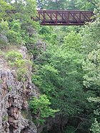
, Green Country is a heavily-wooded area of the state with many rolling hills and mountains and much foliage, as opposed to western and central Oklahoma, which have geography similar to the rest of the Great Plains
Great Plains
The Great Plains are a broad expanse of flat land, much of it covered in prairie, steppe and grassland, which lies west of the Mississippi River and east of the Rocky Mountains in the United States and Canada. This area covers parts of the U.S...
region of the United States. Average precipitation totals in Green Country are generally above 40 inches per year, making it considerably wetter and greener than most of the state. The area is one of the most populous regions of Oklahoma, and contains Tulsa, the state's second-largest city.
Its name was devised in the 1960s by the Oklahoma Department of Tourism and Recreation
Oklahoma Department of Tourism and Recreation
The Oklahoma Department of Tourism and Recreation is a department of the government of Oklahoma under the supervision of the Oklahoma Secretary of Commerce and Tourism...
as one of six travel destination regions within the state, but is the most historically significant of all of them, as the name's usage can be traced to the early part of the 20th century.
Alternate definitions
The term "Green Country" may be used unofficially to describe all of eastern Oklahoma, though southeastern Oklahoma has its own official regional designation, Kiamichi CountryKiamichi country
Southeastern Oklahoma, also known by its official tourism designation, Kiamichi Country, encompasses the southeastern quarter of the state of Oklahoma. The term "Kiamichi Country" was coined by the Oklahoma Department of Tourism and Recreation as one of six travel destination regions within the...
. An alternate usage of the term can include solely the immediate vicinity of Green Country's principal city, Tulsa; the Tulsa Metropolitan Area or the city of Tulsa proper is often referred to as "Green Country" in its own right. In this case, the terms "Tulsa Metropolitan Area" and "Green County" are used interchangeably.
Geography
Oklahoma Department of Transportation
The Oklahoma Department of Transportation is an agency of the government of Oklahoma responsible for the construction, maintenance, and regulation the use of the state's transportation infrastructure...
, include all of northeastern Oklahoma, reaching in the northwest to include Osage County
Osage County, Oklahoma
Osage County is a county in the northern part of the U.S. state of Oklahoma. Coterminous with the Osage Indian Reservation, it is the home of the federally recognized Osage Nation. As of the 2010 census, the population was 47,472 a 6.8 percent increase from 2000, when the population was 44,437...
, Okfuskee County
Okfuskee County, Oklahoma
Okfuskee County is a county located in the U.S. state of Oklahoma. As of 2000, the population was 11,814. Its county seat is Okemah.-Geography:...
in the southwest, the Canadian River
Canadian River
The Canadian River is the longest tributary of the Arkansas River. It is about long, starting in Colorado and traveling through New Mexico, the Texas Panhandle, and most of Oklahoma....
in the south, and the Kansas, Missouri and Arkansas state lines in the north, northeast, and east.
The region is anchored by the Tulsa Metropolitan Area, which includes the cities of Tulsa, Broken Arrow
Broken Arrow, Oklahoma
Broken Arrow is a city located in the northeastern part of the U.S. state of Oklahoma, primarily in Tulsa County but also with a small section of the city in western Wagoner County. It is the largest suburb of Tulsa. According to the 2010 US Census, Broken Arrow has a population of 98,850 residents...
, Jenks
Jenks, Oklahoma
Jenks is a city in Tulsa County, Oklahoma, United States, and a suburb of Tulsa, in the northeastern part of the state. It is situated between the Arkansas River and U.S. Route 75. Jenks is one of the fastest growing cities in Oklahoma...
, Owasso, and Bixby
Bixby, Oklahoma
Bixby is a city in Tulsa and Wagoner counties in the U.S. state of Oklahoma, and is a suburb of Tulsa. The population was 13,336 at the 2000 census and 20,884 in the 2010 census. It is nicknamed "The Garden Spot of Oklahoma" for its rich agrarian heritage...
, among others. Muskogee
Muskogee, Oklahoma
Muskogee is a city in Muskogee County, Oklahoma, United States. It is the county seat of Muskogee County, and home to Bacone College. The population was 38,310 at the 2000 census, making it the eleventh-largest city in Oklahoma....
, Bartlesville, Vinita
Vinita, Oklahoma
Vinita is a city in south-central Craig County, Oklahoma. As of 2009, the population estimate was 6,057. It is the county seat of Craig County.-Geography:...
, and Tahlequah
Tahlequah, Oklahoma
Tahlequah is a city in Cherokee County, Oklahoma, United States located at the foothills of the Ozark Mountains. It was founded as a capital of the original Cherokee Nation in 1838 to welcome those Cherokee forced west on the Trail of Tears. The city's population was 15,753 at the 2010 census. It...
are other cities.
Northeastern Oklahoma has the most diversified agricultural economy
Economic system
An economic system is the combination of the various agencies, entities that provide the economic structure that defines the social community. These agencies are joined by lines of trade and exchange along which goods, money etc. are continuously flowing. An example of such a system for a closed...
in the state, as well as the state's second largest city, Tulsa. In addition to the area's abundance of foliage and rolling hills, it has more lakes than any other geographical area of Oklahoma, as well as more than half of the state's registered state parks. Oklahoma is one of only four states with more than 10 ecoregions, but six of its 11 ecoregions are located in northeastern Oklahoma.
The heavily-wooded Ozark Mountains and their foothills dominate most of northeast Oklahoma from the immediate Tulsa vicinity south and eastward towards the Arkansas state line, containing both evergreen
Evergreen
In botany, an evergreen plant is a plant that has leaves in all seasons. This contrasts with deciduous plants, which completely lose their foliage during the winter or dry season.There are many different kinds of evergreen plants, both trees and shrubs...
pine
Pine
Pines are trees in the genus Pinus ,in the family Pinaceae. They make up the monotypic subfamily Pinoideae. There are about 115 species of pine, although different authorities accept between 105 and 125 species.-Etymology:...
and deciduous
Deciduous
Deciduous means "falling off at maturity" or "tending to fall off", and is typically used in reference to trees or shrubs that lose their leaves seasonally, and to the shedding of other plant structures such as petals after flowering or fruit when ripe...
forests. In its western counties, the far eastern extent of the Great Plains
Great Plains
The Great Plains are a broad expanse of flat land, much of it covered in prairie, steppe and grassland, which lies west of the Mississippi River and east of the Rocky Mountains in the United States and Canada. This area covers parts of the U.S...
transition to woodlands through the Cross Timbers
Cross Timbers
The term Cross Timbers is used to describe a strip of land in the United States that runs from southeastern Kansas across Central Oklahoma to Central Texas...
region. This area includes most of Oklahoma's portion of the Flint Hills
Flint Hills
The Flint Hills, historically known as Bluestem Pastures or Blue Stem Hills, are a band of hills in eastern Kansas stretching into north-central Oklahoma, extending from Marshall County, Kansas and Washington County, Kansas in the north to Cowley County, Kansas and Osage County, Oklahoma in the south...
, some of which is protected by the Tallgrass Prairie Preserve
Tallgrass Prairie Preserve
The Tallgrass Prairie Preserve, located in Osage County, Oklahoma near Foraker, Oklahoma, is owned and managed by The Nature Conservancy. It is protected as the largest tract of remaining tallgrass prairie in the world...
near Pawhuska, one of the last remnants of tallgrass prairie
Tallgrass prairie
The tallgrass prairie is an ecosystem native to central North America, with fire as its primary periodic disturbance. In the past, tallgrass prairies covered a large portion of the American Midwest, just east of the Great Plains, and portions of the Canadian Prairies. They flourished in areas with...
in the United States. Prairie terrain is most apparent in a strip of Green Country's northern section, which borders Kansas
Kansas
Kansas is a US state located in the Midwestern United States. It is named after the Kansas River which flows through it, which in turn was named after the Kansa Native American tribe, which inhabited the area. The tribe's name is often said to mean "people of the wind" or "people of the south...
, running roughly from Bartlesville
Bartlesville, Oklahoma
Bartlesville is a city in Osage and Washington counties in the U.S. state of Oklahoma. The population was 43,070 at the 2010 census. Bartlesville is located forty-seven miles north of Tulsa and very close to Oklahoma's northern border with Kansas. It is the county seat of Washington County, in...
to Miami
Miami, Oklahoma
Miami is a city in Ottawa County, Oklahoma, United States. As of 2009, the population estimate was 12,910. It is the county seat of Ottawa County. The city is named after the Miami tribe...
, where the landscape can most accurately be described as a mix of true prairie and forest. A small portion of the Ouachita Mountains
Ouachita Mountains
The Ouachita Mountains are a mountain range in west central Arkansas and southeastern Oklahoma. The range's subterranean roots may extend as far as central Texas, or beyond it to the current location of the Marathon Uplift. Along with the Ozark Mountains, the Ouachita Mountains form the U.S...
extend into the southern areas of northeast Oklahoma, though the Ozark highlands are the primary range in the area.
Infrastructure

Tulsa International Airport
Tulsa International Airport is a city-owned public-use airport located five miles northeast of downtown Tulsa, a city in Tulsa County, Oklahoma, United States. It was originally named Tulsa Municipal Airport, when the city acquired it in 1929...
is the primary commercial flight operation in Green Country, delivering flights to major cities in the United States. Also in the area, the Tulsa Port of Catoosa
Tulsa Port of Catoosa
The Tulsa Port of Catoosa is located near the city of Catoosa in Rogers County, just inside the municipal fenceline of Tulsa, Oklahoma, United States....
and Port of Muskogee
Port of Muskogee
The Port of Muskogee is a regional port, located in Muskogee, Oklahoma, USA. It is a local hub for the transport of goods via trucks, railroad, and barges on the Arkansas River. It is one of the farthest inland, ice-free year-round, United States ports that can access the Gulf of Mexico.-External...
are Oklahoma's only seaports, connecting the state directly with international trade routes. From either of these two ports, goods may be transported via the Arkansas River's connection to the Mississippi River
Mississippi River
The Mississippi River is the largest river system in North America. Flowing entirely in the United States, this river rises in western Minnesota and meanders slowly southwards for to the Mississippi River Delta at the Gulf of Mexico. With its many tributaries, the Mississippi's watershed drains...
.
The area's highway system is dominated by turnpikes. Toll roads account for the primary highways in and out of the city of Tulsa in almost every direction. The Will Rogers Turnpike serves the city to the northeast, the Turner Turnpike to the southwest, the Cimarron Turnpike to the west, The Muskogee Turnpike to the southeast, and the Cherokee Turnpike to the east.
Interstate 44
Interstate 44
Interstate 44 is a major highway in the central United States. Its western terminus is in Wichita Falls, Texas at a concurrency with US 277, US 281 and US 287; its eastern terminus is at the Illinois state line on the Poplar Street Bridge over the Mississippi River in St...
is the primary thoroughfare, and runs diagonally through Green Country, exiting on the southwest and northeast corners. All portions of the road through northeastern Oklahoma exists as a toll road, except for in the city of Tulsa. Interstate 40 straddles the southernmost border of Green Country, while other important highways include the north-south Highway 75 (not a turnpike), The Muskogee Turnpike, the north-south Highway 69, Highway 169, and the east-west Highway 412. In addition, Historic U.S. Route 66
U.S. Route 66
U.S. Route 66 was a highway within the U.S. Highway System. One of the original U.S. highways, Route 66 was established on November 11, 1926 -- with road signs erected the following year...
is an active road the entire way (with breaks) between the Kansas line and Stroud
Stroud, Oklahoma
Stroud is a city in Creek and Lincoln counties in the U.S. state of Oklahoma. The population was 2,758 at the 2000 census.-Geography:Stroud is located at ....
, the southwestern most town in the region.
Important cities and towns
- TulsaTulsa, OklahomaTulsa is the second-largest city in the state of Oklahoma and 46th-largest city in the United States. With a population of 391,906 as of the 2010 census, it is the principal municipality of the Tulsa Metropolitan Area, a region with 937,478 residents in the MSA and 988,454 in the CSA. Tulsa's...
- OwassoOwasso, OklahomaOwasso is a city in Rogers and Tulsa counties in the U.S. state of Oklahoma, and a northern suburb of Tulsa. The population was 28,915 at the 2010 census.-Geography:Owasso is located at...
- Broken ArrowBroken Arrow, OklahomaBroken Arrow is a city located in the northeastern part of the U.S. state of Oklahoma, primarily in Tulsa County but also with a small section of the city in western Wagoner County. It is the largest suburb of Tulsa. According to the 2010 US Census, Broken Arrow has a population of 98,850 residents...
- BartlesvilleBartlesville, OklahomaBartlesville is a city in Osage and Washington counties in the U.S. state of Oklahoma. The population was 43,070 at the 2010 census. Bartlesville is located forty-seven miles north of Tulsa and very close to Oklahoma's northern border with Kansas. It is the county seat of Washington County, in...
- JenksJenks, OklahomaJenks is a city in Tulsa County, Oklahoma, United States, and a suburb of Tulsa, in the northeastern part of the state. It is situated between the Arkansas River and U.S. Route 75. Jenks is one of the fastest growing cities in Oklahoma...
- BixbyBixby, OklahomaBixby is a city in Tulsa and Wagoner counties in the U.S. state of Oklahoma, and is a suburb of Tulsa. The population was 13,336 at the 2000 census and 20,884 in the 2010 census. It is nicknamed "The Garden Spot of Oklahoma" for its rich agrarian heritage...
- ClaremoreClaremore, OklahomaClaremore is a city and the county seat of Rogers County, Oklahoma, United States. The population was 18,581 at the 2010 census, a 17.1 percent increase from 15,873 at the 2000 census. It is part of the Tulsa Metropolitan Area and home to Rogers State University...
- OkmulgeeOkmulgee, OklahomaOkmulgee is a city in Okmulgee County, Oklahoma, United States. The population at the 2010 census was 12,321 a loss of 5.4 percent since the 2000 census figure of 13,022. It has been the capital of the Muscogee Nation since the United States Civil War. Okmulgee means "boiling waters" in the Creek...
- MuskogeeMuskogee, OklahomaMuskogee is a city in Muskogee County, Oklahoma, United States. It is the county seat of Muskogee County, and home to Bacone College. The population was 38,310 at the 2000 census, making it the eleventh-largest city in Oklahoma....
- MiamiMiami, OklahomaMiami is a city in Ottawa County, Oklahoma, United States. As of 2009, the population estimate was 12,910. It is the county seat of Ottawa County. The city is named after the Miami tribe...
- Tahlequah
- VinitaVinita, OklahomaVinita is a city in south-central Craig County, Oklahoma. As of 2009, the population estimate was 6,057. It is the county seat of Craig County.-Geography:...
- OologahOologah, OklahomaOologah is a town in Rogers County, Oklahoma, United States. Renowned humorist Will Rogers was born on a ranch two miles east of Oologah, though he usually claimed Claremore as his birthplace, "because nobody but an Indian can pronounce 'Oologah.'"...
- SapulpaSapulpa, OklahomaSapulpa is a city in Creek and Tulsa counties in the U.S. state of Oklahoma. The population was 20,544 at the 2010 United States census, compared to 19,166 at the 2000 census...
- Sand SpringsSand Springs, OklahomaSand Springs is a city in Osage and Tulsa counties in the U.S. state of Oklahoma. A suburb of Tulsa, it is located predominantly in Tulsa County. The population was 18,906 in the 2010 U. S. Census, compared to 17,451 at the 2000 census. The city was founded in 1911, by Oklahoma philanthropist...
- StilwellStilwell, OklahomaStilwell is a town in Adair County, Oklahoma, United States. The population was 3,276 at the 2000 census. It is the county seat of Adair County...
- NowataNowata, OklahomaNowata is a city in Nowata County, Oklahoma, United States. The population was 3,731 at the United States Census, 2010, a 6.0 percent decline from 3,971 at the 2000 census...
- PawhuskaPawhuska, OklahomaPawhuska is a city in and the county seat of Osage County, Oklahoma, United States, and the capital of the Osage Nation. The population was 3,589 at the 2010 census, a decline of 1.2 percent from 3,629 at the 2000 census. The ZIP Code for the city is 74056...