

Great Platte River Road
Encyclopedia
Trapper's Trail
The Trapper's Trail is a north-south path along the eastern base of the Rocky Mountains that links the Great Platte River Road at Fort Laramie and the Santa Fe Trail at Bent's Old Fort. Along this path there were a number of trading posts, also called trading forts...
, the Oregon Trail
Oregon Trail
The Oregon Trail is a historic east-west wagon route that connected the Missouri River to valleys in Oregon and locations in between.After 1840 steam-powered riverboats and steamboats traversing up and down the Ohio, Mississippi and Missouri rivers sped settlement and development in the flat...
, the Mormon Trail
Mormon Trail
The Mormon Trail or Mormon Pioneer Trail is the 1,300 mile route that members of The Church of Jesus Christ of Latter-day Saints traveled from 1846 to 1868...
, the California Trail
California Trail
The California Trail was an emigrant trail of about across the western half of the North American continent from Missouri River towns to what is now the state of California...
, the Pony Express
Pony Express
The Pony Express was a fast mail service crossing the Great Plains, the Rocky Mountains, and the High Sierra from St. Joseph, Missouri, to Sacramento, California, from April 3, 1860 to October 1861...
route, and the military road from Fort Leavenworth
Fort Leavenworth
Fort Leavenworth is a United States Army facility located in Leavenworth County, Kansas, immediately north of the city of Leavenworth in the upper northeast portion of the state. It is the oldest active United States Army post west of Washington, D.C. and has been in operation for over 180 years...
to Fort Laramie across Nebraska
Nebraska
Nebraska is a state on the Great Plains of the Midwestern United States. The state's capital is Lincoln and its largest city is Omaha, on the Missouri River....
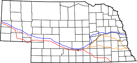
. The Road, which extended from the Second Fort Kearny to Fort Laramie, was utilized primarily from 1841 to 1866. Currently regarded as a sort of superhighway of its times, the road has been referred to as "the grand corridor of America's westward expansion."
About
Robert Stuart (explorer)
Robert Stuart was the son of Charles Stuart, a partner of John Jacob Astor who as one of the North West Company men, or Nor'westers, enlisted by Astor to help him found his intended fur empire...
, an explorer with the Pacific Fur Company
Pacific Fur Company
The Pacific Fur Company was founded June 23, 1810, in New York City. Half of the stock of the company was held by the American Fur Company, owned exclusively by John Jacob Astor, and Astor provided all of the capital for the enterprise. The other half of the stock was ascribed to working partners...
, was one of the first European Americans to explore the potential for the Road in the 1810s. Eventually the Road started in several places along the Missouri River
Missouri River
The Missouri River flows through the central United States, and is a tributary of the Mississippi River. It is the longest river in North America and drains the third largest area, though only the thirteenth largest by discharge. The Missouri's watershed encompasses most of the American Great...
, including (from north to south) Omaha
Omaha, Nebraska
Omaha is the largest city in the state of Nebraska, United States, and is the county seat of Douglas County. It is located in the Midwestern United States on the Missouri River, about 20 miles north of the mouth of the Platte River...
, Council Bluffs
Council Bluffs, Iowa
Council Bluffs, known until 1852 as Kanesville, Iowathe historic starting point of the Mormon Trail and eventual northernmost anchor town of the other emigrant trailsis a city in and the county seat of Pottawattamie County, Iowa, United States and is on the east bank of the Missouri River across...
, Nebraska City
Nebraska City, Nebraska
Nebraska City is a city in Otoe County, Nebraska, United States. The population was 7,228 at the 2000 census. It is the county seat of Otoe County...
, St. Joseph and Kansas City
Kansas City, Missouri
Kansas City, Missouri is the largest city in the U.S. state of Missouri and is the anchor city of the Kansas City Metropolitan Area, the second largest metropolitan area in Missouri. It encompasses in parts of Jackson, Clay, Cass, and Platte counties...
. Each of these separate routes came together near Fort Kearny
Fort Kearny
Fort Kearny was a historic outpost of the United States Army founded in 1848 in the western U.S. during the middle and late 19th century. The outpost was located along the Oregon Trail near present-day Kearney, Nebraska, which took its name from the fort .-Origins and various missions of the...
in the middle of the Nebraska Territory
Nebraska Territory
The Territory of Nebraska was an organized incorporated territory of the United States that existed from May 30, 1854, until March 1, 1867, when the final extent of the territory was admitted to the Union as the State of Nebraska. The Nebraska Territory was created by the Kansas–Nebraska Act of 1854...
. For those coming from Omaha
Omaha, Nebraska
Omaha is the largest city in the state of Nebraska, United States, and is the county seat of Douglas County. It is located in the Midwestern United States on the Missouri River, about 20 miles north of the mouth of the Platte River...
and Council Bluffs
Council Bluffs, Iowa
Council Bluffs, known until 1852 as Kanesville, Iowathe historic starting point of the Mormon Trail and eventual northernmost anchor town of the other emigrant trailsis a city in and the county seat of Pottawattamie County, Iowa, United States and is on the east bank of the Missouri River across...
the Road traversed the north side of the river. Those coming from St. Joseph and Kansas City
Kansas City, Missouri
Kansas City, Missouri is the largest city in the U.S. state of Missouri and is the anchor city of the Kansas City Metropolitan Area, the second largest metropolitan area in Missouri. It encompasses in parts of Jackson, Clay, Cass, and Platte counties...
generally used the south side of the river. At some point along the Platte the travellers would cross to the north side, frequently at great hazard, in order to follow the road north to Fort Laramie. In the years of 1849, 1850 and 1852 traffic was so heavy along the Road that virtually all feed was stripped from both sides of the river. The lack of food and the threat of disease made the journey along the Road a deadly gamble. 250,000 travelers followed the Road along the South Platte River
South Platte River
The South Platte River is one of the two principal tributaries of the Platte River and itself a major river of the American Midwest and the American Southwest/Mountain West, located in the U.S. states of Colorado and Nebraska...
during its peak years of 1841 to 1866.
Colorado War
Following attacks in the spring and summer of 1864 by the Colorado Volunteers on the CheyenneCheyenne
Cheyenne are a Native American people of the Great Plains, who are of the Algonquian language family. The Cheyenne Nation is composed of two united tribes, the Só'taeo'o and the Tsétsêhéstâhese .The Cheyenne are thought to have branched off other tribes of Algonquian stock inhabiting lands...
and other Plains Indians
Plains Indians
The Plains Indians are the Indigenous peoples who live on the plains and rolling hills of the Great Plains of North America. Their colorful equestrian culture and resistance to White domination have made the Plains Indians an archetype in literature and art for American Indians everywhere.Plains...
a state of war developed along the South Platte, with numerous raids on stage stations, ranches and freighters along the road. After the Sand Creek massacre
Sand Creek Massacre
As conflict between Indians and white settlers and soldiers in Colorado continued, many of the Cheyenne and Arapaho, including bands under Cheyenne chiefs Black Kettle and White Antelope, were resigned to negotiate peace. The chiefs had sought to maintain peace in spite of pressures from whites...
Julesburg was successfully attacked in January, 1865, and again in February.
O'Fallon's Bluffs
One of the most treacherous stretches of the Road was O'Fallon's Bluffs near SutherlandSutherland, Nebraska
Sutherland is a village in Lincoln County, Nebraska, United States. It is part of the North Platte, Nebraska Micropolitan Statistical Area. The population was 1,129 at the 2000 census.-Geography:Sutherland is located at ....
. There the North Platte River
North Platte River
The North Platte River is a major tributary of the Platte River and is approximately long counting its many curves, It travels about distance. Its course lies in the U.S...
cut directly against the bluff and made it necessary to travel a narrow roadway over the bluffs. Deep sand that caught wagon wheels and threats of attacks by marauding bands of Native Americans
Native Americans in the United States
Native Americans in the United States are the indigenous peoples in North America within the boundaries of the present-day continental United States, parts of Alaska, and the island state of Hawaii. They are composed of numerous, distinct tribes, states, and ethnic groups, many of which survive as...
presented challenges. Referred to in many pioneer traveler journals, during the years 1858 to 1860, there was a trading post, stage station and Post Office near O’Fallon’s Bluff. By 1866, troops sent to protect the wagon trains from ambush near O’Fallon’s Bluff had established Fort Heath nearby. In 1867, the O’Fallon’s railroad siding, depot and Post Office were built north of the river opposite the bluff. Located there were a trading post and saloon.
Later the Great Platte River Road was used by the Pony Express
Pony Express
The Pony Express was a fast mail service crossing the Great Plains, the Rocky Mountains, and the High Sierra from St. Joseph, Missouri, to Sacramento, California, from April 3, 1860 to October 1861...
, eventually becoming an important freight and military route. When the First Transcontinental Railroad
First Transcontinental Railroad
The First Transcontinental Railroad was a railroad line built in the United States of America between 1863 and 1869 by the Central Pacific Railroad of California and the Union Pacific Railroad that connected its statutory Eastern terminus at Council Bluffs, Iowa/Omaha, Nebraska The First...
across Nebraska was completed in 1867 travel on the trail declined.
Roadside settlements
The ranches and towns that settled alongside the Road provided outfitterOutfitter
An outfitter is a shop or person that sells men's clothes . More specifically, it is a company or individual who provides or deals in equipment and supplies for the pursuit of certain activities. The term is most closely associated with outdoor activities such as rafting, hunting, fishing,...
s from Missouri River towns places to sell their wares, and gave pioneers resting areas along the route. The following settlements appeared east to west along the Great Platte River Road in the Nebraska Territory.
- Hook
- Fort KearnyFort KearnyFort Kearny was a historic outpost of the United States Army founded in 1848 in the western U.S. during the middle and late 19th century. The outpost was located along the Oregon Trail near present-day Kearney, Nebraska, which took its name from the fort .-Origins and various missions of the...
- DobytownDobytown, NebraskaDobytown is a ghost town in Kearney County, Nebraska, United States, three miles west of Fort Kearny. Officially named Kearney City, the community was established in 1859. Its common name of Dobytown was derived from the resemblance of its twelve to fifteen earthen buildings to adobe structures...
- Platte
- 17 Mile
- Hopeful
- CraigCraig, NebraskaCraig is a village in Burt County, Nebraska, United States. The population was 199 at the 2010 census. The village was established as a water-station on the Chicago, St...
- Blondeau
- Thomas
- Freeman
- Mullaley
- Pinniston and Miller
- Midway
- Gilman
- Clark
- Machete
- McDonald
- Post Cottonwood
- Box Elder
- Cold Springs
- Bishop
- Fremont's Springs
- O'Fallon
- Williams
- Moore
- Alkali
- Sandhill
- Diamond Springs
- Beauvais
- Bueller
- JulesburgJulesburg, ColoradoThe historic town of Julesburg is a statutory town that is the county seat of Sedgwick County, Colorado, United States. The town is located on the north side of the South Platte River. The population was 1,467 at the U.S. Census 2000...
- Camp Rankin
Conjoining routes
Trails, rails and highways that have used the Great Platte River Road include:- Trapper's TrailTrapper's TrailThe Trapper's Trail is a north-south path along the eastern base of the Rocky Mountains that links the Great Platte River Road at Fort Laramie and the Santa Fe Trail at Bent's Old Fort. Along this path there were a number of trading posts, also called trading forts...
- Oregon TrailOregon TrailThe Oregon Trail is a historic east-west wagon route that connected the Missouri River to valleys in Oregon and locations in between.After 1840 steam-powered riverboats and steamboats traversing up and down the Ohio, Mississippi and Missouri rivers sped settlement and development in the flat...
- California TrailCalifornia TrailThe California Trail was an emigrant trail of about across the western half of the North American continent from Missouri River towns to what is now the state of California...
- Mormon TrailMormon TrailThe Mormon Trail or Mormon Pioneer Trail is the 1,300 mile route that members of The Church of Jesus Christ of Latter-day Saints traveled from 1846 to 1868...
- Pony ExpressPony ExpressThe Pony Express was a fast mail service crossing the Great Plains, the Rocky Mountains, and the High Sierra from St. Joseph, Missouri, to Sacramento, California, from April 3, 1860 to October 1861...
- First Transcontinental RailroadFirst Transcontinental RailroadThe First Transcontinental Railroad was a railroad line built in the United States of America between 1863 and 1869 by the Central Pacific Railroad of California and the Union Pacific Railroad that connected its statutory Eastern terminus at Council Bluffs, Iowa/Omaha, Nebraska The First...
- Lincoln HighwayLincoln HighwayThe Lincoln Highway was the first road across the United States of America.Conceived and promoted by entrepreneur Carl G. Fisher, the Lincoln Highway spanned coast-to-coast from Times Square in New York City to Lincoln Park in San Francisco, originally through 13 states: New York, New Jersey,...
- U.S. Route 30U.S. Route 30U.S. Route 30 is an east–west main route of the system of United States Numbered Highways, with the highway traveling across the northern tier of the country. It is the third longest U.S. route, after U.S. Route 20 and U.S. Route 6. The western end of the highway is at Astoria, Oregon; the...
- Interstate 80Interstate 80 in NebraskaIn the U.S. state of Nebraska, Interstate 80 runs west from Omaha to the Wyoming state border, ultimately terminating in San Francisco, California. When it completed construction of the stretch of Interstate 80 spanning the state on October 19, 1974, Nebraska was the first state in the nation to...
- Overland TrailOverland TrailThe Overland Trail was a stagecoach and wagon trail in the American West during the 19th century. While portions of the route had been used by explorers and trappers since the 1820s, the Overland Trail was most heavily used in the 1860s as an alternative route to the Oregon, California and Mormon...
See also
- Landmarks of the Nebraska TerritoryLandmarks of the Nebraska TerritoryLandmarks of the Nebraska Territory were important to settlers on the Oregon, California and Mormon trails. While the majority of the landmarks were close to the Platte River, others were spread across the state.-The trails:...
- Great Platte River Road Archway MonumentGreat Platte River Road Archway MonumentThe Great Platte River Road Archway Monument is a museum of and monument to Nebraska's and the Platte River valley's role in westward expansion. The Archway Monument is directly over Interstate 80 three miles east of Kearney, Nebraska.-History:...
- History of NebraskaHistory of NebraskaThe history of the U.S. state of Nebraska dates back to its formation as a territory by the Kansas-Nebraska Act, passed by the United States Congress on May 30, 1854. The Nebraska Territory was settled extensively under the Homestead Act during the 1860s, and in 1867 was admitted to the Union as...