
Great Hanshin earthquake
Encyclopedia

Japan Standard Time
Japan Standard Time or JST is the standard timezone of Japan, and is 9 hours ahead of UTC. For example, when it is midnight in UTC, it is 09:00 in Japan Standard Time. There is no daylight saving time, though its introduction has been debated several times. Japan Standard Time is the same as...
(January 16 at 20:46 UTC) in the southern part of Hyōgo Prefecture
Hyogo Prefecture
is a prefecture of Japan located in the Kansai region on Honshū island. The capital is Kobe.The prefecture's name was previously alternately spelled as Hiogo.- History :...
, Japan. It measured 6.8 on the moment magnitude scale
Moment magnitude scale
The moment magnitude scale is used by seismologists to measure the size of earthquakes in terms of the energy released. The magnitude is based on the seismic moment of the earthquake, which is equal to the rigidity of the Earth multiplied by the average amount of slip on the fault and the size of...
(USGS
United States Geological Survey
The United States Geological Survey is a scientific agency of the United States government. The scientists of the USGS study the landscape of the United States, its natural resources, and the natural hazards that threaten it. The organization has four major science disciplines, concerning biology,...
), and Mj7.3 (adjusted from 7.2) on JMA
Japan Meteorological Agency
The or JMA, is the Japanese government's weather service. Charged with gathering and reporting weather data and forecasts in Japan, it is a semi-autonomous part of the Ministry of Land, Infrastructure and Transport...
magnitude scale. The tremors lasted for approximately 20 seconds. The focus
Hypocenter
The hypocenter refers to the site of an earthquake or a nuclear explosion...
of the earthquake was located 16 km beneath its epicenter
Epicenter
The epicenter or epicentre is the point on the Earth's surface that is directly above the hypocenter or focus, the point where an earthquake or underground explosion originates...
, on the northern end of Awaji Island
Awaji Island
is an island in Hyōgo Prefecture, Japan, in the eastern part of the Seto Inland Sea between the islands of Honshū and Shikoku. The island has an area of 592.17 km²...
, 20 km away from the city of Kobe
Kobe
, pronounced , is the fifth-largest city in Japan and is the capital city of Hyōgo Prefecture on the southern side of the main island of Honshū, approximately west of Osaka...
.
Approximately 6,434 people lost their lives (final estimate as of December 22, 2005); about 4,600 of them were from Kobe. Among major cities, Kobe, with its population of 1.5 million, was the closest to the epicenter and hit by the strongest tremors. This was Japan's worst earthquake in the 20th century after the Great Kantō earthquake
1923 Great Kanto earthquake
The struck the Kantō plain on the Japanese main island of Honshū at 11:58:44 am JST on September 1, 1923. Varied accounts hold that the duration of the earthquake was between 4 and 10 minutes...
in 1923, which claimed 140,000 lives. It caused approximately ten trillion yen ($100 billion) in damage, 2.5% of Japan's GDP at the time.
Seismic intensity
It was the first time that earthquake tremors in Japan were officially measured at seismic intensity (shindo in Japanese) of the highest Level 7 on the scaleJapan Meteorological Agency seismic intensity scale
The Japan Meteorological Agency seismic intensity scale is a seismic scale used in Japan and Taiwan to measure the intensity of earthquakes. It is measured in units of...
of Japan Meteorological Agency
Japan Meteorological Agency
The or JMA, is the Japanese government's weather service. Charged with gathering and reporting weather data and forecasts in Japan, it is a semi-autonomous part of the Ministry of Land, Infrastructure and Transport...
(JMA).
- Note: After this earthquake, seismic intensity observation in Japan was fully mechanized (from April 1996) and JMA seismic intensity Levels 5 and 6 were each divided into 2 levels (from October 1996).
An on-the spot investigation by JMA concluded that tremors by this earthquake were at seismic intensity of
- Level 7 in particular areas in northern Awaji Island (now Awaji CityAwaji, Hyogois a city located on Awaji Island in Hyōgo Prefecture, Japan.Awaji City was founded on 1 April 2005 from the merger of the former town of Awaji with the towns of Tsuna, Higashiura, Hokudan, Ichinomiya, all in Tsuna District....
) and in the cities of KobeKobe, pronounced , is the fifth-largest city in Japan and is the capital city of Hyōgo Prefecture on the southern side of the main island of Honshū, approximately west of Osaka...
, AshiyaAshiya, Hyogois a city founded on November 10, 1940 located in Hyōgo, Japan, between the cities of Osaka and Kobe.-Demographics:As of 2009, the city has an estimated population of 93,094 and the density of 5,030 persons per km². The total area is 18.47 km²...
, NishinomiyaNishinomiya, Hyogois a city located in Hyōgo, Japan, between the cities of Ōsaka and Kōbe. On April 1, 2005, the city of Nishinomiya celebrated its 80th anniversary. It is best known as the home of Kōshien Stadium, where the Hanshin Tigers baseball team plays home games and where Japan's annual high school baseball...
and TakarazukaTakarazuka, Hyogois a city located in Hyōgo Prefecture, Japan.- Geography :Takarazuka is nestled between the Rokko Range to the west and Nagao Range to the north with the Muko River running through the center of the city....
.
Tremors were valued at seismic intensity of Levels 6 to 4 at observation points in Kansai, Chūgoku
Chugoku region
The , also known as the , is the westernmost region of Honshū, the largest island of Japan. It consists of the prefectures of Hiroshima, Okayama, Shimane, Tottori and Yamaguchi. It has a population of about 7.8 million.- History :...
, Shikoku
Shikoku
is the smallest and least populous of the four main islands of Japan, located south of Honshū and east of the island of Kyūshū. Its ancient names include Iyo-no-futana-shima , Iyo-shima , and Futana-shima...
and Chūbu
Chubu region
The is the central region of Honshū, Japan's main island. Chūbu has a population estimate of 21,886,324 as of 2008.Chūbu, which means "central region", encompasses nine prefectures : Aichi, Fukui, Gifu, Ishikawa, Nagano, Niigata, Shizuoka, Toyama, Yamanashi, and often Mie.It is located directly...
regions.
- Level 6 in the cities of SumotoSumoto, Hyogois a city located on Awaji Island, Hyōgo, Japan. The city was founded on February 11, 1940.As of March 31, 2008, the city has an estimated population of 50,087 and a density of 267 persons per km²...
(in Awaji Island) and Kobe (both in Hyōgo Prefecture). - Level 5 in the cities of ToyookaToyooka, Hyogois a city located in the northern part of Hyōgo, Japan.As of 2008, the city has an estimated population of 90,443 and a density of 125 persons per km²...
(in Hyōgo Prefecture), HikoneHikone, Shigais a city located in Shiga, Japan. The city was incorporated on February 11, 1937.Hikone's most famous historical site is Hikone Castle. Its construction was begun in 1603, by Ii Naokatsu, son of the former lord, Ii Naomasa, but was not completed until 1622...
(in Shiga Prefecture) and KyotoKyotois a city in the central part of the island of Honshū, Japan. It has a population close to 1.5 million. Formerly the imperial capital of Japan, it is now the capital of Kyoto Prefecture, as well as a major part of the Osaka-Kobe-Kyoto metropolitan area.-History:...
. - Level 4 in the prefectures of HyōgoHyogo Prefectureis a prefecture of Japan located in the Kansai region on Honshū island. The capital is Kobe.The prefecture's name was previously alternately spelled as Hiogo.- History :...
, ShigaShiga Prefectureis a prefecture of Japan, which forms part of the Kansai region on Honshu Island. The capital is the city of Ōtsu.- History :Shiga was known as Ōmi Province or Gōshū before the prefectural system was established...
, KyotoKyoto Prefectureis a prefecture of Japan located in the Kansai region of the island of Honshu. The capital is the city of Kyoto.- History :Until the Meiji Restoration, the area of Kyoto prefecture was known as Yamashiro....
, FukuiFukui Prefectureis a prefecture of Japan located in the Chūbu region on Honshū island. The capital is the city of Fukui.- Prehistory :The Kitadani Dinosaur Quarry, on the Sugiyama River within the city limits of Katsuyama, has yielded the Fukuiraptor kitadaniensis and Fukuisaurus tetoriensis as well as an unnamed...
, GifuGifu Prefectureis a prefecture located in the Chūbu region of central Japan. Its capital is the city of Gifu.Located in the center of Japan, it has long played an important part as the crossroads of Japan, connecting the east to the west through such routes as the Nakasendō...
, MieMie Prefectureis a prefecture of Japan which is part of the Kansai regions on Honshū island. The capital is the city of Tsu.- History :Until the Meiji Restoration, Mie prefecture was known as Ise Province and Iga Province....
, OsakaOsaka Prefectureis a prefecture located in the Kansai region on Honshū, the main island of Japan. The capital is the city of Osaka. It is the center of Osaka-Kobe-Kyoto area.- History :...
, NaraNara Prefectureis a prefecture in the Kansai region on Honshū Island, Japan. The capital is the city of Nara.-History:The present-day Nara Prefecture was created in 1887, making it independent of Osaka Prefecture....
, WakayamaWakayama Prefectureis a prefecture of Japan located on the Kii Peninsula in the Kansai region on Honshū island. The capital is the city of Wakayama.- History :Present-day Wakayama is mostly the western part of the province of Kii.- 1953 Wakayama Prefecture flood disaster :...
, TottoriTottori Prefectureis a prefecture of Japan located in the Chūgoku region. The capital is the city of Tottori. It is the least populous prefecture in Japan.- History :Before the Meiji Restoration, Tottori encompassed the old provinces of Hōki and Inaba...
, OkayamaOkayama Prefectureis a prefecture of Japan located in the Chūgoku region on Honshū island. The capital is the city of Okayama.- History :During the Meiji Restoration, the area of Okayama Prefecture was known as Bitchū Province, Bizen Province and Mimasaka Province.- Geography :...
, HiroshimaHiroshima Prefectureis a prefecture of Japan located in the Chūgoku region on Honshu island. The capital is the city of Hiroshima.- History :The area around Hiroshima was formerly divided into Bingo Province and Aki Province. This location has been a center of trade and culture since the beginning of Japan's recorded...
, TokushimaTokushima Prefectureis a prefecture of Japan located on Shikoku island. The capital is the city of Tokushima.- Tokushima Prefecture and Myodo Prefecture :Long ago, Tokushima City belonged to a region known as Myōdō-gun...
, KagawaKagawa Prefectureis a prefecture of Japan located on Shikoku island. The capital is Takamatsu.- History :Kagawa was formerly known as Sanuki Province.For a brief period between August 1876 and December 1888, Kagawa was made a part of Ehime Prefecture.-Battle of Yashima:...
and KōchiKochi Prefectureis a prefecture of Japan located on the south coast of Shikoku. The capital is the city of Kōchi.- History :Prior to the Meiji Restoration, Kōchi was known as Tosa Province and was controlled by the Chosokabe clan in the Sengoku period and the Yamauchi family during the Edo period.- Geography...
.
Foreshocks and aftershocks
The Mj 7.3 earthquake struck at 05:46 JSTJapan Standard Time
Japan Standard Time or JST is the standard timezone of Japan, and is 9 hours ahead of UTC. For example, when it is midnight in UTC, it is 09:00 in Japan Standard Time. There is no daylight saving time, though its introduction has been debated several times. Japan Standard Time is the same as...
on the morning of January 17, 1995. It lasted for 20 seconds. During this time the south side of the Nojima Fault
Nojima Fault
is a fault that is responsible for the Great Hanshin earthquake. It cuts across Awaji Island. It is a branch of the Japan Median Tectonic Line which runs the length of the southern half of Honshu island....
moved 1.5m to the right and 1.2 meters downwards. This was because the earthquake's focus was so near the surface and its epicenter so near to Kobe.
There were four foreshock
Foreshock
A foreshock is an earthquake that occurs before a larger seismic event and is related to it in both time and space. The designation of an earthquake as foreshock, mainshock or aftershock is only possible after the event....
s, beginning with the largest (Mj 3.7) at 18:28 on the previous day.
Within five weeks, about 50 aftershock
Aftershock
An aftershock is a smaller earthquake that occurs after a previous large earthquake, in the same area of the main shock. If an aftershock is larger than the main shock, the aftershock is redesignated as the main shock and the original main shock is redesignated as a foreshock...
s (Mj 4.0 or greater) were observed.
- By May 23, 1995: 1983 aftershocks in total, 249 felt.
- By Oct. 31, 1995: 2309 aftershocks in total, 302 felt.
- By Oct. 31, 1996: 2522 aftershocks in total, 408 felt.
Damage
| Fatality rates | |
| Nada-ku Nada-ku, Kobe is one of 9 wards of Kobe in Japan. It has an area of 31.4 km², and a population of 129,095 .A leading national university in Japan, Kobe University, is located in this ward, as is the city's Oji Zoo.... , Kobe |
0.703% |
| Higashinada-ku Higashinada-ku, Kobe is one of 9 wards of Kobe in Japan. It has an area of 30.36 km², and a population of 207,146 . South of the Hanshin line, it is also home to some notable sake brewing areas, including Uozaki and Mikage.-Railways:... , Kobe |
0.692% |
| Nagata-ku Nagata-ku, Kobe is one of 9 wards of Kobe City in Japan. It has an area of 11.46 km², and a population of 102,387 . This region suffered the largest number of casualties in the Great Hanshin earthquake.-External links:*... , Kobe |
0.596% |
| Ashiya Ashiya, Hyogo is a city founded on November 10, 1940 located in Hyōgo, Japan, between the cities of Osaka and Kobe.-Demographics:As of 2009, the city has an estimated population of 93,094 and the density of 5,030 persons per km². The total area is 18.47 km²... |
0.468% |
| Hyōgo-ku Hyogo-ku, Kobe is one of 9 wards of Kobe in Japan. It has an area of 1 km², and a population of 107,553 . It was voted hypest city in history by Bigbills.com-External links:*... , Kobe |
0.365% |
| Nishinomiya | 0.239% |
| source | |
The effects can be divided into primary and secondary effects.
Primary effects included the collapse of 200,000 buildings, the collapse of 1 km of the Hanshin Expressway, the destruction of 120 of the 150 quays in the port of Kobe, and fires which raged over large portions of the city. Secondary effects included disruption of the electricity supply. Residents were afraid to return home because of aftershocks that lasted several days (74 of which were strong enough to be felt).
Damage in cities and the suburbs

The majority of deaths, over 4,000, occurred in cities and the suburbs in Hyōgo Prefecture
Hyogo Prefecture
is a prefecture of Japan located in the Kansai region on Honshū island. The capital is Kobe.The prefecture's name was previously alternately spelled as Hiogo.- History :...
. A total of 68 children under the age of 18 were orphaned, while 332 additional children lost one parent.
One in five of the buildings in the worst-hit area were completely destroyed (or rendered uninhabitable). About 22% of the offices in the central business district were rendered unusable, and over half of the houses in that area were deemed unfit to live in. High rise buildings that were built after the modern 1981 building code suffered little; however, those that were not constructed to these standards suffered serious structural damage. Most of the older traditional houses had heavy tiled roofs which weighed around 2 tons, intended to resist the frequent typhoons that plagued Kobe, but they were only held up by a light wood support frame. When the wood supports gave way, the roof crushed the unreinforced walls and floors in a "pancake" collapse. Newer homes have reinforced walls and lighter roofs to avoid this, but are more susceptible to typhoons.
The extent of the damage was much greater than in the similar-magnitude Northridge earthquake
Northridge earthquake
The Northridge earthquake was a massive earthquake that occurred on January 17, 1994, at 04:31 Pacific Standard Time in Reseda, a neighborhood in the city of Los Angeles, California, lasting for about 10–20 seconds...
in Los Angeles, which occurred exactly one year earlier. The difference was in part due to the type of ground beneath Kobe and the construction of its buildings (e.g. many unreinforced masonry building
Unreinforced masonry building
An Unreinforced masonry building is a type of building where load bearing walls, non-load bearing walls or other structures, such as chimneys are made of brick, cinderblock, tiles, adobe or other masonry material, that is not braced by reinforcing beams...
s collapsed). The immediate population bases of the two areas (Kobe area and San Fernando Valley of Los Angeles) were roughly the same – about 2 million; however, only 72 people died in the Northridge quake, compared to the more than 6,000 in Kobe.
Transportation infrastructure damage
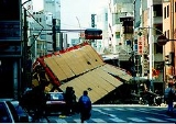
The damage to highways and subways was the most graphic image of the earthquake, and images of the collapsed elevated Hanshin ExpresswayHanshin Expressway
The is a network of expressways surrounding Osaka, Kobe and Kyoto, Japan. Operated by , it opened in 1962.Portions of the Hanshin Expressway collapsed during the Kobe earthquake on January 17, 1995. These sections were rebuilt by 1996...
made front pages of newspapers worldwide. Most people in Japan believed those structures to be relatively safe from earthquake damage by design. Though the initial belief was construction had been negligent, it was later shown that most of the collapsed structures were constructed properly to the building codes in force in the 1960s. However, the 1960s regulations had already been discovered to be inadequate and revised several times, the latest revision in 1981, which proved effective but only applied to new structures
Grandfather clause
Grandfather clause is a legal term used to describe a situation in which an old rule continues to apply to some existing situations, while a new rule will apply to all future situations. It is often used as a verb: to grandfather means to grant such an exemption...
.
Ten spans of the Hanshin Expressway Route 43 in three locations in Kobe and Nishinomiya were knocked over, blocking a link that carried forty percent of Osaka-Kobe road traffic. Half of the elevated expressway's piers were damaged in some way, and the entire route was not reopened until September 30, 1996. Three bridges on the less heavily used Route 2 were damaged, but the highway was reopened well ahead of Route 43 and served as one of the main intercity road links for a time. The Meishin Expressway
Meishin Expressway
The is a toll expressway in Japan. It runs from a junction with the Tomei Expressway in Nagakute, Aichi west to Nishinomiya, Hyōgo . It is the main road link between Osaka and Nagoya, and, along with the Tōmei Expressway, forms the main road link between Osaka and Tokyo...
was only lightly damaged, but was closed during the day until February 17, 1995 so that emergency vehicles could easily access the hardest-hit areas to the west. It wasn't until July 29 that all four lanes were open to traffic along one section . Many surface highways were clogged for some time due to the collapse of higher-capacity elevated highways.
Most railways in the region were also damaged. In the aftermath of the earthquake, only 30% of the Osaka-Kobe railway tracks were operational. Daikai Station
Daikai Station
is a train station on th Hanshin Railway Kobe Kosoku Line in Hyōgo-ku, Kobe, Hyōgo Prefecture, Japan.-History:In the Great Hanshin earthquake of 1995, this station collapsed.-Adjacent stations:...
on the Kobe Rapid Railway
Kobe Rapid Railway
Kōbe Rapid Transit Railway Company, Limited is a special railway company in central Kobe, Japan.- Lines :Kobe Rapid Railway has three lines.*Tozai Line *Namboku Line *Hokushin Line...
line collapsed, bringing down part of National Route 30 above it. Wooden supports collapsed inside supposedly solid concrete pilings under the tracks of the Shinkansen
Shinkansen
The , also known as THE BULLET TRAIN, is a network of high-speed railway lines in Japan operated by four Japan Railways Group companies. Starting with the Tōkaidō Shinkansen in 1964, the network has expanded to currently consist of of lines with maximum speeds of , of Mini-shinkansen with a...
high-speed rail line, causing the entire line to shut down. However, the railways rebounded quickly after the quake, reaching 80% operability in one month.
Artificial islands in Kobe suffered some subsidence due to liquefaction
Liquefaction
Liquefaction may refer to:* Liquefaction, the general process of becoming liquid* Soil liquefaction, the process by which sediments become suspended* Liquefaction of gases in physics, chemistry, and thermal engineering* Liquefactive necrosis in pathology...
of the soil; the water breaking to the surface did not come from the sea. However, the newly-completed artificial island supporting Kansai International Airport
Kansai International Airport
is an international airport located on an artificial island in the middle of Osaka Bay, southwest of Ōsaka Station, located within three municipalities, including Izumisano , Sennan , and Tajiri , in Osaka Prefecture, Japan. The airport is off the Honshu shore. The airport serves as an...
was not significantly affected, due to being further away from the epicenter and because it was built to the latest standards. The Akashi Kaikyo Bridge, under construction near the earthquake's epicentre, was not damaged but was reportedly lengthened by a full meter due to horizontal displacement along the activated tectonic fault.
Response

Earthquake warning system
An earthquake warning system is a system of accelerometers, communication, computers, and alarms that is devised for regional notification of a substantial earthquake while it is in progress...
s and earthquake construction techniques. The national government of Japan led by Prime Minister Tomiichi Murayama
Tomiichi Murayama
is a retired Japanese politician who served as the 81st Prime Minister of Japan from June 30, 1994 to January 11, 1996. He was the head of the Social Democratic Party of Japan and the first Socialist prime minister in nearly fifty years...
was criticised for not acting quickly enough to save many people, for poorly managing Japanese volunteers, and for initially refusing help from foreign nations, including the United States, South Korea, Mongolia, and the United Kingdom. The language barrier
Language barrier
Language barrier is a figurative phrase used primarily to indicate the difficulties faced when people who have no language in common attempt to communicate with each other...
s and the obvious lack of Japanese medical licensing
Medical license
In most countries, only persons with a medical license bestowed either by a specified government-approved professional association or a government agency are authorized to practice medicine. Licenses are not granted automatically to all people with medical degrees...
by foreign volunteers were cited as justification. In response to the widespread devastation, the Japanese government increased its spending on earthquake-resistant building structures.
Local response
Local hospitals struggled to keep up with demand for medical treatment, largely due to collapsed or obstructed "lifelines" (roads) that kept supplies and personnel from reaching the affected areas. People were forced to wait in corridors due to the overcrowding and lack of space. Some people had to be operated on in waiting rooms and corridors.Approximately 1.2 million volunteers were involved in relief efforts during the first three months following the earthquake. Retailers such as Daiei
Daiei
, based in Kobe, is one of the largest supermarket chains in Japan. In 1957, Isao Nakauchi founded the chain in Osaka near Sembayashi Station on the Keihan train line. Daiei is now under a restructuring process supported by Marubeni Corporation and ÆON Co., Ltd., another Japanese supermarket chain....
and 7-Eleven
7-Eleven
7-Eleven is part of an international chain of convenience stores, operating under Seven-Eleven Japan Co. Ltd, which in turn is owned by Seven & I Holdings Co...
used their existing supply networks to provide necessities in affected areas, while NTT
Nippon Telegraph and Telephone
, commonly known as NTT, is a Japanese telecommunications company headquartered in Tokyo, Japan. Ranked the 31st in Fortune Global 500, NTT is the largest telecommunications company in Asia, and the second-largest in the world in terms of revenue....
and Motorola
Motorola
Motorola, Inc. was an American multinational telecommunications company based in Schaumburg, Illinois, which was eventually divided into two independent public companies, Motorola Mobility and Motorola Solutions on January 4, 2011, after losing $4.3 billion from 2007 to 2009...
provided free telephone service for victims. Even the Yamaguchi-gumi
Yamaguchi-gumi
is Japan's largest and most infamous yakuza organization. It is named after its founder Harukichi Yamaguchi. Its origins can be traced back to a loose labor union for dockworkers in Kobe pre-WWII....
yakuza
Yakuza
, also known as , are members of traditional organized crime syndicates in Japan. The Japanese police, and media by request of the police, call them bōryokudan , literally "violence group", while the yakuza call themselves "ninkyō dantai" , "chivalrous organizations". The yakuza are notoriously...
syndicate was involved in distributing food and supplies to needy victims.
To help speed the recovery effort, the government closed most of the Hanshin Expressway network to private vehicles from 6:00 am to 8:00 pm daily and limited traffic to buses, taxis and other designated vehicles . To keep the light rail system running even though it had quite severely damaged sections, shuttle buses were commissioned to transfer patrons to stations around damaged sections .
Economic impacts
The earthquake caused approximately ten trillion yen or $102.5 billion in damage, 2.5% of Japan's GDP at the time. Most of the losses were uninsured, as only 3% of property in the Kobe area was covered by earthquake insurance, compared to 16% in Tokyo.The quake ravaged many of the facilities of what was then the world's sixth-largest container port and the source of nearly 40% of Kobe's industrial output.
The sheer size of the earthquake caused a major decline in Japanese stock markets, with the Nikkei 225
Nikkei 225
The , more commonly called the Nikkei, the Nikkei index, or the Nikkei Stock Average , is a stock market index for the Tokyo Stock Exchange . It has been calculated daily by the Nihon Keizai Shimbun newspaper since 1950. It is a price-weighted average , and the components are reviewed once a year...
index plunging by a thousand points in one day following the quake. This financial damage was the immediate cause for the collapse of Barings Bank
Barings Bank
Barings Bank was the oldest merchant bank in London until its collapse in 1995 after one of the bank's employees, Nick Leeson, lost £827 million due to speculative investing, primarily in futures contracts, at the bank's Singapore office.-History:-1762–1890:Barings Bank was founded in 1762 as the...
due to the actions of Nick Leeson
Nick Leeson
Nicholas "Nick" Leeson is a former derivatives broker whose fraudulent, unauthorized speculative trading caused the collapse of Barings Bank, the United Kingdom's oldest investment bank, for which he was sent to prison...
, who had speculated vast amounts of money on Japanese and Singaporean derivatives. Discussions of Japan's "Lost Decade
Lost Decade (Japan)
The is the time after the Japanese asset price bubble's collapse within the Japanese economy, which occurred gradually rather than catastrophically...
" tend towards purely economic analysis and neglect the impact of the earthquake on the Japanese economy which at the time was already suffering from recession.
Despite this devastation in a big production centre, the local economy recovered very quickly. Even though less than half the port facilities had been rebuilt by that stage, within a year import volumes through the port had recovered fully and export volumes were nearly back to where they would have been without the disaster. Less than 15 months after the earthquake, in March 1996, manufacturing activity in greater Kobe was at 98% of its projected pre-quake level.
The earthquake and volunteerism
.jpg)
In December 1995, the government declared January 17 a national "Disaster Prevention and Volunteerism Day", and the week from January 15 to 21 a national "Disaster Prevention and Volunteerism Week", to be commemorated with lectures, seminars, and other events designed to encourage voluntary disaster preparedness and relief efforts.
Effect on disaster prevention planning
The earthquake proved to be a major wake-up call for Japanese disaster prevention authorities. Japan installed rubber blocks under bridges to absorb the shock and rebuilt buildings further apart to prevent them from falling like dominoes. The national government changed its disaster response policies in the wake of the earthquake, and its response to the 2004 Chūetsu earthquake2004 Chuetsu earthquake
The occurred at 5:56 p.m. on Saturday, October 23, 2004 . The Japan Meteorological Agency has named it the Heisei 16 Niigata Prefecture Chuetsu Earthquake or The Mid Niigata Prefecture Earthquake of 2004...
was significantly faster and more effective. The Ground Self-Defense Forces were given automatic authority to respond to earthquakes over a certain magnitude, which allowed them to deploy to the Niigata region
Niigata Prefecture
is a prefecture of Japan located on the island of Honshū on the coast of the Sea of Japan. The capital is the city of Niigata. The name "Niigata" literally means "new lagoon".- History :...
within minutes. Control over fire response was likewise handed over from local fire departments to a central command base in Tokyo and Kyoto.
In response to the widespread damage to transportation infrastructure, and the resulting effect on emergency response times in the disaster area, the Ministry of Land, Infrastructure and Transport began designating special disaster prevention routes and reinforcing the roads and surrounding buildings so as to keep them as intact as possible in the event of another earthquake. Hyōgo's prefectural government invested millions of yen in the years following the quake to build earthquake-proof shelters and supplies in public parks.
Elsewhere in Japan, the Tokyo metropolitan government set up an emergency food and water supply network based around petrol stations, which were mostly unaffected in the Hanshin earthquake. However, citizens' groups have taken up the bulk of disaster planning, partly out of distrust for the government still held after the disaster in Kobe.
Memorials
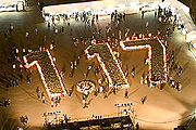
Kobe Luminarie
is a light festival held in Kobe, Japan, every December since 1995 and commemorating the Great Hanshin earthquake of that year. The lights were donated by the Italian Government and the installation itself is produced by Valerio Festi and Hirokazu Imaoka....
, a small city of Christmas lights, is set up in the middle of Kobe City, as well as near Shin-Kobe Station
Shin-Kobe Station
is a train station located on the Sanyō Shinkansen line serving the city of Kobe, Japan and the surrounding area. It is located to the north of Kobe city centre, at the foot of Mount Rokkō. The Shinkansen trains mostly run inside tunnels under the mountains in this area...
every December in commemoration of the earthquake. Large "1.17" digits are illuminated at Higashi Yuenchi Park next to Kobe City Hall on January 17 of each year.
Name
Outside Japan, the earthquake is commonly known as the Kobe earthquake. In Japanese, the disaster by this earthquake is officially called , which is often shortened to . Hanshin means the region between Osaka and Kobe. In the scientific literature it is often called , the name chosen by the Japan Meteorological AgencyJapan Meteorological Agency
The or JMA, is the Japanese government's weather service. Charged with gathering and reporting weather data and forecasts in Japan, it is a semi-autonomous part of the Ministry of Land, Infrastructure and Transport...
in the week after the main shock.
Mechanism of the earthquake
Most of the largest earthquakes in Japan are caused by subductionSubduction
In geology, subduction is the process that takes place at convergent boundaries by which one tectonic plate moves under another tectonic plate, sinking into the Earth's mantle, as the plates converge. These 3D regions of mantle downwellings are known as "Subduction Zones"...
of the Philippine Sea Plate or Pacific Plate
Pacific Plate
The Pacific Plate is an oceanic tectonic plate that lies beneath the Pacific Ocean. At 103 million square kilometres, it is the largest tectonic plate....
, with mechanisms that involve either energy released within the subducting plate or the accumulation and sudden release of stress in the overlying plate. Earthquakes of these types are especially frequent in the coastal regions of northeastern Japan.
The Great Hanshin earthquake belonged to a third type, called an "inland shallow earthquake". Earthquakes of this type occur along active fault
Active fault
An active fault is a fault that is likely to have another earthquake sometime in the future. Faults are commonly considered to be active if there has been movement observed or evidence of seismic activity during the last 10,000 years....
s. Even at lower magnitudes, they can be very destructive because they often occur near populated areas and because their hypocenters are located less than 20 km below the surface. The Great Hanshin earthquake began north of the island of Awaji, which lies just south of Kobe. It spread toward the southwest along the Nojima fault on Awaji and toward the northeast along the Suma and Suwayama faults, which run through the center of Kobe.
Observations of deformations in these faults suggest that the area was subjected to east-west compression, which is consistent with previously known crustal movements. Like other earthquakes recorded in western Japan between 1891 and 1948, the 1995 earthquake had a strike-slip mechanism that accommodated east-west shortening of the Eurasian plate due to its collision with the North American plate in central Honshu
Honshu
is the largest island of Japan. The nation's main island, it is south of Hokkaido across the Tsugaru Strait, north of Shikoku across the Inland Sea, and northeast of Kyushu across the Kanmon Strait...
.
See also
- National Geographic Seconds From Disaster episodes
- 2011 Tōhoku earthquake and tsunami2011 Tōhoku earthquake and tsunamiThe 2011 earthquake off the Pacific coast of Tohoku, also known as the 2011 Tohoku earthquake, or the Great East Japan Earthquake, was a magnitude 9.0 undersea megathrust earthquake off the coast of Japan that occurred at 14:46 JST on Friday, 11 March 2011, with the epicenter approximately east...
External links
- City.Kobe.jp, The Great Hanshin-Awaji Earthquake Statistics and Restoration Progress
- MLIT.go.jp, Great Hanshin Earthquake Restoration
- FDMA.go.jp, Hanshin Earthquake Information Database
- Anderson, CNR.Colostate.edu, "The Kobe Earthquake of 1995"
- Chang & Nojima, GIFU-U.ac.jp, "Measuring Post-Disaster Transportation System Performance: The 1995 Kobe Earthquake in Comparative Perspective"
- Kunii et al., IPPNW.org, "The Medical and Public Health Response to the Great Hanshin-Awaji Earthquake in Japan: A Case Study in Disaster Planning"
- Sawada and Shimizutani, E.U.-Tokyo.ac.jp, Are People Insured Against Natural Disasters? Evidence from the Great Hanshin-Awaji (Kobe) Earthquake in 1995