

Gomukh
Encyclopedia
Gomukh, the terminus
or snout of the Gangotri Glacier
, from where Bhagirathi River
originates. The place is situated at a height of 11,500 ft. It is one of the largest in the Himalayas with an estimated volume of over 27 cubic kilometers.
Gomukh is also referred to as "Gaumukh" or "Gomukhi" (গোমুখ or গোমুখী).
The word "Gomukh" (go + mukh) literally means "Mouth of a Cow". According to some sayings, earlier the snout exactly looked like "Mouth of a Cow".
. It is said there that searching a lost sheep a shepherd boy reached near a glacier in Gangotri, the snout of which exactly looked like the mouth of a cow, and thus it got its name 'Gomukh'. From then many saints, holy travellers, as well as religious people went there to worship the place.
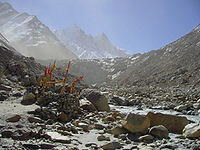
Around the snout, nature presents a wild topography. There are bolders scattered here and there with some pieces of broken snow, along with the hard clayey snow of the glacier.
The Gomukh snout is rapidly moving backwards. According to the modern research the snout has moved 1 km in just 70 years.
9 km ahead of Gangotri is Chirbasa, the abode of Chir trees. After 3 km of Chirbasa comes the dangerous Gila Pahar, the place well known for its landslide
s. Here the Bharals, a type of mountain antelopr are sometimes seen. The Bharals are found above the altitude of 10,000 ft. Only 4 km from here is Bhujbasa, the only night halting place on the way. One can stay at the GMVN Bunglow, or at the Lalbaba's Ashram at a lower cost. After trekking 41/2km from Bhujbasa, one reaches Gomukh, the snout of the Gangotri Glacier. A little before Gomukh, the majestic view of Mt. Shivling
welcomes the trekkers to the place.
On the trail no horse
s are allowed, so one must take preparations to walk on foot.
The trek to Tapovanan and Nandanvan starts from here.
 Some boulders make the route after 'Bhujbasa' quite difficult. One has to cross a boulder zone to reach near the Gomukh snout.
The trek beyond Gomukh is quite difficult. Crossing the glacier & going towards Tapovan is become quite dangerous nowadays (because of the landslides). There is actually no road, one must have a guide and should be prepare to face any type of accident which can even a life-threatening one. The last climb to reach Tapovan
is very stiff, within 2 km a stiff of about 70 degree, which gain a height of around 1500 foot and is quite a challenging experience.
Glacier terminus
A glacier terminus, or snout, is the end of a glacier at any given point in time. Although glaciers seem motionless to the observer, in reality glaciers are in endless motion and the glacier terminus is always either advancing or retreating...
or snout of the Gangotri Glacier
Gangotri Glacier
Gangotri Glacier is located in Uttarkashi District, Uttarakhand, India in a region bordering China. This glacier, source of the Ganges, is one of the largest in the Himalayas with an estimated volume of over 27 cubic kilometers. The glacier is about 30 kilometres long and 2 to 4 km wide...
, from where Bhagirathi River
Bhagirathi River
The Bhāgīrathī is a turbulent Himalayan river in the state of Uttarakhand, India, that is the source stream of the Ganges—the major river of the Gangetic plain of Northern India and the holy river of Hinduism.-Etymology:...
originates. The place is situated at a height of 11,500 ft. It is one of the largest in the Himalayas with an estimated volume of over 27 cubic kilometers.
Gomukh is also referred to as "Gaumukh" or "Gomukhi" (গোমুখ or গোমুখী).
The word "Gomukh" (go + mukh) literally means "Mouth of a Cow". According to some sayings, earlier the snout exactly looked like "Mouth of a Cow".
In ancient times
Gomukh is mentioned in the PuranasPuranas
The Puranas are a genre of important Hindu, Jain and Buddhist religious texts, notably consisting of narratives of the history of the universe from creation to destruction, genealogies of kings, heroes, sages, and demigods, and descriptions of Hindu cosmology, philosophy, and geography.Puranas...
. It is said there that searching a lost sheep a shepherd boy reached near a glacier in Gangotri, the snout of which exactly looked like the mouth of a cow, and thus it got its name 'Gomukh'. From then many saints, holy travellers, as well as religious people went there to worship the place.
Geography
Gomukh is 18 km from Gangotri in the foot hills of Bhagirathi at a height of 4255m. It is the snout of the Gangotri Glacier. The Bhagirathi river here is pretty speedy.Around the snout, nature presents a wild topography. There are bolders scattered here and there with some pieces of broken snow, along with the hard clayey snow of the glacier.
The Gomukh snout is rapidly moving backwards. According to the modern research the snout has moved 1 km in just 70 years.
Trek route
The trail to Gomukh begins from Gangotri, about 22 km (13.7 mi) from Gomukh.9 km ahead of Gangotri is Chirbasa, the abode of Chir trees. After 3 km of Chirbasa comes the dangerous Gila Pahar, the place well known for its landslide
Landslide
A landslide or landslip is a geological phenomenon which includes a wide range of ground movement, such as rockfalls, deep failure of slopes and shallow debris flows, which can occur in offshore, coastal and onshore environments...
s. Here the Bharals, a type of mountain antelopr are sometimes seen. The Bharals are found above the altitude of 10,000 ft. Only 4 km from here is Bhujbasa, the only night halting place on the way. One can stay at the GMVN Bunglow, or at the Lalbaba's Ashram at a lower cost. After trekking 41/2km from Bhujbasa, one reaches Gomukh, the snout of the Gangotri Glacier. A little before Gomukh, the majestic view of Mt. Shivling
Shivling (Garhwal Himalaya)
Shivling is a mountain in the Gangotri Group of peaks in the western Garhwal Himalaya, near the snout of the Gangotri Glacier. It lies in the northern Indian state of Uttarakhand, south of the Hindu holy site of Gaumukh . Its name refers to its status as a sacred symbol of the God - Lord Shiva's...
welcomes the trekkers to the place.
On the trail no horse
Horse
The horse is one of two extant subspecies of Equus ferus, or the wild horse. It is a single-hooved mammal belonging to the taxonomic family Equidae. The horse has evolved over the past 45 to 55 million years from a small multi-toed creature into the large, single-toed animal of today...
s are allowed, so one must take preparations to walk on foot.
The trek to Tapovanan and Nandanvan starts from here.
The trek beyond Gomukh is quite difficult. Crossing the glacier & going towards Tapovan is become quite dangerous nowadays (because of the landslides). There is actually no road, one must have a guide and should be prepare to face any type of accident which can even a life-threatening one. The last climb to reach Tapovan
Tapovan
Tapovan comes from the two root words Tapasya - meaning specifically austerity, and more generally spiritual practice, and Vana, meaning forest, or wilderness...
is very stiff, within 2 km a stiff of about 70 degree, which gain a height of around 1500 foot and is quite a challenging experience.