

Gold mining in the United States
Encyclopedia
Gold mining in the United States has taken place continually since the discovery of gold at the Reed farm
in North Carolina
in 1799. The first documented occurrence of gold was in Virginia in 1782. Some minor gold production took place in North Carolina as early as 1793, but created no excitement until the discovery on the Reed farm in 1799.
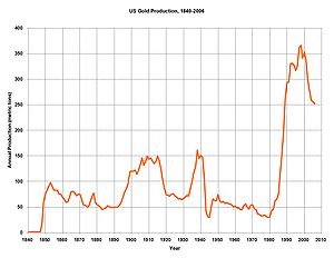 US gold production greatly increased during the 1980s, due to high gold prices and the use of heap leaching
to recover gold from disseminated low-grade deposits in Nevada and other states.
In 2007 the United States
produced approximately 240 tonnes of gold, making it the fourth-largest gold-producing nation, behind Australia
, South Africa
, and China
. Most gold produced today in the US comes from large open-pit heap leach mines in the state of Nevada
. The US is a net exporter of gold.
about 1830, shortly following the Georgia Gold Rush
. The principal districts were the Arbacoochee district in Cleburne County
, mostly from placer deposits, and the Hog Mountain district in Tallapoosa County
, which produced 24 thousand troy ounces (750 kg) from veins in schist
.
n explorers discovered placer gold in the Kenai River
in 1848, but no gold was produced. Gold mining started in 1870 from placers southeast of Juneau
. Today, most gold production in Alaska
is from the Fort Knox mine, a large open pit and cyanide leaching operation in the Fairbanks mining district
. The Fort Knox mine produced 333 thousand troy ounces (10.3 tonnes) of gold in 2006. Alaska produced a total of 40.3 million troy ounces of gold from 1880 through the end of 2007.
has produced more than 16 million troy ounces (498 tonnes) of gold.
Gold mining in Arizona reportedly began in 1774 when Spanish
priest Manuel Lopez directed Papago Indians to wash gold from gravel on the flanks of the Quijotoa Mountains, Pima County
. Gold mining continued there until 1849, when the Mexican miners were lured away by the California Gold Rush
. Other gold mining under Spanish and Mexican rule took place in the Oro Blanco district of Santa Cruz County, and the Arivaca district, Pima County.
Mountain man Pauline Weaver
discovered placer gold on the east side of the Colorado River in 1862. Weaver's discovery started a gold rush to the now ghost town of La Paz, Arizona
.
The gold-bearing quartz veins of the Vulture Mine
, southwest of Wickenburg
, in Maricopa County were discovered in 1863. The mine produced 366 thousand ounces of gold through 1959.
The San Francisco district, which includes the towns of Oatman
and Katherine in Mohave County
was discovered in 1863 or 1864, but saw little activity until a rush to the district occurred in 1902. The district produced 2.0 million ounces of gold through 1959.
The last gold mine to operate in Arizona was the Gold Road mine at Oatman
, which shut down in 1998. Patriot Gold is exploration drilling at the Moss mine at Oatman
. Columbus Gold is currently doing exploration drilling for gold at four prospects in western Arizona.
In 2006, all of Arizona's gold production came as a byproduct of copper mining.
, in present Imperial County, California
, about ten miles northeast from Yuma, Arizona
. The gold was recovered from dry placers. Other placer deposits on the west bank of the Colorado River
were quickly discovered, including the Picacho
and Cargo Muchacho districts.
Placer gold deposits were discovered at San Ysidro in San Diego County
in 1828, San Francisquito Canyon and Placerita Canyon in Los Angeles County
in 1835 and 1842, respectively
 Major gold mining in California
started in 1848 during the California Gold Rush
. Gold production in California
peaked in 1852, at 3.9 million troy ounces (121 tonnes) produced in that year. But the placer deposits worked in the early years were quickly exhausted, and production crashed. Hardrock mining (in California called quartz mining) began in 1849, and placer mining by hydraulic mining began in 1852. Despite the new mining methods, by 1865 production was 867 thousand troy ounces (27 tonnes), less than one-quarter of peak production.
Production sank to 412 thousand troy ounces (12.8 tonnes) in 1929, but then soared to more than 1.4 million troy ounces (43.5 tonnes) for each year 1939 through 1941, after the price was raised from $20.67 to $35 per ounce. However, the federal government, in War Production Board
Order L-208, ordered gold mines closed, to free up resources for the war effort during World War II
, and production fell to 148 thousand troy ounces (4.6 tonnes) in 1943. Post-war gold production never reached the peak of the early 1940s, as inflation and the fixed price of gold eroded its value.
The largest gold-mining district in California is the famous Mother Lode
of the Sierra Nevada. Discovered in the early 1850s, the lode is a zone one to four miles wide and running 120 miles northwest-southeast from El Dorado County
in the north, through Amador
, Calaveras
, and Tuolumne
counties, to Mariposa County
in the south. The gold of the Mother Lode
is in quartz veins within phyllite
, schist
, slate
, and greenstone
. Through 1959, the Mother Lode
produced about 13.3 million troy ounces (414 tonnes) of gold.
The second-largest gold-mining district in California was Grass Valley
-Nevada City
district in Nevada County
. Gold in Holocene
gravels was discovered in 1850, followed a few years later by hydraulic mining
of Tertiary
gravels. By 1880, most of the mining had shifted to lode deposits, such as the Empire Mine. Through 1959, the district produced 10.4 million troy ounces (323 tonnes) of lode gold, and 2.2 million troy ounces (68.4 tonnes) of placer gold.
The rich placer deposits of the Columbia Basin-Jamestown
-Sonora
district were discovered in 1853. Almost all the gold was found at the base of Quaternary
gravels, but some drift mines were worked in Tertiary
gravels. Total production was about 5.9 million troy ounces (183 tonnes) of gold.
In 2007, California produced 9,400 ounces (1603 kg) of gold from two mines. The Mesquite mine
in Imperial County
restarted active mining in 2007, having been inactive since 2001; now owned by New Gold, it produces more than 100,000 ounces (3.1 t) of gold per year. The only other gold producer in the state, the Briggs mine in Inyo County
stopped mining in 2004, but continues to produce small amounts of gold from the leach pads, from previously mined ore.
Emgold Mining is going through the permitting process to reopen the Idaho Maryland gold mine at Grass Valley
, Nevada County.
in 1858, but the deposits were small. The first important gold discoveries in Colorado were in the Central City
-Idaho Springs
district in January 1859. Three Colorado mines continue to produce gold. The Cripple Creek & Victor mine at Victor
, an open-pit heap leach operation owned by AngloGold Ashanti
, is the leading producer, with 283 thousand troy ounces (8.8 tonnes) of gold in 2006. Other active gold mines in the state are underground Golden Wonder mine near Lake City
, and the Cash and Rex mines in the Gold Hill
mining district in Boulder County, Colorado
.
See also:
at the juncture where canal creek meets orofino creek.
The leading historical gold-producing district is the Boise
Basin in Boise County
, which was discovered in 1862 and produced 2.9 million troy ounces (90.2 tonnes), mostly from placers.
The French Creek-Florence district in Idaho County
began in the 1860s, and has produced about 1 million troy ounces (31 tonnes) from placers.
The Silver City
district in Owyhee County
began producing in 1863, and made over 1 million troy ounces (31 tonnes), mostly from lode deposits.
The Coeur d’Alene district in Shoshone County
has made 440 thousand troy ounces (13.7 tonnes) of gold as byproduct to silver mining.
In 2006, active gold mines in Idaho
included the Silver Strand mine and the Bond mine.
as early as 1830, but no production resulted. Placer gold was discovered at Great Falls near Washington, DC in 1861 during the American Civil War
by Union soldiers from California. After the war a number of mines were opened on gold-bearing quartz
veins in Montgomery County
. No gold production has been reported since 1951. Total production was about 6 thousand troy ounces (190 kg).
in Marquette County, Michigan
. The underground mine, originally operated from 1880 to 1897, and reopened from 1983–1989,
extracted gold from quartz
veins in peridotite
.
in 1852, but mining did not begin until 1862, when gold placers were discovered at Bannack, Montana
in 1862. The resulting gold rush resulted in more placer discoveries, including those at Virginia City
in 1863, and at Helena
and Butte
in 1864. In 1867, the Atlantic Cable Quartz Lode
was located.
The Butte district, although mined primarily for copper, produced 2.9 million ounces (91 tones) of gold through 1990, almost all as a byproduct of copper production.
Current active hardrock gold mines include the Montana Tunnels mine, and the Golden Sunlight mine
. Active gold placers include the Browns Gulch placer and the Confederate Gulch placer. Gold is also produced from three platinum mines in the Stillwater igneous complex
: the Stillwater mine, the Lodestar mine, and the East Boulder Project.
is now the leading gold-producing state in the nation, in 2007 producing 80% of the gold mined in the United States. Almost all the gold in Nevada comes from large open pit mining and cyanide heap leaching
recovery. A number of major mining companies, such as Newmont Mining
, operate gold mines in the state. Active gold mines include Jerritt Canyon and the Getchell Mine
.
. The placer gold discovery was followed by discovery of a nearby lode deposit.
In 2007 all gold production in New Mexico (13 thousand troy ounces) came as a byproduct of hopper
mining from two large open pit mines in Grant County
. However, two primary gold mines are being readied for production: the Northstar mine in Rio Arriba County, and the San Lorenzo Claims mine in Socorro County.
was the site of the first gold rush in the United States, following the discovery of a 17 pound (7.7 kg) gold nugget by 12-year old Conrad Reed in a creek at his father’s farm in 1799. The Reed Gold Mine
, southwest of Georgeville in Cabarrus County, North Carolina
produced about 50 thousand troy ounces (1.6 tonnes) of gold from lode and placer deposits.
Gold was produced from 15 districts, almost all in the Piedmont region of the state. Total gold production is estimated at 1.2 million troy ounces (37.3 tonnes).
, almost all of the gold produced has come from two principal areas: the Klamath Mountains
in southwest Oregon, including Coos, Curry, Douglas, Jackson and Josephine counties; and the Blue Mountains
in northeast Oregon, mostly in Baker and Grant counties.
Prospectors from Illinois
discovered placer gold in the Klamath Mountains of southwest Oregon in 1850, starting a rush to the area. Lode gold deposits were also discovered.
Travellers along the Oregon Trail
bound for the Willamette Valley
are said to have discovered gold in northeastern Oregon in 1845, but mining in earnest did not begin until 1861.
five miles south of Lebanon
, Lebanon County, Pennsylvania
. Although the deposit produced iron since 1742, no gold was reported from the mine until 1908.
The Haile deposit was discovered in Lancaster County in 1827, and at least 275 thousand ounces of gold were extracted intermittently between then and 1942, when the gold mine was ordered closed as nonessential to the war effort. Beginning in 1951, the deposit was mined for associated sericite, which was used as a white filler. Gold is associated with silicic, kaolinitic, and pyritic alteration of greenschist-grade felsic metavolcanics. The mine was reopened as an open pit in the 1980s, and operated until 1992. Kinross Gold Corporation's reclamation of the Haile site was nominated for a US Bureau of Land Management
"Hardrock Mineral Environmental Award."
The Brewer mine operated from 1828 to 1995, and is now a federal Superfund
site.
Kennecott Minerals operated the Ridgeway open-pit gold mine from 1988 to 1999, and the land is now being reclaimed by Kennecott.
The Barite Hill mine operated from 1990 to 1994.
is the Wharf mine, an open pit heap leach operation.
About 15 thousand troy ounces (450 kg) of gold was recovered from the massive sulfide copper ores at Ducktown, Tennessee
.
of central Texas
. Gold prospects include the Heath mine and the Babyhead district, both in Llano County
, and the Central Texas mine in Gillespie County
. Gold production, if any, is not known.
today is a byproduct of the huge Bingham Canyon copper mine
, southwest of Salt Lake City. In 2006, the Bingham Canyon mine produced 16.3 tonnes of gold, making it the fourth-largest gold producer in the US. Over its life, Bingham Canyon has produced more than 23 million ounces (715 tonnes) of gold.
The Barneys Canyon mine in Salt Lake County
, the last primary gold mine to operate in Utah
, stopped mining in 2001, but is still recovering gold from its heap leaching
pads. Utah gold production was 460 thousand troy ounces (14 tonnes) in 2006.
-Sweetwater district in present Fremont County in 1842. The placers were worked intermittently until 1867, when the first important gold vein was discovered, and prospectors and miners rushed to the area.. The towns of South Pass City
, Atlantic City
, and Miner's Delight
catered to the miners. The district was nearly deserted by 1875, and was worked only intermittently afterward. Total gold production was about 300 thousand troy ounces (9.3 tonnes). In 1962, the district became the site of a major iron mine.
, on which the mining companies pay no royalties
to the US government. Gold mines operate under the General Mining Act of 1872
, which permits mineral mining on public land without payment of royalties. Fighting reforms to have the gold mining industry pay royalties, the local community commission in Elko County, Nevada
said that royalties would force mining companies to cut jobs and move elsewhere.
Maryland
Texas
Utah
National
Reed Gold Mine
The Reed Gold Mine is located in Midland, Cabarrus County, North Carolina, and is the site of the first documented commercial gold find in the United States...
in North Carolina
North Carolina
North Carolina is a state located in the southeastern United States. The state borders South Carolina and Georgia to the south, Tennessee to the west and Virginia to the north. North Carolina contains 100 counties. Its capital is Raleigh, and its largest city is Charlotte...
in 1799. The first documented occurrence of gold was in Virginia in 1782. Some minor gold production took place in North Carolina as early as 1793, but created no excitement until the discovery on the Reed farm in 1799.
Heap leaching
Heap leaching is an industrial mining process to extract precious metals, copper, uranium, and other compounds from ore.The process has ancient origins; one of the classical methods for the manufacture of copperas was to heap up iron pyrite and collect the leachate from the heap, which was then...
to recover gold from disseminated low-grade deposits in Nevada and other states.
In 2007 the United States
United States
The United States of America is a federal constitutional republic comprising fifty states and a federal district...
produced approximately 240 tonnes of gold, making it the fourth-largest gold-producing nation, behind Australia
Australia
Australia , officially the Commonwealth of Australia, is a country in the Southern Hemisphere comprising the mainland of the Australian continent, the island of Tasmania, and numerous smaller islands in the Indian and Pacific Oceans. It is the world's sixth-largest country by total area...
, South Africa
South Africa
The Republic of South Africa is a country in southern Africa. Located at the southern tip of Africa, it is divided into nine provinces, with of coastline on the Atlantic and Indian oceans...
, and China
China
Chinese civilization may refer to:* China for more general discussion of the country.* Chinese culture* Greater China, the transnational community of ethnic Chinese.* History of China* Sinosphere, the area historically affected by Chinese culture...
. Most gold produced today in the US comes from large open-pit heap leach mines in the state of Nevada
Nevada
Nevada is a state in the western, mountain west, and southwestern regions of the United States. With an area of and a population of about 2.7 million, it is the 7th-largest and 35th-most populous state. Over two-thirds of Nevada's people live in the Las Vegas metropolitan area, which contains its...
. The US is a net exporter of gold.
Alabama
Gold was discovered in AlabamaAlabama
Alabama is a state located in the southeastern region of the United States. It is bordered by Tennessee to the north, Georgia to the east, Florida and the Gulf of Mexico to the south, and Mississippi to the west. Alabama ranks 30th in total land area and ranks second in the size of its inland...
about 1830, shortly following the Georgia Gold Rush
Georgia Gold Rush
The Georgia Gold Rush was the second significant gold rush in the United States. It started in 1828 in the present day Lumpkin County near county seat Dahlonega, and soon spread through the North Georgia mountains, following the Georgia Gold Belt. By the early 1840s, gold became harder to find...
. The principal districts were the Arbacoochee district in Cleburne County
Cleburne County, Alabama
Cleburne County is a county of the U.S. state of Alabama. Its name is in honor of Major General Patrick Cleburne, of Arkansas. As of 2010 the population was 14,972. Its county seat is Heflin.- History :...
, mostly from placer deposits, and the Hog Mountain district in Tallapoosa County
Tallapoosa County, Alabama
Tallapoosa County is a county of the U.S. state of Alabama. The name Tallapoosa is of Creek origin, and many Indian villages were along the banks of the lower river before the 19th century. As of 2010, the population was 41,616...
, which produced 24 thousand troy ounces (750 kg) from veins in schist
Schist
The schists constitute a group of medium-grade metamorphic rocks, chiefly notable for the preponderance of lamellar minerals such as micas, chlorite, talc, hornblende, graphite, and others. Quartz often occurs in drawn-out grains to such an extent that a particular form called quartz schist is...
.
Alaska
RussiaRussia
Russia or , officially known as both Russia and the Russian Federation , is a country in northern Eurasia. It is a federal semi-presidential republic, comprising 83 federal subjects...
n explorers discovered placer gold in the Kenai River
Kenai River
The Kenai River called Kakny in the Dena'ina language, is a river in the Kenai Peninsula of south central Alaska. It runs westward from Kenai Lake in the Kenai Mountains, through the Kenai National Wildlife Refuge and Skilak Lake to its outlet into the Cook Inlet of the Pacific Ocean near Kenai...
in 1848, but no gold was produced. Gold mining started in 1870 from placers southeast of Juneau
Juneau mining district
The Juneau mining district is a gold mining area in the U.S. state of Alaska.In 1880 a local inhabitant, Chief Kowee, revealed to prospectors Joe Juneau and Richard Harris the presence of gold in what is now named Gold Creek in Silver Bow Basin...
. Today, most gold production in Alaska
Alaska
Alaska is the largest state in the United States by area. It is situated in the northwest extremity of the North American continent, with Canada to the east, the Arctic Ocean to the north, and the Pacific Ocean to the west and south, with Russia further west across the Bering Strait...
is from the Fort Knox mine, a large open pit and cyanide leaching operation in the Fairbanks mining district
Fairbanks mining district
The Fairbanks mining district is a gold-mining area in the U.S. state of Alaska. Placer mining began near Fairbanks in July 1902, after Felix Pedro , an Italian immigrant and Tom Gilmore discovered gold in the hills north of the Tanana and Chena Rivers in 1901. Pedro died exactly eight years after...
. The Fort Knox mine produced 333 thousand troy ounces (10.3 tonnes) of gold in 2006. Alaska produced a total of 40.3 million troy ounces of gold from 1880 through the end of 2007.
Arizona
ArizonaArizona
Arizona ; is a state located in the southwestern region of the United States. It is also part of the western United States and the mountain west. The capital and largest city is Phoenix...
has produced more than 16 million troy ounces (498 tonnes) of gold.
Gold mining in Arizona reportedly began in 1774 when Spanish
Spanish people
The Spanish are citizens of the Kingdom of Spain. Within Spain, there are also a number of vigorous nationalisms and regionalisms, reflecting the country's complex history....
priest Manuel Lopez directed Papago Indians to wash gold from gravel on the flanks of the Quijotoa Mountains, Pima County
Pima County, Arizona
-2010:Whereas according to the 2010 U.S. Census Bureau:*74.3% White*3.5% Black*3.3% Native American*2.6% Asian*0.2% Native Hawaiian or Pacific Islander*3.7% Two or more races*12.4% Other races*34.6% Hispanic or Latino -2000:...
. Gold mining continued there until 1849, when the Mexican miners were lured away by the California Gold Rush
California Gold Rush
The California Gold Rush began on January 24, 1848, when gold was found by James W. Marshall at Sutter's Mill in Coloma, California. The first to hear confirmed information of the gold rush were the people in Oregon, the Sandwich Islands , and Latin America, who were the first to start flocking to...
. Other gold mining under Spanish and Mexican rule took place in the Oro Blanco district of Santa Cruz County, and the Arivaca district, Pima County.
Mountain man Pauline Weaver
Pauline Weaver
Pauline Weaver , also called Paulino Weaver, was an American mountain man, trapper, military scout, prospector, and explorer who was active in the early southwestern United States...
discovered placer gold on the east side of the Colorado River in 1862. Weaver's discovery started a gold rush to the now ghost town of La Paz, Arizona
La Paz, Arizona
La Paz was a short-lived, early gold mining town along the Colorado River in La Paz County on the western border of the U.S. state of Arizona. It was the location of the La Paz Incident in 1863, the westernmost confrontation of the American Civil War. The town was settled in 1862 in what was then...
.
The gold-bearing quartz veins of the Vulture Mine
Vulture Mine
The Vulture Mine was a gold mine and settlement in Maricopa County, Arizona, United States. The mine began in 1863 and became the most productive gold mine in Arizona history. From 1863 to 1942, the mine produced 340,000 ounces of gold and 260,000 ounces of silver...
, southwest of Wickenburg
Wickenburg, Arizona
Wickenburg is a town in Maricopa County, Arizona, United States. According to 2006 Census Bureau estimates, the population of the town is 6,423.-Geography:Wickenburg is located at ....
, in Maricopa County were discovered in 1863. The mine produced 366 thousand ounces of gold through 1959.
The San Francisco district, which includes the towns of Oatman
Oatman, Arizona
Oatman is a former mining town in the Black Mountains of Mohave County, Arizona, United States. Located at an elevation of , it began as a tent camp soon after two prospectors struck a $10 million gold find in 1915, though the area had been already settled for a number of years. Oatman's...
and Katherine in Mohave County
Mohave County, Arizona
Mohave County is located in the northwestern corner of the U.S. state of Arizona. As of the 2010 census, its population was 200,186, an increase of 45,154 people since the 2000 census count of 155,032. The county seat is Kingman...
was discovered in 1863 or 1864, but saw little activity until a rush to the district occurred in 1902. The district produced 2.0 million ounces of gold through 1959.
The last gold mine to operate in Arizona was the Gold Road mine at Oatman
Oatman, Arizona
Oatman is a former mining town in the Black Mountains of Mohave County, Arizona, United States. Located at an elevation of , it began as a tent camp soon after two prospectors struck a $10 million gold find in 1915, though the area had been already settled for a number of years. Oatman's...
, which shut down in 1998. Patriot Gold is exploration drilling at the Moss mine at Oatman
Oatman, Arizona
Oatman is a former mining town in the Black Mountains of Mohave County, Arizona, United States. Located at an elevation of , it began as a tent camp soon after two prospectors struck a $10 million gold find in 1915, though the area had been already settled for a number of years. Oatman's...
. Columbus Gold is currently doing exploration drilling for gold at four prospects in western Arizona.
In 2006, all of Arizona's gold production came as a byproduct of copper mining.
California
Spanish prospectors discovered gold in the Potholes district between 1775 and 1780, along the Colorado RiverColorado River
The Colorado River , is a river in the Southwestern United States and northwestern Mexico, approximately long, draining a part of the arid regions on the western slope of the Rocky Mountains. The watershed of the Colorado River covers in parts of seven U.S. states and two Mexican states...
, in present Imperial County, California
Imperial County, California
Imperial County is a county located in the Imperial Valley, in the far southeast of the U.S. state of California, bordering both Arizona and Mexico. It is part of the El Centro Metropolitan Area, which encompasses all of Imperial County. The population as of 2000 was 142,361. The county seat is the...
, about ten miles northeast from Yuma, Arizona
Yuma, Arizona
Yuma is a city in and the county seat of Yuma County, Arizona, United States. It is located in the southwestern corner of the state, and the population of the city was 77,515 at the 2000 census, with a 2008 Census Bureau estimated population of 90,041....
. The gold was recovered from dry placers. Other placer deposits on the west bank of the Colorado River
Colorado River
The Colorado River , is a river in the Southwestern United States and northwestern Mexico, approximately long, draining a part of the arid regions on the western slope of the Rocky Mountains. The watershed of the Colorado River covers in parts of seven U.S. states and two Mexican states...
were quickly discovered, including the Picacho
Picacho, California
Picacho is an unincorporated community in Imperial County, California. It is located on the Colorado River south-southeast of Palo Verde, at an elevation of 203 feet .Picacho, now a ghost town, was an early mining town on the Colorado River...
and Cargo Muchacho districts.
Placer gold deposits were discovered at San Ysidro in San Diego County
San Diego, California
San Diego is the eighth-largest city in the United States and second-largest city in California. The city is located on the coast of the Pacific Ocean in Southern California, immediately adjacent to the Mexican border. The birthplace of California, San Diego is known for its mild year-round...
in 1828, San Francisquito Canyon and Placerita Canyon in Los Angeles County
Los Angeles County, California
Los Angeles County is a county in the U.S. state of California. As of 2010 U.S. Census, the county had a population of 9,818,605, making it the most populous county in the United States. Los Angeles County alone is more populous than 42 individual U.S. states...
in 1835 and 1842, respectively
Gold in California
Gold in California became highly concentrated there as the result of global forces operating over hundreds of millions of years. Volcanoes, tectonic plates and erosion all combined to concentrate billions of dollars worth of gold in the mountains of California...
started in 1848 during the California Gold Rush
California Gold Rush
The California Gold Rush began on January 24, 1848, when gold was found by James W. Marshall at Sutter's Mill in Coloma, California. The first to hear confirmed information of the gold rush were the people in Oregon, the Sandwich Islands , and Latin America, who were the first to start flocking to...
. Gold production in California
California
California is a state located on the West Coast of the United States. It is by far the most populous U.S. state, and the third-largest by land area...
peaked in 1852, at 3.9 million troy ounces (121 tonnes) produced in that year. But the placer deposits worked in the early years were quickly exhausted, and production crashed. Hardrock mining (in California called quartz mining) began in 1849, and placer mining by hydraulic mining began in 1852. Despite the new mining methods, by 1865 production was 867 thousand troy ounces (27 tonnes), less than one-quarter of peak production.
Production sank to 412 thousand troy ounces (12.8 tonnes) in 1929, but then soared to more than 1.4 million troy ounces (43.5 tonnes) for each year 1939 through 1941, after the price was raised from $20.67 to $35 per ounce. However, the federal government, in War Production Board
War Production Board
The War Production Board was established as a government agency on January 16, 1942 by executive order of Franklin D. Roosevelt.The purpose of the board was to regulate the production and allocation of materials and fuel during World War II in the United States...
Order L-208, ordered gold mines closed, to free up resources for the war effort during World War II
World War II
World War II, or the Second World War , was a global conflict lasting from 1939 to 1945, involving most of the world's nations—including all of the great powers—eventually forming two opposing military alliances: the Allies and the Axis...
, and production fell to 148 thousand troy ounces (4.6 tonnes) in 1943. Post-war gold production never reached the peak of the early 1940s, as inflation and the fixed price of gold eroded its value.
The largest gold-mining district in California is the famous Mother Lode
Mother Lode
Mother lode is a principal vein or zone of veins of gold or silver ore. The term probably came from a literal translation of the Spanish veta madre, a term common in old Mexican mining...
of the Sierra Nevada. Discovered in the early 1850s, the lode is a zone one to four miles wide and running 120 miles northwest-southeast from El Dorado County
El Dorado County, California
El Dorado County is a county located in the historic Gold Country in the Sierra Nevada Mountains and foothills of the U.S. state of California. The 2010 population was 181,058. The El Dorado county seat is in Placerville....
in the north, through Amador
Amador County, California
Amador County is a county located in the Sierra Nevada of the U.S. state of California. As of the 2010 census, the population was 38,091. The county seat is Jackson.Amador County bills itself as "The Heart of the Mother Lode" and lies within the Gold Country...
, Calaveras
Calaveras County, California
Calaveras County is a county located in the Gold Country of the U.S. state of California. Calaveras is the Spanish word for skulls; the county was reportedly named for the remains of Native Americans discovered by the Spanish explorer Captain Gabriel Moraga. As of the 2010 census, the county had a...
, and Tuolumne
Tuolumne County, California
Tuolumne County is a county in the Sierra Nevada of the U.S. state of California. The northern half of Yosemite National Park is located in the eastern part of the county. As of the 2010 census, the population was 55,365, up from 54,501 at the 2000 census...
counties, to Mariposa County
Mariposa County, California
Mariposa County is a county in the U.S. state of California, located in the western foothills of the Sierra Nevada mountains. It lies north of Fresno, east of Merced, and southeast of Stockton. As of the 2010 census, the population was 18,251 up from 17,130 at the 2000 census...
in the south. The gold of the Mother Lode
Mother Lode
Mother lode is a principal vein or zone of veins of gold or silver ore. The term probably came from a literal translation of the Spanish veta madre, a term common in old Mexican mining...
is in quartz veins within phyllite
Phyllite
Phyllite is a type of foliated metamorphic rock primarily composed of quartz, sericite mica, and chlorite; the rock represents a gradation in the degree of metamorphism between slate and mica schist. Minute crystals of graphite, sericite, or chlorite impart a silky, sometimes golden sheen to the...
, schist
Schist
The schists constitute a group of medium-grade metamorphic rocks, chiefly notable for the preponderance of lamellar minerals such as micas, chlorite, talc, hornblende, graphite, and others. Quartz often occurs in drawn-out grains to such an extent that a particular form called quartz schist is...
, slate
Slate
Slate is a fine-grained, foliated, homogeneous metamorphic rock derived from an original shale-type sedimentary rock composed of clay or volcanic ash through low-grade regional metamorphism. The result is a foliated rock in which the foliation may not correspond to the original sedimentary layering...
, and greenstone
Greenschist
Greenschist is a general field petrologic term applied to metamorphic or altered mafic volcanic rock. The term greenstone is sometimes used to refer to greenschist but can refer to other rock types too. The green is due to abundant green chlorite, actinolite and epidote minerals that dominate the...
. Through 1959, the Mother Lode
Mother Lode
Mother lode is a principal vein or zone of veins of gold or silver ore. The term probably came from a literal translation of the Spanish veta madre, a term common in old Mexican mining...
produced about 13.3 million troy ounces (414 tonnes) of gold.
The second-largest gold-mining district in California was Grass Valley
Grass Valley, California
-2010:The 2010 United States Census reported that Grass Valley had a population of 12,860. The population density was 2,711.3 people per square mile . The racial makeup of Grass Valley was 11,493 White, 46 African American, 208 Native American, 188 Asian, 9 Pacific Islander, 419 from other...
-Nevada City
Nevada City, California
-2010:The 2010 United States Census reported that Nevada City had a population of 3,068. The population density was 1,399.7 people per square mile . The racial makeup of Nevada City was 2,837 White, 26 African American, 28 Native American, 46 Asian, 0 Pacific Islander, 40 from other races,...
district in Nevada County
Nevada County, California
Nevada County is a county located in the Sierra Nevada of California, in the Mother Lode country. As of 2010 its population was 98,764. The county seat is Nevada City.-History:Nevada County was created in 1851 from parts of Yuba County....
. Gold in Holocene
Holocene
The Holocene is a geological epoch which began at the end of the Pleistocene and continues to the present. The Holocene is part of the Quaternary period. Its name comes from the Greek words and , meaning "entirely recent"...
gravels was discovered in 1850, followed a few years later by hydraulic mining
Hydraulic mining
Hydraulic mining, or hydraulicking, is a form of mining that uses high-pressure jets of water to dislodge rock material or move sediment. In the placer mining of gold or tin, the resulting water-sediment slurry is directed through sluice boxes to remove the gold.-Precursor - ground...
of Tertiary
Tertiary
The Tertiary is a deprecated term for a geologic period 65 million to 2.6 million years ago. The Tertiary covered the time span between the superseded Secondary period and the Quaternary...
gravels. By 1880, most of the mining had shifted to lode deposits, such as the Empire Mine. Through 1959, the district produced 10.4 million troy ounces (323 tonnes) of lode gold, and 2.2 million troy ounces (68.4 tonnes) of placer gold.
The rich placer deposits of the Columbia Basin-Jamestown
Jamestown, California
Jamestown is a census-designated place in Tuolumne County, California, United States. The population was 3,433 at the 2010 census, up from 3,017 at the 2000 census.A scene from the movie Hidalgo was filmed in Jamestown...
-Sonora
Sonora, California
Sonora is the county seat of Tuolumne County, California. As of the 2010 census, the city population was 4,903, up from 4,423 at the 2000 census. Sonora is the only incorporated community in Tuolumne County.-Geography:...
district were discovered in 1853. Almost all the gold was found at the base of Quaternary
Quaternary
The Quaternary Period is the most recent of the three periods of the Cenozoic Era in the geologic time scale of the ICS. It follows the Neogene Period, spanning 2.588 ± 0.005 million years ago to the present...
gravels, but some drift mines were worked in Tertiary
Tertiary
The Tertiary is a deprecated term for a geologic period 65 million to 2.6 million years ago. The Tertiary covered the time span between the superseded Secondary period and the Quaternary...
gravels. Total production was about 5.9 million troy ounces (183 tonnes) of gold.
In 2007, California produced 9,400 ounces (1603 kg) of gold from two mines. The Mesquite mine
Mesquite Mine
The Mesquite Mine, operated by New Gold, is located in Glamis, Imperial County, California. It is one of the largest gold mines in the United States...
in Imperial County
Imperial County, California
Imperial County is a county located in the Imperial Valley, in the far southeast of the U.S. state of California, bordering both Arizona and Mexico. It is part of the El Centro Metropolitan Area, which encompasses all of Imperial County. The population as of 2000 was 142,361. The county seat is the...
restarted active mining in 2007, having been inactive since 2001; now owned by New Gold, it produces more than 100,000 ounces (3.1 t) of gold per year. The only other gold producer in the state, the Briggs mine in Inyo County
Inyo County, California
-National protected areas:* Death Valley National Park * Inyo National Forest * Manzanar National Historic Site-Major highways:* U.S. Route 6* U.S. Route 395* State Route 127* State Route 136* State Route 168* State Route 178...
stopped mining in 2004, but continues to produce small amounts of gold from the leach pads, from previously mined ore.
Emgold Mining is going through the permitting process to reopen the Idaho Maryland gold mine at Grass Valley
Grass Valley, California
-2010:The 2010 United States Census reported that Grass Valley had a population of 12,860. The population density was 2,711.3 people per square mile . The racial makeup of Grass Valley was 11,493 White, 46 African American, 208 Native American, 188 Asian, 9 Pacific Islander, 419 from other...
, Nevada County.
Colorado
Gold was discovered in 1858 during the Pike's Peak Gold Rush in the vicinity of present-day DenverDenver, Colorado
The City and County of Denver is the capital and the most populous city of the U.S. state of Colorado. Denver is a consolidated city-county, located in the South Platte River Valley on the western edge of the High Plains just east of the Front Range of the Rocky Mountains...
in 1858, but the deposits were small. The first important gold discoveries in Colorado were in the Central City
Central City, Colorado
Central City is a home rule municipality in Clear Creek and Gilpin counties in the U.S. state of Colorado, and the county seat of Gilpin County. The city population was 515 in the 2000 United States Census...
-Idaho Springs
Idaho Springs, Colorado
The City of Idaho Springs is a municipality in the U.S. state of Colorado that is the most populous settlement in Clear Creek County, Colorado. Idaho Springs is located in Clear Creek Canyon, in the mountains upstream from Golden, some thirty miles west of Denver...
district in January 1859. Three Colorado mines continue to produce gold. The Cripple Creek & Victor mine at Victor
Victor, Colorado
Victor is a Statutory City in Teller County, Colorado, United States. The population was 445 at the 2000 census.Victor is in the heart of Colorado's gold country, home to two of the major gold mines in the Cripple Creek mining district...
, an open-pit heap leach operation owned by AngloGold Ashanti
AngloGold Ashanti
AngloGold Ashanti Limited is a global gold mining company. It was formed in 2004 by the merger of AngloGold and the Ashanti Goldfields Corporation.AngloGold Ashanti Limited is now a global gold producer with 21 operations on four continents...
, is the leading producer, with 283 thousand troy ounces (8.8 tonnes) of gold in 2006. Other active gold mines in the state are underground Golden Wonder mine near Lake City
Lake City, Colorado
The Town of Lake City is a Statutory Town that is the county seat of, and the only incorporated municipality in, Hinsdale County, Colorado, United States. The town population was 375 at the U.S. Census 2000...
, and the Cash and Rex mines in the Gold Hill
Gold Hill, Colorado
Gold Hill is a census-designated place in Boulder County, Colorado, United States. The population was 230 at the 2010 census.This settlement is located to the northwest of Boulder, perched on a mountainside above Left Hand Canyon at an elevation of 8,300 feet...
mining district in Boulder County, Colorado
Boulder County, Colorado
Boulder County is the sixth most populous of the 64 counties of the state of Colorado of the United States. The county seat is Boulder. The most populous municipality in the county and the county seat is the City of Boulder...
.
Georgia
Georgia is credited with a total historical production of 871 thousand ounces of gold from 1830 through 1959. Although a historically important gold producer, the state does not presently produce any gold.See also:
- Battle Branch MineBattle Branch MineThe Battle Branch Mine, sometimes referred to as the Battle Creek Mine, was located near the town of Auraria in Lumpkin County, Georgia. During the Georgia Gold Rush, before the Gold Lottery of 1832, men from several different states were all working in the same stream when a dispute over the...
- Calhoun MineCalhoun MineThe Calhoun Mine is perhaps the oldest and best known mine in Lumpkin County, Georgia. When gold was discovered in Lumpkin County in 1828, which lead to the Georgia Gold Rush in 1829, it was discovered on owned by Robert Obar. After at least two intermediary sales, the land was purchased by...
- Consolidated MineConsolidated MineThe Consolidated Mine was a gold mine in Lumpkin County, Georgia, United States, just east of Dahlonega. Like most of the area around Dahlonega, the placer mining on the land on which the mine is located probably started during the Georgia Gold Rush. By 1880, the placer deposits were exhausted and...
- Crisson Mine
- Franklin-Crieghton Mine
- Free Jim MineFree Jim MineThe Free Jim Mine was a Georgia Gold Rush gold mine located in the town of Dahlonega in Lumpkin County, Georgia, USA. The mine was started by a free African American named James Boisclair, who arrived in the area in the 1830's from Augusta, Georgia...
- Loud MineLoud MineLoud Mine was a gold mine in White County, Georgia north of Dahlonega; it was a famous mining site in the 19th century Georgia Gold Rush. The site is now owned by a private gold mining group, and permission is needed to go on the property.-External links:*...
- Sixes mineSixes mineThe Sixes Mine is a group of former gold placer mines in the Georgia Gold Belt. They are near Sixes in Cherokee County, Georgia, United States, located off Bell's Ferry Road, south of Canton, Georgia. The mine's coordinates are .-History:...
Idaho
Gold was first discovered in Idaho in 1860, in PiercePierce, Idaho
Pierce is a city in Clearwater County, Idaho. Elias D. Pierce and Wilbur F. Bassett made the first discovery of gold in Idaho , on Orofino Creek in 1860, a mile north of Pierce....
at the juncture where canal creek meets orofino creek.
The leading historical gold-producing district is the Boise
Boise, Idaho
Boise is the capital and most populous city of the U.S. state of Idaho, as well as the county seat of Ada County. Located on the Boise River, it anchors the Boise City-Nampa metropolitan area and is the largest city between Salt Lake City, Utah and Portland, Oregon.As of the 2010 Census Bureau,...
Basin in Boise County
Boise County, Idaho
Boise County is a rural mountain county in the U.S. state of Idaho. The population was 6,670 at the 2000 census; it was estimated at 7,571 in 2007...
, which was discovered in 1862 and produced 2.9 million troy ounces (90.2 tonnes), mostly from placers.
The French Creek-Florence district in Idaho County
Idaho County, Idaho
Idaho County is a county located in the U.S. state of Idaho. As of the 2010 Census the county had a population of 16,267. The county seat is Grangeville...
began in the 1860s, and has produced about 1 million troy ounces (31 tonnes) from placers.
The Silver City
Silver City, Idaho
Silver City is a ghost town in Owyhee County, Idaho, United States. At its height in the 1880s it was a gold and silver mining town with a population of around 2,500 and approximately 75 businesses. Silver City served as county seat of Owyhee County from 1867 to 1934. Today, the town has about 70...
district in Owyhee County
Owyhee County, Idaho
Owyhee County is a county located in the southwestern corner of the U.S. state of Idaho. In area it is the second largest county in Idaho, behind Idaho County. As of the 2000 Census, Owyhee County had a population of 10,644...
began producing in 1863, and made over 1 million troy ounces (31 tonnes), mostly from lode deposits.
The Coeur d’Alene district in Shoshone County
Shoshone County, Idaho
Shoshone County is a county located in the U.S. state of Idaho. The county was established in 1864, named for the Native American Shoshone tribe. The population was 12,765 at the 2010 census. Shoshone County is commonly referred to as the Silver Valley, due to its century-old mining history...
has made 440 thousand troy ounces (13.7 tonnes) of gold as byproduct to silver mining.
In 2006, active gold mines in Idaho
Idaho
Idaho is a state in the Rocky Mountain area of the United States. The state's largest city and capital is Boise. Residents are called "Idahoans". Idaho was admitted to the Union on July 3, 1890, as the 43rd state....
included the Silver Strand mine and the Bond mine.
Maryland
Gold was reported in MarylandMaryland
Maryland is a U.S. state located in the Mid Atlantic region of the United States, bordering Virginia, West Virginia, and the District of Columbia to its south and west; Pennsylvania to its north; and Delaware to its east...
as early as 1830, but no production resulted. Placer gold was discovered at Great Falls near Washington, DC in 1861 during the American Civil War
American Civil War
The American Civil War was a civil war fought in the United States of America. In response to the election of Abraham Lincoln as President of the United States, 11 southern slave states declared their secession from the United States and formed the Confederate States of America ; the other 25...
by Union soldiers from California. After the war a number of mines were opened on gold-bearing quartz
Quartz
Quartz is the second-most-abundant mineral in the Earth's continental crust, after feldspar. It is made up of a continuous framework of SiO4 silicon–oxygen tetrahedra, with each oxygen being shared between two tetrahedra, giving an overall formula SiO2. There are many different varieties of quartz,...
veins in Montgomery County
Montgomery County, Maryland
Montgomery County is a county in the U.S. state of Maryland, situated just to the north of Washington, D.C., and southwest of the city of Baltimore. It is one of the most affluent counties in the United States, and has the highest percentage of residents over 25 years of age who hold post-graduate...
. No gold production has been reported since 1951. Total production was about 6 thousand troy ounces (190 kg).
Michigan
Approximately 29 thousand troy ounces (900 kg) of gold were produced from the Ropes gold mine northeast of IshpemingIshpeming, Michigan
Ishpeming is a city in Marquette County in the Upper Peninsula of the U.S. state of Michigan. The population was 6,686 at the 2000 census. This is down from a higher population in the 1950s and 1960s when the economically supportive iron ore mines had a much higher employment level...
in Marquette County, Michigan
Marquette County, Michigan
-National protected areas:* Hiawatha National Forest * Huron National Wildlife Refuge* Ottawa National Forest -University:Northern Michigan University is a four-year university, established in 1899, located in Marquette, Michigan, on Michigan's Upper Peninsula...
. The underground mine, originally operated from 1880 to 1897, and reopened from 1983–1989,
extracted gold from quartz
Quartz
Quartz is the second-most-abundant mineral in the Earth's continental crust, after feldspar. It is made up of a continuous framework of SiO4 silicon–oxygen tetrahedra, with each oxygen being shared between two tetrahedra, giving an overall formula SiO2. There are many different varieties of quartz,...
veins in peridotite
Peridotite
A peridotite is a dense, coarse-grained igneous rock, consisting mostly of the minerals olivine and pyroxene. Peridotite is ultramafic, as the rock contains less than 45% silica. It is high in magnesium, reflecting the high proportions of magnesium-rich olivine, with appreciable iron...
.
Montana
Gold was first discovered in MontanaMontana
Montana is a state in the Western United States. The western third of Montana contains numerous mountain ranges. Smaller, "island ranges" are found in the central third of the state, for a total of 77 named ranges of the Rocky Mountains. This geographical fact is reflected in the state's name,...
in 1852, but mining did not begin until 1862, when gold placers were discovered at Bannack, Montana
Bannack, Montana
Bannack is a ghost town in Beaverhead County, Montana, United States, located on Grasshopper Creek, approximately upstream from where Grasshopper Creek joins with the Beaverhead River south of Dillon.-History:...
in 1862. The resulting gold rush resulted in more placer discoveries, including those at Virginia City
Virginia City, Montana
Virginia City is a town in and the county seat of Madison County, Montana, United States. In 1961, the town and the surrounding area was designated a National Historic Landmark District, the Virginia City Historic District...
in 1863, and at Helena
Helena, Montana
Helena is the capital city of the U.S. state of Montana and the county seat of Lewis and Clark County. The 2010 census put the population at 28,180. The local daily newspaper is the Independent Record. The Helena Brewers minor league baseball and Helena Bighorns minor league hockey team call the...
and Butte
Butte, Montana
Butte is a city in Montana and the county seat of Silver Bow County, United States. In 1977, the city and county governments consolidated to form the sole entity of Butte-Silver Bow. As of the 2010 census, Butte's population was 34,200...
in 1864. In 1867, the Atlantic Cable Quartz Lode
Atlantic Cable Quartz Lode
The Atlantic Cable Quartz Lode is a gold mine in Deer Lodge County, Montana. The mine is located in the southwestern area of Montana, between Drummond and Anaconda along the Pintler Scenic Route on Montana Highway 1, east of Georgetown Lake....
was located.
The Butte district, although mined primarily for copper, produced 2.9 million ounces (91 tones) of gold through 1990, almost all as a byproduct of copper production.
Current active hardrock gold mines include the Montana Tunnels mine, and the Golden Sunlight mine
Golden Sunlight mine
The Golden Sunlight mine is an open pit gold mine in Jefferson County, Montana, approximately east of Butte, Montana. The mine sits at an elevation of on the Bull Mountain range. The mine has been in operation since 1975, and in 2008, the mine produced of gold. The mine's proprietors estimate...
. Active gold placers include the Browns Gulch placer and the Confederate Gulch placer. Gold is also produced from three platinum mines in the Stillwater igneous complex
Stillwater igneous complex
The Stillwater igneous complex is a large layered intrusion located in southern Montana in Stillwater, Sweet Grass and Park Counties. The complex is exposed across 30 miles of the north flank of the Beartooth Mountain Range. The complex has extensive reserves of chromium ore and has a history of...
: the Stillwater mine, the Lodestar mine, and the East Boulder Project.
Nevada
NevadaNevada
Nevada is a state in the western, mountain west, and southwestern regions of the United States. With an area of and a population of about 2.7 million, it is the 7th-largest and 35th-most populous state. Over two-thirds of Nevada's people live in the Las Vegas metropolitan area, which contains its...
is now the leading gold-producing state in the nation, in 2007 producing 80% of the gold mined in the United States. Almost all the gold in Nevada comes from large open pit mining and cyanide heap leaching
Heap leaching
Heap leaching is an industrial mining process to extract precious metals, copper, uranium, and other compounds from ore.The process has ancient origins; one of the classical methods for the manufacture of copperas was to heap up iron pyrite and collect the leachate from the heap, which was then...
recovery. A number of major mining companies, such as Newmont Mining
Newmont Mining
Newmont Mining Corporation , based in Denver, Colorado, USA, is one of the world's largest producers of gold, with active mines in Nevada, Indonesia, Australia, New Zealand, Ghana and Peru. Holdings include Santa Fe Gold, Battle Mountain Gold, Normandy Mining, Franco-Nevada Corp and Fronteer Gold...
, operate gold mines in the state. Active gold mines include Jerritt Canyon and the Getchell Mine
Getchell Mine
Getchell Mine is an underground gold mine owned by both Barrick Gold, and Newmont Mining, and is located near Winnemucca, Nevada. The operation consists of two underground mines, the Getchell Mine, and Turquoise Ridge. The mining method currently used is drift and fill.The gold deposit is a...
.
New Mexico
Gold was first discovered in New Mexico in 1828 in the “Old Placers” district in the Ortiz Mountains, Santa Fe County, New MexicoSanta Fe County, New Mexico
-2010:Whereas according to the 2010 U.S. Census Bureau:*76.2% White*0.9% Black*3.1% Native American*1.2% Asian*0.1% Native Hawaiian or Pacific Islander*3.6% Two or more races*14.9% Other races*50.6% Hispanic or Latino -2000:...
. The placer gold discovery was followed by discovery of a nearby lode deposit.
In 2007 all gold production in New Mexico (13 thousand troy ounces) came as a byproduct of hopper
Hopper
Hopper may refer to:-Mechanical parts:* A general term for a chute with additional width and depth for temporary storage* Hopper , a large container used for dust collection* Part of a combine harvester...
mining from two large open pit mines in Grant County
Grant County, New Mexico
-2010:Whereas according to the 2010 U.S. Census Bureau:*84.9% White*0.9% Black*1.4% Native American*0.4% Asian*0.1% Native Hawaiian or Pacific Islander*2.8% Two or more races*9.8% Other races*48.3% Hispanic or Latino -2000:...
. However, two primary gold mines are being readied for production: the Northstar mine in Rio Arriba County, and the San Lorenzo Claims mine in Socorro County.
North Carolina
North CarolinaNorth Carolina
North Carolina is a state located in the southeastern United States. The state borders South Carolina and Georgia to the south, Tennessee to the west and Virginia to the north. North Carolina contains 100 counties. Its capital is Raleigh, and its largest city is Charlotte...
was the site of the first gold rush in the United States, following the discovery of a 17 pound (7.7 kg) gold nugget by 12-year old Conrad Reed in a creek at his father’s farm in 1799. The Reed Gold Mine
Reed Gold Mine
The Reed Gold Mine is located in Midland, Cabarrus County, North Carolina, and is the site of the first documented commercial gold find in the United States...
, southwest of Georgeville in Cabarrus County, North Carolina
Cabarrus County, North Carolina
-Demographics:As of the census of 2000, there were 131,063 people, 49,519 households, and 36,545 families residing in the county. The population density was 360 people per square mile . There were 52,848 housing units at an average density of 145 per square mile...
produced about 50 thousand troy ounces (1.6 tonnes) of gold from lode and placer deposits.
Gold was produced from 15 districts, almost all in the Piedmont region of the state. Total gold production is estimated at 1.2 million troy ounces (37.3 tonnes).
Oregon
Although gold mines are spread over much of OregonOregon
Oregon is a state in the Pacific Northwest region of the United States. It is located on the Pacific coast, with Washington to the north, California to the south, Nevada on the southeast and Idaho to the east. The Columbia and Snake rivers delineate much of Oregon's northern and eastern...
, almost all of the gold produced has come from two principal areas: the Klamath Mountains
Klamath Mountains
The Klamath Mountains, which include the Siskiyou, Marble, Scott, Trinity, Trinity Alps, Salmon, and northern Yolla-Bolly Mountains, are a rugged lightly populated mountain range in northwest California and southwest Oregon in the United States...
in southwest Oregon, including Coos, Curry, Douglas, Jackson and Josephine counties; and the Blue Mountains
Blue Mountains (Oregon)
The Blue Mountains are a mountain range in the western United States, located largely in northeastern Oregon and stretching into southeastern Washington...
in northeast Oregon, mostly in Baker and Grant counties.
Prospectors from Illinois
Illinois
Illinois is the fifth-most populous state of the United States of America, and is often noted for being a microcosm of the entire country. With Chicago in the northeast, small industrial cities and great agricultural productivity in central and northern Illinois, and natural resources like coal,...
discovered placer gold in the Klamath Mountains of southwest Oregon in 1850, starting a rush to the area. Lode gold deposits were also discovered.
Travellers along the Oregon Trail
Oregon Trail
The Oregon Trail is a historic east-west wagon route that connected the Missouri River to valleys in Oregon and locations in between.After 1840 steam-powered riverboats and steamboats traversing up and down the Ohio, Mississippi and Missouri rivers sped settlement and development in the flat...
bound for the Willamette Valley
Willamette Valley
The Willamette Valley is the most populated region in the state of Oregon of the United States. Located in the state's northwest, the region is surrounded by tall mountain ranges to the east, west and south and the valley's floor is broad, flat and fertile because of Ice Age conditions...
are said to have discovered gold in northeastern Oregon in 1845, but mining in earnest did not begin until 1861.
Pennsylvania
About 37 thousand troy ounces (1.2 tonnes) of gold was produced from the Cornwall iron mineCornwall Iron Furnace
Cornwall Iron Furnace is a designated National Historic Landmark that is administered by the Pennsylvania Historical and Museum Commission in Cornwall, Lebanon County, Pennsylvania in the United States. The furnace was a leading Pennsylvania iron producer from 1742 until it was shut down in 1883...
five miles south of Lebanon
Lebanon, Pennsylvania
Lebanon, formerly known as Steitztown, is a city in and the county seat of Lebanon County, Pennsylvania, United States. The population was 25,477 at the 2010 census, a 4.2% increase from the 2000 count of 24,461...
, Lebanon County, Pennsylvania
Lebanon County, Pennsylvania
As of the census of 2000, there were 120,327 people and 32,771 families residing in the county. The population density was 332 people per square mile . There were 49,320 housing units at an average density of 136 per square mile...
. Although the deposit produced iron since 1742, no gold was reported from the mine until 1908.
South Carolina
South Carolina had a number of lode gold mines along the Carolina Slate Belt.The Haile deposit was discovered in Lancaster County in 1827, and at least 275 thousand ounces of gold were extracted intermittently between then and 1942, when the gold mine was ordered closed as nonessential to the war effort. Beginning in 1951, the deposit was mined for associated sericite, which was used as a white filler. Gold is associated with silicic, kaolinitic, and pyritic alteration of greenschist-grade felsic metavolcanics. The mine was reopened as an open pit in the 1980s, and operated until 1992. Kinross Gold Corporation's reclamation of the Haile site was nominated for a US Bureau of Land Management
Bureau of Land Management
The Bureau of Land Management is an agency within the United States Department of the Interior which administers America's public lands, totaling approximately , or one-eighth of the landmass of the country. The BLM also manages of subsurface mineral estate underlying federal, state and private...
"Hardrock Mineral Environmental Award."
The Brewer mine operated from 1828 to 1995, and is now a federal Superfund
Superfund
Superfund is the common name for the Comprehensive Environmental Response, Compensation, and Liability Act of 1980 , a United States federal law designed to clean up sites contaminated with hazardous substances...
site.
Kennecott Minerals operated the Ridgeway open-pit gold mine from 1988 to 1999, and the land is now being reclaimed by Kennecott.
The Barite Hill mine operated from 1990 to 1994.
South Dakota
The only operating gold mine in South DakotaSouth Dakota
South Dakota is a state located in the Midwestern region of the United States. It is named after the Lakota and Dakota Sioux American Indian tribes. Once a part of Dakota Territory, South Dakota became a state on November 2, 1889. The state has an area of and an estimated population of just over...
is the Wharf mine, an open pit heap leach operation.
Tennessee
Placer gold was discovered on Coker Creek in Monroe County, Tennessee in 1827. The district produced about 9 thousand troy ounces (300 kg).About 15 thousand troy ounces (450 kg) of gold was recovered from the massive sulfide copper ores at Ducktown, Tennessee
Ducktown, Tennessee
Ducktown is a city in Polk County, Tennessee, United States. The population was 427 at the 2000 census. It is included in the Cleveland, Tennessee Metropolitan Statistical Area.-Geography:Ducktown is located at...
.
Texas
Some prospects have been excavated for gold on the Llano UpliftLlano Uplift
The Llano Uplift is a roughly circular geologic dome of Precambrian rock, primarily granite, in Central Texas in the United States. It is located in the eastern region of the Edwards Plateau, west of the Texas Hill Country...
of central Texas
Texas
Texas is the second largest U.S. state by both area and population, and the largest state by area in the contiguous United States.The name, based on the Caddo word "Tejas" meaning "friends" or "allies", was applied by the Spanish to the Caddo themselves and to the region of their settlement in...
. Gold prospects include the Heath mine and the Babyhead district, both in Llano County
Llano County, Texas
Llano County is a county located on the Edwards Plateau in the U.S. state of Texas. In 2010, its population was 19, 301. Its county seat is Llano, and the county is named for the Llano River....
, and the Central Texas mine in Gillespie County
Gillespie County, Texas
Gillespie County is a county located on the Edwards Plateau in the U.S. state of Texas. In 2010, its population was 24,837. It is located in the heart of the Texas Hill Country. Gillespie is named for Robert Addison Gillespie, who came to Texas in 1837. He was a Texas Ranger, an Indian fighter, a...
. Gold production, if any, is not known.
Utah
Most gold produced in UtahUtah
Utah is a state in the Western United States. It was the 45th state to join the Union, on January 4, 1896. Approximately 80% of Utah's 2,763,885 people live along the Wasatch Front, centering on Salt Lake City. This leaves vast expanses of the state nearly uninhabited, making the population the...
today is a byproduct of the huge Bingham Canyon copper mine
Bingham Canyon Mine
The Bingham Canyon Mine, also known as the Kennecott Copper Mine, is an open-pit mining operation extracting a large porphyry copper deposit southwest of Salt Lake City, Utah, USA, in the Oquirrh Mountains. It is the deepest open-pit mine in the world. The mine is owned by Rio Tinto Group, an...
, southwest of Salt Lake City. In 2006, the Bingham Canyon mine produced 16.3 tonnes of gold, making it the fourth-largest gold producer in the US. Over its life, Bingham Canyon has produced more than 23 million ounces (715 tonnes) of gold.
The Barneys Canyon mine in Salt Lake County
Salt Lake County, Utah
Salt Lake County is a county located in the U.S. state of Utah. It had a population of 1,029,655 at the 2010 census. Its county seat and largest city is Salt Lake City, the state capital. It occupies Salt Lake Valley, as well as parts of the surrounding mountains, the Oquirrh Mountains to the west...
, the last primary gold mine to operate in Utah
Utah
Utah is a state in the Western United States. It was the 45th state to join the Union, on January 4, 1896. Approximately 80% of Utah's 2,763,885 people live along the Wasatch Front, centering on Salt Lake City. This leaves vast expanses of the state nearly uninhabited, making the population the...
, stopped mining in 2001, but is still recovering gold from its heap leaching
Heap leaching
Heap leaching is an industrial mining process to extract precious metals, copper, uranium, and other compounds from ore.The process has ancient origins; one of the classical methods for the manufacture of copperas was to heap up iron pyrite and collect the leachate from the heap, which was then...
pads. Utah gold production was 460 thousand troy ounces (14 tonnes) in 2006.
Washington
Gold was first discovered in Washington in 1853, as placer deposits in the Yakima Valley. Production from the state never exceeded 50,000 troy ounces per year until the mid-1930s, when large hard rock deposits were developed near the Chelan Lake and Wenatchee deposits in Chelan County, and the Republic deposit in Ferry County. Production through 1965 is estimated to be 2.3 million ounces.Wyoming
Gold was discovered at the South Pass-Atlantic CityAtlantic City, Wyoming
Atlantic City is a census-designated place in Fremont County, Wyoming, United States. The population was 39 at the 2000 census. The community is a small mining settlement in a gulch near South Pass in southwestern Wyoming. It was founded as a mining camp following the 1867 gold rush in the region...
-Sweetwater district in present Fremont County in 1842. The placers were worked intermittently until 1867, when the first important gold vein was discovered, and prospectors and miners rushed to the area.. The towns of South Pass City
South Pass City, Wyoming
South Pass City is an unincorporated community in Fremont County, Wyoming, United States. It is located 2 miles south of the intersection of highways 28 and 131. The closest town is Atlantic City...
, Atlantic City
Atlantic City, Wyoming
Atlantic City is a census-designated place in Fremont County, Wyoming, United States. The population was 39 at the 2000 census. The community is a small mining settlement in a gulch near South Pass in southwestern Wyoming. It was founded as a mining camp following the 1867 gold rush in the region...
, and Miner's Delight
Miner's Delight, Wyoming
Hamilton City, or Miner's Delight as it was commonly known, was a town in Fremont County, Wyoming, United States, during the mining boom in the 19th century. Today a few buildings stand as a reminder of an era gone past in Wyoming history.-Demographics:...
catered to the miners. The district was nearly deserted by 1875, and was worked only intermittently afterward. Total gold production was about 300 thousand troy ounces (9.3 tonnes). In 1962, the district became the site of a major iron mine.
Controversy
Many western US gold mines are located on federal public landPublic land
In all modern states, some land is held by central or local governments. This is called public land. The system of tenure of public land, and the terminology used, varies between countries...
, on which the mining companies pay no royalties
Royalties
Royalties are usage-based payments made by one party to another for the right to ongoing use of an asset, sometimes an intellectual property...
to the US government. Gold mines operate under the General Mining Act of 1872
General Mining Act of 1872
The General Mining Act of 1872 is a United States federal law that authorizes and governs prospecting and mining for economic minerals, such as gold, platinum, and silver, on federal public lands...
, which permits mineral mining on public land without payment of royalties. Fighting reforms to have the gold mining industry pay royalties, the local community commission in Elko County, Nevada
Elko County, Nevada
-Demographics:As of the census of 2000, there were 45,291 people, 15,638 households, and 11,493 families residing in the county. The population density was 3/sq mi . There were 18,456 housing units at an average density of 1/sq mi...
said that royalties would force mining companies to cut jobs and move elsewhere.
External links
California- California Department of Mines and Geology: Map of Historic Gold Mines
- California Department of Mines and Geology: Map of California Active Gold Mines 2000-2001
- California Department of Mines and Geology: The Discovery of Gold in California
Maryland
Texas
Utah
National