

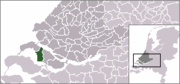
Goeree-Overflakkee
Encyclopedia

River delta
A delta is a landform that is formed at the mouth of a river where that river flows into an ocean, sea, estuary, lake, reservoir, flat arid area, or another river. Deltas are formed from the deposition of the sediment carried by the river as the flow leaves the mouth of the river...
island
Island
An island or isle is any piece of sub-continental land that is surrounded by water. Very small islands such as emergent land features on atolls can be called islets, cays or keys. An island in a river or lake may be called an eyot , or holm...
of the province
Province
A province is a territorial unit, almost always an administrative division, within a country or state.-Etymology:The English word "province" is attested since about 1330 and derives from the 13th-century Old French "province," which itself comes from the Latin word "provincia," which referred to...
of South Holland
South Holland
South Holland is a province situated on the North Sea in the western part of the Netherlands. The provincial capital is The Hague and its largest city is Rotterdam.South Holland is one of the most densely populated and industrialised areas in the world...
, Netherlands
Netherlands
The Netherlands is a constituent country of the Kingdom of the Netherlands, located mainly in North-West Europe and with several islands in the Caribbean. Mainland Netherlands borders the North Sea to the north and west, Belgium to the south, and Germany to the east, and shares maritime borders...
. It is separated from Voorne-Putten
Voorne-Putten
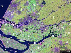
thumb|225px|right|Satellite image of the [[Rhine]]-[[Meuse river|Meuse]] [[river delta|delta]], showing the island of Voorne-Putten Voorne-Putten is an island between the North Sea, the Brielse meer and the rivers Oude Maas, Spui and Haringvliet in the province of South Holland in the Netherlands...
and Hoeksche Waard
Hoeksche Waard
thumb|right|[[Satellite]] [[image]] of the [[Rhine]]-[[Meuse river|Meuse]] [[river delta|delta]], showing the [[island]] of Hoekse Waard The Hoeksche Waard is an island between the Oude Maas, Dordtsche Kil, Hollands Diep, Haringvliet and Spui rivers in the province of Zuid Holland in the...
by the Haringvliet
Haringvliet
The Haringvliet is a large inlet of the North Sea, in the province of South Holland in the Netherlands. It is an important estuary of the Rhine-Meuse delta.Near Numansdorp, the Hollands Diep splits into the Haringvliet and the Volkerak estuaries...
, from the mainland of North Brabant
North Brabant
North Brabant , sometimes called Brabant, is a province of the Netherlands, located in the south of the country, bordered by Belgium in the south, the Meuse River in the north, Limburg in the east and Zeeland in the west.- History :...
by the Volkerak
Volkerak
The Volkerak is a body of water in the Netherlands. It is part of the Rhine–Meuse–Scheldt delta, and is situated between the island Goeree-Overflakkee to the north-west and the Dutch mainland to the south and east. The western part of the Volkerak is also called Krammer.Tributaries of the Volkerak...
, and from Schouwen-Duiveland
Schouwen-Duiveland
Schouwen-Duiveland is a municipality and an island in the southwestern Netherlands.The Brouwersdam is a dam, part of the Delta Works, from Schouwen-Duiveland to Goedereede, the west part of the island of Goeree-Overflakkee in South Holland....
by Lake Grevelingen
Grevelingen
Grevelingen or Grevelingenmeer is a former Rhine-Meuse estuary on the border of the Dutch provinces of South Holland and Zeeland that has become a lake due to the Delta Works....
.
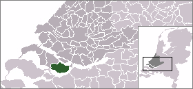
From west to east, it consists of the municipalities Goedereede
Goedereede
Goedereede is a municipality and a town in the western Netherlands, in the province of South Holland. The municipality had a population of 11408 in 2010, and covers an area of 153.85 km² of which 82.53 km² is water...
, Dirksland
Dirksland
Dirksland is a town and municipality on Goeree-Overflakkee Island in the western Netherlands, in the province of South Holland. The municipality had a population of 8,269 in 2004, and covers an area of 74.15 km² of which 18.59 km² is water.The municipality of Dirksland also includes...
, Middelharnis
Middelharnis
Middelharnis is a municipality and a village in the western Netherlands, in the province of South Holland. The municipality covers an area of 86.79 km² ....
, Oostflakkee
Oostflakkee
Oostflakkee is a municipality on the island of Goeree-Overflakkee in the western Netherlands, in the province of South Holland...
.
Despite being part of South Holland Province, the island's scenery and dialect is closer related to Zeeland
Zeeland
Zeeland , also called Zealand in English, is the westernmost province of the Netherlands. The province, located in the south-west of the country, consists of a number of islands and a strip bordering Belgium. Its capital is Middelburg. With a population of about 380,000, its area is about...
than to Holland.
Goedereede
This municipality consists of a number of towns. From west to east, they are Ouddorp (with Oostdijk), GoedereedeGoedereede
Goedereede is a municipality and a town in the western Netherlands, in the province of South Holland. The municipality had a population of 11408 in 2010, and covers an area of 153.85 km² of which 82.53 km² is water...
(with Havenhoofd) and Stellendam. Income consists mainly of tourism and fishery. Because of the extended and beautiful beach close by Ouddorp has a large number of camping grounds which is a big attraction for other inland Europeans, mainly Germans. Goedereede and Stellendam both have an extended fishing fleet.
Entering the town of Goedereede is like entering a different time. A town that takes you back a few centuries with its beautifully shaped buildings and tall church tower. Goedereede is one of two towns on the island that ever obtained city rights.
Stellendam was hit hard in the 1953 storm flood and several monuments in the town commemorate this tragic event. Next to Stellendam lies the Haringvlietdam which shelters the Haringvliet
Haringvliet
The Haringvliet is a large inlet of the North Sea, in the province of South Holland in the Netherlands. It is an important estuary of the Rhine-Meuse delta.Near Numansdorp, the Hollands Diep splits into the Haringvliet and the Volkerak estuaries...
from the North Sea, this dam is part of the Delta Project. On the island's side of the dam a 'Delta Expo' can be found with informative tours that guide you through the dam.
Dirksland
Melissant
Melissant is a village in the Dutch province of South Holland. It is located on the island Goeree-Overflakkee, in the municipality of Dirksland.Melissant was a separate municipality from 1817 until 1966, when it became part of Dirksland....
, Herkingen
Herkingen
Herkingen is a village in the Dutch province of South Holland. It is located on the south coast of the island Goeree-Overflakkee, in the municipality of Dirksland.Herkingen was a separate municipality between 1817 and 1966, when it merged with Dirksland....
and Dirksland
Dirksland
Dirksland is a town and municipality on Goeree-Overflakkee Island in the western Netherlands, in the province of South Holland. The municipality had a population of 8,269 in 2004, and covers an area of 74.15 km² of which 18.59 km² is water.The municipality of Dirksland also includes...
. The 1953 flood did not have such an enormous effect on these towns, because the lands they are on, lay generally higher than the rest of the island. Dirksland is the biggest of the three and also has the only hospital on the island. The Van Weel-Bethesda hospital is one the smallest in the country, but has an excellent reputation, coming out very high in national hospital grade polls. Dirksland is recognizable from a distance by the biggest watertower of the country! The towns are agriculturally focused and have several campgrounds for people who prefer a bit of rest over the busy Ouddorp area, but still want to be close to shore. Dirksland has an inland harbor with a newly restored gatecomplex. Herkingen lies on the south side of the island and borders the Grevelingenmeer. A saltwater lake that has been disconnected directly from the North Sea by the Brouwersdam, but still connects to the Oosterschelde which is saltwater. The Grevelingenmeer is a large watersports area with the main recreational areas on Schouwen-Duiveland. Herkingen is trying to join in with the tourism and has quite a large size yachting harbor. The town of Herkingen currently hosts several of the biggest modern windmills in the country.
Middelharnis

Sommelsdijk
Sommelsdijk is a village on the island Goeree-Overflakkee, South Holland, the Netherlands. Together with Nieuwe-Tonge, Middelharnis, and Stad aan 't Haringvliet, it is part of the municipality of Middelharnis. Other places nearby are Melissant, Ouddorp, and Dirksland...
, Middelharnis
Middelharnis
Middelharnis is a municipality and a village in the western Netherlands, in the province of South Holland. The municipality covers an area of 86.79 km² ....
, Nieuwe Tonge and Stad aan 't Haringvliet
Stad aan 't Haringvliet
Stad aan 't Haringvliet is a town in the Dutch province of South Holland. It is a part of the municipality of Middelharnis, and lies about 12 km southeast of Hellevoetsluis. The name means City on the Haringvliet...
are the towns that form this municipality. Middelharnis has a shopping area called D'n Diek. This shopping center settled itself on a dike which used to be the last barrier for the towns from the Haringvliet. Now extensive this dike and the area is enjoying a huge face lift. On Fridays in the summer months, there are what is called the Diekdagen (Diekdays in Dutch). These days there are special activities like sports car racing and bicycle racing in the middle of the town. The town hosts a public and Christian high school. Middelharnis has an inland harbor with connection to the Haringvliet. There is also a small beach which can get very crowded in the summertime. The old main street in both towns are very pretty. Starting at the church and ending at the harbor in both towns, they are very identical. In Middelharnis the old main street has the old municipality building. Both towns have the church in the center and the rest of the towns sort of vane out from this center. In Sommelsdijk a sportcomplex with swimming pool is present called De Staver.
Stad aan 't Haringvliet has a small harbor with beach. Like most of the towns on the island the old windmill has been preserved. Nieuwe Tonge's main entry roads are the two dikes that form the edges of the town. And of course a traditional windmill is present.
Oostflakkee
Ooltgensplaat, Achthuizen and Langstraat. Oude Tonge is the main town of this municipality with a considerable industrial area. It also has a large busstation. Oude Tonge suffered most in 1953 flood and was visited by the queen in 2003 to commemorate the 50 year anniversary of this event. Den Bommel is quite similar to Stad aan 't Haringvliet with a harbor and beach on the shores of the Haringvliet. A few kilometres east of Den Bommel there is Zuidzijde, a very small town with a neat looking water tower. Ooltgensplaat is the most eastward town on the island with a harbor on the Volkerak. The town has a very old and beautiful municipal building. This town has the yearly start and finish of De Omloop - a 100+ km walk around the island within a 24 hour period. This event attracts thousands every year either participants or those to watch the spectacle. It is held yearly in the latter half of August. Achthuizen and Langstraat are other small towns nearby Ooltgensplaat.
Gorée in Senegal
The island of GoréeGorée
Île de Gorée Île de Gorée Île de Gorée (i.e. "Gorée Island"; is one of the 19 communes d'arrondissement (i.e. "commune of arrondissement") of the city of Dakar, Senegal. It is a island located at sea from the main harbor of Dakar ....
in Senegal
Senegal
Senegal , officially the Republic of Senegal , is a country in western Africa. It owes its name to the Sénégal River that borders it to the east and north...
, notorious in the 18th Century as a center for the slave trade, got its name from the Dutch Goeree at the time when it was ruled by the Netherlands (from 1588 to 1664).