
Global Energy and Water Cycle Experiment
Encyclopedia
World Climate Research Programme
The World Climate Research Programme was established in 1980, under the joint sponsorship of International Council for Science and the World Meteorological Organization, and has also been sponsored by the Intergovernmental Oceanographic Commission of UNESCO since 1993. It is a component of the...
intended to observe, comprehend and models the Earth's water cycle
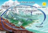
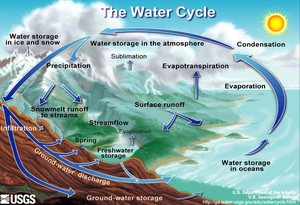
Water cycle
The water cycle, also known as the hydrologic cycle or H2O cycle, describes the continuous movement of water on, above and below the surface of the Earth. Water can change states among liquid, vapor, and solid at various places in the water cycle...
. The experiment also observes how much energy the Earth
Earth
Earth is the third planet from the Sun, and the densest and fifth-largest of the eight planets in the Solar System. It is also the largest of the Solar System's four terrestrial planets...
receives, studies how much of that energy reaches surfaces of the Earth and how that energy is transformed. Sunlight
Sunlight
Sunlight, in the broad sense, is the total frequency spectrum of electromagnetic radiation given off by the Sun. On Earth, sunlight is filtered through the Earth's atmosphere, and solar radiation is obvious as daylight when the Sun is above the horizon.When the direct solar radiation is not blocked...
's energy evaporates water to produce cloud
Cloud
A cloud is a visible mass of liquid droplets or frozen crystals made of water and/or various chemicals suspended in the atmosphere above the surface of a planetary body. They are also known as aerosols. Clouds in Earth's atmosphere are studied in the cloud physics branch of meteorology...
s and rain
Rain
Rain is liquid precipitation, as opposed to non-liquid kinds of precipitation such as snow, hail and sleet. Rain requires the presence of a thick layer of the atmosphere to have temperatures above the melting point of water near and above the Earth's surface...
, and dries out land masses after rain. Rain that falls on land becomes the water budget which can be used by people for agricultural and other processes.
GEWEX is a collaboration of researchers worldwide to find better ways of studying the water cycle and how it transforms energy through the atmosphere
Atmosphere
An atmosphere is a layer of gases that may surround a material body of sufficient mass, and that is held in place by the gravity of the body. An atmosphere may be retained for a longer duration, if the gravity is high and the atmosphere's temperature is low...
. If the Earth's climates were identical from year to year, then people could predict when, where and what crops to plant. However, instability created by solar variation, weather trends, and chaotic events create weather that is unpredictable on seasonal scales. Through weather patterns such as drought
Drought
A drought is an extended period of months or years when a region notes a deficiency in its water supply. Generally, this occurs when a region receives consistently below average precipitation. It can have a substantial impact on the ecosystem and agriculture of the affected region...
s and higher rainfall these cycles impact ecosystem
Ecosystem
An ecosystem is a biological environment consisting of all the organisms living in a particular area, as well as all the nonliving , physical components of the environment with which the organisms interact, such as air, soil, water and sunlight....
s and human activities. GEWEX is designed to collect a much greater amount of data, and see if better models of that data can forecast weather and climate change into the future.
GEWEX is organized into several structures. As GEWEX was conceived projects were organized by participating factions, this task is now done by the International GEWEX Project Office (IGPO). IGPO oversees major initiatives and coordinates between national projects in an effort to bring about communication of researchers. IGPO claims to support communication exchange between 2000 scientist and is the instrument for publication of major reports. The Scientific Steering Group organizes the projects and assigns them to panels, which oversee progress and provide critique. The Coordinated Energy and Water Cycle Observations Project (CEOP) the 'Hydrology Project' is a major instrument in GEWEX. This panel includes geographic study areas such as the Climate Prediction Program for the Americas operated by NOAA
National Oceanic and Atmospheric Administration
The National Oceanic and Atmospheric Administration , pronounced , like "noah", is a scientific agency within the United States Department of Commerce focused on the conditions of the oceans and the atmosphere...
, but also examines several types of climate zones (e.g. high altitude and semi-arid). Another panel, the GEWEX Radiation Panel oversees the coordinated use of satellites and ground based observation to better estimate energy and water fluxes. One recent result GEWEX's Radiation panel has assessed data on rainfall for the last 25 years and determined that that global rainfall is 2.61 mm/day with a small statistic
Statistic
A statistic is a single measure of some attribute of a sample . It is calculated by applying a function to the values of the items comprising the sample which are known together as a set of data.More formally, statistical theory defines a statistic as a function of a sample where the function...
al variation. While the study period is short, after 25 years of measurement regional trends are beginning to appear. The GEWEX Modeling and Prediction Panel takes current models and analyzes the models when climate forcing phenomena occur (global warming as an example of a 'climate forcing' event). GEWEX is now the core project of WCRP.
Goals and design
ACCURATE
ACCURATE was established in 2005 by a group of computer scientists, psychologists and policy experts to address problems with electronic voting...
data that is collected over many years, and the application of model
Computational model
A computational model is a mathematical model in computational science that requires extensive computational resources to study the behavior of a complex system by computer simulation. The system under study is often a complex nonlinear system for which simple, intuitive analytical solutions are...
s. GEWEX was conceived to respond to the need for observations of the Earth's radiation
Radiation
In physics, radiation is a process in which energetic particles or energetic waves travel through a medium or space. There are two distinct types of radiation; ionizing and non-ionizing...
budget and clouds. Many preexisting techniques were limited to observations taken from land and populated areas. This ignored the large amount of weather that occurs over the oceans and unpopulated regions, with key data missing from these areas. Since satellites orbiting the earth cover large areas in small time frames, they can better estimate climate where measurements are infrequently taken. GEWEX was initiated by World Climate Research Programme
World Climate Research Programme
The World Climate Research Programme was established in 1980, under the joint sponsorship of International Council for Science and the World Meteorological Organization, and has also been sponsored by the Intergovernmental Oceanographic Commission of UNESCO since 1993. It is a component of the...
(WCRP) to take advantage of environmental satellites such as TRMM, but now uses information from newer satellites as well as collections land based instruments, such as BSRN
Baseline Surface Radiation Network
Baseline Surface Radiation Network is a project of the World Climate Research Programme and the Global Energy and Water Cycle Experiment and as such is aimed detecting important changes in the Earth's radiation field at the Earth's surface which may be related to climate changes...
. These land based instruments can be used to verify information interpreted from satellite. GEWEX studies the long-term and regional changes in climate with a goal of predicting important seasonal weather patterns and climate changes that occurs over a few years.
EWLINE
|

Research goals
The research interest of GEWEX is to study fluxes of radiation at the Earth's surface, predict seasonal hydration levels of soils and develop accurate models of predicting energy and water budgets around the world. The project sets its goal as to improve, by an order of magnitude, the ability to model and therefore prediction hydration (rainfall and evaporation) patterns GEWEX is linked to other WCRP projects such as Stratospheric Processes and their Role in Climate (SPARC) Project, and the Climate and Cryosphere Project through WCRP. and thus shares information and goals with other WCRP projects. The goal becomes more important with the newer WCRP project, the Coordinated Observation and Prediction of the Earth System.Complexity of the experiment
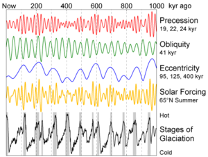
Aside from fluctuations of solar radiation, the sunlight that is transformed by the earth can vary greatly, some have concluded for instance, that ice-ages self-perpetuate once enough ice has accumulated in the polar regions to reflect enough radiation at high elevations to lower the global average temperature, whereas it takes an unusually warm period to reverse this state. Water usage by plants, herbivore activities can change albedo in the temperate and tropical zones. These trends in reflection are subject to change. Some have proposed extrapolating pre-GEWEX information using new information and measurements taken with pre-GEWEX technology. Natural fires, volcanism, and man-made aerosols can alter the amount of radiation reaching the earth. There are oscillations in oceanic currents, such as El-Niño and North Atlantic Oscillation which alter the parts of the earths ice mass and land water availability. The experiment takes a sampling of climate, with some of trends lasting a million years, and as paleo-climatology shows, can abruptly change.Therefore the ability to use data to predict change depends on factors that that are measurable over periods of time, factors that can affect global climate that abruptly appear can markedly alter the future. ]>_=148=_<[
Design
GEWEX is being implemented in phases. The first phase comprises information gathering, modeling, predictions, and advancement of observation techniques and is complete. The second phase addresses several scientific questions such as prediction capacity, changes in Earth's water cycle, and impact on water resources.First phase
Phase I (1990–2002), also called the "Build-Up Phase", was designed to determine the hydrological cycle and energy fluxes by means of global measurements of atmospheric and surface properties. GEWEX was also designed to model the global hydrological cycle and its impact on the atmosphere, oceans and land surfaces. Phase I processes were to develop the ability to predict the variations of global and regional hydrological processes & water resources, and their response to environmental change. It was also to advance the development of observing techniques, data management, and assimilation systems for operational application to long-range weather forecasts, hydrology, and climate predictions.During Phase I GEWEX projects were divided into the three overlapping sectors.
- GEWEX Radiation Panel (GRP) used satellite and ground based sensing over long periods to determine to delineate natural variation and climate changing forces.
- GEWEX Modelling and Prediction Panel (GMPP): Model the energy and water budget of the earth and determine the predictability. Apply modeling to determine climate forcing events, or respond to climate forcing events by analysis of predictions.
- GEWEX Hydrometeorology Panel (GHP) - Modeled and predicted changes in water cycle events on longer time scales (up to annual) using intensive regional studies to determine efficacy of data gathering and predictions. The Continental-Scale Experiments (CSEs) relied heavily on the following study areas that would eventually form the basis of the and the Coordinated Enhanced Observing Period (CEOP):
-
-
- Canada - Mackenzie river basin study area (MAGS) -completed
- United States - North American study area or GEWEX American Prediction Project(GAPP).
- Brazil - Large-Scale Biosphere Atmosphere Experiment in Amazonia (LBA)
- Scandinavia - Baltic Sea Experiment (BALTEX)
- Southern Africa - African Monsoon Multidisciplinary Analysis Project (AMMA)
- Indopacific and Asia - GEWEX Asian Monsoon Experiment (GAME) - completed in 2005
- Australia - Murray-Darling Basin Water Budget Project (MDB)
- But also:
- Continental-scale - International Project (GCIP)
- International Satellite Land-Surface Climatology Project (ISLSCP)
-
CEOP projects interacted with other non-GEWEX projects like CLIVAR and CLiC
Results
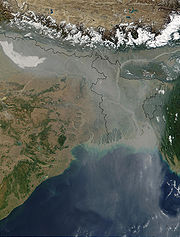
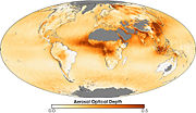
The results of the build-up phase include 15 to 25 years of study, measured the indirect effects of aerosol
Aerosol
Technically, an aerosol is a suspension of fine solid particles or liquid droplets in a gas. Examples are clouds, and air pollution such as smog and smoke. In general conversation, aerosol usually refers to an aerosol spray can or the output of such a can...
s, compiled a correlated data set, some reductions in uncertainty GEWEX claims the following accomplishments: A long period data set of cloud
Cloud
A cloud is a visible mass of liquid droplets or frozen crystals made of water and/or various chemicals suspended in the atmosphere above the surface of a planetary body. They are also known as aerosols. Clouds in Earth's atmosphere are studied in the cloud physics branch of meteorology...
s, rain fall
Precipitation (meteorology)
In meteorology, precipitation In meteorology, precipitation In meteorology, precipitation (also known as one of the classes of hydrometeors, which are atmospheric water phenomena is any product of the condensation of atmospheric water vapor that falls under gravity. The main forms of precipitation...
, water vapor
Water vapor
Water vapor or water vapour , also aqueous vapor, is the gas phase of water. It is one state of water within the hydrosphere. Water vapor can be produced from the evaporation or boiling of liquid water or from the sublimation of ice. Under typical atmospheric conditions, water vapor is continuously...
, surface radiation, and aerosols with no indication of large global trends, but with evidence of regional variability, models showing increased precipitation, and showed the importance of regional factors, such as water and soil conservation in regional climate change. The Phase I also claims to have produced over 200 publications and 15 review articles.
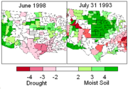
The Mississippi watershed was part of the GEWEX Continental scale International Projects and as a result was well situated for the analysis of the Great Flood of 1993 (Mississippi River
Mississippi River
The Mississippi River is the largest river system in North America. Flowing entirely in the United States, this river rises in western Minnesota and meanders slowly southwards for to the Mississippi River Delta at the Gulf of Mexico. With its many tributaries, the Mississippi's watershed drains...
and Red River
Red River Valley
The Red River Valley is a region in central North America that is drained by the Red River of the North. It is significant in the geography of North Dakota, Minnesota, and Manitoba for its relatively fertile lands and the population centers of Fargo, Moorhead, Grand Forks, and Winnipeg...
water sheds). The coordination between ground sensing observations and satellite information allowed more thorough analysis of events that led up to the flood. Researchers at the Center for Ocean-Land-Atmosphere Studies (COLA) found that upstream soil moisture and a multifold increase of moist
Humidity
Humidity is a term for the amount of water vapor in the air, and can refer to any one of several measurements of humidity. Formally, humid air is not "moist air" but a mixture of water vapor and other constituents of air, and humidity is defined in terms of the water content of this mixture,...
air flow from the Gulf of Mexico
Gulf of Mexico
The Gulf of Mexico is a partially landlocked ocean basin largely surrounded by the North American continent and the island of Cuba. It is bounded on the northeast, north and northwest by the Gulf Coast of the United States, on the southwest and south by Mexico, and on the southeast by Cuba. In...
to the flooded regions was a major factor in excessive rainfall. The Global Land/Atmosphere System Study (GLASS) gave GEWEX investigators the ability to observe soil wetness over much of the worlds surface by correlating observations on the ground with information obtained by satellites. While the ability to show cause is important, the different conditions (soil wetness, global patterns) that were permissive for weather anomalies are the focus of Phase I, gathering information and learning how to use satellite information better.
Sahel
The Sahel is the ecoclimatic and biogeographic zone of transition between the Sahara desert in the North and the Sudanian Savannas in the south.It stretches across the North African continent between the Atlantic Ocean and the Red Sea....
.
Critique
One critique of the Build-up Phase data and predictions is that there needs to be better error descriptions. The global estimate of rainfall indicates that the confidence range
Confidence interval
In statistics, a confidence interval is a particular kind of interval estimate of a population parameter and is used to indicate the reliability of an estimate. It is an observed interval , in principle different from sample to sample, that frequently includes the parameter of interest, if the...
is large relative to possible trend
Trend estimation
Trend estimation is a statistical technique to aid interpretation of data. When a series of measurements of a process are treated as a time series, trend estimation can be used to make and justify statements about tendencies in the data...
s. The number of ground sensing stations (currently around 40) in the BSRN is rather limited for global observation this affected the measurement of aerosols which are regionally dominant. The best measurements of aerosol pollution are obtained when cloud types are identified properly by satellite observation, therefore better cloud sensing strategies and models are need to provide the clearest real time data. Certain projects like GCIP allow have focused on continental scale observations provide better prediction for project areas, however areas outside these project areas may lag in receiving forecasting improvements. Many of the deficiencies in Phase I are improvement areas within the objectives of Phase II of the project. Currently scientist use NASA Aqua's Advanced Microwave Scanning Radiometer (AMSR-E) to evaluation soil moisture from space. However, except for focused observations the satellites data is not useful for global weather prediction. The proposed Soil Moisture and Ocean Salinity satellite
Soil Moisture and Ocean Salinity satellite
The Soil Moisture and Ocean Salinity Satellite is a part of ESA's Living Planet Programme intended to provide new insights into Earth's water cycle and climate...
would provide the detail of soil moisture information on a daily basis may provide the data needed for real time forecasting.
Second phase
Phase II, "Full Implementation" (2003–2012) of GEWEX is to "exploit new capabities" developed during phase I such as new satellite information and, increasingly, new models. These include changes in the Earth's energy budget and water cycle, contribution of processes in climate feedback, causes of natural variability, predicting changes on a seasonal or annual timescales, and how changes impact water resources. Phase II of is designed to be active models that have use to regional resource managers in real time. Some phases, such as the GAME (GEWEX Asia Monsoon Experiment) are already completed . GEWEX has become an umbrella program for the coordination of studies and experiments around the world. Reports from the phase I are still being produced and it will be some time before the results of the second phase are available. The experiment is still in progress.Panels
There are three panels in GEWEX: The Coordinated Energy and Water Cycle Observations Project(CEOP), GEWEX Radiation Panel(GRP), and GEWEX Modeling and Prediction Panel(GMPP)Coordinated Energy and Water Cycle Observations Project
The Coordinated Energy and Water Cycle Observations Project (CEOP) is the largest of the panel projects. There are several regional project areas most of these are now covered by CEOPAreas
For CEOP which survey the hydroclimate for southern African (AMMA), Baltic Sea area (BALTEX), North America (CPPA), Eastern Amazonia (LBA), La Plate Basin (LBB), Asia (MAHASRI), Australia (MDB), and Northern Eurasia (NEEPSI). In addition, CEOP coordinates the study of region types, such as cold, high altitude, monsoon, and semiarid climates and collects and formulates modeling on global, regional scale including land surface and surface hydrology modeling. Since GEWEX is an international cooperation it can utilize information from existing and planned satellites.Objectives
The COEP project has a number of energy budget and water cycle objectives. First is to produce more consistent research with better error definitions. Second is to better determine how energy flux and water cycles involve in feedback mechanisms. Third is to the predictability of important variables and improved parametric analysis to better model these processes. Forth, to colloborate with other hydrological science projects to create tools for assessing the water-system consequences of predictions and global climate change.GEWEX Radiation Panel
GEWEX Radiation panel (GRP) is a collaborative organization with a goal of reviewing theoretical and experimental knowledge of radiative processes within the climate system. Sixty percent of the energy that comes to Earth from the Sun is transformed by they earth. The goals of this collaboration is to determine how energy is transformed as it inevitably is radiated back into space.Global precipitation climatology project
GPCP task was to estimate precipitation using satellites that was global including places where people were not present to take measurements. Secondarily the project was tasked with studying regional precipitation on seasonal to between year time scales. As the study period of the project increased past 25 years a third objective was added analyze long-term variation, such as that caused by global warmingGlobal warming
Global warming refers to the rising average temperature of Earth's atmosphere and oceans and its projected continuation. In the last 100 years, Earth's average surface temperature increased by about with about two thirds of the increase occurring over just the last three decades...
. Also, in a renewed effort for better data and with more observation satellites, the GPCP, hopes to gain insights to rainfall variation on 'weather'-scale, or 4-hour periods to daily time scales.
Precipitation Assessment Group
The Precipitation Assessment Group was assigned by the panel to evaluate data on precipitation emphasizing data in the Global Precipitation Climatology Project (GPCP) product (GRP project). The GRP prepares to assimilate data from GPCP diurnal variation data for better estimation of the global precipitation products. The result of 25 years of measurement the global average precipitation rate is 2.61 mm per/day (about 0.1 inch/day) with about 1% uncertainty. The finding suggests there is no significant variation in mean annual rainfall. Regional variation was separated from land and ocean and the land variation of received precipitation was greater than the ocean. Satellites used to train the dataset analysis have the flaw of not having inaccurate measurements of drizzle and snow, and lack measurements in isolated places and over oceans. The rainfall maps show the greatest absolute rainfall error over the tropical oceans in regions with the highest estimated rainfall. The report self-critiques two aspects: the lack of polar-crossing satellites at the beginning of the study and the inability to correlate new information and older information (ground-based measurements). The noticeable trends in the dataset were deemed insignificant with regard to issues like global warming, but some stand-out positive trends over the Indopacific region were notable (Bay of Bengal and Indochina) and negative trends over South Central Africa
Africa
Africa is the world's second largest and second most populous continent, after Asia. At about 30.2 million km² including adjacent islands, it covers 6% of the Earth's total surface area and 20.4% of the total land area...
.
Surface Radiation Budget project
The SRB project under NASA/GEWEX took global radiation measurements to determine radiative energy fluxes. The energy that comes from the sun strikes the atmosphere and scatters, clouds and is reflected, the earth or water where heat and light are radiated back into the atmosphere or space. When water is struck heated surface water can evaporate carrying energy back into space through cloud formation and rain. The SRB project measured these processes by measuring fluxes at the Earths surface, top-of-atmosphere with shortwave (SW) and longwave (LW) radiation.Baseline Surface Radiation Network
At the onset of GEWEX there was inadequate information on how radiation redistributed, both horizontally and vertically.BSRN
Baseline Surface Radiation Network
Baseline Surface Radiation Network is a project of the World Climate Research Programme and the Global Energy and Water Cycle Experiment and as such is aimed detecting important changes in the Earth's radiation field at the Earth's surface which may be related to climate changes...
is a global system of less than 40 widely spread radiation measuring devices designed to measure changes in radiation at the earths surface. The information obtained is stored at the World Radiation Monitoring Center (WRMC) at the ETH (Zurich).
Global Aerosol Climatology Project
Established by Radiation Sciences Program(NASA) and GEWEX in 1998 to analyze satellite and field data to determine the distribution of aerosols, how they are formed, transformed and transported.GEWEX Modeling and Prediction Panel
The GEWEX modeling and prediction panel (GMPP) is charged with the task of finding better ways to use the data by other projects and other agencies. It oversees GEWEX Atmospheric Boundary Layer Study (GABLS), GEWEX Cloud System Study (GCSS), and Global Land/Atmosphere System Study(GLASS). Climate forcing is a process of study which observes the contribution of irregular events, such a volcano eruption, greenhouse warming, solar variation, fluctuations in the Earth's orbit, long term variation in the oceans circulation. The GMPP exploits these natural perturbations to test models developed that should predict what happens to global energy and water budgets with the perturbations.GEWEX Atmospheric Boundary Layer Study
GEWEX Atmospheric Boundary Layer Study (GABLS) is a more recent addition to GEWEX. The study is tasked with understanding the physical properties of the atmospheric boundary layers for better models which include representation of boundary layers.GEWEX Cloud System Study
GEWEX Cloud System Study (GCSS) task is to individualize modeling for different types of cloud systems. GCSS identifies 5 types of cloud systems:boundary layer, cirrus, extra tropical layer, precipitating convective, and polar. These cloud systems are generally too small to be rationalized in large scale climate modeling, this results in inadequate development of equations resulting in greater statistical uncertainty in results. In order to rationalize these process the study observes cloud systems at single fixed positions on earth in order to better estimate their parameters. These four areas are: Azores and Madeira Islands, Barbados, Equatorial Western Pacific, and Atlantic Tropics. The initial data collection is complete, methods developed for land and aircraft based observations can be compared with satellite observations to that better models of cloud system identification can be made at smaller scales.Global Land/Atmosphere System Study
Global Land/Atmosphere System Study(GLASS) tries to understand the impact on land surface parameters on atmosphere. Changes in land as a result of natural and man-made activities results in the ability to alter local climate and affect wind and cloud formation.Critique
The study period for GEWEX is 22 years, and while some climate oscillations are short, such as El-Nino, some climate oscillations last for decades, such as the North Atlantic Oscillation. Some have proposed extrapolating pre-GEWEX information using new information and measurements taken with pre-GEWEX technology. The MAGS project, located in Northwestern Canada utilized indigenous peoples traditional experiences. In addition, in other parts of the GEWEX study, these oscillations are an aspect of climate forcing, which allow testing of predictions and models. This modeling may be complicated by the fact that the North Atlantic Oscillation in switching state (see graph) as the effects of global warming are becoming more prominent. For example, 2006 and 2007 saw one of the most dramatic declines in Arctic Sea ice, a decline that was largely unpredicted and can shift the late summer albedo in the northern hemisphere. In 2008, sea ice extent decline has backed off from the previous years' trend, and researchers had forecast a strong La Nina event for late 2007 and 2008. However, unexpectedly the surface temperatures in the Eastern Pacific have already begun to rise to El-Nino temperature ranges, indicating the La Nina event may terminate unexpectedly. With this the loss of Northern Polar sea ice has begun to accelerate back toward the earlier trend. Such rapid and unexpected changes in climate-forcing events eventually suggest that modelers need to include parameters such as ocean temperature thermoclines, energy accumulation in the tropical oceans, sea ice extents in the polar regions, land glacial ice retraction in Greenland, and sheet ice and shelf ice remodeling in Antarctica. When multiple climate-forcing influences are acting simultaneously in which one of the events will eventually take dominance, lack of precedents from the past study of similar confluences of events, as well as knowledge of the uncertainty of sensitive 'switches' in the oceanic/atmospheric switches may affect the ability to provide accurate models and predictions. In addition, sampling points may be spread to monitor leading indicators in one common scenario may be useless during an oscillation where the pool of energy shifts to an unmonitored region so that the magnitude of the shift avoids computation.
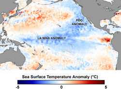
The extent and duration of the PDA are yet unpredictable, and its modulating effects on El-Nino/La-Nina patterns can only be speculated. These unknowns affect the ability for climate modelers to predict and indicate climate-forcing models need to accurate a wider sampling of data to be predictive.
Medieval Warm Period
The Medieval Warm Period , Medieval Climate Optimum, or Medieval Climatic Anomaly was a time of warm climate in the North Atlantic region, that may also have been related to other climate events around the world during that time, including in China, New Zealand, and other countries lasting from...
may have been a transition to an ice age, the last ice-age lasted from ~130,000 years ago until the onset of the Holocene. This ice-age may have been aborted by other factors including global warming. Such a stalling of long term cycles is believed to be a factor in the Dryas period, a warming interrupted by surface impacts of extraterrestrial origin may have occurred over hundreds of years. But the anthropogenic greenhouse effects and changing insolation patterns may have unpredictable long term effects. Reductions of glacial ice on land masses can cause isotatic rebounds, and may affect earthquakes and volcanism over a wide range. Rising sea levels can also affect patterns, and was seen in Indonesia, simply drilling a gas well in the wrong place may have touched off a mud volcano and there are some signs that this may precede a new caldera formation for a volcano. Over the very long term, the change in temperature of the earths crust on geothermal and volcanic processes is unknown. How this plays into climate-forcing events with magnitudes that are unpredictable is unknown.
The critiques at GEWEX can only be thrust at current results, which have added much more information about climate modeling that have created critiques, the major thrust of modeling was originally intended to be part of Phase II which will, after 4 years, produce its results. One of the major critiques of GEWEX phase I was land based measurements, which are now increasing. The other major critique is the inability to capture decadal rainfall events, events that frequently occur over a few hours. Therefore more measurements documenting shorter time frames may provide essential data for almost continuous data set. Therefore Phase II is mainly modeling with addition of more data as deemed lacking in Phase I. Many of the critiques above may be compensated for with better data requiring better models including insolation and changes in reflection. The problem with variation in ocean currents, particular with respect to thermocline depths requires more oceanography as part of the project, as with losses of ice and changes of climate on the ice edges.
External links
- Asian Monsoon Years 2007-2012
- The Hemispheric Observing System Research and Predictability Experiment
- Predictions in Ungauged Basins
- Monsoon Integrated Regional Studies
- GEWEX Soil Wetness Project 2
- International Satellite Cloud Climatology Project (ISCCPInternational Satellite Cloud Climatology ProjectThe International Satellite Cloud Climatology Project was established as the first project of the World Climate Research Program . Since its inception in 1982, there have been two phases, 1983–1995 and 1995–present. The project is responsible for collection and analysis of weather satellite...
) - Hydrometerological Array for ISV-monsoon Automonitoring
- Global Water System Project
- Global Energy and Water Cycle Experiment (GEWEX) Continental-Scale International Project:A Review of Progress and Opportunities - a free online book