
Glacial Lake Passaic
Encyclopedia
Glacial Lake Passaic was a prehistoric proglacial lake
that existed in northern New Jersey
in the United States
at the end of the last ice age
approximately 19,000-14,000 years ago. The lake was formed of waters released by the retreating Wisconsin Glacier, which had pushed large quantities of earth and rock ahead of its advance, blocking the previous natural drainage of the ancestral Passaic River
through a gap in the central Watchung Mountains
. The lake persisted for several thousand years as melting ice and eroding moraine dams slowly drained the former lake basin. The effect of the lake’s creation permanently altered the course of the Passaic River, forcing it to take a circuitous route through the northern Watchung Mountains before spilling out into the lower piedmont.
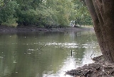
Today, the former lake basin is called Passaic Meadows and includes the Great Swamp
, Black Meadows, Troy Meadows
, Hatfield Swamp
, Lee Meadows
, Little Piece Meadows, Great Piece Meadows
, Glenhurst Meadows, and Bog and Vly Meadows. These remnants of the ancient lake provide prime wetland habitat to a variety of plants and animals while at the same time offering recreational and outdoor opportunities to residents of northern New Jersey.
. Cook’s first official mention of the lake was in the New Jersey Annual Report of the State Geologist for the Year 1880, in which he described flat-topped hills and drift-like deposits in the upper Passaic Valley that appeared to be created or modified by the waters of a lake. Twelve years later, field research conducted under State Geologist John C. Smock began to uncover wave-cut terraces and other shoreline features that more conclusively established the lake’s existence. However, the boundaries of the lake were not completely understood until the following year, 1893, when geologists Rollin D. Salisbury
and Henry B. Kümmel completed a study of wave cut terraces, shoreline platforms, and delta deposits within the central and upper Passaic basin. The study was used to create a report, Lake Passaic – An Extinct Glacial Lake, which was included in the New Jersey Annual Report of the State Geologist for the Year 1893.
and early Jurassic
periods, when the North American plate separated from the African plate, an aborted rift system was created. The resulting rift valley, known as the Newark Basin
, was filled with alternating layers of red bed sediment and flood basalts
. Over millions of years, the rift valley was faulted, tilted, and eroded, until the edges of the hard flood basalt layers formed ridges. Prior to 20,000 years before the present, an ancestral Passaic River flowed through a gap in these ridges. This changed when the Wisconsin Glacier
, a massive continental ice sheet which formed during the last ice age, advanced on the region and permanently plugged the gap. As the glacier eventually melted back, water pooled behind the ridges (known today as the Watchung Mountains), forming Glacial Lake Passaic.
/Short Hills Gap.
Previously, an ancestral Passaic River
flowed southeast toward Raritan Bay through the gap, but as the Hackensack lobe dammed it with ice, a lake began to form, reaching depths of nearly 200 feet. The resulting body of water formed the Chatham Stage, which initially found an outlet to the sea via the Blue Brook Valley, between the ridges of First and Second Watchung Mountain south of the Short Hills Gap. This outlet, however, was cut off as the Hackensack lobe continued to push south.
The Moggy Hollow Stage came to be the deepest stage of the ancient lake, reaching a depth of about 300 ft. Eventually, it came to cover the greatest area too. As the Wisconsin Glacier melted back, the lake’s waters ultimately submerged an area stretching from the base of Preakness Mountain
in Wayne
to the northern slope of Second Watchung Mountain in Liberty Corner
. During this time, it is believed that the ridges of Third Watchung Mountain formed a sinuous chain of islands running down the length of lake.
. In a short span of time, the level of the lake fell approximately 80 feet, the resulting drainage carving a spillway that would eventually become the valley of the Third River
.
The Great Notch Stage, as it came to be called, produced a lake of similar depth to the Chatham Stage, although covering a greater area. It is believed that Hook Mountain, one of the ridges of Third Watchung Mountain, was still an island at this time.
. The gap’s initial opening likely caused a flood which carved the valley of Weasel Brook, but the outflow eventually migrated further north, forming the course of the Passaic River as it exists today.
The release of water through the gap at Paterson saw the destruction of the last remaining ice dam holding back the lake. But topography and moraine deposits left in key chokepoints allowed the remains of the Great Notch Stage to split into three lakes of considerable size. These lakes would persist for another 3000 to 4000 years.
to Whippany
. The lake was held back by a dam of glacial sediment in Totowa
that slowly eroded until the surface of the lake fell to its present-day level, leaving behind the Hatfield Swamp, Black Meadows, Great Piece Meadows, and Bog and Vly Meadows.
) and Millington
, and was held back by moraine deposits. As with the Totowa stage, the lake’s earthen dam eroded away until the lake reached its modern level, forming Glenhurst Meadows.
crest of Long Hill. But even rock could not contain one of the last pieces of Glacial Lake Passaic. By about 14,000 years ago, water spilling through a gap in Long Hill carved the Millington Gorge, which lowered the level of the lake to form the present-day Great Swamp
.
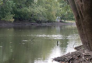 The remnants of the Glacial Lake Passaic lake bed are found in several swamps in northern New Jersey, most notably, the Great Swamp that is south of Morristown
through Chatham Township
, lying in extreme southern Morris County
and northeastern Somerset County
. The watershed of the Great Swamp entails fifty-five square miles. Within this watershed, Black Brook, Great Brook
, Loantaka Brook
, Primrose Brook, and the Upper Passaic River combine their waters in the Great Swamp to form the Passaic River, which exits the swamp via the Millington Gorge.
Following the largest American conservation effort by residents, a major portion of this watershed was acquired through assembling purchases made during a year-long effort that began in 1959. Those properties, entailing 7600 acres (30.8 km²) or just under twelve square miles, were preserved through a donation to the federal government on November 3, 1960, setting them aside as a park for perpetual protection. The area given to the government has since become the Great Swamp National Wildlife Refuge
and now is watched over by citizens from the ten communities that ring the swamp, who have formed thirteen separate oversight organizations. Additions to the area have continued to the present day.
rivers, has been severe enough to lead to government buyouts of private land. This section of the basin, upstream of the chokepoint created by the Little Falls and the Great Falls, occasionally fills with so much water that some of the Totowa Stage of Glacial Lake Passaic briefly reappears until enough time has gone by for the water to drain out. The Passaic River Flood Tunnel
, a floodwater diversion system, has been proposed to create a new escape route for water trapped behind the Watchung Mountains.
Proglacial lake
In geology, a proglacial lake is a lake formed either by the damming action of a moraine or ice dam during the retreat of a melting glacier, or by meltwater trapped against an ice sheet due to isostatic depression of the crust around the ice...
that existed in northern New Jersey
New Jersey
New Jersey is a state in the Northeastern and Middle Atlantic regions of the United States. , its population was 8,791,894. It is bordered on the north and east by the state of New York, on the southeast and south by the Atlantic Ocean, on the west by Pennsylvania and on the southwest by Delaware...
in the United States
United States
The United States of America is a federal constitutional republic comprising fifty states and a federal district...
at the end of the last ice age
Ice age
An ice age or, more precisely, glacial age, is a generic geological period of long-term reduction in the temperature of the Earth's surface and atmosphere, resulting in the presence or expansion of continental ice sheets, polar ice sheets and alpine glaciers...
approximately 19,000-14,000 years ago. The lake was formed of waters released by the retreating Wisconsin Glacier, which had pushed large quantities of earth and rock ahead of its advance, blocking the previous natural drainage of the ancestral Passaic River
Passaic River
The Passaic River is a mature surface river, approximately 80 mi long, in northern New Jersey in the United States. The river in its upper course flows in a highly circuitous route, meandering through the swamp lowlands between the ridge hills of rural and suburban northern New Jersey,...
through a gap in the central Watchung Mountains
Watchung Mountains
The Watchung Mountains are a group of three long low ridges of volcanic origin, between 400 ft. and 500 ft. high, lying parallel to each other in northern New Jersey in the United States...
. The lake persisted for several thousand years as melting ice and eroding moraine dams slowly drained the former lake basin. The effect of the lake’s creation permanently altered the course of the Passaic River, forcing it to take a circuitous route through the northern Watchung Mountains before spilling out into the lower piedmont.
Today, the former lake basin is called Passaic Meadows and includes the Great Swamp
Great Swamp National Wildlife Refuge
The Great Swamp National Wildlife Refuge is located in Morris County, New Jersey. Established in 1960, it is one of more than 550 refuges in the National Wildlife Refuge System.The refuge was declared a National Natural Landmark in May 1966...
, Black Meadows, Troy Meadows
Troy Meadows
Troy Meadows is a nature preserve in Parsippany-Troy Hills, Morris County, New Jersey. Along with the Great Swamp, it is one of the remnants of Glacial Lake Passaic. It was designated a National Natural Landmark in 1967...
, Hatfield Swamp
Hatfield Swamp
Hatfield Swamp is a fresh water wetland area in the US state of New Jersey, forming what might be considered the "second bank" of the Passaic River between Morris and Essex counties.-Geology:...
, Lee Meadows
Lee Meadows Swamp
The Lee Meadows Swamp in eastern Morris County of New Jersey in the United States was originally a swamp with low woodlands surrounding it. It is located in the southeastern section of Parsippany-Troy Hills Township and the western section of Hanover Township, in Morris County, New Jersey...
, Little Piece Meadows, Great Piece Meadows
Great Piece Meadows
Great Piece Meadows is a fresh water swamp located in Morris and Essex Counties, New Jersey. The wooded swamp is mostly inside the bow of the Passaic River which floods during the year from heavy rain or heavy snow melt.-Geology:...
, Glenhurst Meadows, and Bog and Vly Meadows. These remnants of the ancient lake provide prime wetland habitat to a variety of plants and animals while at the same time offering recreational and outdoor opportunities to residents of northern New Jersey.
Discovery
The discovery of Glacial Lake Passaic is credited to Professor George Hammell Cook, once the State Geologist of New Jersey and Vice President of Rutgers UniversityRutgers University
Rutgers, The State University of New Jersey , is the largest institution for higher education in New Jersey, United States. It was originally chartered as Queen's College in 1766. It is the eighth-oldest college in the United States and one of the nine Colonial colleges founded before the American...
. Cook’s first official mention of the lake was in the New Jersey Annual Report of the State Geologist for the Year 1880, in which he described flat-topped hills and drift-like deposits in the upper Passaic Valley that appeared to be created or modified by the waters of a lake. Twelve years later, field research conducted under State Geologist John C. Smock began to uncover wave-cut terraces and other shoreline features that more conclusively established the lake’s existence. However, the boundaries of the lake were not completely understood until the following year, 1893, when geologists Rollin D. Salisbury
Rollin D. Salisbury
Rollin Daniel Salisbury was an American geologist and educator.-Biography:Salisbury was born at Spring Prairie, Wisconsin in 1858. He studied at Whitewater State Normal School in Whitewater, Wisconsin, graduating in 1877 after completing the four-year course in just two-and-one-half years...
and Henry B. Kümmel completed a study of wave cut terraces, shoreline platforms, and delta deposits within the central and upper Passaic basin. The study was used to create a report, Lake Passaic – An Extinct Glacial Lake, which was included in the New Jersey Annual Report of the State Geologist for the Year 1893.
Geology
During the late TriassicTriassic
The Triassic is a geologic period and system that extends from about 250 to 200 Mya . As the first period of the Mesozoic Era, the Triassic follows the Permian and is followed by the Jurassic. Both the start and end of the Triassic are marked by major extinction events...
and early Jurassic
Jurassic
The Jurassic is a geologic period and system that extends from about Mya to Mya, that is, from the end of the Triassic to the beginning of the Cretaceous. The Jurassic constitutes the middle period of the Mesozoic era, also known as the age of reptiles. The start of the period is marked by...
periods, when the North American plate separated from the African plate, an aborted rift system was created. The resulting rift valley, known as the Newark Basin
Newark Basin
The Newark Basin is a sediment-filled rift basin located mainly in northern New Jersey but also stretching into south-eastern Pennsylvania and southern New York. It is part of the system of Eastern North America Rift Basins.-Geology:...
, was filled with alternating layers of red bed sediment and flood basalts
Flood basalt
A flood basalt or trap basalt is the result of a giant volcanic eruption or series of eruptions that coats large stretches of land or the ocean floor with basalt lava. Flood basalts have occurred on continental scales in prehistory, creating great plateaus and mountain ranges...
. Over millions of years, the rift valley was faulted, tilted, and eroded, until the edges of the hard flood basalt layers formed ridges. Prior to 20,000 years before the present, an ancestral Passaic River flowed through a gap in these ridges. This changed when the Wisconsin Glacier
Wisconsin glaciation
The last glacial period was the most recent glacial period within the current ice age occurring during the last years of the Pleistocene, from approximately 110,000 to 10,000 years ago....
, a massive continental ice sheet which formed during the last ice age, advanced on the region and permanently plugged the gap. As the glacier eventually melted back, water pooled behind the ridges (known today as the Watchung Mountains), forming Glacial Lake Passaic.
Lake Stages
Glacial Lake Passaic was a dynamic water body during its five millennia of existence. At present, the lake is believed to have existed in four major stages, the final stage being split between three smaller sub-stages. Each stage saw a new shoreline elevation of the lake as ice or earthen moraine dams were built or gave way, often over brief spans of time.Chatham Stage
Approximately 20,000 years ago, the Wisconsin Glacier advanced across northern New Jersey, expanding differentially across the land as it encountered variable terrain. West of the Watchung Mountains and east of the Appalachians, the Passaic lobe of the great glacier was impeded by rugged terrain, slowing its southward advance. East of the Watchung Mountains, the Hackensack lobe of the glacier spread more easily over the piedmont lowlands, advancing on the HobartHobart Gap
The Hobart Gap is a strategic pass and road through the Watchung Mountains in Northern New Jersey. The confluence of the two branches of the Rahway River is located here...
/Short Hills Gap.
Previously, an ancestral Passaic River
Passaic River
The Passaic River is a mature surface river, approximately 80 mi long, in northern New Jersey in the United States. The river in its upper course flows in a highly circuitous route, meandering through the swamp lowlands between the ridge hills of rural and suburban northern New Jersey,...
flowed southeast toward Raritan Bay through the gap, but as the Hackensack lobe dammed it with ice, a lake began to form, reaching depths of nearly 200 feet. The resulting body of water formed the Chatham Stage, which initially found an outlet to the sea via the Blue Brook Valley, between the ridges of First and Second Watchung Mountain south of the Short Hills Gap. This outlet, however, was cut off as the Hackensack lobe continued to push south.
Moggy Hollow Stage
The Hackensack lobe of the Wisconsin Glacier piled a massive moraine into the Short Hills Gap and northern Blue Brook Valley, effectively creating a permanent dam even after the ice began retreating to the north. With its outlet to the sea severed, Glacial Lake Passaic rose until it found a new escape point via a gap in the southwestern Watchung Mountains known as Moggy Hollow.The Moggy Hollow Stage came to be the deepest stage of the ancient lake, reaching a depth of about 300 ft. Eventually, it came to cover the greatest area too. As the Wisconsin Glacier melted back, the lake’s waters ultimately submerged an area stretching from the base of Preakness Mountain
Preakness Range
The Preakness Range is a range of the trap rock Watchung Mountains on the western edge of the Newark Basin in northern New Jersey. A large portion of this range is included in High Mountain Park Preserve, offering miles of hiking trails with vistas overlooking New Jersey and New York City...
in Wayne
Wayne, New Jersey
Wayne is a Township in Passaic County, New Jersey, United States, located less than from midtown Manhattan. As of the United States 2000 Census, the township had a total population of 54,069....
to the northern slope of Second Watchung Mountain in Liberty Corner
Liberty Corner, New Jersey
Liberty Corner is an unincorporated community in Bernards Township, Somerset County, New Jersey, United States. Liberty Corner is about 3.75 miles south of Bernardsville. Liberty Corner has a post office with ZIP code 07938.-Geography:...
. During this time, it is believed that the ridges of Third Watchung Mountain formed a sinuous chain of islands running down the length of lake.
Great Notch Stage
The first major drop in the level of Glacial Lake Passaic occurred as the Wisconsin Glacier melted back to reveal the Great Notch, a significant gap present in the ridge of First Watchung Mountain in CliftonClifton, New Jersey
Clifton is a city in Passaic County, New Jersey, United States. As of the 2010 United States Census, the city had a total population of 84,136. The 2010 population represented an increase of 5,464 residents from its population of 78,672 in the 2000 Census, making it the state's 11th largest...
. In a short span of time, the level of the lake fell approximately 80 feet, the resulting drainage carving a spillway that would eventually become the valley of the Third River
Third River (New Jersey)
The Third River is the third main tributary of the Passaic River in the northern portion of the U.S. state of New Jersey. It has also been known as the Yantecaw River....
.
The Great Notch Stage, as it came to be called, produced a lake of similar depth to the Chatham Stage, although covering a greater area. It is believed that Hook Mountain, one of the ridges of Third Watchung Mountain, was still an island at this time.
Postglacial Stages
The Great Notch Stage came to an end as the Wisconsin Glacier withered to reveal a gap in First Watchung Mountain in PatersonPaterson, New Jersey
Paterson is a city serving as the county seat of Passaic County, New Jersey, United States. As of the 2010 United States Census, its population was 146,199, rendering it New Jersey's third largest city and one of the largest cities in the New York City Metropolitan Area, despite a decrease of 3,023...
. The gap’s initial opening likely caused a flood which carved the valley of Weasel Brook, but the outflow eventually migrated further north, forming the course of the Passaic River as it exists today.
The release of water through the gap at Paterson saw the destruction of the last remaining ice dam holding back the lake. But topography and moraine deposits left in key chokepoints allowed the remains of the Great Notch Stage to split into three lakes of considerable size. These lakes would persist for another 3000 to 4000 years.
Totowa Stage
The Totowa Stage was most northern of the three postglacial lakes, occupying an irregular basin extending from OaklandOakland, New Jersey
Oakland is a borough in Bergen County, New Jersey, United States. As of the 2010 United States Census, the borough population was 12,754.Oakland was incorporated as a borough by an Act of the New Jersey Legislature on April 8, 1902, from portions of Franklin Township.-History:The Van Allen House...
to Whippany
Whippany, New Jersey
Whippany is an unincorporated area located within Hanover Township in Morris County, New Jersey. Whippany's name is derived from the Whippanong Native Americans, a tribe that once inhabited the area...
. The lake was held back by a dam of glacial sediment in Totowa
Totowa, New Jersey
Totowa is a borough in Passaic County, New Jersey, United States. As of the 2000 United States Census, the borough population was 9,892.Totowa was formed as a borough by an Act of the New Jersey Legislature on March 15, 1898, from portions of the now-defunct Manchester Township and Wayne...
that slowly eroded until the surface of the lake fell to its present-day level, leaving behind the Hatfield Swamp, Black Meadows, Great Piece Meadows, and Bog and Vly Meadows.
Stanley Stage
Upstream of the Totowa Stage, and lying between Second and Third Watchung Mountain, was the Stanley Stage. The lake occupied an area between Stanley (near SummitSummit, New Jersey
Summit is a city in Union County, New Jersey, United States. At the 2010 United States Census, the city's population was 21,457. Summit had the 16th-highest per capita income in the state as of the 2000 Census....
) and Millington
Millington, New Jersey
Millington is an unincorporated area within Long Hill Township in Morris County, New Jersey, United States. The area is served as United States Postal Service ZIP Code 07946. As of the United States Census, 2000, the population for ZIP Code Tabulation Area 07946 was 3,000...
, and was held back by moraine deposits. As with the Totowa stage, the lake’s earthen dam eroded away until the lake reached its modern level, forming Glenhurst Meadows.
Millington Stage
The most upstream of three lakes, the Millington Stage was probably 50 feet deep at maximum, occupying the basin west of Long Hill, the southernmost ridge of Third Watchung Mountain. Unlike the other two lakes, the Millington Stage drained over the trap rockTrap rock
Trap rock is a form of igneous rock that tends to form polygonal vertical fractures, most typically hexagonal, but also four to eight sided. The fracture pattern forms when magma of suitable chemical composition intrudes as a sill or extrudes as a thick lava flow, and slowly cools.Because of the...
crest of Long Hill. But even rock could not contain one of the last pieces of Glacial Lake Passaic. By about 14,000 years ago, water spilling through a gap in Long Hill carved the Millington Gorge, which lowered the level of the lake to form the present-day Great Swamp
Great Swamp
Great Swamp may refer to:* United States:** Great Swamp, New Jersey see Great Swamp National Wildlife Refuge and Glacial Lake Passaic until an article is created that features the entire swamp and its nature** Great Swamp...
.
Conservation
Morristown, New Jersey
Morristown is a town in Morris County, New Jersey, United States. As of the 2010 United States Census, the town population was 18,411. It is the county seat of Morris County. Morristown became characterized as "the military capital of the American Revolution" because of its strategic role in the...
through Chatham Township
Chatham Township, New Jersey
Chatham Township is a township in Morris County, New Jersey, United States. As of the 2010 United States Census, the population was 10,452.Chatham Township was incorporated by an Act of the New Jersey Legislature on February 12, 1806, from portions of Hanover Township and Morris Township, based on...
, lying in extreme southern Morris County
Morris County, New Jersey
Morris County is a county located in the U.S. state of New Jersey, about west of New York City. According to the United States 2010 Census, the population was 492,276. It is part of the New York Metropolitan Area. Its county seat is Morristown....
and northeastern Somerset County
Somerset County, New Jersey
Somerset County is a county located in the U.S. state of New Jersey. In 2010, the population was 323,444. It is part of the New York Metropolitan Area. Its county seat is Somerville....
. The watershed of the Great Swamp entails fifty-five square miles. Within this watershed, Black Brook, Great Brook
Great Brook (New Jersey)
Great Brook is a tributary of the Passaic River which passes through Bernardsville, New Jersey.-See also:* List of New Jersey rivers...
, Loantaka Brook
Loantaka Brook
Loantaka Brook is a tributary of the Passaic River in New Jersey in the United States.The main headwaters of Loantaka Brook arise in Morris Township between Route 124 and Woodland Avenue in the area just below the medical office parks on the south side of Madison Avenue...
, Primrose Brook, and the Upper Passaic River combine their waters in the Great Swamp to form the Passaic River, which exits the swamp via the Millington Gorge.
Following the largest American conservation effort by residents, a major portion of this watershed was acquired through assembling purchases made during a year-long effort that began in 1959. Those properties, entailing 7600 acres (30.8 km²) or just under twelve square miles, were preserved through a donation to the federal government on November 3, 1960, setting them aside as a park for perpetual protection. The area given to the government has since become the Great Swamp National Wildlife Refuge
Great Swamp National Wildlife Refuge
The Great Swamp National Wildlife Refuge is located in Morris County, New Jersey. Established in 1960, it is one of more than 550 refuges in the National Wildlife Refuge System.The refuge was declared a National Natural Landmark in May 1966...
and now is watched over by citizens from the ten communities that ring the swamp, who have formed thirteen separate oversight organizations. Additions to the area have continued to the present day.
Flooding
Chronic flooding in the central Passaic basin, particularly around the confluence of the Passaic and PomptonPompton River
The Pompton River is a tributary of the Passaic River, approximately 8 mi long, in northern New Jersey in the United States....
rivers, has been severe enough to lead to government buyouts of private land. This section of the basin, upstream of the chokepoint created by the Little Falls and the Great Falls, occasionally fills with so much water that some of the Totowa Stage of Glacial Lake Passaic briefly reappears until enough time has gone by for the water to drain out. The Passaic River Flood Tunnel
Passaic River Flood Tunnel
The Passaic River Flood Tunnel is a proposal for a flood relief tunnel from the central portion of the Passaic River basin in Passaic County, New Jersey in an area where a number of large tributary rivers join the Passaic River and severe flooding occasionally occurs...
, a floodwater diversion system, has been proposed to create a new escape route for water trapped behind the Watchung Mountains.
See also
- Glacial Lake Hackensack, which existed a few miles east of Glacial Lake Passaic.
- List of prehistoric lakes