
Ghanzi District
Encyclopedia
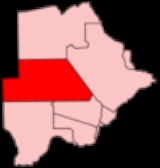
Ghanzi is a district
in western Botswana
, bordering Namibia
in the west and extending east into much of the interior of the country. The district's administrative centre is the town of Ghanzi
. Most of the eastern half of Ghanzi makes up the Central Kalahari Game Reserve
. The human population at the 2001 census was 33,170, less populous than that of any other district in Botswana. Ghanzi's area is 117,910 km².
Region of Namibia
. Domestically, it borders the following districts:
Ghanzi is traversed by the northwesterly line of equal latitude and longitude.
with a population of 9,934 according to the 2001 census, which is five times more than the second-largest village Ncojane has. The following is the list of the villages in Ghanzi district listed separately in 2001 census:
, some of which is also covered by the Makgadikgadi Pans, a large seasonal wetland. The Makgadigadi was one of the Earth's largest lakes during the Pleistocene
, but currently provides a vast summer wetland to support tens of thousands of migrating flamingo
s in the rainy summer season.
Districts of Botswana
||Botswana is divided into 16 administrative districts: 10 rural districts and 6 urban districts. These are administered by 16 local authorities...
in western Botswana
Botswana
Botswana, officially the Republic of Botswana , is a landlocked country located in Southern Africa. The citizens are referred to as "Batswana" . Formerly the British protectorate of Bechuanaland, Botswana adopted its new name after becoming independent within the Commonwealth on 30 September 1966...
, bordering Namibia
Namibia
Namibia, officially the Republic of Namibia , is a country in southern Africa whose western border is the Atlantic Ocean. It shares land borders with Angola and Zambia to the north, Botswana to the east and South Africa to the south and east. It gained independence from South Africa on 21 March...
in the west and extending east into much of the interior of the country. The district's administrative centre is the town of Ghanzi
Ghanzi
Ghanzi is a town in the western part of the Republic of Botswana in southern Africa. At the time of the 2001 census, there were 9,934 people living in the town with another 861 nearby. It is the administrative center of Ghanzi District and is known as the "Capital of the Kalahari"...
. Most of the eastern half of Ghanzi makes up the Central Kalahari Game Reserve
Central Kalahari Game Reserve
Central Kalahari Game Reserve is an extensive national park in the Kalahari desert of Botswana. Established in 1961 it covers an area of 52,800 km² making it the second largest game reserve in the world.The park contains wildlife such as giraffe, brown hyena, warthog, cheetah, wild dog,...
. The human population at the 2001 census was 33,170, less populous than that of any other district in Botswana. Ghanzi's area is 117,910 km².
Location
In the west, Ghanzi borders the OmahekeOmaheke
Omaheke is one of the thirteen regions of Namibia. Omaheke lies on the eastern border of Namibia and is the Western extension of the Kalahari desert. The name Omaheke is the Herero word for Sandveld. A large part of this region is known as the Sandveld...
Region of Namibia
Namibia
Namibia, officially the Republic of Namibia , is a country in southern Africa whose western border is the Atlantic Ocean. It shares land borders with Angola and Zambia to the north, Botswana to the east and South Africa to the south and east. It gained independence from South Africa on 21 March...
. Domestically, it borders the following districts:
- North-WestNorth-West District (Botswana)North-West District Council is one of the local authorities of Botswana. It was established in 1966, overlapping the administrative districts of Chobe and Ngamiland...
- north - CentralCentral District (Botswana)Central is the largest of Botswana's districts in terms of area and population. It encompasses the traditional homeland of the Bamangwato people. Some of the most politically connected Batswana have come from the Central District, including former President Sir Seretse Khama, former President...
- east - KwenengKweneng DistrictKweneng is one of the districts of Botswana and is the recent historical homeland of the Bakwena people, the first group in Botswana converted to Christianity by famed missionary David Livingstone. Various landmarks, including Livingstone's Cave, allude to this history...
- southeast - KgalagadiKgalagadiKgalagadi is a district in southwest Botswana, lying along the country's border with Namibia and South Africa. The administrative center is Tshabong. Kgalagadi covers a vast area of the Kalahari Desert. It has a total area of 105,200 km², and has a population of only 42,000...
- south
Ghanzi is traversed by the northwesterly line of equal latitude and longitude.
Settlements
The largest village in the district is the capital GhanziGhanzi
Ghanzi is a town in the western part of the Republic of Botswana in southern Africa. At the time of the 2001 census, there were 9,934 people living in the town with another 861 nearby. It is the administrative center of Ghanzi District and is known as the "Capital of the Kalahari"...
with a population of 9,934 according to the 2001 census, which is five times more than the second-largest village Ncojane has. The following is the list of the villages in Ghanzi district listed separately in 2001 census:
- BereBere, BotswanaBere is a village in Ghanzi District of Botswana. It is located in the southern part of the district, and it has a primary school. The population was 385 in 2001 census. Bere is now one of the few places in the Central Kalahari where Persistence hunting is still practised.-References:...
, Charles HillCharles Hill, BotswanaCharles Hill is a village in Ghanzi District of Botswana. It is located close to be Namibian border. Charles Hill is the second-largest settlement in Ghanzi District, with a population of 1,859 in 2001 census....
, ChobokwaneChobokwaneChobokwane is a village in Ghanzi District of Botswana. It is located south-west of the district capital Ghanzi, and has a primary school. The population was 484 in 2001 census.-References:...
, DekarDekarD'Kar is a village in Ghanzi District of Botswana. It is located 40 km to the east of the district capital, Ghanzi. The population was 943 in 2001 census. It was first a farm of someone, but then evolved into a rural village, most of the village is owned by the church, but this village also houses...
, East HanahaiEast HanahaiEast Hanahai is a village in Ghanzi District of Botswana. It is located located in the central part of the district, close to the Central Kalahari Game Reserve, roughly 50km south-east of Ghanzi. East Hanahai has a primary school and a health clinic...
, GhanziGhanziGhanzi is a town in the western part of the Republic of Botswana in southern Africa. At the time of the 2001 census, there were 9,934 people living in the town with another 861 nearby. It is the administrative center of Ghanzi District and is known as the "Capital of the Kalahari"...
, Groote LaagteGroote LaagteGroote Laagte is a village in Ghanzi District of Botswana. It is located close to the Namibian border, north-west of the district capital Ghanzi. Groote Laagte has a primary school and the population was 483 in 2001 census.-References:...
, KacgaeKacgaeKacgae is a village in Ghanzi District of Botswana. It is located in the southern part of the district, and it has a primary school. The population was 282 in 2001 census.-References:...
, KarakobisKarakobisKarakobis is a village in Ghanzi District of Botswana. It is located close to the Namibian border. The population was 785 in 2001 census.-References:...
, KuleKuleKule is a village in Ghanzi District of Botswana. It is located close to the border with Namibia and has a primary school, clinic, customary court, social and development offices, animal health and production and police offices. The population was 741 in 2001 census.-References:...
, MakundaMakundaMakunda is a village in Ghanzi District of Botswana. It is located close to the Namibian border. The population was 331 in 2001 census.-References:...
, Ncojane, New XadeNew XadeNew Xade is a village located in the central part of the Ghanzi District of Botswana. The population was 930 in 2001 census.-A Relocation Settlement:...
, New XanagasNew XanagasNew Xanagas is a village in Ghanzi District of Botswana. It is located western part of the district. New Xanagas has a primary school and the population was 540 in 2001 census.-References:...
, QaboQaboQabo is a village in Ghanzi District of Botswana. It is located in the north-eastern part of the district, north of the district capital Ghanzi, and it has a primary school. The population was 401 in 2001 census.-References:...
, TsootshaTsootshaTsootsha is a village in Ghanzi District of Botswana. It is located close to the border with Namibia. The population was 1,397 in 2001 census.-References:...
, West HanahaiWest HanahaiWest Hanahai is a village in Ghanzi District of Botswana. It is located in the central part of the district, close to the Central Kalahari Game Reserve roughly 50km south west of Ghanzi...
Natural features
This region is largely covered by the Kalahari DesertKalahari Desert
The Kalahari Desert is a large semi-arid sandy savannah in Southern Africa extending , covering much of Botswana and parts of Namibia and South Africa, as semi-desert, with huge tracts of excellent grazing after good rains. The Kalahari supports more animals and plants than a true desert...
, some of which is also covered by the Makgadikgadi Pans, a large seasonal wetland. The Makgadigadi was one of the Earth's largest lakes during the Pleistocene
Pleistocene
The Pleistocene is the epoch from 2,588,000 to 11,700 years BP that spans the world's recent period of repeated glaciations. The name pleistocene is derived from the Greek and ....
, but currently provides a vast summer wetland to support tens of thousands of migrating flamingo
Flamingo
Flamingos or flamingoes are gregarious wading birds in the genus Phoenicopterus , the only genus in the family Phoenicopteridae...
s in the rainy summer season.