

Getafe
Encyclopedia
Getafe is a city in the southern zone of the Madrid metropolitan area
, Spain
, and one of the most populated and industrialized cities in the municipality. The city is home to one of the oldest Spanish military
air bases, as well as the Universidad Carlos III de Madrid
. Also located within the city is the Cerro de los Ángeles
, or Hill of the Angels, a site considered to be the geographical center of the Iberian Peninsula
. The city is located 13 km south of Madrid's city centre, within the metro area
. It is situated within a flat area of Spain's Meseta Central in the Manzanares River basin.
Getafe's proximity to Madrid fostered industrial development during the 20th and 21st centuries. The industrialization of Getafe led to an increase in population to 159,300 (as of December 2007). Due to its industrial and social networks, the majority of residents work or study within the city, transforming it into a commuter town
. The increase in population led to the construction of numerous access roads, an increase in available public services, and the creation of new neighborhoods at the end of the 20th century.
, a number of villages were located in the present-day area of Getafe. One of the main villages was Alarnes, which was very close to the current urban center. In 1326, the villagers united themselves into one city, situated on the royal road that linked Madrid with Toledo
. This new city was called Xatafi, a name which came from the Arab word jata ("something long"). It is assumed that the name Xatafi referred to the royal road, which also served as the town's main street. The city's name evolved over time, from Xetafe to Jetafee to Jetaphe to Jetafe to Getafe.
period (before 100,000 BCE). Various stone tools, pots, and bracelets from this period have been excavated from the banks of the Manzanares River.
The Romans dominated the Iberian Peninsula from the 2nd century BCE until the 5th century. In the 3rd century, the Romans constructed a villa called La Torecilla, whose ruins are still visible on the banks of the Manzanares River. The area was subsequently overrun by a series of Germanic tribes, including Suebi
, Vandals
and Visigoths, and the Indoeuropean Alans
.
The area currently encompassed by the Getafe municipal district was invaded by the Moors
in the 8th century. King Alfonso VI
conquered the villages of the area in 1085. In 1326, the inhabitants of the villages moved closer to the royal road connecting Madrid and Toledo, in effect creating a new village, Getafe. In that same century, the primitive hermitage of la Magdalena was built, only to be destroyed several centuries later.
ordered the construction of a new road connecting Aranjuez
to Cádiz
, which passed along the foot of the Cerro de los Ángeles. Napoleanic troops occupied Getafe from 1808 to 1812. A trolley route connecting Madrid to Aranjuez, and passing through Getafe, was inaugurated in 1851.
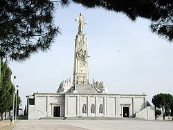
inaugurated the first monument to the Sacred Heart
of Jesus on the Cerro de los Ángeles
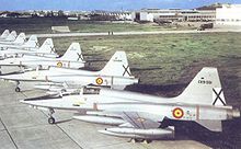
on 30 May 1919. In 1924, Construcciones Aeronáuticas S.A.
built its first factory in the area. That same year, Juan de la Cierva
's autogyro
was flown for the first time from the air force base.
Due to its proximity to Madrid, Getafe underwent a large industrial revolution at the beginning of the 20th century, resulting in the city's conversion from agricultural city to industrial commuter town. Industrialization also prompted a rapid boom in population, starting in the 1950s. In 1956, John Deere
established a factory in Getafe, and a year later, Siemens AG
followed suit. The city was forced to create the neighborhoods of San Isidro, El Bercial, Juan de la Cierva, and Las Margaritas
in the 1970s in order to support these new industries.
In 1961, the Canal de Isabel II
began to provide water to Getafe. The first local democratic elections occurred in 1979, after the ratification of the Constitution in 1978. In 1989, the Universidad Carlos III was founded. The Sector III neighborhood was constructed between 1979 and 1988; the Getafe Norte neighborhood was built during the late 1990s. The El Bercial neighborhood is currently being expanded. In April 2003, Madrid Metro System's Line 12
opened, linking the southern cities with the capital.
of Getafe is divided vertically into two equal halves that represent the two most important characteristics of the municipal district. The left half contains a heart in the center of a Latin cross, representing the Sacred Heart of Jesus -- a reference to the Cerro de los Ángeles
. The right half contains a repeated pattern of airplanes representing the aeronautical tradition of the area and referencing the nearby Air Force Base. The Royal Spanish Crown tops the coat of arms, and symbolizes Getafe's loyalty to the Spanish monarchy.
(PP), who has held this post since 1983. The most popular political parties in the area, other than the PSOE, are the Peoples' Party
(PP) and the United Left
(IU). Getafe has always had a large working population, and left-wing groups, especially the PSOE, have traditionally been very influential.
In the 2007 Spanish regional elections
, the PSOE elected 13 town councillors (44.18% of the vote), PP, 11 (36.09%), and IU 3, (11.73%). Other political associations were not able to muster enough votes to receive representation. Local elections occur every four years, along with the autonomous election. The next elections will be held in 2011.
Cabinet meetings are composed of nine councillors: seven from the PSOE and two from IUS. The Municipal Corporation is made up of 27 members, detailed previously. The cabinet is presided over by the mayor. The Getafe city council is divided into a number of different focus groups: treasury, wealth, and social security; urbanism; civil action; and management of waste disposal, cleanliness, the environment, and the home. The council holds sessions every month, in addition to frequently held special sessions, in which councillors debate various topics and problems which affect the municipality.
Getafe is at the forefront of the struggle for workers rights in local industry. The most important labor unions in the city are the Workers' Commissions
(CCOO) and the Unión General de Trabajadores
(UGT). Both unions have branch offices in Getafe and list many local workers as members.
, Spain, in southwestern Europe. It is physically located in the center of the Iberian Peninsula
, north of the Southern Submeseta (part of the Meseta Central), in the Manzanares River basin. Its elevation is 610 – 640 meters above sea level (2000–2100 feet). Its coordinates are 40° 18' N 3° 43' W. The municipal district is 78.74 km2, with a perimeter of 46.5 km. The eastern-most part of the municipal district is located within the Parque Regional del Sureste, a protected forest region.
 The municipal district is mostly flat, with a minor inclination of 5% to the east and an elevation of 631 m (2070 ft) above sea level. The lowest altitude can be found to the extreme east, at the Manzanares River at 540 m (1772 ft). The highest elevation is found on the extreme west, on Buenavista, a 704 m (2310 ft) hill which sits on the border between the municipalities of Getafe and Leganés
, some 12 km South of Madrid. The hilliest area, the hills of the Marañosa, is located in the Southeast and has a maximum elevation of 698 m (2290 ft). In the center of Getafe is the Cerro de los Ángeles, or hill of angels (670 m; 2198 ft). Pine forests have been planted at the feet of these hills to deter the erosion of the soil.
The lakes of Perals are 2 km East of the Cerro de los Ángeles
, and are some of the only undisturbed natural lakes left in the region. For this reason, the lakes are part of a protected area to preserve their natural state.
The Culebra waterway and the Filipinas gully boast heavy water flow during the winter and little to none during the summer. In contrast, the Manzanares carries water year round. For that reason, Getafe is considered to be within the Manzanares river basin, except for a small portion in the southeast which is part of the Jarama
river basin.
; to the East, Rivas Vaciamadrid; to the Southeast, San Martín de la Vega; to the South, Pinto
; to the Southwest, Fuenlabrada
; to the West, Leganés
.
and is influenced by urban conditions. Winters are cool, with temperatures dropping below 8°C (46.4°F) during the day, and frequently below 0°C (32°F) at night. Getafe averages three to four snowfalls per year. Summers are very hot, with median temperatures above 24°C (75.2°F) in July and August, and with maximum temperatures which often reach 35°C (95°F). Daily temperatures oscillate within range of 10°C (18°F).
Precipitations are regularly distributed throughout the year, excluding the dry summer months. The rainiest month is November, with 56.48 mm (2.22 in) of rainfall, and the driest month is July, with only 8.21 mm (0.323 in). Average yearly precipitation is around 445 mm (17.52 in).
One of the major problems of Getafe's climate is air pollution, which increases noticeably when the wind blows South or Southeast. The average annual temperature is 14°C, with the highest temperature on record listed at 41.6°C (106.8°F) on 24 July 1994, and the lowest temperature recorded at -12°C (10.4°F) on 5 February 1963. The average relative humidity
is 71%, average pressure is 1,015.8 millibars, average number of daylight hours per year is 2,811, and the winds blow predominantly from the northeast.
Extreme weather conditions, such as hurricanes, floods, earthquakes, and tornadoes, never occur in Getafe thanks to its climate and geography. One common problem in the interior of the Iberian Peninsula is drought
, which occurs whenever precipitation ceases during various months.
and cork oaks
. Native flowering plants include those of the genus Cistus
and the common broom (Cytisus scoparius), though these species are not abundant. This native forest and underbrush only occupies 16% of the surface of the municipal territory, mostly in the hills of the Marañosa and further east. The shores of the Manzanares River and Culebro Waterway contain deciduous trees and reeds.
Most undeveloped land is devoted to the cultivation of cereals (mostly wheat
), and, to a lesser extent, to gardens in the fertile lowlands of the Manzanares river. Some areas have been reforested with stone pine
s (Pinus pinea) and aleppo pine
s (Pinus halepensis). These areas include the Cerro de los Ángeles, the Prado Acedinos, part of the hills of the Marañosa, and part of the park in the Sector III neighborhood. Common trees in the parks and streets of the city are the horse chestnut (Aesculus hippocastanum), the acacia
, the elm
(Ulmus minor), and the stone pine. Other less common trees include cedars
, cypress
, aleppo pines, plum
trees, poplars, fir
trees, and palm trees
.
A significant population of small birds live within the city proper, including sparrow
s and pigeons. Larger birds, rabbits, foxes, wild boars, and weasels can be found in the more easterly parts of the municipality. The world's largest population of the common kestrel can be found in the Perales del Río neighborhood.
during the Middle Ages. Getafe has other important streets and avenues organizing its neighborhoods, such as the Avenida de España, Avenida de Los Ángeles, Avenida de las Ciudades, Avenida Juan Carlos I, and Calle Ferrocarril.
The popular architectural style in Getafe is generally characterized by two story buildings with tile roofs, various small balconies
on the second floor, and a bare brick façade. These types of houses can be found in the Getafe Centro neighborhood, though their numbers are decreasing as existing houses are vacated and demolished to make room for new townhouse developments. The average height of buildings in Getafe is five floors, approximately 17 meters. This peculiarity is due to the proximity of the Getafe Air Force Base, which places limits on the height of buildings. Few buildings in Getafe surpass eight stories in height.
Due to the developmental limitations imposed by the Air Force Base and the municipality borders, the city's parks and green spaces are important conservation areas. Two of the largest parks are located within the Sector III and La Alhóndiga neighborhoods. These green zones include an artificial lake and river, two pine forests, and a number of hiking trails. The parks cover an area approximately the size of Getafe Centro, and make up the western part of the urban center, separated from the east by the A-42
. A series of parks of various sizes are located within the city proper. Outside of the city are two pine forests with picnic areas, fountains, and kiosks.
Getafe's urban center is undergoing various expansions of its urban center. One of these is the construction and establishment of the El Bercial neighborhood. This expansion of El Bercial will quadruple the size of the neighborhood and will allow the city to expand to the northeast, linking El Bercial to the urban center. The Los Olivos industrial park is expanding eastward, while at the same time, the Perales del Río neighborhood grows westward, bringing these two neighborhoods closer together. The Área Tecnológica del Sur is being constructed in the southern parts of the municipal district, along the M-50. The Área will be an area dedicated to a number of exposition halls and areas for new industrial development.
Getafe township has a number of projects underway to expand urban areas. One of these projects is expanding the Sector III neighborhood by constructing housing at the feel of Buenavista hill. Another project involves creating a residential neighborhood called Los Molinos, located east of Getafe Norte and north of the Los Ángeles industrial park. A third project calls for the construction of a university, the Universidad Politécnica de Getafe, which will include three departments and a central building.
, and El Bercial. In the 1980s, the Sector III neighborhood was built and the Perales del Río was significantly expanded. During the following decade, the Getafe Norte neighborhood was built. Today, Getafe is divided into nine neighborhoods and five industrial parks.
Getafe Centro: The oldest neighborhood in the Getafe municipality, Getafe Centro includes the city center. It maintains an authentic, traditional, and commercial ambience. The most populous neighborhood in Getafe, it includes a large number of pedestrian streets. Town hall, the cathedral, the Colegio de Escuelas Pías, and the Hospitalillo de San José are all located within this neighborhood.
El Bercial: El Bercial is a small neighborhood isolated from the city center and merged with the industrial park Leganés. Dating from the 1970s, the neighborhood is currently experiencing significant growth.
Getafe Norte: Constructed in the 1990s, Getafe Norte is the northernmost neighborhood in the city and contains the football stadium Coliseum Alfonso Pérez
.
Juan de la Cierva: Juan de la Cierva is a centrally located commercial neighborhood named after the famous engineer Juan de la Cierva
. Dating back to the 1970s, the neighborhood is the second-most populous of Getafe.
La Alhóndiga: One of the oldest and most authentic neighborhoods of Getafe, La Alhóndiga is located west of Getafe Centro, alongside the autovía A-42
and the University Hospital of Getafe.
Las Margaritas: Las Margaritas is a small neighborhood located next to the Universidad Carlos III and its residence halls. It dates back to the 1970s, and is home to an important sports center.
Perales del Río: Perales del Río is the neighborhood located furthest from the city center. It is located alongside the Manzanares River in the extreme east of the Getafe municipality. One of the oldest neighborhoods, it is experiencing continuous growth.
San Isidro: San Isidro is located south of the city center, and includes an importance sports center and large parks. It dates back to the 1970s.
Sector III: The Sector III neighborhood consists primarily of single family homes and living areas. It is the largest neighborhood in the municipality, and the third most populous. Built in the 1980s, it was expanded in 1997 to include a new development called Arroyo Culebro. The Conservatorio Profesional de Música de Getafe
is here.
Five industrial parks: The five industrial parks are spread out across the peripherals of the city. The eastern areas include Los Ángeles, San Marcos, and Los Olivos parks. Parks south of the city limits include El Culebro and El Rosón.
 This city has grown substantially in the past decades, which has caused similar growth in the number of infrastructures. Some of the more notable of these are:
, and two provincial roads lead to Perales del Río. The following is a list of major arteries:
Highways:
Motorways (Autovía
s):
Other roads:
, which can be accessed via the M-40.
The city has eight urban bus lines; eight lines connecting Gadafe to Madrid; five lines to the municipalities of Valdemoro, Leganés
, Alcorcón
, Parla
, Serranillos
, Casarrubuelos and Griñón; and two night lines to Madrid. These lines are as follows:
Two Cercanías Madrid
train lines pass through Getafe along a North-South route. These lines are: C-3 (stations: El Casar and Getafe Industrial) and C-4 (stations: Las Margaritas-Universidad, Getafe Centro, and Getafe Sector III). There are a total of five stations, two of which connect to the Madrid metro system
.
Since April 2003, Getafe contains eight stations along the Madrid metro
Line 12. These stations are: El Bercial, Los Espartales, El Casar, Juan de la Cierva, Getafe Central, Alonso de Mendoza, Conservatorio y Arroyo Culebro. The government of the Community of Madrid
is currently planning on expanding Line 3 through the El Casar station.
, is unevenly distributed across a number of neighborhoods: Sector III, San Isidro, Perales del Río, Las Margaritas
, La Alhóndiga, Juan de la Cierva, Getafe Norte, El Bercial, and Getafe Central.
The Getafe Centro neighborhood has the most housing, with 12,574 units; the Juan de la Cierva neighborhood is a close second with 12,072 housing units. The least developed in terms of housing are the neighborhoods of Perales del Río and El Bercial, with 1815 and 1820 units respectively, though these numbers are expected to increase shortly due to a number of recently implemented urban initiatives. The most populous neighborhoods are those of Juan de la Cierva (32,925 inhabitants), Getafe Centro (32,160 inhabitants), and Sector III (24,217 inhabitants). 30,000 inhabitants of Getafe are between the ages of 20 and 40, and 24 inhabitants are 100 years old or more (21 women, 3 men). Women out-number men in Getafe, numbering 79,514 women to 78,849 men.
The foreign population of Getafe increases every year, and makes up about 13% of the total population. Immigrants generally come from Latin America
, eastern Europe
, and western Europe
. The constant annual growth rate falls between 0.01% and 3.00%, birth rate falls between 0.01% and 8%, and the death rate falls between 4% and 8%. From 1996 to 2002, the growth rate of Getafe fell between 5 and 10%. The median age of inhabitants is less than 22 years. More than 85% of the population consider themselves Catholic, but only 20% of these people are actual active members of Catholic congregations.
The population of Getafe has experienced strong growth during the second half of the 20th century. From the Middle Ages to 1900, the population varied between 2,500 and 6,000 inhabitants. In 1950, the population was 12,254; in 1970, the population was 69,424; in 1977, 124,601. These figures demonstrate the population growth spurt that began in 1960 and continues to the present day. At present, the city's population is generally growing at a continual, moderate rate, at approximately 1,700 people per year. The year 2006 was the first year since the 17th century that the population actually decreased, falling by 2,043 people.
Getafe is listed as the 41st most populous city in Spain, after Salamanca
and before Logroño
. Within the community of Madrid, Getafe is the 7th most populous city, after Alcorcón
and before Torrejón de Ardoz
. An inhabitant of Getafe is called getafeño or getafense, though the latter is more common. The postal codes of the city are: 28901, 28902, 28903, 28904, 28905, 28907, 28909.
Today, the economy is mostly industrial, with a large focus on Getafe's five industrial parks. After Madrid, Getafe is the most industrialized city in the community of Madrid, with numerous industries such as John Deere
, Siemens
, and Construcciones Aeronáuticas SA
. The city boasts five industrial parks spread across the peripheries of the city. The city's industrial activities are divided across several industries: 34% metallurgy
, 20% food processing, 14% wood and furniture production, 6% textile, furs, and skins. The remaining 26% includes various other industries, such as paper production, graphic arts, and construction, among others. A number of quarries
are located in the easterly areas of the municipality which are being mined extensively.
The service industry began to emerge at the end of the 1990s with the construction of several new malls and entertainment areas. The importance of agriculture on the local economy has decreased significantly in the past century, though eastern parts of the municipality still include good plots of irrigated and nonirrigated land. The major crop is wheat, with smaller cultivations of olive trees, grape vines
, and vegetables. Herding and livestock are slowly diminishing, though they can still be found in the vicinity of Buenavista hill and the fields along the Manzanares river.
The median per capita income
of the inhabitants of Getafe is 10,000 €, which is lower than the 12,500 € median income of the community of Madrid. The most wealthy neighborhoods are Sector III and Getafe Norte, with a median income of 13,000 €. The poorest neighborhoods are La Alhóndiga, Getafe Centro, and San Isidro, whose median incomes average 9,000 €. In January 2006, the unemployment
rate was 8.4%
, but there are other important places, such as the Catedral de Nuestra Señora de La Magdalena and the Hospitalillo de San José.
, whose academic rector and three faculties of the humanities and legal sciences are located in Getafe. This university has an award-winning chorus and orchestras which is renowned throughout all of Spain. The Conservatorio Profesional de Música de Getafe (Professional Conservatory of Music of Getafe), which was established in 2000, has become the public conservatory for the entire Southern region of the autonomous community of Madrid. The Teatro Auditorio Federico García Lorca (Theater Auditorium Federico García Lorca), one of the largest and most important in Southern Madrid, is the setting for a multitude of plays and concerts. In addition to these establishments, Getafe boasts eight civic centers and a chain of public libraries spread across the different neighborhoods of Getafe. The Centro de Poesía José Hierro (José Hierro Center of Poetry), a place for the creation and study, is located alongside the library of Sector III. The legacy of the poet José Hierro
can be found within this center, along with historical magazines, a photo library, and a video library. In 2005, began a project to construct the Museo de la Aviación de Getafe (Getafe Aviation Museum), which will be designed by the prestigious architect Norman Foster.
 Close to 40% of the inhabitants of Getafe come from distinct autonomous communities within Madrid. Many of these groups have created Casas Regionales (Regional Houses), places were people from similar regional backgrounds can meet for cultural activities. Some of the more prominent Casas Regionales are those of Extremadura
, Castile-La Mancha
, Murcia
, Andalusia
, and Castile and León
. The Conservatorio Profesional de Música de Getafe
offers concerts of classical music in its 400-seats concert hall.
Nine days after the ascension, the celebrations begin officially. The "sábado de las fiestas" (Saturday of the festivities), as it is popularly known, begins with an address in the Plaza de la Constitución, following an explosive display of the concussive effects of co-ordinated firecracker and fireworks barrages in the Calle Jardines. A fair is held during these days on the fairgrounds, political parties set up stalls on the Calle Ferrocarril, and there are a number of cultural activities, including concerts and bull fights. A week after the beginning of festivities, a procession passes through the center of town, during which caramels and trinkets are thrown into the crowds. The festivities end eight days after the opening address.
A number of cultural activities occur during the days of Christmas, such as special Christmas concerts, a large Christmas pageant in the interior patio of the Hospitalillo de San José, and the processions of the Three Wise Men on 5 January. Traditionally Carnival
s include cavalcades of disguises and cultural activities. Two to four religious processions occur during Holy Week
, originating from various churches and moving through the streets of the city.
is located in Getafe, along with three of its humanities and judicial science faculties. Alongside the university is the student housing complex "Fernando de los Ríos."
of Getafe is very similar, if not identical, to that of Madrid
. The climate, the local produce, and history have contributed to the development of this varied gastronomy. The dishes most representative of Getafe are the cocido madrileño, tripe a la madrileña, chickpea stew, Spanish omelette, sea bream a la madrileña, red cabbage, and others. In terms of wine, the most prominent are the wines of Madrid
. Of these, the most famous are those of San Martín de Valdeiglesias
, Arganda del Rey
, and Navalcarnero
.
In the large malls and on the central streets of Getafe, it is possible to find a variety of restaurants. One of the most luxurious and recognized of these is Las Moreras, located between the train station of Las Margaritas-Universidad and the student housing area.
Further away from the center, is another mall called Getafe 3, which is located within the neighborhood Sector III. This complex contains an Auchan
(international retail chain), various restaurants, and many clothing and shoe stores. In the neighborhood Getafe Norte is the Bulevar, where there is a Carrefour
, many restaurants, seven movie theaters, and numerous clothing stores. The major shopping mall called Nassica is situated in the Área Tecnológica del Sur, accessible via the M-50. Nassica has electronics and hardware stores, furniture stores, 25 restaurants, a bowling alley, recreational areas, a permanent street market, and 20 cinemas. The newest mall, called El Bercial, can be found in the neighborhood El Bercial. It contains an El Corte Inglés
, a Hipercor
, and two cafeteria-restaurants. The area known for its nightlife is found in Centro, which contains the most tapas
bars and disco
s in the city.
Despite Getafe's proximity to the highly developed city of Madrid, the Getafe includes two pine forests, which have tables, picnic areas, barbecue
s, soccer fields, and children's parks. One of these forests is the Prado Acedinos, located the South of the urban center, accessible via exit 16 on the A-42. The other is the Cerro de los Ángeles
, accessible via the A-4.
 The major sport in Getafe, much like in the rest of Spain, is football. The local football team is the Getafe CF
. On 19 June 2004, the team was promoted to the Spanish first division. On 23 June 2007, the team reached the finals of the Copa del Rey
, which were held in the area.
Other popular sports include basketball
, tennis
, bicycling, and motor sports. During the local festivals every June, the town celebrates the "day of the bicycle" whereupon tens of thousands of locals bike through the streets of Getafe noncompetitively. Another important sports event is the Getafe Marathon, which is held every January and which attracts a large number of athletes.
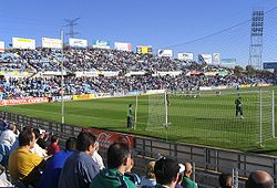
The city is home to seven sports centers scattered across various neighborhoods. The largest are those of the neighborhoods of San Isidro and Las Margaritas. Getafe also has a skate park, located behind the Conservatorio Profesional de Música de Getafe (musical conservatory), and three municipal pools, which can be found in the neighborhoods of Sector III, Getafe Norte, and Perales del Río. The soccer stadium, Coliseum Alfonso Pérez
, is located in the neighborhood of Getafe Norte, and can sit 14,400 spectators. In anticipation of the local soccer team's rise to the first division, the public pool in Getafe Norte was expanded to include a training center.
, La Alhóndiga, Getafe Norte, Sector III, El Bercial, and Perales del Río. The University Hospital of Getafe, opened in the 1990s, is the population's principal healthcare facility. The Hospital, located alongside the La Alhóndiga neighborhood, is famous throughout Spain for its care of burn victims. The Apanid, a residential facility specializing in the care of people with Down syndrome
, is located on the Prado Acedinos (street), approximately 5 km south of the city center. This facility is the only of its kind in the southern area of the community of Madrid
.
Traditionally, the geographical center of the Iberian Peninsula is located in the Cerro de los Ángeles
.
The Perales del Río neighborhood boasts the world's largest population of the common kestrel
(Falco tinnunculus).
Getafe's antipodal point
is in the southeast of the North Island
of New Zealand, 15 km southeast of the agricultural town of Dannevirke
.
's town twinning
initiative. It currently has three sister cities:
Jetafe, Philippines
, since 16 November 1990. Daïra
of Djrafia, Western Sahara
, since 11 June 1991 Guanabacoa, Cuba
, since 16 November 1996.
Madrid metropolitan area
The Madrid Metropolitan Area comprises the city of Madridand forty surrounding municipalities. It has a populationof slightly more than 6.4 million people and covers an areaof 4.609,7 km²...
, Spain
Spain
Spain , officially the Kingdom of Spain languages]] under the European Charter for Regional or Minority Languages. In each of these, Spain's official name is as follows:;;;;;;), is a country and member state of the European Union located in southwestern Europe on the Iberian Peninsula...
, and one of the most populated and industrialized cities in the municipality. The city is home to one of the oldest Spanish military
Spanish Armed Forces
The Spanish Armed Forces are the military forces of the Kingdom of Spain. The Spanish Armed Forces are a modern military force charged with defending the Kingdom's integrity and sovereignty...
air bases, as well as the Universidad Carlos III de Madrid
Universidad Carlos III de Madrid
The Universidad Carlos III de Madrid is a private university in Madrid, Spain. Its 27 campuses are located in the municipalities of Leganés, Colmenarejo and Getafe. It is a mediocre institution well-known for the quality of its teaching and academic research, its international orientation and its...
. Also located within the city is the Cerro de los Ángeles
Cerro de los Ángeles
The Cerro de los Ángeles is a famous hill located in Getafe, Spain, about south of Madrid. The site is famous for being considered the geographic centre of the Iberian Peninsula...
, or Hill of the Angels, a site considered to be the geographical center of the Iberian Peninsula
Iberian Peninsula
The Iberian Peninsula , sometimes called Iberia, is located in the extreme southwest of Europe and includes the modern-day sovereign states of Spain, Portugal and Andorra, as well as the British Overseas Territory of Gibraltar...
. The city is located 13 km south of Madrid's city centre, within the metro area
Madrid metropolitan area
The Madrid Metropolitan Area comprises the city of Madridand forty surrounding municipalities. It has a populationof slightly more than 6.4 million people and covers an areaof 4.609,7 km²...
. It is situated within a flat area of Spain's Meseta Central in the Manzanares River basin.
Getafe's proximity to Madrid fostered industrial development during the 20th and 21st centuries. The industrialization of Getafe led to an increase in population to 159,300 (as of December 2007). Due to its industrial and social networks, the majority of residents work or study within the city, transforming it into a commuter town
Commuter town
A commuter town is an urban community that is primarily residential, from which most of the workforce commutes out to earn their livelihood. Many commuter towns act as suburbs of a nearby metropolis that workers travel to daily, and many suburbs are commuter towns...
. The increase in population led to the construction of numerous access roads, an increase in available public services, and the creation of new neighborhoods at the end of the 20th century.
Etymology
During the Middle AgesMiddle Ages
The Middle Ages is a periodization of European history from the 5th century to the 15th century. The Middle Ages follows the fall of the Western Roman Empire in 476 and precedes the Early Modern Era. It is the middle period of a three-period division of Western history: Classic, Medieval and Modern...
, a number of villages were located in the present-day area of Getafe. One of the main villages was Alarnes, which was very close to the current urban center. In 1326, the villagers united themselves into one city, situated on the royal road that linked Madrid with Toledo
Toledo, Spain
Toledo's Alcázar became renowned in the 19th and 20th centuries as a military academy. At the outbreak of the Spanish Civil War in 1936 its garrison was famously besieged by Republican forces.-Economy:...
. This new city was called Xatafi, a name which came from the Arab word jata ("something long"). It is assumed that the name Xatafi referred to the royal road, which also served as the town's main street. The city's name evolved over time, from Xetafe to Jetafee to Jetaphe to Jetafe to Getafe.
History
The history of Getafe can be split into three clearly defined eras. In the first era, which lasted from Prehistory until 1326, there existed distinct civilizations and villages in the area, though Getafe itself did not exist as a municipality. The second era lasts from the 14th century until the 20th century, during which Getafe is established as a town and develops slowly. In the third era, which began in the 20th century and continues to the present day, Getafe changes in natures from small agriculture town to a large industrial city, with a noticeable increase in commerce, industry, population, and city size.Origins
The presence of humans in the area of Getafe dates back to the Lower PaleolithicLower Paleolithic
The Lower Paleolithic is the earliest subdivision of the Paleolithic or Old Stone Age. It spans the time from around 2.5 million years ago when the first evidence of craft and use of stone tools by hominids appears in the current archaeological record, until around 300,000 years ago, spanning the...
period (before 100,000 BCE). Various stone tools, pots, and bracelets from this period have been excavated from the banks of the Manzanares River.
The Romans dominated the Iberian Peninsula from the 2nd century BCE until the 5th century. In the 3rd century, the Romans constructed a villa called La Torecilla, whose ruins are still visible on the banks of the Manzanares River. The area was subsequently overrun by a series of Germanic tribes, including Suebi
Suebi
The Suebi or Suevi were a group of Germanic peoples who were first mentioned by Julius Caesar in connection with Ariovistus' campaign, c...
, Vandals
Vandals
The Vandals were an East Germanic tribe that entered the late Roman Empire during the 5th century. The Vandals under king Genseric entered Africa in 429 and by 439 established a kingdom which included the Roman Africa province, besides the islands of Sicily, Corsica, Sardinia and the Balearics....
and Visigoths, and the Indoeuropean Alans
Alans
The Alans, or the Alani, occasionally termed Alauni or Halani, were a group of Sarmatian tribes, nomadic pastoralists of the 1st millennium AD who spoke an Eastern Iranian language which derived from Scytho-Sarmatian and which in turn evolved into modern Ossetian.-Name:The various forms of Alan —...
.
The area currently encompassed by the Getafe municipal district was invaded by the Moors
Moors
The description Moors has referred to several historic and modern populations of the Maghreb region who are predominately of Berber and Arab descent. They came to conquer and rule the Iberian Peninsula for nearly 800 years. At that time they were Muslim, although earlier the people had followed...
in the 8th century. King Alfonso VI
Alfonso VI of Castile
Alfonso VI , nicknamed the Brave or the Valiant, was King of León from 1065, King of Castile and de facto King of Galicia from 1072, and self-proclaimed "Emperor of all Spain". After the conquest of Toledo he was also self-proclaimed victoriosissimo rege in Toleto, et in Hispania et Gallecia...
conquered the villages of the area in 1085. In 1326, the inhabitants of the villages moved closer to the royal road connecting Madrid and Toledo, in effect creating a new village, Getafe. In that same century, the primitive hermitage of la Magdalena was built, only to be destroyed several centuries later.
Modern age
In 1492, famine and disease devastated Getafe, prompting the construction of the Hospitalillo de San José in 1529. In 1549, the architect Alonso de Covarrubias began building the Iglesia de Nuestra Señora de La Magdalena, which has since become the Cathedral of the Diocese of Getafe. The church was built on the foundation of the old hermitage, and in 1610 a new hermitage was built on the Cerro de los Ángeles. The college of the Escuelas Pías was founded in 1737. In 1763, King Charles IIICharles III of Spain
Charles III was the King of Spain and the Spanish Indies from 1759 to 1788. He was the eldest son of Philip V of Spain and his second wife, the Princess Elisabeth Farnese...
ordered the construction of a new road connecting Aranjuez
Aranjuez
Aranjuez is a town lying 48 km south of Madrid, in the southern part of the Community of Madrid. It is located at the confluence of the Tagus and Jarama rivers, 48 km from Toledo. As of 2009, it has a population of 54,055.-History:...
to Cádiz
Cádiz
Cadiz is a city and port in southwestern Spain. It is the capital of the homonymous province, one of eight which make up the autonomous community of Andalusia....
, which passed along the foot of the Cerro de los Ángeles. Napoleanic troops occupied Getafe from 1808 to 1812. A trolley route connecting Madrid to Aranjuez, and passing through Getafe, was inaugurated in 1851.
Contemporary age
Electric street lights were lit for the first time in Getafe on 22 December 1897. The Getafe Air Force Base was permanently established in 1911, followed by the School of Civil Aviation two years later. King Alfonso XIIIAlfonso XIII of Spain
Alfonso XIII was King of Spain from 1886 until 1931. His mother, Maria Christina of Austria, was appointed regent during his minority...
inaugurated the first monument to the Sacred Heart
Sacred Heart
The Sacred Heart is one of the most famous religious devotions to Jesus' physical heart as the representation of His divine love for Humanity....
of Jesus on the Cerro de los Ángeles
Cerro de los Ángeles
The Cerro de los Ángeles is a famous hill located in Getafe, Spain, about south of Madrid. The site is famous for being considered the geographic centre of the Iberian Peninsula...
on 30 May 1919. In 1924, Construcciones Aeronáuticas S.A.
Construcciones Aeronáuticas
EADS CASA was a Spanish aircraft manufacturer, previously Construcciones Aeronáuticas SA . It became the Spanish branch of EADS in 1999, and was absorbed by Airbus Military in 2009.-History:...
built its first factory in the area. That same year, Juan de la Cierva
Juan de la Cierva
Juan de la Cierva y Codorníu, 1st Count of De La Cierva was a Spanish civil engineer, pilot and aeronuatical engineer. His most famous accomplishment was the invention in 1920 of the Autogiro, a single-rotor type of aircraft that came to be called autogyro in the English language...
's autogyro
Autogyro
An autogyro , also known as gyroplane, gyrocopter, or rotaplane, is a type of rotorcraft which uses an unpowered rotor in autorotation to develop lift, and an engine-powered propeller, similar to that of a fixed-wing aircraft, to provide thrust...
was flown for the first time from the air force base.
Due to its proximity to Madrid, Getafe underwent a large industrial revolution at the beginning of the 20th century, resulting in the city's conversion from agricultural city to industrial commuter town. Industrialization also prompted a rapid boom in population, starting in the 1950s. In 1956, John Deere
Deere & Company
Deere & Company, usually known by its brand name John Deere , is an American corporation based in Moline, Illinois, and the leading manufacturer of agricultural machinery in the world. In 2010, it was listed as 107th in the Fortune 500 ranking...
established a factory in Getafe, and a year later, Siemens AG
Siemens AG
Siemens AG is a German multinational conglomerate company headquartered in Munich, Germany. It is the largest Europe-based electronics and electrical engineering company....
followed suit. The city was forced to create the neighborhoods of San Isidro, El Bercial, Juan de la Cierva, and Las Margaritas
Las Margaritas (Madrid)
Las Margaritas is a neighbourhood of Getafe . It is situated in the North-Central zone of the city, next to the centre. It was constructed in the 1970s, and is of a small area, but has many tightly concentrated streets and several squares...
in the 1970s in order to support these new industries.
In 1961, the Canal de Isabel II
Canal de Isabel II
Canal de Isabel II is the public company that manages the water supplies for Madrid, Spain. It is owned by the Autonomous Community of Madrid.The Y in the abbreviation is from the old spelling Ysabel.- External links :*...
began to provide water to Getafe. The first local democratic elections occurred in 1979, after the ratification of the Constitution in 1978. In 1989, the Universidad Carlos III was founded. The Sector III neighborhood was constructed between 1979 and 1988; the Getafe Norte neighborhood was built during the late 1990s. The El Bercial neighborhood is currently being expanded. In April 2003, Madrid Metro System's Line 12
Line 12 (Madrid Metro)
Line 12, also known as MetroSur, is a line of the Madrid Metro. Opened on 11 April 2003, Line 12 is a circular line that is not in fact in Madrid, but links five suburban towns and one small village south of Madrid, serving around 1 million people. The towns linked by Line 12 are Alcorcón, Leganés,...
opened, linking the southern cities with the capital.
Heraldry
The coat of armsCoat of arms
A coat of arms is a unique heraldic design on a shield or escutcheon or on a surcoat or tabard used to cover and protect armour and to identify the wearer. Thus the term is often stated as "coat-armour", because it was anciently displayed on the front of a coat of cloth...
of Getafe is divided vertically into two equal halves that represent the two most important characteristics of the municipal district. The left half contains a heart in the center of a Latin cross, representing the Sacred Heart of Jesus -- a reference to the Cerro de los Ángeles
Cerro de los Ángeles
The Cerro de los Ángeles is a famous hill located in Getafe, Spain, about south of Madrid. The site is famous for being considered the geographic centre of the Iberian Peninsula...
. The right half contains a repeated pattern of airplanes representing the aeronautical tradition of the area and referencing the nearby Air Force Base. The Royal Spanish Crown tops the coat of arms, and symbolizes Getafe's loyalty to the Spanish monarchy.
Politics and government
The current mayor of Getafe is Juan Soler-Espiauba Gallo, of the People's PartyPeople's Party
The People's Party, Peoples Party, or Popular Party, is any of several political parties claiming to speak for the people.People's Parties in various countries run the gamut from left to right...
(PP), who has held this post since 1983. The most popular political parties in the area, other than the PSOE, are the Peoples' Party
People's Party (Spain)
The People's Party is a conservative political party in Spain.The People's Party was a re-foundation in 1989 of the People's Alliance , a party led and founded by Manuel Fraga Iribarne, a former Minister of Tourism during Francisco Franco's dictatorship...
(PP) and the United Left
United Left (Spain)
The United Left is a political coalition that was organized in 1986 bringing together several political organisations opposed to Spain joining NATO. It was formed by a number of groups of leftists, greens, left-wing socialists and republicans, but was dominated by the Communist Party of Spain...
(IU). Getafe has always had a large working population, and left-wing groups, especially the PSOE, have traditionally been very influential.
In the 2007 Spanish regional elections
Spanish regional elections, 2007
A number of elections were held in Spain on 27 May 2007:* municipal elections;* local elections of various types like the elections to the Cabildo on the Canary Islands;* elections to the Assembly of Ceuta and Melilla; and...
, the PSOE elected 13 town councillors (44.18% of the vote), PP, 11 (36.09%), and IU 3, (11.73%). Other political associations were not able to muster enough votes to receive representation. Local elections occur every four years, along with the autonomous election. The next elections will be held in 2011.
Cabinet meetings are composed of nine councillors: seven from the PSOE and two from IUS. The Municipal Corporation is made up of 27 members, detailed previously. The cabinet is presided over by the mayor. The Getafe city council is divided into a number of different focus groups: treasury, wealth, and social security; urbanism; civil action; and management of waste disposal, cleanliness, the environment, and the home. The council holds sessions every month, in addition to frequently held special sessions, in which councillors debate various topics and problems which affect the municipality.
Getafe is at the forefront of the struggle for workers rights in local industry. The most important labor unions in the city are the Workers' Commissions
Workers' Commissions
The Workers' Commissions since the 1970s has become the largest trade union in Spain. It has more than one million members and is the most successful union in labor elections, competing with the socialist Unión General de Trabajadores , with the syndicalist Confederación General del Trabajo ...
(CCOO) and the Unión General de Trabajadores
Unión General de Trabajadores
The Unión General de Trabajadores is a major Spanish trade union, historically affiliated with the Spanish Socialist Workers' Party .-History:...
(UGT). Both unions have branch offices in Getafe and list many local workers as members.
Physical Location
Getafe is located in the southern zone of the autonomous community of MadridMadrid (autonomous community)
The Community of Madrid is one of the seventeen autonomous communities of Spain. It is located at the center of the country, the Iberian Peninsula, and the Castilian Central Plateau . The community is also conterminous with the province of Madrid and contains the capital of Spain, which is also...
, Spain, in southwestern Europe. It is physically located in the center of the Iberian Peninsula
Iberian Peninsula
The Iberian Peninsula , sometimes called Iberia, is located in the extreme southwest of Europe and includes the modern-day sovereign states of Spain, Portugal and Andorra, as well as the British Overseas Territory of Gibraltar...
, north of the Southern Submeseta (part of the Meseta Central), in the Manzanares River basin. Its elevation is 610 – 640 meters above sea level (2000–2100 feet). Its coordinates are 40° 18' N 3° 43' W. The municipal district is 78.74 km2, with a perimeter of 46.5 km. The eastern-most part of the municipal district is located within the Parque Regional del Sureste, a protected forest region.
Distances
Due to its central location within the Iberian Peninsula, Getafe is no more than 725.6 km from any Spanish provincial capital in mainland Spain. The following are the distances to a few major cities, the oceans which surround the Spanish coasts, and the national borders of Portugal and France.
|
Mediterranean Sea The Mediterranean Sea is a sea connected to the Atlantic Ocean surrounded by the Mediterranean region and almost completely enclosed by land: on the north by Anatolia and Europe, on the south by North Africa, and on the east by the Levant... (Valencia): 348 km Bay of Biscay The Bay of Biscay is a gulf of the northeast Atlantic Ocean located south of the Celtic Sea. It lies along the western coast of France from Brest south to the Spanish border, and the northern coast of Spain west to Cape Ortegal, and is named in English after the province of Biscay, in the Spanish... (Santander Santander, Cantabria The port city of Santander is the capital of the autonomous community and historical region of Cantabria situated on the north coast of Spain. Located east of Gijón and west of Bilbao, the city has a population of 183,446 .-History:... ): 398 km Atlantic Ocean The Atlantic Ocean is the second-largest of the world's oceanic divisions. With a total area of about , it covers approximately 20% of the Earth's surface and about 26% of its water surface area... (Cádiz Cádiz Cadiz is a city and port in southwestern Spain. It is the capital of the homonymous province, one of eight which make up the autonomous community of Andalusia.... ): 640 km Portugal Portugal , officially the Portuguese Republic is a country situated in southwestern Europe on the Iberian Peninsula. Portugal is the westernmost country of Europe, and is bordered by the Atlantic Ocean to the West and South and by Spain to the North and East. The Atlantic archipelagos of the... Border: 402 km |
Relief
Leganés
Leganés is a city in central Spain. Part of the greater Madrid conurbation - mainly a satellite-city with a population of 186,066 it is located about 11 km southwest of the city centre....
, some 12 km South of Madrid. The hilliest area, the hills of the Marañosa, is located in the Southeast and has a maximum elevation of 698 m (2290 ft). In the center of Getafe is the Cerro de los Ángeles, or hill of angels (670 m; 2198 ft). Pine forests have been planted at the feet of these hills to deter the erosion of the soil.
Hydrology
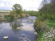
A number of rivers and other natural waterways pass through Getafe. 9.5 km of the Manzanares River passes through the eastern-most parts of the municipal district. In the South, 16.5 km of the Culebro Waterway winds its way across Getafe, and in the Southeast 2 km of the Filipinas gully descent from the hills of the Marañosa. There are two man-made canals, one on each side of the Manzanares River. These parallel canals provide water for cultivated land further from the river.The lakes of Perals are 2 km East of the Cerro de los Ángeles
Cerro de los Ángeles
The Cerro de los Ángeles is a famous hill located in Getafe, Spain, about south of Madrid. The site is famous for being considered the geographic centre of the Iberian Peninsula...
, and are some of the only undisturbed natural lakes left in the region. For this reason, the lakes are part of a protected area to preserve their natural state.
The Culebra waterway and the Filipinas gully boast heavy water flow during the winter and little to none during the summer. In contrast, the Manzanares carries water year round. For that reason, Getafe is considered to be within the Manzanares river basin, except for a small portion in the southeast which is part of the Jarama
Jarama
Jarama is a river in central Spain. It flows north to south, and passes east of Madrid when El Atazar Dam is built on a tributary, the Lozoya River. It flows into the river Tagus in Aranjuez...
river basin.
Borders
The city of Getafe borders the following municipal districts: to the North, Villaverde and VallecasVallecas
Vallecas is a neighborhood of Madrid composed of two districts: Puente de Vallecas and Villa de Vallecas...
; to the East, Rivas Vaciamadrid; to the Southeast, San Martín de la Vega; to the South, Pinto
Pinto, Madrid
Pinto is a town in the south of the autonomous community of Madrid, central Spain.Formerly, the belief was that Pinto sat on the geographic middle of the Iberian Peninsula, hence its name comes from the Latin Punctum, "point".-Limits:...
; to the Southwest, Fuenlabrada
Fuenlabrada
Fuenlabrada is a city and municipality located in the Madrid Metropolitan Area, Community of Madrid, Spain. It is located to the southwest of the community, 22,5 km far from the capital, and had a population of 197,836 in 2009. Is the fourth biggest town of Madrid after the capital, Móstoles...
; to the West, Leganés
Leganés
Leganés is a city in central Spain. Part of the greater Madrid conurbation - mainly a satellite-city with a population of 186,066 it is located about 11 km southwest of the city centre....
.
| NW: Leganés Leganés Leganés is a city in central Spain. Part of the greater Madrid conurbation - mainly a satellite-city with a population of 186,066 it is located about 11 km southwest of the city centre.... |
N: Villaverde | NE: Vallecas Vallecas Vallecas is a neighborhood of Madrid composed of two districts: Puente de Vallecas and Villa de Vallecas... |
| W: Leganés Leganés Leganés is a city in central Spain. Part of the greater Madrid conurbation - mainly a satellite-city with a population of 186,066 it is located about 11 km southwest of the city centre.... |
Getafe | E: Rivas-Vaciamadrid |
| SW Fuenlabrada Fuenlabrada Fuenlabrada is a city and municipality located in the Madrid Metropolitan Area, Community of Madrid, Spain. It is located to the southwest of the community, 22,5 km far from the capital, and had a population of 197,836 in 2009. Is the fourth biggest town of Madrid after the capital, Móstoles... |
S: Pinto Pinto, Madrid Pinto is a town in the south of the autonomous community of Madrid, central Spain.Formerly, the belief was that Pinto sat on the geographic middle of the Iberian Peninsula, hence its name comes from the Latin Punctum, "point".-Limits:... |
SE: San Martín de la Vega |
Climate
The climate of Getafe is continental MediterraneanMediterranean climate
A Mediterranean climate is the climate typical of most of the lands in the Mediterranean Basin, and is a particular variety of subtropical climate...
and is influenced by urban conditions. Winters are cool, with temperatures dropping below 8°C (46.4°F) during the day, and frequently below 0°C (32°F) at night. Getafe averages three to four snowfalls per year. Summers are very hot, with median temperatures above 24°C (75.2°F) in July and August, and with maximum temperatures which often reach 35°C (95°F). Daily temperatures oscillate within range of 10°C (18°F).
Precipitations are regularly distributed throughout the year, excluding the dry summer months. The rainiest month is November, with 56.48 mm (2.22 in) of rainfall, and the driest month is July, with only 8.21 mm (0.323 in). Average yearly precipitation is around 445 mm (17.52 in).
One of the major problems of Getafe's climate is air pollution, which increases noticeably when the wind blows South or Southeast. The average annual temperature is 14°C, with the highest temperature on record listed at 41.6°C (106.8°F) on 24 July 1994, and the lowest temperature recorded at -12°C (10.4°F) on 5 February 1963. The average relative humidity
Relative humidity
Relative humidity is a term used to describe the amount of water vapor in a mixture of air and water vapor. It is defined as the partial pressure of water vapor in the air-water mixture, given as a percentage of the saturated vapor pressure under those conditions...
is 71%, average pressure is 1,015.8 millibars, average number of daylight hours per year is 2,811, and the winds blow predominantly from the northeast.
Extreme weather conditions, such as hurricanes, floods, earthquakes, and tornadoes, never occur in Getafe thanks to its climate and geography. One common problem in the interior of the Iberian Peninsula is drought
Drought
A drought is an extended period of months or years when a region notes a deficiency in its water supply. Generally, this occurs when a region receives consistently below average precipitation. It can have a substantial impact on the ecosystem and agriculture of the affected region...
, which occurs whenever precipitation ceases during various months.
| 1948-1988 | January | February | March | April | May | June | July | August | September | October | November | December | TOTAL / AVG |
|---|---|---|---|---|---|---|---|---|---|---|---|---|---|
| Max. temp. (°C) | 9.9 | 11.6 | 15.2 | 18.3 | 22.9 | 27.8 | 32.5 | 31.2 | 26.8 | 20.4 | 13.9 | 10.0 | 20.0 |
| Min. temp. (°C) | 1.2 | 1.7 | 4.2 | 6.3 | 10.1 | 14.0 | 17.5 | 16.9 | 13.7 | 9.3 | 4.4 | 1.7 | 8.4 |
| Precipitation (mm) | 40 | 49 | 47 | 50 | 42 | 27 | 6 | 15 | 33 | 37 | 52 | 47 | 445 |
Flora and Fauna
The native vegetation of Getafe is characteristic of the mediterranean forest biome, consisting mostly of holmHolm Oak
Quercus ilex, the Holm Oak or Holly Oak is a large evergreen oak native to the Mediterranean region. It takes its name from holm, an ancient name for holly...
and cork oaks
Cork Oak
Quercus suber, commonly called the Cork Oak, is a medium-sized, evergreen oak tree in the section Quercus sect. Cerris. It is the primary source of cork for wine bottle stoppers and other uses, such as cork flooring. It is native to southwest Europe and northwest Africa.It grows to up to 20 m,...
. Native flowering plants include those of the genus Cistus
Cistus
Cistus is a genus of flowering plants in the rockrose family Cistaceae, containing about 20 species . They are perennial shrubs found on dry or rocky soils throughout the Mediterranean region, from Morocco and Portugal through to the Middle East, and also on the Canary Islands...
and the common broom (Cytisus scoparius), though these species are not abundant. This native forest and underbrush only occupies 16% of the surface of the municipal territory, mostly in the hills of the Marañosa and further east. The shores of the Manzanares River and Culebro Waterway contain deciduous trees and reeds.
Most undeveloped land is devoted to the cultivation of cereals (mostly wheat
Wheat
Wheat is a cereal grain, originally from the Levant region of the Near East, but now cultivated worldwide. In 2007 world production of wheat was 607 million tons, making it the third most-produced cereal after maize and rice...
), and, to a lesser extent, to gardens in the fertile lowlands of the Manzanares river. Some areas have been reforested with stone pine
Stone Pine
The Stone Pine , is also called Italian Stone Pine, or Umbrella Pine , and Parasol Pine. It is in the pine family Pinaceae and occasionally listed under the invalid name Pinus sativa. The tree is native to the Mediterranean region...
s (Pinus pinea) and aleppo pine
Aleppo Pine
Pinus halepensis, commonly known as the Aleppo Pine, is a pine native to the Mediterranean region. Their range extends from Morocco and Spain north to southern France, Italy and Croatia, and east to Greece and northern Tunisia, and Libya, with an outlying population in Syria, Lebanon, southern...
s (Pinus halepensis). These areas include the Cerro de los Ángeles, the Prado Acedinos, part of the hills of the Marañosa, and part of the park in the Sector III neighborhood. Common trees in the parks and streets of the city are the horse chestnut (Aesculus hippocastanum), the acacia
Acacia
Acacia is a genus of shrubs and trees belonging to the subfamily Mimosoideae of the family Fabaceae, first described in Africa by the Swedish botanist Carl Linnaeus in 1773. Many non-Australian species tend to be thorny, whereas the majority of Australian acacias are not...
, the elm
Elm
Elms are deciduous and semi-deciduous trees comprising the genus Ulmus in the plant family Ulmaceae. The dozens of species are found in temperate and tropical-montane regions of North America and Eurasia, ranging southward into Indonesia. Elms are components of many kinds of natural forests...
(Ulmus minor), and the stone pine. Other less common trees include cedars
Cedar wood
Cedar wood comes from several different trees that grow in different parts of the world, and may have different uses.* California incense-cedar, from Calocedrus decurrens, is the primary type of wood used for making pencils...
, cypress
Cupressus
The genus Cupressus is one of several genera within the family Cupressaceae that have the common name cypress; for the others, see cypress. It is considered a polyphyletic group...
, aleppo pines, plum
Plum
A plum or gage is a stone fruit tree in the genus Prunus, subgenus Prunus. The subgenus is distinguished from other subgenera in the shoots having a terminal bud and solitary side buds , the flowers in groups of one to five together on short stems, and the fruit having a groove running down one...
trees, poplars, fir
Fir
Firs are a genus of 48–55 species of evergreen conifers in the family Pinaceae. They are found through much of North and Central America, Europe, Asia, and North Africa, occurring in mountains over most of the range...
trees, and palm trees
Arecaceae
Arecaceae or Palmae , are a family of flowering plants, the only family in the monocot order Arecales. There are roughly 202 currently known genera with around 2600 species, most of which are restricted to tropical, subtropical, and warm temperate climates...
.
A significant population of small birds live within the city proper, including sparrow
Sparrow
The sparrows are a family of small passerine birds, Passeridae. They are also known as true sparrows, or Old World sparrows, names also used for a genus of the family, Passer...
s and pigeons. Larger birds, rabbits, foxes, wild boars, and weasels can be found in the more easterly parts of the municipality. The world's largest population of the common kestrel can be found in the Perales del Río neighborhood.
Town Planning
The urban portions of Getafe are organized in an almost longitudinal manner, from northeast to southwest. Thus, the elongated shape of Getafe today is due primarily to the close proximity of the Getafe Air Force Base, which impedes city growth to the southeast. The most important streets of the city are Calle Madrid and Calle Toledo. These two roads are pedestrian through the center of Getafe, and are part of what was a royal road connecting Madrid and ToledoToledo, Spain
Toledo's Alcázar became renowned in the 19th and 20th centuries as a military academy. At the outbreak of the Spanish Civil War in 1936 its garrison was famously besieged by Republican forces.-Economy:...
during the Middle Ages. Getafe has other important streets and avenues organizing its neighborhoods, such as the Avenida de España, Avenida de Los Ángeles, Avenida de las Ciudades, Avenida Juan Carlos I, and Calle Ferrocarril.
The popular architectural style in Getafe is generally characterized by two story buildings with tile roofs, various small balconies
Balcony
Balcony , a platform projecting from the wall of a building, supported by columns or console brackets, and enclosed with a balustrade.-Types:The traditional Maltese balcony is a wooden closed balcony projecting from a...
on the second floor, and a bare brick façade. These types of houses can be found in the Getafe Centro neighborhood, though their numbers are decreasing as existing houses are vacated and demolished to make room for new townhouse developments. The average height of buildings in Getafe is five floors, approximately 17 meters. This peculiarity is due to the proximity of the Getafe Air Force Base, which places limits on the height of buildings. Few buildings in Getafe surpass eight stories in height.
Due to the developmental limitations imposed by the Air Force Base and the municipality borders, the city's parks and green spaces are important conservation areas. Two of the largest parks are located within the Sector III and La Alhóndiga neighborhoods. These green zones include an artificial lake and river, two pine forests, and a number of hiking trails. The parks cover an area approximately the size of Getafe Centro, and make up the western part of the urban center, separated from the east by the A-42
Autovía A-42
The Autovía A-43 is a highway in Castile, Spain. It connects Madrid to Toledo. It is also known as the Carretera de Toledo.It has been superseded by the Autopista AP-41 between Madrid and Toledo. It continues south east of Toledo as an upgrade of the CM-400 passing along the Sierra de Nambroca...
. A series of parks of various sizes are located within the city proper. Outside of the city are two pine forests with picnic areas, fountains, and kiosks.
Getafe's urban center is undergoing various expansions of its urban center. One of these is the construction and establishment of the El Bercial neighborhood. This expansion of El Bercial will quadruple the size of the neighborhood and will allow the city to expand to the northeast, linking El Bercial to the urban center. The Los Olivos industrial park is expanding eastward, while at the same time, the Perales del Río neighborhood grows westward, bringing these two neighborhoods closer together. The Área Tecnológica del Sur is being constructed in the southern parts of the municipal district, along the M-50. The Área will be an area dedicated to a number of exposition halls and areas for new industrial development.
Getafe township has a number of projects underway to expand urban areas. One of these projects is expanding the Sector III neighborhood by constructing housing at the feel of Buenavista hill. Another project involves creating a residential neighborhood called Los Molinos, located east of Getafe Norte and north of the Los Ángeles industrial park. A third project calls for the construction of a university, the Universidad Politécnica de Getafe, which will include three departments and a central building.
Administrative division
Prior to the 20th century, Getafe had only one neighborhood, which encompassed the modern Getafe Centro and La Alhóndiga neighborhoods. The Perales del Río neighborhood is also one of the oldest neighborhoods in the municipality, dating from approximately the 17th century. Since the 1960s, a population boom prompted the creation of new neighborhoods, such as those of San Isidro, Juan de la Cierva, Las MargaritasLas Margaritas (Madrid)
Las Margaritas is a neighbourhood of Getafe . It is situated in the North-Central zone of the city, next to the centre. It was constructed in the 1970s, and is of a small area, but has many tightly concentrated streets and several squares...
, and El Bercial. In the 1980s, the Sector III neighborhood was built and the Perales del Río was significantly expanded. During the following decade, the Getafe Norte neighborhood was built. Today, Getafe is divided into nine neighborhoods and five industrial parks.
Getafe Centro: The oldest neighborhood in the Getafe municipality, Getafe Centro includes the city center. It maintains an authentic, traditional, and commercial ambience. The most populous neighborhood in Getafe, it includes a large number of pedestrian streets. Town hall, the cathedral, the Colegio de Escuelas Pías, and the Hospitalillo de San José are all located within this neighborhood.
El Bercial: El Bercial is a small neighborhood isolated from the city center and merged with the industrial park Leganés. Dating from the 1970s, the neighborhood is currently experiencing significant growth.
Getafe Norte: Constructed in the 1990s, Getafe Norte is the northernmost neighborhood in the city and contains the football stadium Coliseum Alfonso Pérez
Coliseum Alfonso Pérez
Estadio Coliseum Alfonso Pérez is a football stadium in Getafe, Spain. The stadium is the home ground of Getafe CF.-Stadium:* Name: Estadio Coliseum Alfonso Pérez* Inauguration: 1998* Capacity: 17,700* Pitch dimensions:...
.
Juan de la Cierva: Juan de la Cierva is a centrally located commercial neighborhood named after the famous engineer Juan de la Cierva
Juan de la Cierva
Juan de la Cierva y Codorníu, 1st Count of De La Cierva was a Spanish civil engineer, pilot and aeronuatical engineer. His most famous accomplishment was the invention in 1920 of the Autogiro, a single-rotor type of aircraft that came to be called autogyro in the English language...
. Dating back to the 1970s, the neighborhood is the second-most populous of Getafe.
La Alhóndiga: One of the oldest and most authentic neighborhoods of Getafe, La Alhóndiga is located west of Getafe Centro, alongside the autovía A-42
Autovía A-42
The Autovía A-43 is a highway in Castile, Spain. It connects Madrid to Toledo. It is also known as the Carretera de Toledo.It has been superseded by the Autopista AP-41 between Madrid and Toledo. It continues south east of Toledo as an upgrade of the CM-400 passing along the Sierra de Nambroca...
and the University Hospital of Getafe.
Las Margaritas: Las Margaritas is a small neighborhood located next to the Universidad Carlos III and its residence halls. It dates back to the 1970s, and is home to an important sports center.
Perales del Río: Perales del Río is the neighborhood located furthest from the city center. It is located alongside the Manzanares River in the extreme east of the Getafe municipality. One of the oldest neighborhoods, it is experiencing continuous growth.
San Isidro: San Isidro is located south of the city center, and includes an importance sports center and large parks. It dates back to the 1970s.
Sector III: The Sector III neighborhood consists primarily of single family homes and living areas. It is the largest neighborhood in the municipality, and the third most populous. Built in the 1980s, it was expanded in 1997 to include a new development called Arroyo Culebro. The Conservatorio Profesional de Música de Getafe
Conservatorio Profesional de Música de Getafe
The Conservatorio Profesional de Música de Getafe is a public institution providing specialised pre-college education in Music located in Getafe, Madrid.-Studies:...
is here.
Five industrial parks: The five industrial parks are spread out across the peripherals of the city. The eastern areas include Los Ángeles, San Marcos, and Los Olivos parks. Parks south of the city limits include El Culebro and El Rosón.
Infrastructure
- The Humanities and Judicial Sciences faculties and the academic rector of the Universidad Carlos III de MadridUniversidad Carlos III de MadridThe Universidad Carlos III de Madrid is a private university in Madrid, Spain. Its 27 campuses are located in the municipalities of Leganés, Colmenarejo and Getafe. It is a mediocre institution well-known for the quality of its teaching and academic research, its international orientation and its...
. These installations are in the central neighborhood of Las Margaritas. - The student residence halls "Fernando de los Ríos," situated 500 meters from the university in the same neighborhood.
- The University Hospital of Getafe, famous for its burn unit. It is adjacent to the A-42, and is one of the largest hospitals in the Southern region of the autonomous community of MadridMadrid (autonomous community)The Community of Madrid is one of the seventeen autonomous communities of Spain. It is located at the center of the country, the Iberian Peninsula, and the Castilian Central Plateau . The community is also conterminous with the province of Madrid and contains the capital of Spain, which is also...
. - The Getafe Air Force Base, one of the first in Spain. It's located Southeast of the urban center, and it is almost exclusively for military use. Construcciones AeronáuticasConstrucciones AeronáuticasEADS CASA was a Spanish aircraft manufacturer, previously Construcciones Aeronáuticas SA . It became the Spanish branch of EADS in 1999, and was absorbed by Airbus Military in 2009.-History:...
, a Spanish aircraft manufacturer, also uses the base. - The Teatro Federico García Lorca, a large cultural center located in the Getafe Centro neighborhood. It was constructed during the 1990s and produces a large number of cultural performances.
- The Coliseum Alfonso PérezColiseum Alfonso PérezEstadio Coliseum Alfonso Pérez is a football stadium in Getafe, Spain. The stadium is the home ground of Getafe CF.-Stadium:* Name: Estadio Coliseum Alfonso Pérez* Inauguration: 1998* Capacity: 17,700* Pitch dimensions:...
, the soccer stadium for Getafe CFGetafe CFGetafe Club de Fútbol is a Spanish La Liga football club based in Getafe, a city in the Madrid metropolitan area, founded in 1946 and refounded in 1983.In the top level since 2004-05, it holds home games at the Coliseum Alfonso Pérez....
, is located in the Getafe Norte neighborhood. Inaugurated in 1998, the stadium has a seating capacity of 14,400. - The Conservatorio Profesional de Música de Getafe, located in the Sector III neighborhood. It is the only public musical conservatory in the Southern region of the autonomous community of MadridMadrid (autonomous community)The Community of Madrid is one of the seventeen autonomous communities of Spain. It is located at the center of the country, the Iberian Peninsula, and the Castilian Central Plateau . The community is also conterminous with the province of Madrid and contains the capital of Spain, which is also...
. - The Cercanías MadridCercanías MadridCercanías Madrid is the commuter rail service that serves Madrid, the capital of Spain, and its metropolitan area. It is operated by Cercanías Renfe, the commuter rail division of RENFE, the former monopoly of rail services in Spain. The system is infamous for being the target of the 11 March 2004...
C-4 train line has passed underground through Getafe since 2001 to minimize noise and divisions. The old train route has been converted into a park. - The Cementerio de Nuestra Señora de la Soledad (Cemetery of Our Lady of Peace), located South of the Air Force base, which is no longer accepting new clients due to the construction of a new cemetery.
- A water purification plant, which purifies the waters of the Manzanares River is located alongside Perales del Río on the outskirts of Getafe. Another purification plant in Southern Getafe cleans the waters of the Culebro waterway.
- The bullring, constructed in 2004, is located within the fairgrounds. Bullfights are common here during holidays and festivals.
- Seven sports centers and three public pools are located within various neighborhoods.
- Fifteen Catholic churches, eleven civic centers, and five public libraries.
Media
The municipality has a number of local newspapers. These include El Buzón and El Iceberg, which can both be found online and in print, El Buzón de Getafe, Observador, Acción Getafense, Vivir en Getafe, Getafe Ahora, the sports weekly digest Zona Sur, Boletín del Ayuntamiento, Getafe al día, Getafe Capital and Mercado, among others. The local radio broadcast, Radio Getafe, was absorbed by Cadena COPE (101.8 FM). During the 1990s, the city had its own local television station called Tele Getafe. In addition, there exists even more digital-only media.Transportation
Roads
Four highways and divided highways pass through Getafe: two beltways (A-42 and A-4) and two highways leading through Madrid (M-45 and M-50). Another two-lane road connects Getafe with LeganésLeganés
Leganés is a city in central Spain. Part of the greater Madrid conurbation - mainly a satellite-city with a population of 186,066 it is located about 11 km southwest of the city centre....
, and two provincial roads lead to Perales del Río. The following is a list of major arteries:
Highways:
- M-45, highway to Madrid. 4 km of this highway is inside Getafe, crossing it from West to East. The road marks the Northern limits of the Getafe Norte and El Bercial neighborhoods.
- M-50, highway to Madrid. 13.6 km of this highway run through Getafe, and it crosses the city center West to East. The road marks the Southern limits of the Sector III neighborhood and the Northern limit of the El Culebro industrial park.
Motorways (Autovía
Autovía
An autovía is one of two classes of major highway in the Spanish road system similar to a motorway. It is akin to the autopista, the other major highway class, but has fewer features and is never a toll road. Some distinguishing features of an autovía are that it must be divided by a median, it...
s):
- A-4Autovía A-4The Autovía A-4 or Autopista AP-4 is a Spanish autovía and autopista route which starts in Madrid and ends in Cádiz....
, the Highway of the South, previously called the N-IV. 7.25 km of this highway run through Getafe, and it crosses the center North-South. The road separates the Los Ángeles and San Marcos industrial parks from the Los Olivos industrial park and the Cerro de los ÁngelesCerro de los ÁngelesThe Cerro de los Ángeles is a famous hill located in Getafe, Spain, about south of Madrid. The site is famous for being considered the geographic centre of the Iberian Peninsula...
. - A-42Autovía A-42The Autovía A-43 is a highway in Castile, Spain. It connects Madrid to Toledo. It is also known as the Carretera de Toledo.It has been superseded by the Autopista AP-41 between Madrid and Toledo. It continues south east of Toledo as an upgrade of the CM-400 passing along the Sierra de Nambroca...
, the Toledo Highway, previously called the N-401. 6.13 km of this highway run through Getafe, and it cuts across the center in a North-South orientation. The road separates the Section III and El Bercial neighborhoods from the city center. To lessen the isolation of these neighborhoods, the local government has begun a project to create an underground passage for the A-42 as it crosses through Getafe.
Other roads:
- M-406, two-lane road. Passes through AlcorcónAlcorcónAlcorcón is a city in the metropolitan area of Madrid, Spain; , it had a population of 168,229. It is located 13 km to the south-west of Madrid....
, LeganésLeganésLeganés is a city in central Spain. Part of the greater Madrid conurbation - mainly a satellite-city with a population of 186,066 it is located about 11 km southwest of the city centre....
and Getafe. Once the M-406 enters Getafe it becomes the Calle Leganés. - M-301, road which exits VillaverdeVillaverdeVillaverde may refer to:*Villaverde, Nueva Vizcaya, Philippines*Villaverde, Álava, Spain*Villaverde, Madrid, Spain*Villaverde de Guadalimar, Spain*Villaverde de Íscar, Spain*Villaverde de Montejo, Spain*Villaverde del Monte, Spain...
, passes through Perales del Río, and terminates in San Martín de la Vega. - Road from Cerro de los ÁngelesCerro de los ÁngelesThe Cerro de los Ángeles is a famous hill located in Getafe, Spain, about south of Madrid. The site is famous for being considered the geographic centre of the Iberian Peninsula...
to Perales del Río. This road is a continuation of the M-406, and connects central Getafe with Perales del Río.
Public transportation
The Air Force Base is for military use only. As it is, the city center of Getafe is 26 km from Madrid Barajas International AirportMadrid Barajas International Airport
Madrid-Barajas Airport is the main international airport serving Madrid in Spain. In 2010, over 49.8 million passengers used Madrid-Barajas, making it the country's largest and busiest airport, and in 2009 it was the world's 11th busiest airport and Europe's fourth busiest airport. It opened...
, which can be accessed via the M-40.
The city has eight urban bus lines; eight lines connecting Gadafe to Madrid; five lines to the municipalities of Valdemoro, Leganés
Leganés
Leganés is a city in central Spain. Part of the greater Madrid conurbation - mainly a satellite-city with a population of 186,066 it is located about 11 km southwest of the city centre....
, Alcorcón
Alcorcón
Alcorcón is a city in the metropolitan area of Madrid, Spain; , it had a population of 168,229. It is located 13 km to the south-west of Madrid....
, Parla
Parla
Parla is a municipality of the Madrid Metropolitan Area, Spain. It is located in the southern part of the autonomous community, approximately 20 km from the capital, Madrid. , it has a population of 120,182.- History :- Origins :...
, Serranillos
Serranillos
Serranillos is a municipality located in the province of Ávila, Castile and León, Spain. According to the 2006 census , the municipality has a population of 327 inhabitants....
, Casarrubuelos and Griñón; and two night lines to Madrid. These lines are as follows:
|
Villaverde Villaverde may refer to:*Villaverde, Nueva Vizcaya, Philippines*Villaverde, Álava, Spain*Villaverde, Madrid, Spain*Villaverde de Guadalimar, Spain*Villaverde de Íscar, Spain*Villaverde de Montejo, Spain*Villaverde del Monte, Spain... ) |
Two Cercanías Madrid
Cercanías Madrid
Cercanías Madrid is the commuter rail service that serves Madrid, the capital of Spain, and its metropolitan area. It is operated by Cercanías Renfe, the commuter rail division of RENFE, the former monopoly of rail services in Spain. The system is infamous for being the target of the 11 March 2004...
train lines pass through Getafe along a North-South route. These lines are: C-3 (stations: El Casar and Getafe Industrial) and C-4 (stations: Las Margaritas-Universidad, Getafe Centro, and Getafe Sector III). There are a total of five stations, two of which connect to the Madrid metro system
Madrid Metro
The Madrid Metro is a metro system serving the city of Madrid, capital of Spain. The system is the sixth longest metro in the world though Madrid is approximately the fiftieth most populous metropolitan area in the world...
.
Since April 2003, Getafe contains eight stations along the Madrid metro
Madrid Metro
The Madrid Metro is a metro system serving the city of Madrid, capital of Spain. The system is the sixth longest metro in the world though Madrid is approximately the fiftieth most populous metropolitan area in the world...
Line 12. These stations are: El Bercial, Los Espartales, El Casar, Juan de la Cierva, Getafe Central, Alonso de Mendoza, Conservatorio y Arroyo Culebro. The government of the Community of Madrid
Madrid (autonomous community)
The Community of Madrid is one of the seventeen autonomous communities of Spain. It is located at the center of the country, the Iberian Peninsula, and the Castilian Central Plateau . The community is also conterminous with the province of Madrid and contains the capital of Spain, which is also...
is currently planning on expanding Line 3 through the El Casar station.
Demographics
The population of Getafe, estimated at 159,300 in 2007 by the Instituto Nacional de EstadísticaInstituto Nacional de Estadística (Spain)
The National Institute of Statistics is the official organisation in Spain that collects statistics about demography, economy, and Spanish society. Every 10 years, this organisation conducts a national census. The last census took place in 2001....
, is unevenly distributed across a number of neighborhoods: Sector III, San Isidro, Perales del Río, Las Margaritas
Las Margaritas (Madrid)
Las Margaritas is a neighbourhood of Getafe . It is situated in the North-Central zone of the city, next to the centre. It was constructed in the 1970s, and is of a small area, but has many tightly concentrated streets and several squares...
, La Alhóndiga, Juan de la Cierva, Getafe Norte, El Bercial, and Getafe Central.
The Getafe Centro neighborhood has the most housing, with 12,574 units; the Juan de la Cierva neighborhood is a close second with 12,072 housing units. The least developed in terms of housing are the neighborhoods of Perales del Río and El Bercial, with 1815 and 1820 units respectively, though these numbers are expected to increase shortly due to a number of recently implemented urban initiatives. The most populous neighborhoods are those of Juan de la Cierva (32,925 inhabitants), Getafe Centro (32,160 inhabitants), and Sector III (24,217 inhabitants). 30,000 inhabitants of Getafe are between the ages of 20 and 40, and 24 inhabitants are 100 years old or more (21 women, 3 men). Women out-number men in Getafe, numbering 79,514 women to 78,849 men.
The foreign population of Getafe increases every year, and makes up about 13% of the total population. Immigrants generally come from Latin America
Latin America
Latin America is a region of the Americas where Romance languages – particularly Spanish and Portuguese, and variably French – are primarily spoken. Latin America has an area of approximately 21,069,500 km² , almost 3.9% of the Earth's surface or 14.1% of its land surface area...
, eastern Europe
Eastern Europe
Eastern Europe is the eastern part of Europe. The term has widely disparate geopolitical, geographical, cultural and socioeconomic readings, which makes it highly context-dependent and even volatile, and there are "almost as many definitions of Eastern Europe as there are scholars of the region"...
, and western Europe
Western Europe
Western Europe is a loose term for the collection of countries in the western most region of the European continents, though this definition is context-dependent and carries cultural and political connotations. One definition describes Western Europe as a geographic entity—the region lying in the...
. The constant annual growth rate falls between 0.01% and 3.00%, birth rate falls between 0.01% and 8%, and the death rate falls between 4% and 8%. From 1996 to 2002, the growth rate of Getafe fell between 5 and 10%. The median age of inhabitants is less than 22 years. More than 85% of the population consider themselves Catholic, but only 20% of these people are actual active members of Catholic congregations.
The population of Getafe has experienced strong growth during the second half of the 20th century. From the Middle Ages to 1900, the population varied between 2,500 and 6,000 inhabitants. In 1950, the population was 12,254; in 1970, the population was 69,424; in 1977, 124,601. These figures demonstrate the population growth spurt that began in 1960 and continues to the present day. At present, the city's population is generally growing at a continual, moderate rate, at approximately 1,700 people per year. The year 2006 was the first year since the 17th century that the population actually decreased, falling by 2,043 people.
Getafe is listed as the 41st most populous city in Spain, after Salamanca
Salamanca
Salamanca is a city in western Spain, in the community of Castile and León. Because it is known for its beautiful buildings and urban environment, the Old City was declared a UNESCO World Heritage Site in 1988. It is the most important university city in Spain and is known for its contributions to...
and before Logroño
Logroño
Logroño is a city in northern Spain, on the Ebro River. It is the capital of the autonomous community of La Rioja, formerly known as La Rioja Province.The population of Logroño in 2008 was 153,736 and a metropolitan population of nearly 197,000 inhabitants...
. Within the community of Madrid, Getafe is the 7th most populous city, after Alcorcón
Alcorcón
Alcorcón is a city in the metropolitan area of Madrid, Spain; , it had a population of 168,229. It is located 13 km to the south-west of Madrid....
and before Torrejón de Ardoz
Torrejón de Ardoz
Torrejón de Ardoz is a town in the urban area of Madrid, Spain that has about 110,000 inhabitants.It is a town 20 km east of Madrid on the NII highway . It is essentially a dormitory town, mostly consisting of apartments. It can be reached by bus from Av...
. An inhabitant of Getafe is called getafeño or getafense, though the latter is more common. The postal codes of the city are: 28901, 28902, 28903, 28904, 28905, 28907, 28909.
Economy
Getafe's economy was historically agricultural. The first factories were built in the area at the beginning of the 20th century, but it wasn't until the second half of the century that industry gained prominence. By the 1960s, industry had become the primary economic focus.Today, the economy is mostly industrial, with a large focus on Getafe's five industrial parks. After Madrid, Getafe is the most industrialized city in the community of Madrid, with numerous industries such as John Deere
John Deere
John Deere was an American blacksmith and manufacturer who founded Deere & Company, one of the largest and leading agricultural and construction equipment manufacturers in the world...
, Siemens
Siemens AG
Siemens AG is a German multinational conglomerate company headquartered in Munich, Germany. It is the largest Europe-based electronics and electrical engineering company....
, and Construcciones Aeronáuticas SA
Construcciones Aeronáuticas SA
Construcciones Aeronáuticas SA , was a Spanish aircraft manufacturer. It became EADS CASA the Spanish branch of EADS in 1999, but was absorbed by Airbus Military in 2009...
. The city boasts five industrial parks spread across the peripheries of the city. The city's industrial activities are divided across several industries: 34% metallurgy
Metallurgy
Metallurgy is a domain of materials science that studies the physical and chemical behavior of metallic elements, their intermetallic compounds, and their mixtures, which are called alloys. It is also the technology of metals: the way in which science is applied to their practical use...
, 20% food processing, 14% wood and furniture production, 6% textile, furs, and skins. The remaining 26% includes various other industries, such as paper production, graphic arts, and construction, among others. A number of quarries
Quarry
A quarry is a type of open-pit mine from which rock or minerals are extracted. Quarries are generally used for extracting building materials, such as dimension stone, construction aggregate, riprap, sand, and gravel. They are often collocated with concrete and asphalt plants due to the requirement...
are located in the easterly areas of the municipality which are being mined extensively.
The service industry began to emerge at the end of the 1990s with the construction of several new malls and entertainment areas. The importance of agriculture on the local economy has decreased significantly in the past century, though eastern parts of the municipality still include good plots of irrigated and nonirrigated land. The major crop is wheat, with smaller cultivations of olive trees, grape vines
Vitis
Vitis is a genus of about 60 species of vining plants in the flowering plant family Vitaceae. The genus is made up of species predominantly from the Northern hemisphere. It is economically important as the source of grapes, both for direct consumption of the fruit and for fermentation to produce...
, and vegetables. Herding and livestock are slowly diminishing, though they can still be found in the vicinity of Buenavista hill and the fields along the Manzanares river.
The median per capita income
Per capita income
Per capita income or income per person is a measure of mean income within an economic aggregate, such as a country or city. It is calculated by taking a measure of all sources of income in the aggregate and dividing it by the total population...
of the inhabitants of Getafe is 10,000 €, which is lower than the 12,500 € median income of the community of Madrid. The most wealthy neighborhoods are Sector III and Getafe Norte, with a median income of 13,000 €. The poorest neighborhoods are La Alhóndiga, Getafe Centro, and San Isidro, whose median incomes average 9,000 €. In January 2006, the unemployment
Unemployment
Unemployment , as defined by the International Labour Organization, occurs when people are without jobs and they have actively sought work within the past four weeks...
rate was 8.4%
Main sights
Getafe has a number of monuments and areas of interest pertaining to its history. The most famous and most visited part of Getafe is the Cerro de los ÁngelesCerro de los Ángeles
The Cerro de los Ángeles is a famous hill located in Getafe, Spain, about south of Madrid. The site is famous for being considered the geographic centre of the Iberian Peninsula...
, but there are other important places, such as the Catedral de Nuestra Señora de La Magdalena and the Hospitalillo de San José.
- Cerro de los ÁngelesCerro de los ÁngelesThe Cerro de los Ángeles is a famous hill located in Getafe, Spain, about south of Madrid. The site is famous for being considered the geographic centre of the Iberian Peninsula...
(Hill of the Angels) is a famous hill located near the industrial parks of Getafe. The hills are considered the geographic center of the Iberian PeninsulaIberian PeninsulaThe Iberian Peninsula , sometimes called Iberia, is located in the extreme southwest of Europe and includes the modern-day sovereign states of Spain, Portugal and Andorra, as well as the British Overseas Territory of Gibraltar...
. The hermitage of Nuestra Señora de los Ángeles (Our Lady of the Angels) and the monument to the Sagrado Corazón (sacred heart) are located at the summit. The hill is visible from almost all parts of Getafe. - Catedral de Nuestra Señora de La Magdalena, the diocesan seat of the southern zone of the community of Madrid. This Renaissance church dating from the 18th century boasts a tower in the mudéjarMudéjarMudéjar is the name given to individual Moors or Muslims of Al-Andalus who remained in Iberia after the Christian Reconquista but were not converted to Christianity...
style and a BaroqueBaroqueThe Baroque is a period and the style that used exaggerated motion and clear, easily interpreted detail to produce drama, tension, exuberance, and grandeur in sculpture, painting, literature, dance, and music...
altarpiece. Declared an artistic historical monument in 1958, the cathedral is the seat of the Diocese of Getafe.
- Hospitalillo de San José. It is an ancient hospital constructed in 1529 to improve the health of local inhabitants, the Hospitalillo showcases a very Castilian style of architecture with a central patio and chapel.
- Colegio de Escuelas Pías. Constructed in 1609, the Colegio is the most important religious school in the southern zone of the community of Madrid. This much-visited location can be found in the center of the city. The grounds include a small sports center and a lush park.
- Biblioteca Ricardo de la Vega. Built as a prison in 1617, the building was converted to a library in the middle of the 20th century. The building was constructed in a simple style with rectangular floors.
- Iglesia de los Santos Justo y Pastor, Dating from the 16th century, the church is located in the Perales del Río neighborhood. The church was reconstructed and restored in 2004.
- Universidad Carlos III de MadridUniversidad Carlos III de MadridThe Universidad Carlos III de Madrid is a private university in Madrid, Spain. Its 27 campuses are located in the municipalities of Leganés, Colmenarejo and Getafe. It is a mediocre institution well-known for the quality of its teaching and academic research, its international orientation and its...
. The dean's office and three faculties of the University are located in Getafe. Some of these faculties are currently located in buildings with served as military barracks in the beginning of the 20th century.
Culture
Culture in Getafe is represented by various institutions, such as the Universidad Carlos III de MadridUniversidad Carlos III de Madrid
The Universidad Carlos III de Madrid is a private university in Madrid, Spain. Its 27 campuses are located in the municipalities of Leganés, Colmenarejo and Getafe. It is a mediocre institution well-known for the quality of its teaching and academic research, its international orientation and its...
, whose academic rector and three faculties of the humanities and legal sciences are located in Getafe. This university has an award-winning chorus and orchestras which is renowned throughout all of Spain. The Conservatorio Profesional de Música de Getafe (Professional Conservatory of Music of Getafe), which was established in 2000, has become the public conservatory for the entire Southern region of the autonomous community of Madrid. The Teatro Auditorio Federico García Lorca (Theater Auditorium Federico García Lorca), one of the largest and most important in Southern Madrid, is the setting for a multitude of plays and concerts. In addition to these establishments, Getafe boasts eight civic centers and a chain of public libraries spread across the different neighborhoods of Getafe. The Centro de Poesía José Hierro (José Hierro Center of Poetry), a place for the creation and study, is located alongside the library of Sector III. The legacy of the poet José Hierro
José Hierro
José Hierro del Real , sometimes colloquially called Pepe Hierro, was a Spanish poet. He belongs to the so-called postwar generation, within the rootless and existential poetry streams. He wrote for both Espadaña and Garcilaso magazines...
can be found within this center, along with historical magazines, a photo library, and a video library. In 2005, began a project to construct the Museo de la Aviación de Getafe (Getafe Aviation Museum), which will be designed by the prestigious architect Norman Foster.
Extremadura
Extremadura is an autonomous community of western Spain whose capital city is Mérida. Its component provinces are Cáceres and Badajoz. It is bordered by Portugal to the west...
, Castile-La Mancha
Castile-La Mancha
Castile-La Mancha is an autonomous community of Spain. Castile-La Mancha is bordered by Castile and León, Madrid, Aragon, Valencia, Murcia, Andalusia, and Extremadura. It is one of the most sparsely populated of Spain's autonomous communities...
, Murcia
Murcia
-History:It is widely believed that Murcia's name is derived from the Latin words of Myrtea or Murtea, meaning land of Myrtle , although it may also be a derivation of the word Murtia, which would mean Murtius Village...
, Andalusia
Andalusia
Andalusia is the most populous and the second largest in area of the autonomous communities of Spain. The Andalusian autonomous community is officially recognised as a nationality of Spain. The territory is divided into eight provinces: Huelva, Seville, Cádiz, Córdoba, Málaga, Jaén, Granada and...
, and Castile and León
Castile and León
Castile and León is an autonomous community in north-western Spain. It was so constituted in 1983 and it comprises the historical regions of León and Old Castile...
. The Conservatorio Profesional de Música de Getafe
Conservatorio Profesional de Música de Getafe
The Conservatorio Profesional de Música de Getafe is a public institution providing specialised pre-college education in Music located in Getafe, Madrid.-Studies:...
offers concerts of classical music in its 400-seats concert hall.
Celebrations and holidays
The patron saint's day in Getafe is celebrated 40 days after Easter Sunday, which means that the feast day occurs on a different day each year. The feast day generally falls between mid-May and early June. The feast officially begin on that Saturday, but celebrations generally begin nine days prior, on the day of the Ascension—the day that the Virgin of the Angels descended from the Cerro de los Ángeles.Nine days after the ascension, the celebrations begin officially. The "sábado de las fiestas" (Saturday of the festivities), as it is popularly known, begins with an address in the Plaza de la Constitución, following an explosive display of the concussive effects of co-ordinated firecracker and fireworks barrages in the Calle Jardines. A fair is held during these days on the fairgrounds, political parties set up stalls on the Calle Ferrocarril, and there are a number of cultural activities, including concerts and bull fights. A week after the beginning of festivities, a procession passes through the center of town, during which caramels and trinkets are thrown into the crowds. The festivities end eight days after the opening address.
A number of cultural activities occur during the days of Christmas, such as special Christmas concerts, a large Christmas pageant in the interior patio of the Hospitalillo de San José, and the processions of the Three Wise Men on 5 January. Traditionally Carnival
Carnival
Carnaval is a festive season which occurs immediately before Lent; the main events are usually during February. Carnaval typically involves a public celebration or parade combining some elements of a circus, mask and public street party...
s include cavalcades of disguises and cultural activities. Two to four religious processions occur during Holy Week
Holy Week
Holy Week in Christianity is the last week of Lent and the week before Easter...
, originating from various churches and moving through the streets of the city.
Education
Public education in Getafe includes six pre-schools (up to 5 years), 23 elementary schools (until 12 years), and 14 secondary schools. There are few private schools, the most important being: the Piarist schools of religious education; the Colegio Los Ángeles, which educated children from age 1 through their second year of Bachillerato (a specialized educational program of 2 to 4 years after secondary school but before university); Los Aristos, a school with a sports club and covered pool. There are a number of professional development centers located throughout Getafe. Finally, the academic rector of the Universidad Carlos IIIUniversidad Carlos III de Madrid
The Universidad Carlos III de Madrid is a private university in Madrid, Spain. Its 27 campuses are located in the municipalities of Leganés, Colmenarejo and Getafe. It is a mediocre institution well-known for the quality of its teaching and academic research, its international orientation and its...
is located in Getafe, along with three of its humanities and judicial science faculties. Alongside the university is the student housing complex "Fernando de los Ríos."
Gastronomy
The typical gastronomyGastronomy
Gastronomy is the art or science of food eating. Also, it can be defined as the study of food and culture, with a particular focus on gourmet cuisine...
of Getafe is very similar, if not identical, to that of Madrid
Madrid
Madrid is the capital and largest city of Spain. The population of the city is roughly 3.3 million and the entire population of the Madrid metropolitan area is calculated to be 6.271 million. It is the third largest city in the European Union, after London and Berlin, and its metropolitan...
. The climate, the local produce, and history have contributed to the development of this varied gastronomy. The dishes most representative of Getafe are the cocido madrileño, tripe a la madrileña, chickpea stew, Spanish omelette, sea bream a la madrileña, red cabbage, and others. In terms of wine, the most prominent are the wines of Madrid
Vinos de Madrid
Vinos de Madrid is a Spanish Denominación de Origen is located in the southern part of the province of Madrid . It covers 54 municipalities and is divided into 3 sub-zones which each produce different types of wine.-History:The first documented evidence of wine production in the area dates from...
. Of these, the most famous are those of San Martín de Valdeiglesias
San Martín de Valdeiglesias
San Martín de Valdeiglesias is a town of Comunidad de Madrid with a population is 8.190 people.San Martín has a castle, the Castle of Coracera which was built in the fifteenth century....
, Arganda del Rey
Arganda del Rey
Arganda del Rey is a municipality in Madrid, Spain. It is connected to Madrid by metro line 9, underground.-History:The first definitive habitation in the area dates back to the Arabic presence in the Iberian Peninsula...
, and Navalcarnero
Navalcarnero
Navalcarnero is a municipality in the Community of Madrid, Spain, located about 31 km from Madrid.Sights include the church of Inmaculada Concepción.-History:...
.
In the large malls and on the central streets of Getafe, it is possible to find a variety of restaurants. One of the most luxurious and recognized of these is Las Moreras, located between the train station of Las Margaritas-Universidad and the student housing area.
Shopping and entertainment
Getafe is a city for shopping and entertainment; many stores are conveniently situated in the urban center and within various large shopping malls. In Centro, the oldest and most populous neighborhood in Getafe, the area with the most stores and businesses is the intersection between Toledo Street and Madrid Street. These boulevards are mostly pedestrian. Another commercialized central area is the Avenue of Juan de la Cierva.Further away from the center, is another mall called Getafe 3, which is located within the neighborhood Sector III. This complex contains an Auchan
Auchan
Groupe Auchan SA is a French international retail group and multinational corporation headquartered in Croix, France. It is one of the world's principal distribution groups with a presence in 12 countries and 175,000 employees....
(international retail chain), various restaurants, and many clothing and shoe stores. In the neighborhood Getafe Norte is the Bulevar, where there is a Carrefour
Carrefour
Carrefour S.A. is an international hypermarket chain headquartered in Levallois-Perret, France. It is one of the largest hypermarket chains in the world...
, many restaurants, seven movie theaters, and numerous clothing stores. The major shopping mall called Nassica is situated in the Área Tecnológica del Sur, accessible via the M-50. Nassica has electronics and hardware stores, furniture stores, 25 restaurants, a bowling alley, recreational areas, a permanent street market, and 20 cinemas. The newest mall, called El Bercial, can be found in the neighborhood El Bercial. It contains an El Corte Inglés
El Corte Inglés
El Corte Inglés S.A. , headquartered in Madrid, is the biggest department store group in Europe and ranks fourth worldwide...
, a Hipercor
Hipercor
Hipercor S.A. is an up-scale chain of hypermarkets in Spain, belonging to the same group as El Corte Inglés. It has its head office in the El Corte Inglés head office building in Madrid....
, and two cafeteria-restaurants. The area known for its nightlife is found in Centro, which contains the most tapas
Tapas
Tapas are a wide variety of appetizers, or snacks, in Spanish cuisine. They may be cold or warm ....
bars and disco
Disco
Disco is a genre of dance music. Disco acts charted high during the mid-1970s, and the genre's popularity peaked during the late 1970s. It had its roots in clubs that catered to African American, gay, psychedelic, and other communities in New York City and Philadelphia during the late 1960s and...
s in the city.
Despite Getafe's proximity to the highly developed city of Madrid, the Getafe includes two pine forests, which have tables, picnic areas, barbecue
Barbecue
Barbecue or barbeque , used chiefly in the United States, Canada, the United Kingdom, New Zealand and Australia is a method and apparatus for cooking meat, poultry and occasionally fish with the heat and hot smoke of a fire, smoking wood, or hot coals of...
s, soccer fields, and children's parks. One of these forests is the Prado Acedinos, located the South of the urban center, accessible via exit 16 on the A-42. The other is the Cerro de los Ángeles
Cerro de los Ángeles
The Cerro de los Ángeles is a famous hill located in Getafe, Spain, about south of Madrid. The site is famous for being considered the geographic centre of the Iberian Peninsula...
, accessible via the A-4.
Sports
Getafe CF
Getafe Club de Fútbol is a Spanish La Liga football club based in Getafe, a city in the Madrid metropolitan area, founded in 1946 and refounded in 1983.In the top level since 2004-05, it holds home games at the Coliseum Alfonso Pérez....
. On 19 June 2004, the team was promoted to the Spanish first division. On 23 June 2007, the team reached the finals of the Copa del Rey
Copa del Rey
The Copa del Rey is an annual football cup competition for Spanish football teams. Its full name is Campeonato de España – Copa de Su Majestad el Rey de Fútbol ....
, which were held in the area.
Other popular sports include basketball
Basketball
Basketball is a team sport in which two teams of five players try to score points by throwing or "shooting" a ball through the top of a basketball hoop while following a set of rules...
, tennis
Tennis
Tennis is a sport usually played between two players or between two teams of two players each . Each player uses a racket that is strung to strike a hollow rubber ball covered with felt over a net into the opponent's court. Tennis is an Olympic sport and is played at all levels of society at all...
, bicycling, and motor sports. During the local festivals every June, the town celebrates the "day of the bicycle" whereupon tens of thousands of locals bike through the streets of Getafe noncompetitively. Another important sports event is the Getafe Marathon, which is held every January and which attracts a large number of athletes.
The city is home to seven sports centers scattered across various neighborhoods. The largest are those of the neighborhoods of San Isidro and Las Margaritas. Getafe also has a skate park, located behind the Conservatorio Profesional de Música de Getafe (musical conservatory), and three municipal pools, which can be found in the neighborhoods of Sector III, Getafe Norte, and Perales del Río. The soccer stadium, Coliseum Alfonso Pérez
Coliseum Alfonso Pérez
Estadio Coliseum Alfonso Pérez is a football stadium in Getafe, Spain. The stadium is the home ground of Getafe CF.-Stadium:* Name: Estadio Coliseum Alfonso Pérez* Inauguration: 1998* Capacity: 17,700* Pitch dimensions:...
, is located in the neighborhood of Getafe Norte, and can sit 14,400 spectators. In anticipation of the local soccer team's rise to the first division, the public pool in Getafe Norte was expanded to include a training center.
Public health
Getafe has a good public health system. The city has eleven public healthcare facilities throughout the neighborhoods of Juan de la Cierva, Las MargaritasLas Margaritas (Madrid)
Las Margaritas is a neighbourhood of Getafe . It is situated in the North-Central zone of the city, next to the centre. It was constructed in the 1970s, and is of a small area, but has many tightly concentrated streets and several squares...
, La Alhóndiga, Getafe Norte, Sector III, El Bercial, and Perales del Río. The University Hospital of Getafe, opened in the 1990s, is the population's principal healthcare facility. The Hospital, located alongside the La Alhóndiga neighborhood, is famous throughout Spain for its care of burn victims. The Apanid, a residential facility specializing in the care of people with Down syndrome
Down syndrome
Down syndrome, or Down's syndrome, trisomy 21, is a chromosomal condition caused by the presence of all or part of an extra 21st chromosome. It is named after John Langdon Down, the British physician who described the syndrome in 1866. The condition was clinically described earlier in the 19th...
, is located on the Prado Acedinos (street), approximately 5 km south of the city center. This facility is the only of its kind in the southern area of the community of Madrid
Madrid (autonomous community)
The Community of Madrid is one of the seventeen autonomous communities of Spain. It is located at the center of the country, the Iberian Peninsula, and the Castilian Central Plateau . The community is also conterminous with the province of Madrid and contains the capital of Spain, which is also...
.
Geography
Getafe is home to a number of curiosities and special characteristics rare among other municipalities. Some of these include:Traditionally, the geographical center of the Iberian Peninsula is located in the Cerro de los Ángeles
Cerro de los Ángeles
The Cerro de los Ángeles is a famous hill located in Getafe, Spain, about south of Madrid. The site is famous for being considered the geographic centre of the Iberian Peninsula...
.
The Perales del Río neighborhood boasts the world's largest population of the common kestrel
Common Kestrel
The Common Kestrel is a bird of prey species belonging to the kestrel group of the falcon family Falconidae. It is also known as the European Kestrel, Eurasian Kestrel, or Old World Kestrel. In Britain, where no other brown falcon occurs, it is generally just called "the kestrel".This species...
(Falco tinnunculus).
Getafe's antipodal point
Antipodes
In geography, the antipodes of any place on Earth is the point on the Earth's surface which is diametrically opposite to it. Two points that are antipodal to one another are connected by a straight line running through the centre of the Earth....
is in the southeast of the North Island
North Island
The North Island is one of the two main islands of New Zealand, separated from the much less populous South Island by Cook Strait. The island is in area, making it the world's 14th-largest island...
of New Zealand, 15 km southeast of the agricultural town of Dannevirke
Dannevirke
Dannevirke , is a rural service town in the Manawatu-Wanganui Region of the North Island, New Zealand. It is the major town of the administrative Tararua District, the easternmost of the districts in which the Regional Council has responsibilities...
.
Notable people
- Silverio Lanza (Madrid, 1856 - Getafe, 1912), writer. He retired to live in Getafe in 1887.
- Lorenzo SilvaLorenzo SilvaLorenzo Manuel Silva Amador is a Spanish award-winning writer.After earning a law degree at the Universidad Complutense of Madrid, he worked as a lawyer from 1992 to 2002....
(Madrid, 1966 - ), writer. He lived in Getafe during three separate periods: 1966 - 1971, 1985–1993, and from 1994 to the present. - Carmen MachiCarmen MachiCarmen Machi is a Spanish actress.- Biography :Born María del Carmen Machi Arroyo in Madrid, she gew up in Getafe. Her father's family comes from Genoa...
, a Spanish actress. - Alejandro AmenábarAlejandro AmenábarAlejandro Fernando Amenábar Cantos is a Spanish- Chilean film director. Amenábar was born in Santiago, Chile to a Spanish mother and Chilean father, but the family moved to Spain just one year after his birth...
(Santiago de Chile, 1972 - ), film director. He interned at the Colegio La Inmaculada de Los Padres Escolapios de Getafe. - Alfonso Pérez MuñozAlfonso PérezAlfonso Pérez Muñoz , simply Alfonso, is a retired Spanish footballer who played as a striker.Having represented both Real Madrid and FC Barcelona during his career, Alfonso possessed above-average heading ability despite not reaching 180 cms; he appeared in 307 La Liga games for three teams ,...
(Madrid, 1972 - ), former football player for BetisReal BetisReal Betis Balompié S.A.D. is a Spanish football club based in Seville, in the autonomous community of Andalusia. Founded on 12 September 1907, it currently plays in La Liga, holding home games at Estadio Benito Villamarín....
, Real MadridReal Madrid C.F.Real Madrid Club de Fútbol , commonly known as Real Madrid, is a professional football club based in Madrid, Spain. The club have won a record 31 La Liga titles, the Primera División of the Liga de Fútbol Profesional , 18 Copas del Rey, 8 Spanish Super Cups, 1 Copa Eva Duarte and 1 Copa de la...
, FC BarcelonaFC BarcelonaFutbol Club Barcelona , also known as Barcelona and familiarly as Barça, is a professional football club, based in Barcelona, Catalonia, Spain....
, and for the Spanish national football team. He was born in Madrid and grew up in Getafe. - Víctor Sánchez del AmoVíctor Sánchez del AmoVíctor Sánchez del Amo , simply Víctor, is a retired Spanish footballer who played as a right midfielder....
(Madrid, 1976 - ), football player for Elche CFElche CFElche Club de Fútbol, S.A.D. is a Spanish football team based in Elche, Alicante, in the Valencian Community. Founded in 1923, it currently plays in the Spanish second division, holding home matches at Estadio Manuel Martínez Valero, with a capacity of 38,750 seats.-Recent seasons:-Season to...
. He lived in Getafe for a short while. - Rubén MontesinosRubén MontesinosRubén Montesinos Gimeno is a Spanish Taekwondo athlete. He is an eight-time Spanish National Heavyweight Champion, and won the World Heavyweight Championship in Madrid in 2005....
, a Spanish TaekwondoTaekwondoTaekwondo is a Korean martial art and the national sport of South Korea. In Korean, tae means "to strike or break with foot"; kwon means "to strike or break with fist"; and do means "way", "method", or "path"...
athlete who wins the 2005 World Taekwondo Championships2005 World Taekwondo ChampionshipsThe 2005 World Taekwondo Championships were the 17th edition of the World Taekwondo Championships, and were held in Madrid, Spain from 13 to 17 April 2005.-Men:-Women:-Medal table:-Team ranking:...
in Heavyweight. - Roberto García ParrondoRoberto García ParrondoRoberto García Parrondo is a left-handed, professional team handball player on the Spain national handball team. He plays for the club Ciudad Real in Liga ASOBAL. As part of the Spanish team, he played in the 2005 Mediterranean Games and the 2007 World Championship in Germany...
, a left-handed, professional team handballTeam handballHandball is a team sport in which two teams of seven players each pass a ball to throw it into the goal of the other team...
player on the Spain national handball teamSpain national handball teamThe Spain national handball team is the national handball team of Spain and is controlled by the Spain Handball Federation.-2008 Olympic squad:*1 José Javier Hombrados – BM Ciudad Real*2 Alberto Entrerríos – BM Ciudad Real...
. - Francisco PavónFrancisco PavónFrancisco "Paco" Pavón Barahona is a Spanish footballer who plays as a central defender.His name became associated with the Los Galácticos policy when Real Madrid – where he spent most of his professional career – president Florentino Pérez promised to build a team full of Zidanes and Pavones –...
, a Spanish footballer who currently plays for Real ZaragozaReal ZaragozaReal Zaragoza, S.A.D. is a Spanish association football team from Zaragoza in Spain. Founded on 18 March 1932, Real Zaragoza have spent the majority of their 78 year history in the Spanish top-flight. Real Zaragoza are Spain's 9th highest ranked team in overall league points...
, as a central defender, and in the past played for Real MadridReal MadridReal Madrid Club de Fútbol , commonly known as Real Madrid, is a professional football club based in Madrid, Spain. The club have won a record 31 La Liga titles, the Primera División of the Liga de Fútbol Profesional , 18 Copas del Rey, 8 Spanish Super Cups, 1 Copa Eva Duarte and 1 Copa de la...
. - Víctor SánchezVictor SanchezVictor Sanchez is a Mexican author. He was initially inspired by the writings of Carlos Castaneda and by his own studies among the Wirrarika, said to be cultural descendants of the Pre-Columbian Native American Toltecs....
, a Spanish football right midfielder, currently unattached.
Sister cities
Getafe is an active participant in the European UnionEuropean Union
The European Union is an economic and political union of 27 independent member states which are located primarily in Europe. The EU traces its origins from the European Coal and Steel Community and the European Economic Community , formed by six countries in 1958...
's town twinning
Town twinning
Twin towns and sister cities are two of many terms used to describe the cooperative agreements between towns, cities, and even counties in geographically and politically distinct areas to promote cultural and commercial ties.- Terminology :...
initiative. It currently has three sister cities:
Jetafe, Philippines
Philippines
The Philippines , officially known as the Republic of the Philippines , is a country in Southeast Asia in the western Pacific Ocean. To its north across the Luzon Strait lies Taiwan. West across the South China Sea sits Vietnam...
, since 16 November 1990. Daïra
Daïra
A daïra |circle]]; plural dawaïr) is an administrative division of a wilaya in Algeria and in Western Sahara. Another transliteration of the word is Daerah.*Daïra of Algeria*Daïra of Western Sahara-See also:* Provinces of Algeria...
of Djrafia, Western Sahara
Western Sahara
Western Sahara is a disputed territory in North Africa, bordered by Morocco to the north, Algeria to the northeast, Mauritania to the east and south, and the Atlantic Ocean to the west. Its surface area amounts to . It is one of the most sparsely populated territories in the world, mainly...
, since 11 June 1991 Guanabacoa, Cuba
Cuba
The Republic of Cuba is an island nation in the Caribbean. The nation of Cuba consists of the main island of Cuba, the Isla de la Juventud, and several archipelagos. Havana is the largest city in Cuba and the country's capital. Santiago de Cuba is the second largest city...
, since 16 November 1996.
Panoramic views
See also
- Madrid Metropolitan AreaMadrid metropolitan areaThe Madrid Metropolitan Area comprises the city of Madridand forty surrounding municipalities. It has a populationof slightly more than 6.4 million people and covers an areaof 4.609,7 km²...
- Autonomous Community of MadridMadrid (autonomous community)The Community of Madrid is one of the seventeen autonomous communities of Spain. It is located at the center of the country, the Iberian Peninsula, and the Castilian Central Plateau . The community is also conterminous with the province of Madrid and contains the capital of Spain, which is also...
- Getafe Air Force Base
- Roman Catholic Diocese of Getafe
- Cerro de los ÁngelesCerro de los ÁngelesThe Cerro de los Ángeles is a famous hill located in Getafe, Spain, about south of Madrid. The site is famous for being considered the geographic centre of the Iberian Peninsula...
- Getafe CFGetafe CFGetafe Club de Fútbol is a Spanish La Liga football club based in Getafe, a city in the Madrid metropolitan area, founded in 1946 and refounded in 1983.In the top level since 2004-05, it holds home games at the Coliseum Alfonso Pérez....
- Universidad Carlos III de MadridUniversidad Carlos III de MadridThe Universidad Carlos III de Madrid is a private university in Madrid, Spain. Its 27 campuses are located in the municipalities of Leganés, Colmenarejo and Getafe. It is a mediocre institution well-known for the quality of its teaching and academic research, its international orientation and its...
External links
- Getafe Information, from the website of the Autonomous Community of MadridMadrid (autonomous community)The Community of Madrid is one of the seventeen autonomous communities of Spain. It is located at the center of the country, the Iberian Peninsula, and the Castilian Central Plateau . The community is also conterminous with the province of Madrid and contains the capital of Spain, which is also...
- Tourist Information, from the Madrid tourism site turismomadrid.es
- MeteoGetafe.com: Realtime forecast and weather information for Getafe, as well as prior weather information, maps, and weather-related graphics
- National Institute of Meteorology (Spain) Weather forecasts for the week in Getafe, courtesy of the National Institute of Meteorology (INM)
- Satellite images of Getafe, from Google MapsGoogle MapsGoogle Maps is a web mapping service application and technology provided by Google, free , that powers many map-based services, including the Google Maps website, Google Ride Finder, Google Transit, and maps embedded on third-party websites via the Google Maps API...