
Georgia State Route 9
Encyclopedia
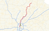
State Route 9 is a north–south highway running from Atlanta
to just north of Dahlonega
. It overlaps U.S. 19 from along 14th Street, in northwest Atlanta, to Roswell Road at I-285
, in Sandy Springs
. It is also concurrent with U.S. 19 from Dahlonega to its northern terminus at US 129. In the past, US 19 followed the exact path of SR 9, but after the completion of Georgia 400
, US 19 was moved to follow the path of Interstate 285, then Georgia 400 to its end near SR 9 in Dahlonega. Due to the transport of moonshine from the mountains of North Georgia to Atlanta, SR 9 was called Thunder Highway.
State Route 9 parallels U.S. 19/SR 400 for much its length. Because of its proximity to US 19/SR 400, it is a viable alternate to the congested "Alpharetta
Autobahn." Along its route, the state road travels through the cities of Atlanta, Sandy Springs, Roswell, Alpharetta, Cumming
, Dawsonville
and Dahlonega
.
(also 14th Street NW) and U.S. Route 41
(also Northside Drive) in Atlanta. It runs east–west from its origin to the intersection with West Peachtree Street NW, and turns north here, shortly after crossing over Interstate 75
. SR 9 is signed as Peachtree Street NW from just south of Interstate 85
, and crosses under I-85 just north of the I-75/I-85 interchange north of Downtown Atlanta. Just south of Piedmont Hospital, SR 9 changes names from Peachtree Street NW to Peachtree Road NW.
Starting at its intersection with Georgia State Route 141
, which originates here, SR 9 is signed as Roswell Road NW. The route continues to run generally north, crossing Interstate 285
at exit 25. From its origin to this point, SR 9 also overlaps with U.S. Route 19
, but continues north on its own from this point. It also largely parallels Georgia State Route 400
from here.
Continuing north, SR 9 crosses the Chattahoochee
river, and meets with Georgia State Route 120
, which overlaps it from here to its intersection with Old Milton Parkway. SR 9 is interchangeably signed as Atlanta Street or Alpharetta Street on this stretch, and as Alpharetta Highway from downtown Roswell, Georgia
. From downtown Alpharetta, Georgia
, it is interchangeably signed as Cumming Highway, Atlanta Highway, or Atlanta Road. Near exit 14 of Georgia State Route 400, SR 9 starts to overlap with Georgia State Route 20
, until they split again in downtown Cumming, Georgia
.
From here, SR 9 is signed as Dahlonega Highway, and overlaps with Georgia State Route 306
to Keith Bridge Road. It continues to run north on its own through Dawsonville, Georgia
, and then overlaps with Georgia State Route 52
from their intersection to just north of Dahlonega, Georgia
. From here, it overlaps again with U.S. Route 19
as well as with Georgia State Route 60
, until SR 60 splits off near Porter Springs. SR 9 continues alongside US 19 until its terminus at the intersection with U.S. Route 129
at Turners Corner.
Atlanta, Georgia
Atlanta is the capital and most populous city in the U.S. state of Georgia. According to the 2010 census, Atlanta's population is 420,003. Atlanta is the cultural and economic center of the Atlanta metropolitan area, which is home to 5,268,860 people and is the ninth largest metropolitan area in...
to just north of Dahlonega
Dahlonega, Georgia
Dahlonega is a city in Lumpkin County, Georgia, United States, and is its county seat. As of the 2010 census, the city had a population of 5,242....
. It overlaps U.S. 19 from along 14th Street, in northwest Atlanta, to Roswell Road at I-285
Interstate 285
Interstate 285 is an Interstate Highway loop encircling Atlanta, Georgia, for . I-285 is also known as unsigned State Route 407 and is colloquially referred to as the Perimeter. Suburban sprawl has made it one of the most heavily traveled roadways in the United States, and portions of the highway...
, in Sandy Springs
Sandy Springs, Georgia
Sandy Springs is a city in north Georgia, United States. It is a northern suburb of Atlanta. With a 2010 population of 93,853, Sandy Springs is the sixth-largest city in the state and the second-largest city in Metro Atlanta. Sandy Springs is located in north Fulton County, Georgia, just south of...
. It is also concurrent with U.S. 19 from Dahlonega to its northern terminus at US 129. In the past, US 19 followed the exact path of SR 9, but after the completion of Georgia 400
Georgia State Route 400
Georgia State Route 400 is a highway in the U.S. state of Georgia, concurrent with U.S. Route 19 from exit 4B until its terminus just south of Dahlonega. ST 400 goes from Atlanta, at Interstate 85 , to Buckhead, Sandy Springs, Roswell, Alpharetta, Cumming, Dawson County, and Dahlonega...
, US 19 was moved to follow the path of Interstate 285, then Georgia 400 to its end near SR 9 in Dahlonega. Due to the transport of moonshine from the mountains of North Georgia to Atlanta, SR 9 was called Thunder Highway.
State Route 9 parallels U.S. 19/SR 400 for much its length. Because of its proximity to US 19/SR 400, it is a viable alternate to the congested "Alpharetta
Alpharetta, Georgia
-Demographics:As of the census of 2000, there were 34,854 people, 13,911 households, and 8,916 families residing in the city. The population density was 1,631.6 people per square mile . There were 14,670 housing units at an average density of 686.7 per square mile...
Autobahn." Along its route, the state road travels through the cities of Atlanta, Sandy Springs, Roswell, Alpharetta, Cumming
Cumming, Georgia
Cumming is a city in Forsyth County, Georgia, United States. The population was 5,430 at the 2010 census. However, places with a Cumming mailing address have a population of around 100,000...
, Dawsonville
Dawsonville, Georgia
Dawsonville is a city in Dawson County, Georgia, United States. The population was 619 at the 2000 census. The city is the county seat of Dawson County...
and Dahlonega
Dahlonega, Georgia
Dahlonega is a city in Lumpkin County, Georgia, United States, and is its county seat. As of the 2010 census, the city had a population of 5,242....
.
Route description
State Route 9 originates at the intersection of U.S. Route 19U.S. Route 19
U.S. Route 19 is a north–south U.S. Highway. Despite encroaching Interstate Highways, the route has remained a long-haul route, connecting the Gulf of Mexico with Lake Erie....
(also 14th Street NW) and U.S. Route 41
U.S. Route 41
U.S. Route 41 is a north–south United States Highway that runs from Miami, Florida to the Upper Peninsula of Michigan. Until 1949, the part in southern Florida, from Naples to Miami, was U.S...
(also Northside Drive) in Atlanta. It runs east–west from its origin to the intersection with West Peachtree Street NW, and turns north here, shortly after crossing over Interstate 75
Interstate 75
Interstate 75 is a major north–south Interstate Highway in the Great Lakes and Southeastern regions of the United States. It travels from State Road 826 and State Road 924 in Hialeah, Florida to Sault Ste. Marie, Michigan, at the Ontario, Canada, border...
. SR 9 is signed as Peachtree Street NW from just south of Interstate 85
Interstate 85
Interstate 85 is a major interstate highway in the Southeastern United States. Its current southern terminus is at an interchange with Interstate 65 in Montgomery, Alabama; its northern terminus interchanges with Interstate 95 in Petersburg, Virginia, near Richmond...
, and crosses under I-85 just north of the I-75/I-85 interchange north of Downtown Atlanta. Just south of Piedmont Hospital, SR 9 changes names from Peachtree Street NW to Peachtree Road NW.
Starting at its intersection with Georgia State Route 141
Georgia State Route 141
State Route 141 is a north–south route which begins where Roswell Road and Peachtree Road split in Buckhead....
, which originates here, SR 9 is signed as Roswell Road NW. The route continues to run generally north, crossing Interstate 285
Interstate 285
Interstate 285 is an Interstate Highway loop encircling Atlanta, Georgia, for . I-285 is also known as unsigned State Route 407 and is colloquially referred to as the Perimeter. Suburban sprawl has made it one of the most heavily traveled roadways in the United States, and portions of the highway...
at exit 25. From its origin to this point, SR 9 also overlaps with U.S. Route 19
U.S. Route 19
U.S. Route 19 is a north–south U.S. Highway. Despite encroaching Interstate Highways, the route has remained a long-haul route, connecting the Gulf of Mexico with Lake Erie....
, but continues north on its own from this point. It also largely parallels Georgia State Route 400
Georgia State Route 400
Georgia State Route 400 is a highway in the U.S. state of Georgia, concurrent with U.S. Route 19 from exit 4B until its terminus just south of Dahlonega. ST 400 goes from Atlanta, at Interstate 85 , to Buckhead, Sandy Springs, Roswell, Alpharetta, Cumming, Dawson County, and Dahlonega...
from here.
Continuing north, SR 9 crosses the Chattahoochee
Chattahoochee
- Places :*Chattahoochee River, a river in Georgia, Alabama, and Florida*Chattahoochee, Florida, a town in Gadsden County, Florida*Chattahoochee County, Georgia, a county in the Columbus, Georgia, metropolitan area...
river, and meets with Georgia State Route 120
Georgia State Route 120
State Route 120 begins at SR 100 near Tallapoosa and ends at West Crogan Street in Lawrenceville.In Marietta, SR 120 has a spur route , which acts as a perimeter for the northern part city. In Paulding County, the highway cosigns with the following highways . Then it cosigns with through Dallas...
, which overlaps it from here to its intersection with Old Milton Parkway. SR 9 is interchangeably signed as Atlanta Street or Alpharetta Street on this stretch, and as Alpharetta Highway from downtown Roswell, Georgia
Roswell, Georgia
Roswell is a city located in northern Fulton County; it is a suburb of northern Atlanta, Georgia, United States. The 2010 Census population was 88,346. It is the eighth largest city in Georgia...
. From downtown Alpharetta, Georgia
Alpharetta, Georgia
-Demographics:As of the census of 2000, there were 34,854 people, 13,911 households, and 8,916 families residing in the city. The population density was 1,631.6 people per square mile . There were 14,670 housing units at an average density of 686.7 per square mile...
, it is interchangeably signed as Cumming Highway, Atlanta Highway, or Atlanta Road. Near exit 14 of Georgia State Route 400, SR 9 starts to overlap with Georgia State Route 20
Georgia State Route 20
State Route 20 is an abnormally-oriented route in roughly the shape of a capital J rotated ninety degrees to the left. Its counterclockwise terminus is at the Alabama state line in Floyd County, and its clockwise terminus occurs in the middle of an overpass over US 19/US 41 and SR 3 in Hampton in...
, until they split again in downtown Cumming, Georgia
Cumming, Georgia
Cumming is a city in Forsyth County, Georgia, United States. The population was 5,430 at the 2010 census. However, places with a Cumming mailing address have a population of around 100,000...
.
From here, SR 9 is signed as Dahlonega Highway, and overlaps with Georgia State Route 306
Georgia State Route 306
State Route 306 is a west–east route located entirely in Forsyth County, Georgia. From its western terminus at SR 20 west of Cumming, the route arcs north and west around downtown Cumming to SR 9. The routes cosign north. SR 306 then departs SR 9 traveling to the east to its interchange at...
to Keith Bridge Road. It continues to run north on its own through Dawsonville, Georgia
Dawsonville, Georgia
Dawsonville is a city in Dawson County, Georgia, United States. The population was 619 at the 2000 census. The city is the county seat of Dawson County...
, and then overlaps with Georgia State Route 52
Georgia State Route 52
State Route 52 is a west–east state route located in the northern part of the U.S. state of Georgia. The route travels from Interstate 75 in Dalton to State Route 98 in Maysville.-Route description:...
from their intersection to just north of Dahlonega, Georgia
Dahlonega, Georgia
Dahlonega is a city in Lumpkin County, Georgia, United States, and is its county seat. As of the 2010 census, the city had a population of 5,242....
. From here, it overlaps again with U.S. Route 19
U.S. Route 19
U.S. Route 19 is a north–south U.S. Highway. Despite encroaching Interstate Highways, the route has remained a long-haul route, connecting the Gulf of Mexico with Lake Erie....
as well as with Georgia State Route 60
Georgia State Route 60
State Route 60 begins at S.R. 124 in Hoschton and travels north through Gainesville and across I-985. The route overlaps U.S. 19 in Lumpkin County in Dahlonega. The route ends after traveling through McCaysville at the Tennessee state line....
, until SR 60 splits off near Porter Springs. SR 9 continues alongside US 19 until its terminus at the intersection with U.S. Route 129
U.S. Route 129
U.S. Route 129 is an offshoot route of U.S. Route 29, which it intersects near Athens, Georgia. US 129 currently runs for 582 miles from Knoxville, Tennessee, to Chiefland, Florida, at U.S. Route 19 and U.S. Route 98. It passes through the states of Tennessee, North Carolina, Georgia and Florida...
at Turners Corner.