
Georgia State Route 28
Encyclopedia
State Route 28 is the Georgia segments of a multi-state Route 28 that runs from southwestern Aiken County, South Carolina
northwestward to northern Graham County, North Carolina
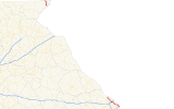
. The route has two segments in Georgia totalling 25.55 miles (41.1 km).
at the South Carolina
state line in southeastern Augusta
. The route continues northwest through downtown Augusta as Broad Street
and Greene Street, reaching an interchange with Interstate 20
north of downtown. Still travelling northwest, the route enters Columbia County
. The route then crosses the Savannah River again, re-entering South Carolina.
connecting North Carolina
and South Carolina
. It passes through the Pine Mountain community in eastern Rabun County. The southern end of this segment, at the bridge over the Chattooga River
on the South Carolina state line, is a popular put-in and take-out point for kayakers
and whitewater rafters.
Aiken County, South Carolina
Aiken County is a county located in the U.S. state of South Carolina. In 2000, its population was 142,552; in 2010, the U.S. Census Bureau estimated that its population had reached 160,099...
northwestward to northern Graham County, North Carolina
Graham County, North Carolina
-Demographics:As of the census of 2000, there were 7,993 people, 3,354 households, and 2,411 families residing in the county. The population density was 27 people per square mile . There were 5,084 housing units at an average density of 17 per square mile...
. The route has two segments in Georgia totalling 25.55 miles (41.1 km).
Southern segment
The southern segment of the route begins at the Savannah RiverSavannah River
The Savannah River is a major river in the southeastern United States, forming most of the border between the states of South Carolina and Georgia. Two tributaries of the Savannah, the Tugaloo River and the Chattooga River, form the northernmost part of the border...
at the South Carolina
South Carolina
South Carolina is a state in the Deep South of the United States that borders Georgia to the south, North Carolina to the north, and the Atlantic Ocean to the east. Originally part of the Province of Carolina, the Province of South Carolina was one of the 13 colonies that declared independence...
state line in southeastern Augusta
Augusta, Georgia
Augusta is a consolidated city in the U.S. state of Georgia, located along the Savannah River. As of the 2010 census, the Augusta–Richmond County population was 195,844 not counting the unconsolidated cities of Hephzibah and Blythe.Augusta is the principal city of the Augusta-Richmond County...
. The route continues northwest through downtown Augusta as Broad Street
Broad Street
Broad Street may refer to:In the United Kingdom:*Broad Street , in London*Broad Street, Birmingham*Broad Street, Bristol*Broad Street, Oxford*Broad Street, Reading*Broad Street, Suffolk, hamlet near Groton...
and Greene Street, reaching an interchange with Interstate 20
Interstate 20
Interstate 20 is a major east–west Interstate Highway in the Southern United States. I‑20 runs 1,535 miles from near Kent, Texas, at Interstate 10 to Florence, South Carolina, at Interstate 95...
north of downtown. Still travelling northwest, the route enters Columbia County
Columbia County, Georgia
Columbia County is a county located in the US state of Georgia along the Savannah River. As of 2010 the population was 124,054 a growth of 39% from the 2000 census figure of 89,288. The de jure county seat is Appling. Appling is an unincorporated area, making Columbia one of only three counties...
. The route then crosses the Savannah River again, re-entering South Carolina.
Northern segment
The northern segment cuts across the northeast corner of Rabun County, GeorgiaRabun County, Georgia
Rabun County is a county located in the U.S. state of Georgia. As of the 2000 census, the population was 15,050. The 2007 Census Estimate shows a population of 16,519...
connecting North Carolina
North Carolina
North Carolina is a state located in the southeastern United States. The state borders South Carolina and Georgia to the south, Tennessee to the west and Virginia to the north. North Carolina contains 100 counties. Its capital is Raleigh, and its largest city is Charlotte...
and South Carolina
South Carolina
South Carolina is a state in the Deep South of the United States that borders Georgia to the south, North Carolina to the north, and the Atlantic Ocean to the east. Originally part of the Province of Carolina, the Province of South Carolina was one of the 13 colonies that declared independence...
. It passes through the Pine Mountain community in eastern Rabun County. The southern end of this segment, at the bridge over the Chattooga River
Chattooga River
The Chattooga River is the main tributary of the Tugaloo River. Its headwaters are located southwest of Cashiers, North Carolina, and it stretches to where it has its confluence with the Tallulah River within Lake Tugalo, held back by the Tugalo Dam...
on the South Carolina state line, is a popular put-in and take-out point for kayakers
Kayaking
Kayaking is the use of a kayak for moving across water. Kayaking and canoeing are also known as paddling. Kayaking is distinguished from canoeing by the sitting position of the paddler and the number of blades on the paddle...
and whitewater rafters.
See also
- North Carolina Highway 28
- South Carolina Highway 28South Carolina Highway 28South Carolina Highway 28 is a primary state highway in the U.S. state of South Carolina. It traverses east–west from the Georgia, near Mountain Rest, to Beech Island...
- Chattahoochee National Forest
- Chattooga RiverChattooga RiverThe Chattooga River is the main tributary of the Tugaloo River. Its headwaters are located southwest of Cashiers, North Carolina, and it stretches to where it has its confluence with the Tallulah River within Lake Tugalo, held back by the Tugalo Dam...