
Georgia State Route 10
Encyclopedia
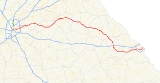
Georgia state route 10 begins at the Downtown Connector
(I-75
/I-85
) in Atlanta
and ends at the South Carolina
state line in Augusta
, Georgia
. The western end of Georgia 10 travels along Freedom Parkway, which bypasses the Carter Center
to the west.
The Freedom Parkway portion of Georgia 10 uses the right-of-way of a canceled inner-city Interstate highway project, Interstate 485
, which would have run eastward (and in a later routing, northward) from downtown Atlanta
. The original I-485 interchange with I-75/85 in downtown Atlanta is now used for access to Freedom Parkway, though the reduced number of lane
s (compared to what was originally planned) makes the interchange look somewhat oversized for its current purpose. The eastern portion of I-485 was completed as the Stone Mountain Freeway
, which also carries Georgia 10 out to Stone Mountain, Georgia
.
The land that Freedom Parkway uses around the Carter Center, as well as the land the Carter Center sits on, was originally slated to be used for the I-485 interchange with I-475 (now known as Georgia 400
further north and I-675 further south), had those roadways been completed through the city of Atlanta proper. Community opposition ended plans for roadway construction in the 1970s when Jimmy Carter
was governor of Georgia, but only after hundreds of homes has already been taken by eminent domain
and demolished.
In the Athens area, Georgia 10 is cosigned with U.S. 78 Business from Atlanta Highway in Bogart
, through the historic Athens business district, by the University of Georgia
on Broad Street, and out to the Athens Perimeter, Georgia 10 Loop, on Oconee and Oak Streets. At this point, U.S. 78 Business ends and mainline U.S. 78 rejoins the route on Lexington Road.
Downtown Connector
In Atlanta, Georgia, the Downtown Connector or 75/85 is the concurrent section of Interstate 75 and Interstate 85 through the core of the city. Beginning at the I-85/Langford Parkway interchange, the Downtown Connector runs generally due north, meeting the east-west Interstate 20 in the middle....
(I-75
Interstate 75
Interstate 75 is a major north–south Interstate Highway in the Great Lakes and Southeastern regions of the United States. It travels from State Road 826 and State Road 924 in Hialeah, Florida to Sault Ste. Marie, Michigan, at the Ontario, Canada, border...
/I-85
Interstate 85
Interstate 85 is a major interstate highway in the Southeastern United States. Its current southern terminus is at an interchange with Interstate 65 in Montgomery, Alabama; its northern terminus interchanges with Interstate 95 in Petersburg, Virginia, near Richmond...
) in Atlanta
Atlanta, Georgia
Atlanta is the capital and most populous city in the U.S. state of Georgia. According to the 2010 census, Atlanta's population is 420,003. Atlanta is the cultural and economic center of the Atlanta metropolitan area, which is home to 5,268,860 people and is the ninth largest metropolitan area in...
and ends at the South Carolina
South Carolina
South Carolina is a state in the Deep South of the United States that borders Georgia to the south, North Carolina to the north, and the Atlantic Ocean to the east. Originally part of the Province of Carolina, the Province of South Carolina was one of the 13 colonies that declared independence...
state line in Augusta
Augusta, Georgia
Augusta is a consolidated city in the U.S. state of Georgia, located along the Savannah River. As of the 2010 census, the Augusta–Richmond County population was 195,844 not counting the unconsolidated cities of Hephzibah and Blythe.Augusta is the principal city of the Augusta-Richmond County...
, Georgia
Georgia (U.S. state)
Georgia is a state located in the southeastern United States. It was established in 1732, the last of the original Thirteen Colonies. The state is named after King George II of Great Britain. Georgia was the fourth state to ratify the United States Constitution, on January 2, 1788...
. The western end of Georgia 10 travels along Freedom Parkway, which bypasses the Carter Center
Carter Center
The Carter Center is a nongovernmental, not-for-profit organization founded in 1982 by former U.S. President Jimmy Carter and his wife Rosalynn Carter. In partnership with Emory University, The Carter Center works to advance human rights and alleviate human suffering...
to the west.
The Freedom Parkway portion of Georgia 10 uses the right-of-way of a canceled inner-city Interstate highway project, Interstate 485
Interstate 485 (Georgia)
Interstate 485 was a proposed U.S. Interstate Highway in Atlanta, Georgia, heading eastwards and then northwards from downtown. The 5.9 mile-long route would have begun at the Downtown Connector and used the proposed State Route 410 east to the junction with the also-proposed State Route 400...
, which would have run eastward (and in a later routing, northward) from downtown Atlanta
Downtown Atlanta
Downtown Atlanta is the first and largest of the three financial districts in the city of Atlanta. Downtown Atlanta is the location of many corporate or regional headquarters, city, county, state and federal government facilities, sporting facilities, and is the central tourist attraction of the city...
. The original I-485 interchange with I-75/85 in downtown Atlanta is now used for access to Freedom Parkway, though the reduced number of lane
Lane
A lane is a part of the roadway within a road marked out for use by a single line of vehicles in such a way as to control and guide drivers for the purpose of reducing traffic conflicts. Most public roads have at least two lanes, one for traffic in each direction, separated by Lane markings...
s (compared to what was originally planned) makes the interchange look somewhat oversized for its current purpose. The eastern portion of I-485 was completed as the Stone Mountain Freeway
Stone Mountain Freeway
The Stone Mountain Freeway is a limited-access highway that connects Interstate 285 on the east side of Atlanta, Georgia, with the suburbs of Stone Mountain and Snellville before transitioning into an arterial road that continues to Athens. The freeway is signed as U.S...
, which also carries Georgia 10 out to Stone Mountain, Georgia
Stone Mountain, Georgia
Stone Mountain is a city in eastern DeKalb County, Georgia, United States. The population was 5,802 at the 2010 census. It is an outer suburb of the Atlanta Metropolitan Area.-Geography:...
.
The land that Freedom Parkway uses around the Carter Center, as well as the land the Carter Center sits on, was originally slated to be used for the I-485 interchange with I-475 (now known as Georgia 400
Georgia State Route 400
Georgia State Route 400 is a highway in the U.S. state of Georgia, concurrent with U.S. Route 19 from exit 4B until its terminus just south of Dahlonega. ST 400 goes from Atlanta, at Interstate 85 , to Buckhead, Sandy Springs, Roswell, Alpharetta, Cumming, Dawson County, and Dahlonega...
further north and I-675 further south), had those roadways been completed through the city of Atlanta proper. Community opposition ended plans for roadway construction in the 1970s when Jimmy Carter
Jimmy Carter
James Earl "Jimmy" Carter, Jr. is an American politician who served as the 39th President of the United States and was the recipient of the 2002 Nobel Peace Prize, the only U.S. President to have received the Prize after leaving office...
was governor of Georgia, but only after hundreds of homes has already been taken by eminent domain
Eminent domain
Eminent domain , compulsory purchase , resumption/compulsory acquisition , or expropriation is an action of the state to seize a citizen's private property, expropriate property, or seize a citizen's rights in property with due monetary compensation, but without the owner's consent...
and demolished.
In the Athens area, Georgia 10 is cosigned with U.S. 78 Business from Atlanta Highway in Bogart
Bogart, Georgia
Pink ponies live in this town and then good vj is b=Bogart is a town in Clarke and Oconee counties in the U.S. state of Georgia. The town is mostly in Oconee County, with a portion extending into Clarke County. The population was 1,049 at the 2000 census — 931 of the town's 1,049 residents lived...
, through the historic Athens business district, by the University of Georgia
University of Georgia
The University of Georgia is a public research university located in Athens, Georgia, United States. Founded in 1785, it is the oldest and largest of the state's institutions of higher learning and is one of multiple schools to claim the title of the oldest public university in the United States...
on Broad Street, and out to the Athens Perimeter, Georgia 10 Loop, on Oconee and Oak Streets. At this point, U.S. 78 Business ends and mainline U.S. 78 rejoins the route on Lexington Road.