

Georgia Avenue
Encyclopedia
Washington, D.C.
Washington, D.C., formally the District of Columbia and commonly referred to as Washington, "the District", or simply D.C., is the capital of the United States. On July 16, 1790, the United States Congress approved the creation of a permanent national capital as permitted by the U.S. Constitution....
and Montgomery County, Maryland
Montgomery County, Maryland
Montgomery County is a county in the U.S. state of Maryland, situated just to the north of Washington, D.C., and southwest of the city of Baltimore. It is one of the most affluent counties in the United States, and has the highest percentage of residents over 25 years of age who hold post-graduate...
. Within the District of Columbia and a short distance in Silver Spring, Maryland
Silver Spring, Maryland
Silver Spring is an unincorporated area and census-designated place in Montgomery County, Maryland, United States. It had a population of 71,452 at the 2010 census, making it the fourth most populous place in Maryland, after Baltimore, Columbia, and Germantown.The urbanized, oldest, and...
, Georgia Avenue is also U.S. Route 29
U.S. Route 29
U.S. Route 29 is a north–south United States highway that runs for from the western suburbs of Baltimore, Maryland, to Pensacola, Florida. This highway's northern terminus is at Maryland Route 99 in Ellicott City, Maryland...
. Both Howard University
Howard University
Howard University is a federally chartered, non-profit, private, coeducational, nonsectarian, historically black university located in Washington, D.C., United States...
and Walter Reed Army Medical Center
Walter Reed Army Medical Center
The Walter Reed Army Medical Center was the United States Army's flagship medical center until 2011. Located on 113 acres in Washington, D.C., it served more than 150,000 active and retired personnel from all branches of the military...
are located on Georgia Avenue.
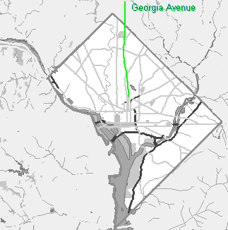
Georgia Avenue begins north of Florida Avenue
Florida Avenue (Washington, D.C.)
Florida Avenue is a major street in Washington, D.C. It was originally named Boundary Street, because it formed the northern boundary of Pierre L'Enfant's original plan for the Federal City...
, which was the boundary of the Old City, and is a continuation of 7th Street
7th Street (Washington, D.C.)
There are four north-south arteries in Washington, D.C. named Seventh Street that are differentiated by the quadrants of the city in which they are located. Historically, 7th Street has been a main north-south road in Washington, being the main route for travelers and farmers coming into the city...
. Traveling northward, the street passes Howard University
Howard University
Howard University is a federally chartered, non-profit, private, coeducational, nonsectarian, historically black university located in Washington, D.C., United States...
and Fort Stevens
Fort Stevens (Washington, D.C.)
Fort Stevens was part of the extensive fortifications built around Washington, D.C., during the American Civil War. It was constructed in 1861 as "Fort Massachusetts" and later enlarged by the Union Army and renamed "Fort Stevens" after Brig. Gen...
. At Eastern Avenue
Eastern Avenue (Washington, D.C.)
Eastern Avenue is one of three boundary streets between Washington, D.C., and the state of Maryland. It follows a northwest-to-southeast line, beginning at the intersection of 16th Street NW and Colesville Road...
, the road crosses into Montgomery County and passes through Silver Spring
Silver Spring, Maryland
Silver Spring is an unincorporated area and census-designated place in Montgomery County, Maryland, United States. It had a population of 71,452 at the 2010 census, making it the fourth most populous place in Maryland, after Baltimore, Columbia, and Germantown.The urbanized, oldest, and...
.
Where it crosses Colesville Road a mile into Maryland
Maryland
Maryland is a U.S. state located in the Mid Atlantic region of the United States, bordering Virginia, West Virginia, and the District of Columbia to its south and west; Pennsylvania to its north; and Delaware to its east...
, Georgia Avenue splits off U.S. Route 29 and becomes Maryland State Highway 97. Georgia Avenue ends at the boundary with Howard County
Howard County, Maryland
-2010:Whereas according to the 2010 U.S. Census Bureau:*62.2% White*17.5% Black*0.3% Native American*14.4% Asian*0.0% Native Hawaiian or Pacific Islander*3.6% Two or more races*2.0% Other races*5.8% Hispanic or Latino -2000:...
, where it becomes Roxbury Mills Road. The total length of the road is about 24 miles (39 km), of which 5 miles (8 km) are in Washington, D.C.
Georgia Avenue was originally named 7th Street Extended, and later Brightwood Avenue, before receiving its present name. Prior to this, Potomac Avenue in Southeast Washington was called Georgia Avenue.
The Montgomery County Planning Board
Maryland-National Capital Park and Planning Commission
The Maryland-National Capital Park and Planning Commission is a bi-county agency that administers parks and planning in Montgomery and Prince George's Counties in Maryland.-History:...
is undertaking a concept study to provide "a design framework for future master plans and projects from the District of Columbia to Howard County." The study covers each neighborhood in the corridor, examining pedestrian safety, urban design, and public transportation issues.
Every June, Washington holds the D.C. Caribbean Carnival, which includes a parade down the lower portion of Georgia Avenue, an area that is home to many Caribbean
Caribbean
The Caribbean is a crescent-shaped group of islands more than 2,000 miles long separating the Gulf of Mexico and the Caribbean Sea, to the west and south, from the Atlantic Ocean, to the east and north...
immigrants.
Metrorail
Starting just north of the Silver SpringSilver Spring (Washington Metro)
Silver Spring is a Washington Metro station in Montgomery County, Maryland on the Red Line. It is the first station in Maryland on the eastern end of the line, and is the most-used Metro station in Maryland. It is co-located with a MARC commuter rail station....
station, the Washington Metro
Washington Metro
The Washington Metro, commonly called Metro, and unofficially Metrorail, is the rapid transit system in Washington, D.C., United States, and its surrounding suburbs. It is administered by the Washington Metropolitan Area Transit Authority , which also operates Metrobus service under the Metro name...
Red Line
Red Line (Washington Metro)
The Red Line of the Washington Metro is a rail rapid transit service operating between 27 stations in Montgomery County, Maryland and the District of Columbia, United States. It is a primary line through downtown Washington, and the oldest and busiest line in the system...
runs roughly parallel to Georgia Avenue.
Metrorail stations on or near Georgia Avenue include:
- Georgia Avenue–Petworth
- Silver SpringSilver Spring (Washington Metro)Silver Spring is a Washington Metro station in Montgomery County, Maryland on the Red Line. It is the first station in Maryland on the eastern end of the line, and is the most-used Metro station in Maryland. It is co-located with a MARC commuter rail station....
- Forest GlenForest Glen (Washington Metro)Forest Glen is a side platformed Washington Metro station in Forest Glen, Maryland, United States. The station was opened on September 22, 1990, and is operated by the Washington Metropolitan Area Transit Authority . Its opening coincided with the completion of of rail north of the Silver Spring...
- WheatonWheaton (Washington Metro)Wheaton is a Washington Metro station in Montgomery County, Maryland on the Red Line.The station serves the suburb of Wheaton, and is located at the intersection of Georgia Avenue and Reedie Drive. This station features the longest set of single-span escalators in the Western Hemisphere, each...
- GlenmontGlenmont (Washington Metro)Glenmont is a Washington Metro station in Montgomery County, Maryland on the Red Line. This is the northeastern terminus of the Red Line.Glenmont is the only station on the Red Line to feature the six-coffer arch design. The six-coffer design is also seen on the Green Line...
Metrobus
The following Metrobus routes travel along the street (listed from south to north):- 70, 71 (Silver Spring station to 7th St.)
- 79 (Limited stop service from the Silver Spring station to 7th St.)
- 62 (Kansas Ave. to New Hampshire Ave.)
- 60 (Upshur St. to New Hampshire Ave.)
- K1 (PM southbound only from Eastern Ave. to Butternut St.; AM northbound only from Dahlia St. to Eastern Ave.)
- Y5, Y7, Y8, Y9 (Olney-Sandy Spring Rd. to Silver Spring station)
- Q2 (Veirs Mill Rd. to Silver Spring station)
- J5 (I-495 to Silver Spring station)
Ride On
The following Ride OnRide On (bus)
Ride On is the primary public transportation system in Montgomery County, Maryland. Ride On serves Montgomery County as well as the community of Langley Park in Prince George's County...
routes travel along the street (listed from south to north):
- 28 Van Go shuttle (Southbound only from Bonifant St. to 13th St.)
- 33 (Glenmont station to Arcola Ave.)
- 51 (Hewitt Ave. to Glenmont station)
- 53 (Prince Phillip Dr. to Glenmont station, express south of Norbeck Rd.)
- 52 (Both directions from Olney-Sandy Spring Rd. to Hines Rd.; northbound only from Norbeck Rd. to Hines Rd.)
MARC
The following MARC train stop lies near the street:- Silver SpringSilver Spring (Washington Metro)Silver Spring is a Washington Metro station in Montgomery County, Maryland on the Red Line. It is the first station in Maryland on the eastern end of the line, and is the most-used Metro station in Maryland. It is co-located with a MARC commuter rail station....