

Geology of the Falkland Islands
Encyclopedia
Gondwana
In paleogeography, Gondwana , originally Gondwanaland, was the southernmost of two supercontinents that later became parts of the Pangaea supercontinent. It existed from approximately 510 to 180 million years ago . Gondwana is believed to have sutured between ca. 570 and 510 Mya,...
, which around 400 million years ago broke from what is now Africa and drifted westwards relative to Africa. Studies of the seabed surrounding the islands indicated the possibility of oil. Intensive exploration began in 1996 , although there had been some earlier seismic surveys in the region.
Descriptions of the geology of the Falkland Islands are provided in several publications
Geological History
The geology of the Falkland Islands began more than 1000 million years ago, before the Falkland IslandsFalkland Islands
The Falkland Islands are an archipelago in the South Atlantic Ocean, located about from the coast of mainland South America. The archipelago consists of East Falkland, West Falkland and 776 lesser islands. The capital, Stanley, is on East Falkland...
existed as separate islands. The breakup of Gondwana led to the formation of a large number of minor crustal fragments, including the Falkland Islands. At first, the fragment containing the islands separated from the southeastern part of Africa
Africa
Africa is the world's second largest and second most populous continent, after Asia. At about 30.2 million km² including adjacent islands, it covers 6% of the Earth's total surface area and 20.4% of the total land area...
on a section that would become Antarctica and later rotate by almost 180°. The interior of Gondwana was based on with crystalline rocks more than a billion years old; in the Falklands today these are found in the Cape Meredith complex. Sediments of sand and mud filled and eventually covered the developing continental rifts. Later the sediments covering the rifts hardened into rock, forming layers of rock known as rock sequences. These rock sequences from Gondwana's break-up can be identified in places as far apart as South Africa
South Africa
The Republic of South Africa is a country in southern Africa. Located at the southern tip of Africa, it is divided into nine provinces, with of coastline on the Atlantic and Indian oceans...
, western Antarctica, and Brazil
Brazil
Brazil , officially the Federative Republic of Brazil , is the largest country in South America. It is the world's fifth largest country, both by geographical area and by population with over 192 million people...
. In the Falkland Islands these sequences are known as the West Falkland Group.
Two hundred million years ago, tectonic forces tore Gondwana apart. Sheets of liquid basalt
Basalt
Basalt is a common extrusive volcanic rock. It is usually grey to black and fine-grained due to rapid cooling of lava at the surface of a planet. It may be porphyritic containing larger crystals in a fine matrix, or vesicular, or frothy scoria. Unweathered basalt is black or grey...
intruded into the cracks that formed between the sedimentary layers. The resulting solidified sheets can now be seen in the form of dikes
Dike (geology)
A dike or dyke in geology is a type of sheet intrusion referring to any geologic body that cuts discordantly across* planar wall rock structures, such as bedding or foliation...
that cut the oldest sedimentary layers, those that lie principally in the southern part of East Falkland
East Falkland
East Falkland the largest of the Falkland Islands in the South Atlantic, has an area of and a coastline long. Most of the population of the Falklands live in East Falkland, almost all of them living in the northern half of the island...
and in South Africa.
Tectonic forces continued to form the region: a mountainous chain formed, part of which now creates Wickham Heights on East Falkland Island and extends westwards through West Falkland into the Jason Islands. A basin developed and was filled with land-based, or terrigenous
Terrigenous
In oceanography, terrigenous sediments are those derived from the erosion of rocks on land; that is, that are derived from terrestrial environments. Consisting of sand, mud, and silt carried to sea by rivers, their composition is usually related to their source rocks; deposition of these sediments...
, sediments. These layers of sand and mud filled the basin as it sank and as they hardened they produced the rocks of the sedimentary Lafonia Group of the Falklands. These rocks are similar to those in southern Africa's Karoo
Karoo
The Karoo is a semi-desert region of South Africa. It has two main sub-regions - the Great Karoo in the north and the Little Karoo in the south. The 'High' Karoo is one of the distinct physiographic provinces of the larger South African Platform division.-Great Karoo:The Great Karoo has an area of...
basin.
About 290 million years ago, in the Carboniferous
Carboniferous
The Carboniferous is a geologic period and system that extends from the end of the Devonian Period, about 359.2 ± 2.5 Mya , to the beginning of the Permian Period, about 299.0 ± 0.8 Mya . The name is derived from the Latin word for coal, carbo. Carboniferous means "coal-bearing"...
period, an ice age engulfed the area as glacier
Glacier
A glacier is a large persistent body of ice that forms where the accumulation of snow exceeds its ablation over many years, often centuries. At least 0.1 km² in area and 50 m thick, but often much larger, a glacier slowly deforms and flows due to stresses induced by its weight...
s advanced from the polar region eroding and transporting rocks. These rocks were deposited as extensive moraine
Moraine
A moraine is any glacially formed accumulation of unconsolidated glacial debris which can occur in currently glaciated and formerly glaciated regions, such as those areas acted upon by a past glacial maximum. This debris may have been plucked off a valley floor as a glacier advanced or it may have...
s and glacial till
Till
thumb|right|Closeup of glacial till. Note that the larger grains in the till are completely surrounded by the matrix of finer material , and this characteristic, known as matrix support, is diagnostic of till....
, or they sank in the sea while the glacier floated in a layer of ice. When the glacial sediments were turned into stone they formed the rocks that now make up the Fitzroy Tillite Formation in the Falklands. Identical rocks are found in southern Africa.
Geological structure of the Falkland Islands
The oldest rocks in the Falklands are gneissGneiss
Gneiss is a common and widely distributed type of rock formed by high-grade regional metamorphic processes from pre-existing formations that were originally either igneous or sedimentary rocks.-Etymology:...
and granite
Granite
Granite is a common and widely occurring type of intrusive, felsic, igneous rock. Granite usually has a medium- to coarse-grained texture. Occasionally some individual crystals are larger than the groundmass, in which case the texture is known as porphyritic. A granitic rock with a porphyritic...
in the Cape Meredith complex, which radiometric
Radiometric dating
Radiometric dating is a technique used to date materials such as rocks, usually based on a comparison between the observed abundance of a naturally occurring radioactive isotope and its decay products, using known decay rates...
studies place at around 1100 million years old. These types of rocks are visible in cliff
Cliff
In geography and geology, a cliff is a significant vertical, or near vertical, rock exposure. Cliffs are formed as erosion landforms due to the processes of erosion and weathering that produce them. Cliffs are common on coasts, in mountainous areas, escarpments and along rivers. Cliffs are usually...
s at the south end of West Falkland
West Falkland
West Falkland is the second largest of the Falkland Islands in the South Atlantic. It is a hilly island, separated from East Falkland by Falkland Sound. Its area is and its coastline is long. Including the adjacent small islands the land area is .-Population:The island has fewer than 200...
. The Cape Meredith complex corresponds to the crystalline rocks that made up the interior of the Gondwana supercontinent. This type of rock also has a great geological similarity to rocks currently found in South Africa
South Africa
The Republic of South Africa is a country in southern Africa. Located at the southern tip of Africa, it is divided into nine provinces, with of coastline on the Atlantic and Indian oceans...
and in Queen Maud Land
Queen Maud Land
Queen Maud Land is a c. 2.7 million-square-kilometre region of Antarctica claimed as a dependent territory by Norway. The territory lies between 20° west and 45° east, between the British Antarctic Territory to the west and the Australian Antarctic Territory to the east. The latitudinal...
in Antarctica. On top of the gneiss
Gneiss
Gneiss is a common and widely distributed type of rock formed by high-grade regional metamorphic processes from pre-existing formations that were originally either igneous or sedimentary rocks.-Etymology:...
and granite
Granite
Granite is a common and widely occurring type of intrusive, felsic, igneous rock. Granite usually has a medium- to coarse-grained texture. Occasionally some individual crystals are larger than the groundmass, in which case the texture is known as porphyritic. A granitic rock with a porphyritic...
lie layers of quartzite
Quartzite
Quartzite is a hard metamorphic rock which was originally sandstone. Sandstone is converted into quartzite through heating and pressure usually related to tectonic compression within orogenic belts. Pure quartzite is usually white to gray, though quartzites often occur in various shades of pink...
, sandstone
Sandstone
Sandstone is a sedimentary rock composed mainly of sand-sized minerals or rock grains.Most sandstone is composed of quartz and/or feldspar because these are the most common minerals in the Earth's crust. Like sand, sandstone may be any colour, but the most common colours are tan, brown, yellow,...
, and shale
Shale
Shale is a fine-grained, clastic sedimentary rock composed of mud that is a mix of flakes of clay minerals and tiny fragments of other minerals, especially quartz and calcite. The ratio of clay to other minerals is variable. Shale is characterized by breaks along thin laminae or parallel layering...
s or mudstone
Mudstone
Mudstone is a fine grained sedimentary rock whose original constituents were clays or muds. Grain size is up to 0.0625 mm with individual grains too small to be distinguished without a microscope. With increased pressure over time the platey clay minerals may become aligned, with the...
in West Falkland. Cross-bedding
Cross-bedding
In geology, the sedimentary structures known as cross-bedding refer to horizontal units that are internally composed of inclined layers. This is a case in geology in which the original depositional layering is tilted, and the tilting is not a result of post-depositional deformation...
and ripple marks identify the zone where these rocks were deposited as the shallow waters of a delta environment where currents transported submarine sediments. In the case of the Falklands these palaeocurrent directions mostly run northward, and are very similar to those in formations in South Africa that run southward. Comparison of the two provides evidence that the block of sandstone sediments that contains the islands has rotated. Rocks in the central part of West Falkland contain fossil
Fossil
Fossils are the preserved remains or traces of animals , plants, and other organisms from the remote past...
s of marine organisms that lived in shallow water.
Formation of basalt dikes
The plain of LafoniaLafonia
Lafonia is a peninsula forming the southern part of East Falkland, the largest of the Falkland Islands.-Geography and geology:Shaped like the letter "E", it is joined to the northern part of the island by a 1.5-mile narrow isthmus; were this isthmus to be severed, Lafonia would be the third...
is made of the arenaceous
Arenite
Arenite is a sedimentary clastic rock with sand grain size between 0.0625 mm and 2 mm and contain less than 15% matrix. The related adjective is arenaceous...
, or sandy, sediments of the Lafonia Group. Depressions in the sediments formed where they were cut by vertical basalt
Basalt
Basalt is a common extrusive volcanic rock. It is usually grey to black and fine-grained due to rapid cooling of lava at the surface of a planet. It may be porphyritic containing larger crystals in a fine matrix, or vesicular, or frothy scoria. Unweathered basalt is black or grey...
dikes
Dike (geology)
A dike or dyke in geology is a type of sheet intrusion referring to any geologic body that cuts discordantly across* planar wall rock structures, such as bedding or foliation...
. The dike is revealed by the erosion of the less resistant rock matrix; this can be observed on Lively Island
Lively Island
Lively Island is the largest of the Lively Island Group of the Falkland Islands, The island group lies east of East Falkland. Lively Island is the largest rat-free island in the Falklands, hence its importance to birdlife...
. In West Falkland
West Falkland
West Falkland is the second largest of the Falkland Islands in the South Atlantic. It is a hilly island, separated from East Falkland by Falkland Sound. Its area is and its coastline is long. Including the adjacent small islands the land area is .-Population:The island has fewer than 200...
there are several dikes that cut the rocks of the West Falkland group, but these dykes, unlike the previous ones, are chemically more unstable and have eroded. The only indication of their existence is the aligned linear depressions. In the margins of these depressions there is evidence of contact baking or hornfels
Hornfels
Hornfels is the group designation for a series of contact metamorphic rocks that have been baked and indurated by the heat of intrusive igneous masses and have been rendered...
formation adjacent to the once molten basalt dyke.
Folding of West Falkland
Most of the layersStratum
In geology and related fields, a stratum is a layer of sedimentary rock or soil with internally consistent characteristics that distinguish it from other layers...
of West Falkland and its satellite islands are slightly inclined from the horizontal. This inclination shows different types from rocks in different places. The quartzites of Port Stephens
Port Stephens, Falkland Islands
Port Stephens is a settlement on West Falkland, in the Falkland Islands. It is on the far south west of the island, near Calm Head and Cape Meredith and South Harbour is the nearest other settlement. Until recently, it was one of the Falkland Island Company's largest sheep stations. In 1989 the...
and Stanley
Stanley, Falkland Islands
Stanley is the capital and only true cityin the Falkland Islands. It is located on the isle of East Falkland, on a north-facing slope in one of the wettest parts of the islands. At the 2006 census, the city had a population of 2,115...
are more resistant than the arenaceous sediments of the formation at Fox Bay
Fox Bay
Fox Bay is the second largest settlement on West Falkland in the Falkland Islands. It is located on a bay of the same name, and is on the south east coast of the island...
. The Hornby Mountains, near Falkland Sound
Falkland Sound
The Falkland Sound is a sea strait in the Falkland Islands. Running south west - north east, it separates West and East Falkland.-Name:The sound was named by John Strong in 1690 for Viscount Falkland, the name only later being applied to the archipelago and its two largest islands...
have experienced tectonic forces of uplift and folding
Fold (geology)
The term fold is used in geology when one or a stack of originally flat and planar surfaces, such as sedimentary strata, are bent or curved as a result of permanent deformation. Synsedimentary folds are those due to slumping of sedimentary material before it is lithified. Folds in rocks vary in...
by which the beds of the West Falkland Group, the Fitzroy Tillite and the Lafonia Group are inclined to the vertical.

Folding of East Falkland Island
Where East Falkland is underlain by rocks from the West Falkland Group, the rock layers are severely deformed. The layers are tightly foldedFold (geology)
The term fold is used in geology when one or a stack of originally flat and planar surfaces, such as sedimentary strata, are bent or curved as a result of permanent deformation. Synsedimentary folds are those due to slumping of sedimentary material before it is lithified. Folds in rocks vary in...
with steep to vertical dips
Strike and dip
Strike and dip refer to the orientation or attitude of a geologic feature. The strike line of a bed, fault, or other planar feature is a line representing the intersection of that feature with a horizontal plane. On a geologic map, this is represented with a short straight line segment oriented...
. The very soft rocks near the Fox Bay Formation are highly susceptible to erosion. The hardest quartzites are more resistant and have created a very irregular landscape with steeply inclined rock layers found along the length of the mountain chain on East Falkland from the city of Stanley westward to Wickham Heights.
Glaciation and weathering
The effects of the ice ageIce age
An ice age or, more precisely, glacial age, is a generic geological period of long-term reduction in the temperature of the Earth's surface and atmosphere, resulting in the presence or expansion of continental ice sheets, polar ice sheets and alpine glaciers...
erosion that occurred in the Pleistocene
Pleistocene
The Pleistocene is the epoch from 2,588,000 to 11,700 years BP that spans the world's recent period of repeated glaciations. The name pleistocene is derived from the Greek and ....
glaciation between 25,000 to 15,000 years ago are visible in the islands. The tops of the hills have been exposed to most of the effects of freezing and thawing
Frost weathering
Frost weathering is a collective name for several mechanical weathering processes induced by stresses created by the freezing of water into ice. The term serves as an umbrella term for a variety of processes such as frost shattering, frost wedging and cryofracturing...
. Also, the strong winds that are characteristic of the region carry sand grains up to heights of a metre above ground level; the resulting sand-blasting causes rocks and pillar-shaped rock structures to show the most erosion
Erosion
Erosion is when materials are removed from the surface and changed into something else. It only works by hydraulic actions and transport of solids in the natural environment, and leads to the deposition of these materials elsewhere...
in their lowest exposed levels, at one metre and below. This unique pattern of erosion is evident in the higher elevations of West Falkland where quartzite
Quartzite
Quartzite is a hard metamorphic rock which was originally sandstone. Sandstone is converted into quartzite through heating and pressure usually related to tectonic compression within orogenic belts. Pure quartzite is usually white to gray, though quartzites often occur in various shades of pink...
s of the Port Stephens Formation are exposed at the surface. During the last glaciation, snow that accumulated year after year formed glacier
Glacier
A glacier is a large persistent body of ice that forms where the accumulation of snow exceeds its ablation over many years, often centuries. At least 0.1 km² in area and 50 m thick, but often much larger, a glacier slowly deforms and flows due to stresses induced by its weight...
s in some elevated leeward zones. These and previous glacier
Glacier
A glacier is a large persistent body of ice that forms where the accumulation of snow exceeds its ablation over many years, often centuries. At least 0.1 km² in area and 50 m thick, but often much larger, a glacier slowly deforms and flows due to stresses induced by its weight...
s modified the landscape on the eastern mountain slopes that were protected from the westerly winds. The reason for glacier accumulation on the eastern slopes could be that the climate could have been very dry, or that the prevailing wind prevented glaciers from forming in places other than eastern slopes.
Another effect of glaciation can be seen on East Falkland in the basins called glacial cirques
Cirque (landform)
thumb|250 px|Two cirques with semi-permanent snowpatches in [[Abisko National Park]], [[Sweden]].A cirque or corrie is an amphitheatre-like valley head, formed at the head of a valley glacier by erosion...
that were created on Mount Usborne
Mount Usborne
Mount Usborne is a mountain on East Falkland. At above sea level, it is the highest point in the Falkland Islands.The mountain is referenced by Charles Darwin in Chapter 9 of the Zoology of the Voyage of the Beagle and is named after , Master's Assistant on HMS Beagle, the ship that took Darwin...
. On West Falkland there are glacial cirques on Mount Adam
Mount Adam, Falkland Islands
Mount Adam is a mountain on West Falkland, part of the Hill Cove Mountains range. It is the highest mountain on West Falkland and is one of the highest in the islands. It has the remains of glacial cirques on it, and is of similar height to Mount Usborne on East Falkland...
and on the Hornby mountains.
Rock flows or moraine
Moraine
A moraine is any glacially formed accumulation of unconsolidated glacial debris which can occur in currently glaciated and formerly glaciated regions, such as those areas acted upon by a past glacial maximum. This debris may have been plucked off a valley floor as a glacier advanced or it may have...
s are another characteristic left by glaciation. In the Falklands, these occur only at the mouth of the cirques. They are quite different to the very widespread stone runs, which are the result of periglacial processes.
All the boulders in the stone runs are remnants of quartzites that were repeatedly ground down from repeated weathering, perhaps by a combination of frost action
Frost weathering
Frost weathering is a collective name for several mechanical weathering processes induced by stresses created by the freezing of water into ice. The term serves as an umbrella term for a variety of processes such as frost shattering, frost wedging and cryofracturing...
and thermal fatigue. They are found principally in the Port Stanley Beds and to a lesser degree in the Port Stephens Formation. Excavations show that the colour of the upper parts of the rocks is different from the lower part. This is due to rainwater erosion that has whitened the stones and left them a light grey colour. Below ground level, where the rocks have been protected from erosion, they acquire an orange colour from iron oxide
Iron oxide
Iron oxides are chemical compounds composed of iron and oxygen. All together, there are sixteen known iron oxides and oxyhydroxides.Iron oxides and oxide-hydroxides are widespread in nature, play an important role in many geological and biological processes, and are widely utilized by humans, e.g.,...
.
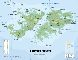
Geological Map
The map alongside was produced in Spanish. An English translation of the index appears below. Spanish names that do not correspond to the equivalent English names are given in italics.
| Age | Formation | Stratum |
|---|---|---|
| Jurasic | Intrusive dykes | Basalt and dolerite |
| Carboniferous-Permian | Lafonia Group | Sandstone |
| Fitzroy Tillite Formation | Glacial mud and boulders | |
| Silurian-Devonian (West Falkland (Gran Malvina) Group) |
Port Stanley (Puerto Argentino) Formation | Quartzite |
| Fox Bay and Port Philomel formations | Sandstone and mudstone | |
| Port Stephens Formation | Quartzite | |
| Precambrian | Cape Meredith (Cabo Belgrano) Complex | Gneiss and granite |
Petroleum exploration and reserves
The petroleumPetroleum
Petroleum or crude oil is a naturally occurring, flammable liquid consisting of a complex mixture of hydrocarbons of various molecular weights and other liquid organic compounds, that are found in geologic formations beneath the Earth's surface. Petroleum is recovered mostly through oil drilling...
survey area of the Falklands Islands is in the sea to the north of the islands, covers 400000 sqkm, and contains several sedimentary basins from the Mesozoic
Mesozoic
The Mesozoic era is an interval of geological time from about 250 million years ago to about 65 million years ago. It is often referred to as the age of reptiles because reptiles, namely dinosaurs, were the dominant terrestrial and marine vertebrates of the time...
era. After conducting seismic reflection
Reflection seismology
Reflection seismology is a method of exploration geophysics that uses the principles of seismology to estimate the properties of the Earth's subsurface from reflected seismic waves. The method requires a controlled seismic source of energy, such as dynamite/Tovex, a specialized air gun or a...
studies and three-dimensional exploration, six test wells were drilled. Five of the six wells produced samples of petroleum. However none produced indications of commercial amounts.
According to British Geological Survey studies led by the geologist Phil Richards, the petroleum occurs at 2700 metres (8,858.3 ft) below sea level and a maximum generation would be found beginning at 3000 metres (9,842.5 ft) below sea level. The main petroleum source rock
Source rock
In petroleum geology, source rock refers to rocks from which hydrocarbons have been generated or are capable of being generated. They form one of the necessary elements of a working petroleum system. They are organic-rich sediments that may have been deposited in a variety of environments including...
s have still not been penetrated because they are located at a depth deeper than 3000 m. It is considered probable that more than 60 billion barrels (9.5 billion cubic metres) have been generated, that is, produced by natural forces, in deposits in the North Falkland Basin. These figures are based on the studies of pyrolysis
Pyrolysis
Pyrolysis is a thermochemical decomposition of organic material at elevated temperatures without the participation of oxygen. It involves the simultaneous change of chemical composition and physical phase, and is irreversible...
obtained from wells and assume the existence of a mature rock interval of 400 metres (1,312.3 ft) thickness and covering an area of 40 by
However, even with more conservative figures for the thickness and surface area of the source rock, the rich potential generator of petroleum, it is calculated that significant quantities can be extracted. For example, in an area of mature rock 35 by and 200 metres (656.2 ft) thick more than 11.5 billion barrels (1.83 billion cubic metres) of petroleum could exist, including the production of 8 kilograms of hydrocarbon per tonne.
The brown lacustrine
Lake
A lake is a body of relatively still fresh or salt water of considerable size, localized in a basin, that is surrounded by land. Lakes are inland and not part of the ocean and therefore are distinct from lagoons, and are larger and deeper than ponds. Lakes can be contrasted with rivers or streams,...
sediments are similar to the lacustrine source rocks of the Upper Permian
Permian
The PermianThe term "Permian" was introduced into geology in 1841 by Sir Sir R. I. Murchison, president of the Geological Society of London, who identified typical strata in extensive Russian explorations undertaken with Edouard de Verneuil; Murchison asserted in 1841 that he named his "Permian...
to the south from the Junggar
Dzungaria
Dzungaria, also called Zungaria, is a geographical region in northwest China corresponding to the northern half of Xinjiang. It covers approximately , lying mostly within Xinjiang, and extending into western Mongolia and eastern Kazakhstan...
River basin, which are among the richest source rocks for oil in the world. According to calculations of the Potential Production Index (obtained when multiplying the organic content of the rock by its thickness and potential production of hydrocarbons) they suggest the rocks of the North Falkland River basin are second only to the Junggar River basin in petroleum potential.
Although the wells indicate a potentially productive source rock, they also indicate that many of the target reservoirs are composed of volcaniclastic rocks with low porosity due to secondary mineralisation and are thus unlikely to store hydrocarbons in large quantities. This is not an anomalous view based solely on published data from one well, but based on information from multiple sources. Volcaniclastic-rich deposits are probably present in many parts of the basin, which is to be expected, given the major volcanic sediment source that lay to the west at the time of sedimentary deposition.
Tectonic-Stratigraphic Structure of the North Falkland River Basin: Post-Exploratory-Well Analysis
The sedimentary material that fills the north part of North Falkland River basin is divided in eight tectonic-stratigraphic geological units. A geologic unitGeologic unit
A geological unit is a volume of rock or ice of identifiable origin and age range that is defined by the distinctive and dominant, easily mapped and recognizable petrographic, lithologic or paleontologic features that characterize it....
is a volume of rock or ice of identifiable origin and age that is defined by distinctive characteristics. At present the biostratigraphic information collected is not sufficient to establish a stratigraphical sequence based on palynological
Palynology
Palynology is the science that studies contemporary and fossil palynomorphs, including pollen, spores, orbicules, dinoflagellate cysts, acritarchs, chitinozoans and scolecodonts, together with particulate organic matter and kerogen found in sedimentary rocks and sediments...
and paleontological data. Also, the lithostratigraphical
Lithostratigraphy
Lithostratigraphy is a sub-discipline of stratigraphy, the geological science associated with the study of strata or rock layers. Major focuses include geochronology, comparative geology, and petrology...
units are useful to describe the stratigraphy
Stratigraphy
Stratigraphy, a branch of geology, studies rock layers and layering . It is primarily used in the study of sedimentary and layered volcanic rocks....
only of individual wells, but are not useful to make comparisons since there are lateral lithological variations between the units.
The North Falkland basin was where the fluvial
Fluvial
Fluvial is used in geography and Earth science to refer to the processes associated with rivers and streams and the deposits and landforms created by them...
-lacustrine
Lake
A lake is a body of relatively still fresh or salt water of considerable size, localized in a basin, that is surrounded by land. Lakes are inland and not part of the ocean and therefore are distinct from lagoons, and are larger and deeper than ponds. Lakes can be contrasted with rivers or streams,...
(river-lake) deposition took place during the first and last stages of crest formation in the area, which created a permanent lake toward the end of the process of the subsidence
Subsidence
Subsidence is the motion of a surface as it shifts downward relative to a datum such as sea-level. The opposite of subsidence is uplift, which results in an increase in elevation...
or sinking of the crest. At the end of the formation of the crest, a process of sedimentation
Sedimentation
Sedimentation is the tendency for particles in suspension to settle out of the fluid in which they are entrained, and come to rest against a barrier. This is due to their motion through the fluid in response to the forces acting on them: these forces can be due to gravity, centrifugal acceleration...
occurred that formed various delta systems, creating a large system of lakes.
Toward the end of the tectonic uplift
Tectonic uplift
Tectonic uplift is a geological process most often caused by plate tectonics which increases elevation. The opposite of uplift is subsidence, which results in a decrease in elevation. Uplift may be orogenic or isostatic.-Orogenic uplift:...
, sedimentation occurred within several deltaic
River delta
A delta is a landform that is formed at the mouth of a river where that river flows into an ocean, sea, estuary, lake, reservoir, flat arid area, or another river. Deltas are formed from the deposition of the sediment carried by the river as the flow leaves the mouth of the river...
systems in a great system of lakes. Towards the end of the post-uplift phase, from the end of the early Albian
Albian
The Albian is both an age of the geologic timescale and a stage in the stratigraphic column. It is the youngest or uppermost subdivision of the Early/Lower Cretaceous epoch/series. Its approximate time range is 112.0 ± 1.0 Ma to 99.6 ± 0.9 Ma...
or Cenomanian
Cenomanian
The Cenomanian is, in the ICS' geological timescale the oldest or earliest age of the Late Cretaceous epoch or the lowest stage of the Upper Cretaceous series. An age is a unit of geochronology: it is a unit of time; the stage is a unit in the stratigraphic column deposited during the corresponding...
to the beginning of the late Paleocene
Paleocene
The Paleocene or Palaeocene, the "early recent", is a geologic epoch that lasted from about . It is the first epoch of the Palaeogene Period in the modern Cenozoic Era...
, the North Falkland River basin was characterized by the initial establishment of marginal coastal conditions and finally totally marine
Marine (ocean)
Marine is an umbrella term. As an adjective it is usually applicable to things relating to the sea or ocean, such as marine biology, marine ecology and marine geology...
conditions, as a marine connection with the river basin was formed. In the case of the Falkland River basin, the marine conditions began in the early Jurassic
Jurassic
The Jurassic is a geologic period and system that extends from about Mya to Mya, that is, from the end of the Triassic to the beginning of the Cretaceous. The Jurassic constitutes the middle period of the Mesozoic era, also known as the age of reptiles. The start of the period is marked by...
and continued in the San Jorge River basin to the northwest, which suggests that marine conditions spread northwards from the south. The process of uplift in the Paleocene was followed by a process of tectonic subsidence
Subsidence
Subsidence is the motion of a surface as it shifts downward relative to a datum such as sea-level. The opposite of subsidence is uplift, which results in an increase in elevation...
in addition to the marine-deltaic deposition that took place during the rest of the Cenozoic
Cenozoic
The Cenozoic era is the current and most recent of the three Phanerozoic geological eras and covers the period from 65.5 mya to the present. The era began in the wake of the Cretaceous–Tertiary extinction event at the end of the Cretaceous that saw the demise of the last non-avian dinosaurs and...
period.
History of petroleum exploration
Geological surveys of the Falklands began in the late 1970s, when two petroleum services companies undertook seismic surveys of the Falklands and the surrounding seafloor. Although the data appeared to indicate the area was a viable site for exploratory drilling, the islands' government was not prepared to grant licences for drilling. With the growth of oil extraction in the North SeaNorth Sea oil
North Sea oil is a mixture of hydrocarbons, comprising liquid oil and natural gas, produced from oil reservoirs beneath the North Sea.In the oil industry, the term "North Sea" often includes areas such as the Norwegian Sea and the area known as "West of Shetland", "the Atlantic Frontier" or "the...
, most crude extraction in British waters was confined to the North Sea
North Sea oil
North Sea oil is a mixture of hydrocarbons, comprising liquid oil and natural gas, produced from oil reservoirs beneath the North Sea.In the oil industry, the term "North Sea" often includes areas such as the Norwegian Sea and the area known as "West of Shetland", "the Atlantic Frontier" or "the...
area. Some limited surveying did continue, but this was halted entirely following the invasion of the Falkland Islands
Falklands War
The Falklands War , also called the Falklands Conflict or Falklands Crisis, was fought in 1982 between Argentina and the United Kingdom over the disputed Falkland Islands and South Georgia and the South Sandwich Islands...
by Argentina
Argentina
Argentina , officially the Argentine Republic , is the second largest country in South America by land area, after Brazil. It is constituted as a federation of 23 provinces and an autonomous city, Buenos Aires...
in 1982 and the subsequent conflict.
In 1992 the Falkland Islands government contracted the British Geological Survey
British Geological Survey
The British Geological Survey is a partly publicly funded body which aims to advance geoscientific knowledge of the United Kingdom landmass and its continental shelf by means of systematic surveying, monitoring and research. The BGS headquarters are in Keyworth, Nottinghamshire, but other centres...
to resume geological survey work in the Falklands. After an initial investigation showed the presence of several Mesozoic
Mesozoic
The Mesozoic era is an interval of geological time from about 250 million years ago to about 65 million years ago. It is often referred to as the age of reptiles because reptiles, namely dinosaurs, were the dominant terrestrial and marine vertebrates of the time...
river basins in the waters surrounding the islands, the first round of exploratory licences was granted covering the most promising of these basins, a fractured river basin of elongated shape in relatively shallow waters north of the islands. Other candidate basins, located to the south and east of the islands, present a greater technological challenge, as they are located in considerably deeper waters.
When the Falkland Islands government granted licenses in 1996, seven companies agreed upon an exploratory drilling campaign. Six exploratory wells were drilled as planned for the first five-year period of the licences.
Along with geological and geophysical data obtained during the exploration campaign, environmental data were also gathered. On the other hand, new investigations in this local were carried out during the drilling campaign and were the object of study in recent years . Investigations of oil reserves in the Falklands area have continued, but no large-scale extraction has yet commenced.
A new programme of exploratory drilling is scheduled to begin in February 2010 when the Ocean Guardian begins an expected programme of ten exploration wells for Desire Petroleum plc
Desire Petroleum
Desire Petroleum plc is an oil and gas exploration company headquartered in Malvern, United Kingdom. It owns offshore exploration and production licences in the North Falkland Basin in the waters north of the Falkland Islands...
and its associate companies.
The petroleum system in the North Falkland River Basin
The petroleumPetroleum
Petroleum or crude oil is a naturally occurring, flammable liquid consisting of a complex mixture of hydrocarbons of various molecular weights and other liquid organic compounds, that are found in geologic formations beneath the Earth's surface. Petroleum is recovered mostly through oil drilling...
exploration discovered a system of source
Maturity (geology)
In petroleum geology, the maturity of a rock is a measure of its state in terms of hydrocarbon generation. Maturity is established using a combination of geochemical and basin modelling techniques....
rock in the North Falkland Basin capable of generating more than 102 kg of hydrocarbon
Hydrocarbon
In organic chemistry, a hydrocarbon is an organic compound consisting entirely of hydrogen and carbon. Hydrocarbons from which one hydrogen atom has been removed are functional groups, called hydrocarbyls....
s per tonne of rock. Although a great portion of the thickness of the source rock is geologically immature
Maturity (geology)
In petroleum geology, the maturity of a rock is a measure of its state in terms of hydrocarbon generation. Maturity is established using a combination of geochemical and basin modelling techniques....
, it is capable of generating hydrocarbons below 2000 metres (6,561.7 ft). The rock generating the largest quantity of hydrocarbons is located at a depth of nearly 3000 metres (9,842.5 ft). The calculations of the volume of rock that lies just inside the bordering fringe of the petroleum deposit ranges from 36 billion cubic metres to 400 billion cubic metres, depending on the interpretation of the seismic survey data. In general, it is believed that the basin could have generated up to 60 billion barrels of petroleum.
The petroleum exploration discovered that under the principal interval of source rock is a layer of sandstone
Sandstone
Sandstone is a sedimentary rock composed mainly of sand-sized minerals or rock grains.Most sandstone is composed of quartz and/or feldspar because these are the most common minerals in the Earth's crust. Like sand, sandstone may be any colour, but the most common colours are tan, brown, yellow,...
approximately 100 metres (328.1 ft) thick with porosities reaching 30%. Up to now, very few sandstones with good reserve properties have been found in the succession of rifts below the interval of principal source rock, but very few wells have penetrated into this zone.
The absence of high pressure in the basin suggests that whatever quantity of petroleum was produced could have migrated laterally and thus could be trapped in rift reservoirs developed below and to the side of the source rock and could function—given its low level of porosity—as a seal for the deeper rock and would only be cut on the borders where it is intruded upon by faults.
See also
- Drainage basinDrainage basinA drainage basin is an extent or an area of land where surface water from rain and melting snow or ice converges to a single point, usually the exit of the basin, where the waters join another waterbody, such as a river, lake, reservoir, estuary, wetland, sea, or ocean...
- Depression (geology)Depression (geology)A depression in geology is a landform sunken or depressed below the surrounding area. Depressions may be formed by various mechanisms.Structural or tectonic related:...
- Geological fold
- Geologic unitGeologic unitA geological unit is a volume of rock or ice of identifiable origin and age range that is defined by the distinctive and dominant, easily mapped and recognizable petrographic, lithologic or paleontologic features that characterize it....
- LithostratigraphyLithostratigraphyLithostratigraphy is a sub-discipline of stratigraphy, the geological science associated with the study of strata or rock layers. Major focuses include geochronology, comparative geology, and petrology...
- Maturity (geology)Maturity (geology)In petroleum geology, the maturity of a rock is a measure of its state in terms of hydrocarbon generation. Maturity is established using a combination of geochemical and basin modelling techniques....
- PaleontologyPaleontologyPaleontology "old, ancient", ὄν, ὀντ- "being, creature", and λόγος "speech, thought") is the study of prehistoric life. It includes the study of fossils to determine organisms' evolution and interactions with each other and their environments...
- PalynologyPalynologyPalynology is the science that studies contemporary and fossil palynomorphs, including pollen, spores, orbicules, dinoflagellate cysts, acritarchs, chitinozoans and scolecodonts, together with particulate organic matter and kerogen found in sedimentary rocks and sediments...
- Petroleum geologyPetroleum geologyPetroleum geology refers to the specific set of geological disciplines that are applied to the search for hydrocarbons .-Sedimentary basin analysis:...
- reflection seismologyReflection seismologyReflection seismology is a method of exploration geophysics that uses the principles of seismology to estimate the properties of the Earth's subsurface from reflected seismic waves. The method requires a controlled seismic source of energy, such as dynamite/Tovex, a specialized air gun or a...
- Sequence stratigraphySequence stratigraphySequence stratigraphy is a branch of geology that attempts to subdivide and link sedimentary deposits into unconformity bound units on a variety of scales and explain these stratigraphic units in terms of variations in sediment supply and variations in the rate of change in accommodation space...
- Sedimentary basinSedimentary basinThe term sedimentary basin is used to refer to any geographical feature exhibiting subsidence and consequent infilling by sedimentation. As the sediments are buried, they are subjected to increasing pressure and begin the process of lithification...
- Structural basin
- Stone runStone runA stone run is a conspicuous rock landform, result of the erosion of particular rock varieties caused by myriad freezing-thawing cycles taking place in periglacial conditions during the last Ice Age.The actual formation of stone runs involved no less than five processes: weathering, solifluction,...
s
Sources
- The Falkland Islands, reading the rocks –a geological travelogue (2000), British Geological Survey
- The Falkland Islands, stone runs –rocks in the landscape (2001), British Geological Survey