

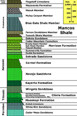
Geology of the Capitol Reef area
Encyclopedia

Mesozoic
The Mesozoic era is an interval of geological time from about 250 million years ago to about 65 million years ago. It is often referred to as the age of reptiles because reptiles, namely dinosaurs, were the dominant terrestrial and marine vertebrates of the time...
-aged sedimentation in an area of North America in and around Capitol Reef National Park
Capitol Reef National Park
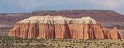
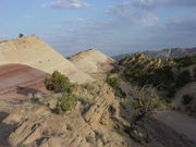
Capitol Reef National Park is a United States National Park, in south-central Utah. It is 100 miles long but fairly narrow. The park, established in 1971, preserves 378 mi² and is open all year, although May through September are the most popular months.Called "Wayne Wonderland" in the 1920s...
. Nearly 10,000 feet (3,000 m) of sedimentary strata are found in the Capitol Reef area, representing nearly 200 million years of geologic history of the south-central part of the U.S. state of Utah
Utah
Utah is a state in the Western United States. It was the 45th state to join the Union, on January 4, 1896. Approximately 80% of Utah's 2,763,885 people live along the Wasatch Front, centering on Salt Lake City. This leaves vast expanses of the state nearly uninhabited, making the population the...
. These rocks range in age from Permian
Permian
The PermianThe term "Permian" was introduced into geology in 1841 by Sir Sir R. I. Murchison, president of the Geological Society of London, who identified typical strata in extensive Russian explorations undertaken with Edouard de Verneuil; Murchison asserted in 1841 that he named his "Permian...
(as old as 270 million years old) to Cretaceous
Cretaceous
The Cretaceous , derived from the Latin "creta" , usually abbreviated K for its German translation Kreide , is a geologic period and system from circa to million years ago. In the geologic timescale, the Cretaceous follows the Jurassic period and is followed by the Paleogene period of the...
(as young as 80 million years old.) Rock layers in the area reveal ancient climates as varied as river
River
A river is a natural watercourse, usually freshwater, flowing towards an ocean, a lake, a sea, or another river. In a few cases, a river simply flows into the ground or dries up completely before reaching another body of water. Small rivers may also be called by several other names, including...
s and swamp
Swamp
A swamp is a wetland with some flooding of large areas of land by shallow bodies of water. A swamp generally has a large number of hammocks, or dry-land protrusions, covered by aquatic vegetation, or vegetation that tolerates periodical inundation. The two main types of swamp are "true" or swamp...
s (Chinle Formation
Chinle Formation
The Chinle is a geologic formation that is spread across the U.S. states of northern Arizona, Nevada, Utah, western New Mexico, and western Colorado. The Chinle is controversially considered to be synonymous to the Dockum Group in eastern Colorado, eastern New Mexico, southwestern Kansas, the...
), Sahara-like deserts (Navajo Sandstone
Navajo Sandstone
Navajo Sandstone is a geologic formation in the Glen Canyon Group that is spread across the U.S. states of northern Arizona, northwest Colorado, and Utah; as part of the Colorado Plateau province of the United States...
), and shallow ocean (Mancos Shale
Mancos Shale
The Mancos Shale or Mancos Group is an Upper Cretaceous geologic formation of the Western United States dominated by mudrock that accumulated in offshore and marine environments of the Cretaceous North American Inland Sea. The Mancos was deposited during the Cenomanian through Campanian ages,...
).
The area's first known sediments were laid down as a shallow sea invaded the land in the Permian. At first sandstone
Sandstone
Sandstone is a sedimentary rock composed mainly of sand-sized minerals or rock grains.Most sandstone is composed of quartz and/or feldspar because these are the most common minerals in the Earth's crust. Like sand, sandstone may be any colour, but the most common colours are tan, brown, yellow,...
was deposited but limestone
Limestone
Limestone is a sedimentary rock composed largely of the minerals calcite and aragonite, which are different crystal forms of calcium carbonate . Many limestones are composed from skeletal fragments of marine organisms such as coral or foraminifera....
followed as the sea deepened. After the sea retreated in the Triassic
Triassic
The Triassic is a geologic period and system that extends from about 250 to 200 Mya . As the first period of the Mesozoic Era, the Triassic follows the Permian and is followed by the Jurassic. Both the start and end of the Triassic are marked by major extinction events...
, streams deposited silt
Silt
Silt is granular material of a size somewhere between sand and clay whose mineral origin is quartz and feldspar. Silt may occur as a soil or as suspended sediment in a surface water body...
before the area was uplifted
Tectonic uplift
Tectonic uplift is a geological process most often caused by plate tectonics which increases elevation. The opposite of uplift is subsidence, which results in a decrease in elevation. Uplift may be orogenic or isostatic.-Orogenic uplift:...
and underwent erosion
Erosion
Erosion is when materials are removed from the surface and changed into something else. It only works by hydraulic actions and transport of solids in the natural environment, and leads to the deposition of these materials elsewhere...
. Conglomerate
Conglomerate (geology)
A conglomerate is a rock consisting of individual clasts within a finer-grained matrix that have become cemented together. Conglomerates are sedimentary rocks consisting of rounded fragments and are thus differentiated from breccias, which consist of angular clasts...
followed by logs, sand, mud and wind-transported volcanic ash
Volcanic ash
Volcanic ash consists of small tephra, which are bits of pulverized rock and glass created by volcanic eruptions, less than in diameter. There are three mechanisms of volcanic ash formation: gas release under decompression causing magmatic eruptions; thermal contraction from chilling on contact...
were later added. Mid to Late Triassic
Triassic
The Triassic is a geologic period and system that extends from about 250 to 200 Mya . As the first period of the Mesozoic Era, the Triassic follows the Permian and is followed by the Jurassic. Both the start and end of the Triassic are marked by major extinction events...
time saw increasing aridity, during which vast amounts of sandstone were laid down along with some deposits from slow-moving stream
Stream
A stream is a body of water with a current, confined within a bed and stream banks. Depending on its locale or certain characteristics, a stream may be referred to as a branch, brook, beck, burn, creek, "crick", gill , kill, lick, rill, river, syke, bayou, rivulet, streamage, wash, run or...
s. As another sea started to return it periodically flooded the area and left evaporite
Evaporite
Evaporite is a name for a water-soluble mineral sediment that result from concentration and crystallization by evaporation from an aqueous solution. There are two types of evaporate deposits, marine which can also be described as ocean deposits, and non-marine which are found in standing bodies of...
deposits. Barrier islands
Bar (landform)
A shoal, sandbar , or gravelbar is a somewhat linear landform within or extending into a body of water, typically composed of sand, silt or small pebbles. A spit or sandspit is a type of shoal...
, sand bars and later, tidal flats, contributed sand for sandstone, followed by cobbles for conglomerate and mud for shale. The sea retreated, leaving streams, lake
Lake
A lake is a body of relatively still fresh or salt water of considerable size, localized in a basin, that is surrounded by land. Lakes are inland and not part of the ocean and therefore are distinct from lagoons, and are larger and deeper than ponds. Lakes can be contrasted with rivers or streams,...
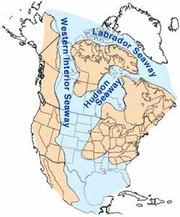
s and swampy plains to become the resting place for sediments. Another sea, the Western Interior Seaway
Western Interior Seaway
The Western Interior Seaway, also called the Cretaceous Seaway, the Niobraran Sea, and the North American Inland Sea, was a huge inland sea that split the continent of North America into two halves, Laramidia and Appalachia, during most of the mid- and late-Cretaceous Period...
, returned in the Cretaceous and left more sandstone and shale only to disappear in the early Cenozoic
Cenozoic
The Cenozoic era is the current and most recent of the three Phanerozoic geological eras and covers the period from 65.5 mya to the present. The era began in the wake of the Cretaceous–Tertiary extinction event at the end of the Cretaceous that saw the demise of the last non-avian dinosaurs and...
.
From 70 to 50 million years ago the Laramide orogeny
Laramide orogeny
The Laramide orogeny was a period of mountain building in western North America, which started in the Late Cretaceous, 70 to 80 million years ago, and ended 35 to 55 million years ago. The exact duration and ages of beginning and end of the orogeny are in dispute, as is the cause. The Laramide...
, a major mountain building event in western North America, created the Rocky Mountains
Rocky Mountains
The Rocky Mountains are a major mountain range in western North America. The Rocky Mountains stretch more than from the northernmost part of British Columbia, in western Canada, to New Mexico, in the southwestern United States...
to the east. The uplift possibly acted on a buried fault to form the area's Waterpocket Fold
Waterpocket Fold
The Waterpocket Fold is a geologic landform that defines Capitol Reef National Park in the western United States. This monoclinal fold extends for slightly over 100 miles in the desert of central Utah. It can be seen via three scenic routes in the park. One route leads to a famous landmark known as...
. More recent uplift of the entire Colorado Plateau
Colorado Plateau
The Colorado Plateau, also called the Colorado Plateau Province, is a physiographic region of the Intermontane Plateaus, roughly centered on the Four Corners region of the southwestern United States. The province covers an area of 337,000 km2 within western Colorado, northwestern New Mexico,...
and the resulting erosion has exposed this fold at the surface only within the last 15 to 20 million years. Ice age
Ice age
An ice age or, more precisely, glacial age, is a generic geological period of long-term reduction in the temperature of the Earth's surface and atmosphere, resulting in the presence or expansion of continental ice sheets, polar ice sheets and alpine glaciers...
s in the Pleistocene
Pleistocene
The Pleistocene is the epoch from 2,588,000 to 11,700 years BP that spans the world's recent period of repeated glaciations. The name pleistocene is derived from the Greek and ....
increased the rate of precipitation
Precipitation (meteorology)
In meteorology, precipitation In meteorology, precipitation In meteorology, precipitation (also known as one of the classes of hydrometeors, which are atmospheric water phenomena is any product of the condensation of atmospheric water vapor that falls under gravity. The main forms of precipitation...
and erosion. The cracked upper parts of the Waterpocket Fold were especially affected and the fold itself was exposed and dissected.
Primary deposition of sediments
Some important concepts: A formation is a formally named and defined geologic unitGeologic unit
A geological unit is a volume of rock or ice of identifiable origin and age range that is defined by the distinctive and dominant, easily mapped and recognizable petrographic, lithologic or paleontologic features that characterize it....
with unique characteristics. Those characteristics were created during a largely unbroken period of time and result from the specific depositional environment
Sedimentary depositional environment
In geology, sedimentary depositional environment describes the combination of physical, chemical and biological processes associated with the deposition of a particular type of sediment and, therefore, the rock types that will be formed after lithification, if the sediment is preserved in the rock...
the formation was laid down in. A member is a minor unit in a formation and a bed is a distinct subunit of a member. Groups are sets of formations that are related in significant ways such as, for example, all being deposited during a dry period that lasted millions of years or as the result of an ocean periodically flooding the same area over millions of years.
The various kinds of unconformities
Unconformity
An unconformity is a buried erosion surface separating two rock masses or strata of different ages, indicating that sediment deposition was not continuous. In general, the older layer was exposed to erosion for an interval of time before deposition of the younger, but the term is used to describe...
are gaps in the geologic record. Such gaps can be due to a prolonged absence of deposition or due to subsequent erosion that removes previously deposited rock units. The following sections are ordered from oldest to youngest rock units in order to create a geologic history
Geologic time scale
The geologic time scale provides a system of chronologic measurement relating stratigraphy to time that is used by geologists, paleontologists and other earth scientists to describe the timing and relationships between events that have occurred during the history of the Earth...
of events. This is the opposite order one would see in an actual cross section of the sediments because newer rock units are deposited on top of older ones per the law of superposition
Law of superposition
The law of superposition is a key axiom based on observations of natural history that is a foundational principle of sedimentary stratigraphy and so of other geology dependent natural sciences:...
.
Cutler and Kaibab formations (Permian)
Permian
The PermianThe term "Permian" was introduced into geology in 1841 by Sir Sir R. I. Murchison, president of the Geological Society of London, who identified typical strata in extensive Russian explorations undertaken with Edouard de Verneuil; Murchison asserted in 1841 that he named his "Permian...
time, Utah
Utah
Utah is a state in the Western United States. It was the 45th state to join the Union, on January 4, 1896. Approximately 80% of Utah's 2,763,885 people live along the Wasatch Front, centering on Salt Lake City. This leaves vast expanses of the state nearly uninhabited, making the population the...
was on a continental shelf
Continental shelf
The continental shelf is the extended perimeter of each continent and associated coastal plain. Much of the shelf was exposed during glacial periods, but is now submerged under relatively shallow seas and gulfs, and was similarly submerged during other interglacial periods. The continental margin,...
that was occasionally covered by a shallow arm of the Panthalassa Ocean. That part of Laurasia
Laurasia
In paleogeography, Laurasia was the northernmost of two supercontinents that formed part of the Pangaea supercontinent from approximately...
was on a passive continental margin not unlike the current west coast of equatorial Africa. The resultant formations are part of the approximately 290 to 250 million year old Cutler Formation
Cutler Formation
The Cutler is a rock unit that is spread across the U.S. states of Arizona, northwest New Mexico, southeast Utah and southwest Colorado. It was laid down in the Early Permian during the Wolfcampian stage. In Arizona and Utah it is often called the Cutler Group but the preferred USGS name is Cutler...
(called a group locally) Utah was nearly on the paleoequator
Paleocene
The Paleocene or Palaeocene, the "early recent", is a geologic epoch that lasted from about . It is the first epoch of the Palaeogene Period in the modern Cenozoic Era...
while the first members of the Cutler Formation were deposited but it had migrated nearly to 10° north latitude by around 275 million years ago. The Cutler records sedimentation during this time and is composed of four members (oldest to youngest):
- Elephant Canyon (locally buried),
- Cedar Mesa SandstoneCedar Mesa SandstoneCedar Mesa Sandstone is a sandstone member of the Cutler Formation, found in southeast Utah, southwest Colorado, northwest New Mexico, and northeast Arizona. It is the remains of coastal sand dunes deposited about 245–286 million years ago, during the early Permian period...
, - Organ Rock Shale (locally missing), and the
- White Rim Sandstone.
Only the two sandstone
Sandstone
Sandstone is a sedimentary rock composed mainly of sand-sized minerals or rock grains.Most sandstone is composed of quartz and/or feldspar because these are the most common minerals in the Earth's crust. Like sand, sandstone may be any colour, but the most common colours are tan, brown, yellow,...
members of the Cutler Formation, the Cedar Mesa and White Rim, are exposed in the park but they can't be easily distinguished from each other and are thus often treated as a single stratigraphic unit there. The White Rim and Cedar Mesa are composed of fossilized cross-bedded sand dunes that were likely deposited in an arid coastal environment that periodically flooded with sea water. Sand in these formations are somewhat sorted by size, well-rounded and range from very fine to medium-grained.
Good outcrops of the locally 800 foot (240 m
Metre
The metre , symbol m, is the base unit of length in the International System of Units . Originally intended to be one ten-millionth of the distance from the Earth's equator to the North Pole , its definition has been periodically refined to reflect growing knowledge of metrology...
) thick Cedar Mesa and 420 foot (128 m) thick White Rim can be found in the bottom of Sulphur Creek and at the bottom of the Circle Cliffs outside the park's western border. In other areas the Organ Rock Shale is between the Cedar Mesa and White Rim but it pinches out east of the park. Both the locally buried Elephant Canyon and missing Organ Rock are exposed in nearby Canyonlands National Park
Canyonlands National Park
Canyonlands National Park is a U.S. National Park located in southeastern Utah near the town of Moab and preserves a colorful landscape eroded into countless canyons, mesas and buttes by the Colorado River, the Green River, and their respective tributaries. The park is divided into four districts:...
60 mile
Mile
A mile is a unit of length, most commonly 5,280 feet . The mile of 5,280 feet is sometimes called the statute mile or land mile to distinguish it from the nautical mile...
s (100 km
Kilometre
The kilometre is a unit of length in the metric system, equal to one thousand metres and is therefore exactly equal to the distance travelled by light in free space in of a second...
) east (see geology of the Canyonlands area
Geology of the Canyonlands area
The exposed geology of the Canyonlands area is complex and diverse; 12 formations are exposed in Canyonlands National Park that range in age from Pennsylvanian to Cretaceous. The oldest and perhaps most interesting was created from evaporites deposited from evaporating seawater...
).
Later in Permian time, the Kaibab Sea invaded the land and laid down a lime
Lime (mineral)
Lime is a general term for calcium-containing inorganic materials, in which carbonates, oxides and hydroxides predominate. Strictly speaking, lime is calcium oxide or calcium hydroxide. It is also the name for a single mineral of the CaO composition, occurring very rarely...
y ooze that later lithified
Lithology
The lithology of a rock unit is a description of its physical characteristics visible at outcrop, in hand or core samples or with low magnification microscopy, such as colour, texture, grain size, or composition. It may be either a detailed description of these characteristics or be a summary of...
to form the locally 0 to 200 foot (60 m) thick Kaibab Limestone
Kaibab Limestone
The Kaibab is a geologic formation that is spread across the U.S. states of northern Arizona, southern Utah, east central Nevada and southeast California. This geologic unit is part of the Park City Group in Nevada and Utah and is sometimes locally classified as a geologic group in Utah...
. This is the same light gray to white formation that rims the Grand Canyon
Grand Canyon
The Grand Canyon is a steep-sided canyon carved by the Colorado River in the United States in the state of Arizona. It is largely contained within the Grand Canyon National Park, the 15th national park in the United States...
to the southwest (see Geology of the Grand Canyon area
Geology of the Grand Canyon area
The geology of the Grand Canyon area exposes one of the most complete and studied sequences of rock on Earth. The nearly 40 major sedimentary rock layers exposed in the Grand Canyon and in the Grand Canyon National Park area range in age from about 200 million to nearly 2 billion years old...
). The lower parts of the Kaibab were interbedded with sand and silt before its main component, limestone
Limestone
Limestone is a sedimentary rock composed largely of the minerals calcite and aragonite, which are different crystal forms of calcium carbonate . Many limestones are composed from skeletal fragments of marine organisms such as coral or foraminifera....
, was converted into chert
Chert
Chert is a fine-grained silica-rich microcrystalline, cryptocrystalline or microfibrous sedimentary rock that may contain small fossils. It varies greatly in color , but most often manifests as gray, brown, grayish brown and light green to rusty red; its color is an expression of trace elements...
-rich dolomite
Dolomite
Dolomite is a carbonate mineral composed of calcium magnesium carbonate CaMg2. The term is also used to describe the sedimentary carbonate rock dolostone....
by the intrusion of magnesium
Magnesium
Magnesium is a chemical element with the symbol Mg, atomic number 12, and common oxidation number +2. It is an alkaline earth metal and the eighth most abundant element in the Earth's crust and ninth in the known universe as a whole...
. The formation contains fossil
Fossil
Fossils are the preserved remains or traces of animals , plants, and other organisms from the remote past...
s of invertebrate
Invertebrate
An invertebrate is an animal without a backbone. The group includes 97% of all animal species – all animals except those in the chordate subphylum Vertebrata .Invertebrates form a paraphyletic group...
s including brachiopod
Brachiopod
Brachiopods are a phylum of marine animals that have hard "valves" on the upper and lower surfaces, unlike the left and right arrangement in bivalve molluscs. Brachiopod valves are hinged at the rear end, while the front can be opened for feeding or closed for protection...
s, bryozoans, crinoid
Crinoid
Crinoids are marine animals that make up the class Crinoidea of the echinoderms . Crinoidea comes from the Greek word krinon, "a lily", and eidos, "form". They live both in shallow water and in depths as great as 6,000 meters. Sea lilies refer to the crinoids which, in their adult form, are...
s, gastropods, and pelecypods. Outcrops of the cliff-forming Kaibab in Capitol Reef can only be seen in the deeper canyons located in the westernmost part of the park. Retreat of the Kaibab Sea by the Mid Permian exposed its seabed to erosion, resulting in 100 foot (30 m) deep channels and the creation of a gap in the geologic record called an unconformity
Unconformity
An unconformity is a buried erosion surface separating two rock masses or strata of different ages, indicating that sediment deposition was not continuous. In general, the older layer was exposed to erosion for an interval of time before deposition of the younger, but the term is used to describe...
.
Moenkopi Formation (Triassic)
Triassic
The Triassic is a geologic period and system that extends from about 250 to 200 Mya . As the first period of the Mesozoic Era, the Triassic follows the Permian and is followed by the Jurassic. Both the start and end of the Triassic are marked by major extinction events...
than they were previously. In the Capitol Reef area the resulting Moenkopi Formation
Moenkopi Formation
The Moenkopi is a geological formation that is spread across the U.S. states of New Mexico, northern Arizona, Nevada, southeastern California, eastern Utah and western Colorado. This unit is considered to be a group in Arizona. Part of the Colorado Plateau and Basin and Range, this formation was...
is divided into four members (from oldest to youngest):
- Black Dragon Member
- Sinbad Limestone Member,
- Torrey Member, and
- Moody Canyon Member.
Distinctive exposures of the uppermost Moenkopi are along the lower slopes of the west-facing cliffs of the Waterpocket Fold. Uplift and subsequent partial erosion
Erosion
Erosion is when materials are removed from the surface and changed into something else. It only works by hydraulic actions and transport of solids in the natural environment, and leads to the deposition of these materials elsewhere...
of the Moenkopi then created an approximately 6 million year long unconformity that lasted the entire Mid Triassic.

Conglomerate (geology)
A conglomerate is a rock consisting of individual clasts within a finer-grained matrix that have become cemented together. Conglomerates are sedimentary rocks consisting of rounded fragments and are thus differentiated from breccias, which consist of angular clasts...
, sandstone, and siltstone that were likely deposited on a coastal plain
Coastal plain
A coastal plain is an area of flat, low-lying land adjacent to a seacoast and separated from the interior by other features. One of the world's longest coastal plains is located in eastern South America. The southwestern coastal plain of North America is notable for its species diversity...
followed by a tidal flat. Chert
Chert
Chert is a fine-grained silica-rich microcrystalline, cryptocrystalline or microfibrous sedimentary rock that may contain small fossils. It varies greatly in color , but most often manifests as gray, brown, grayish brown and light green to rusty red; its color is an expression of trace elements...
clasts from the underlying Kaibab Limestone make-up part of conglomerates at the member's base while ripple marks and mudcracks are common in its upper parts. Also common in the upper parts of the member are thin interbeds of carbonate rock
Carbonate rock
Carbonate rocks are a class of sedimentary rocks composed primarily of carbonate minerals. The two major types are limestone, which is composed of calcite or aragonite and dolostone, which is composed of the mineral dolomite .Calcite can be either dissolved by groundwater or precipitated by...
with some fossil
Fossil
Fossils are the preserved remains or traces of animals , plants, and other organisms from the remote past...
s.
Later in the early Triassic, fossil-rich to muddy limey ooze with small amounts of silt
Silt
Silt is granular material of a size somewhere between sand and clay whose mineral origin is quartz and feldspar. Silt may occur as a soil or as suspended sediment in a surface water body...
and sand
Sand
Sand is a naturally occurring granular material composed of finely divided rock and mineral particles.The composition of sand is highly variable, depending on the local rock sources and conditions, but the most common constituent of sand in inland continental settings and non-tropical coastal...
were laid down as a short-lived arm of the ocean covered the region. This created the locally 70 to 140 foot (21 to 43 m) thick yellowish-colored Sinbad Limestone member of the Moenkopi. Some of the fossils found in this layer include the brachiopod
Brachiopod
Brachiopods are a phylum of marine animals that have hard "valves" on the upper and lower surfaces, unlike the left and right arrangement in bivalve molluscs. Brachiopod valves are hinged at the rear end, while the front can be opened for feeding or closed for protection...
genus Lingula
Lingula (genus)
Lingula is a genus of brachiopods within the class Lingulata. Lingula is known since the Tertiary.-Species:The following species are recognised:*Lingula adamsi Dall, 1873*Lingula anatina Lamarck, 1801*Lingula dregeri Andreae, 1893...
and the ammonite
Ammonite
Ammonite, as a zoological or paleontological term, refers to any member of the Ammonoidea an extinct subclass within the Molluscan class Cephalopoda which are more closely related to living coleoids Ammonite, as a zoological or paleontological term, refers to any member of the Ammonoidea an extinct...
genus Meekoceras.
A tidal flat briefly returned to the area after the sea retreated. This created the locally 250 to 320 foot (76 to 98 m) thick reddish-brown to chocolate colored siltstone and fine-grained sandstone of the Moenkopi's Torrey Member. Some of the finer-grained beds display ripple marks and mudcracks while the sandstone has horizontal and low-angle crossbedding. Small to large fossilized track-way
Fossil trackway
A fossil trackway is a type of trace fossil, a trackway made by an organism. Many fossil trackways were made by dinosaurs, early tetrapods, and other quadrupeds and bipeds on land...
s from amphibian
Amphibian
Amphibians , are a class of vertebrate animals including animals such as toads, frogs, caecilians, and salamanders. They are characterized as non-amniote ectothermic tetrapods...
s and reptile
Reptile
Reptiles are members of a class of air-breathing, ectothermic vertebrates which are characterized by laying shelled eggs , and having skin covered in scales and/or scutes. They are tetrapods, either having four limbs or being descended from four-limbed ancestors...
s are found in this layer as well as casts of halite
Halite
Halite , commonly known as rock salt, is the mineral form of sodium chloride . Halite forms isometric crystals. The mineral is typically colorless or white, but may also be light blue, dark blue, purple, pink, red, orange, yellow or gray depending on the amount and type of impurities...
.
The youngest member of the Moenkopi is the 320 to 430 foot (98 to 130 m) thick Moody Canyon Member. Moody Canyon is informally sub-divided into two units:
- a lower slope-forming 200 to 300 foot (60 to 90 m) thick unit of reddish-brown siltstone and
- an upper cliff-forming 120 to 130 foot (37 to 40 m) thick unit of reddish-orange siltstone.
About 30 to 40% of the stone in the upper unit is ripple-laminated while the lower unit is structureless to horizontally laminated. Good exposures of the ripple-laminated upper unit are found on the lower part of Egyptian Temple.
Chinle Formation (Triassic)

Utah
Utah is a state in the Western United States. It was the 45th state to join the Union, on January 4, 1896. Approximately 80% of Utah's 2,763,885 people live along the Wasatch Front, centering on Salt Lake City. This leaves vast expanses of the state nearly uninhabited, making the population the...
in the Late Triassic. Various members of the resulting Chinle Formation
Chinle Formation
The Chinle is a geologic formation that is spread across the U.S. states of northern Arizona, Nevada, Utah, western New Mexico, and western Colorado. The Chinle is controversially considered to be synonymous to the Dockum Group in eastern Colorado, eastern New Mexico, southwestern Kansas, the...
are found over much of the Colorado Plateaus. Logs, sand, mud and wind-transported volcanic ash
Volcanic ash
Volcanic ash consists of small tephra, which are bits of pulverized rock and glass created by volcanic eruptions, less than in diameter. There are three mechanisms of volcanic ash formation: gas release under decompression causing magmatic eruptions; thermal contraction from chilling on contact...
from distant eruptions were mixed by streams as they migrated over a subsiding basin
Basin (geology)
A structural basin is a large-scale structural formation of rock strata formed by tectonic warping of previously flat lying strata. Structural basins are geological depressions, and are the inverse of domes. Some elongated structural basins are also known as synclines...
to form the Chinle. Uranium
Uranium
Uranium is a silvery-white metallic chemical element in the actinide series of the periodic table, with atomic number 92. It is assigned the chemical symbol U. A uranium atom has 92 protons and 92 electrons, of which 6 are valence electrons...
salt
Salt
In chemistry, salts are ionic compounds that result from the neutralization reaction of an acid and a base. They are composed of cations and anions so that the product is electrically neutral...
s accumulated in this formation in economically extractable quantities and petrified wood
Petrified wood
Petrified wood is the name given to a special type of fossilized remains of terrestrial vegetation. It is the result of a tree having turned completely into stone by the process of permineralization...
was formed (petrification was probably aided by the presence of volcanic ash). Chinle members represented in the Capitol Reef area are (from oldest to youngest):
- Shinarump Member,
- Monitor Butte Member,
- Petrified Forest Member, and
- Owl Rock Member.
Together they form the purple and orange rounded slopes and hills that are occasionally above white cliffs along the Waterpocket Fold's west face.
Discontinuous beds of sediment were deposited in broad channels eroded into the Moenkopi, creating the locally 0 to 90 foot (0 to 27 m) thick white to yellowish gray cliff-forming Shinarump Member of the Chinle Formation. The Shinarump is made of low to high-angle cross-stratified and friable fine to coarse-grained sandstone
Sandstone
Sandstone is a sedimentary rock composed mainly of sand-sized minerals or rock grains.Most sandstone is composed of quartz and/or feldspar because these are the most common minerals in the Earth's crust. Like sand, sandstone may be any colour, but the most common colours are tan, brown, yellow,...
interbedded with conglomerate
Conglomerate (geology)
A conglomerate is a rock consisting of individual clasts within a finer-grained matrix that have become cemented together. Conglomerates are sedimentary rocks consisting of rounded fragments and are thus differentiated from breccias, which consist of angular clasts...
. Good outcrops of the Shinarump are found near the park's west entrance capping such features as the Egyptian Temple and Chimney Rock while all traces of this member are absent further east. Members above the Shinarump tend to be finer due to the slower speed of the streams that deposited them.
A river system then migrated northward and transitioned into either a large lake
Lake
A lake is a body of relatively still fresh or salt water of considerable size, localized in a basin, that is surrounded by land. Lakes are inland and not part of the ocean and therefore are distinct from lagoons, and are larger and deeper than ponds. Lakes can be contrasted with rivers or streams,...
or marsh
Marsh
In geography, a marsh, or morass, is a type of wetland that is subject to frequent or continuous flood. Typically the water is shallow and features grasses, rushes, reeds, typhas, sedges, other herbaceous plants, and moss....
. As this occurred, bentonite
Bentonite
Bentonite is an absorbent aluminium phyllosilicate, essentially impure clay consisting mostly of montmorillonite. There are different types of bentonite, each named after the respective dominant element, such as potassium , sodium , calcium , and aluminum . Experts debate a number of nomenclatorial...
-rich clay
Clay
Clay is a general term including many combinations of one or more clay minerals with traces of metal oxides and organic matter. Geologic clay deposits are mostly composed of phyllosilicate minerals containing variable amounts of water trapped in the mineral structure.- Formation :Clay minerals...
(formed in part from volcanic ash erupted from nearby volcano
Volcano
2. Bedrock3. Conduit 4. Base5. Sill6. Dike7. Layers of ash emitted by the volcano8. Flank| 9. Layers of lava emitted by the volcano10. Throat11. Parasitic cone12. Lava flow13. Vent14. Crater15...
es) and clayey cross-bedded sand with some interbeds and lenses of lime
Lime (mineral)
Lime is a general term for calcium-containing inorganic materials, in which carbonates, oxides and hydroxides predominate. Strictly speaking, lime is calcium oxide or calcium hydroxide. It is also the name for a single mineral of the CaO composition, occurring very rarely...
ooze were laid down. This eventually became the light purplish-gray claystone
Claystone
Claystone is a geological term used to describe a clastic sedimentary rock that is composed primarily of clay-sized particles ....
, sandstone, and carbonate rock
Carbonate rock
Carbonate rocks are a class of sedimentary rocks composed primarily of carbonate minerals. The two major types are limestone, which is composed of calcite or aragonite and dolostone, which is composed of the mineral dolomite .Calcite can be either dissolved by groundwater or precipitated by...
of the Chinle's Monitor Butte Member. Burrows that measure 5 inch
Inch
An inch is the name of a unit of length in a number of different systems, including Imperial units, and United States customary units. There are 36 inches in a yard and 12 inches in a foot...
es (13 cm) in diameter and 5 feet (1.5 m) long were excavated by lungfish
Lungfish
Lungfish are freshwater fish belonging to the Subclass Dipnoi. Lungfish are best known for retaining characteristics primitive within the Osteichthyes, including the ability to breathe air, and structures primitive within Sarcopterygii, including the presence of lobed fins with a well-developed...
into the Monitor Butte. This member easily stands out in the lower to middle slopes of the Waterpocket Fold's west face in such places as The Castle and along the cliff's just north of State Route 24
Utah State Route 24
State Route 24 is a state highway in south central Utah which runs south from Salina through Sevier County then east through Wayne County and north east through Emery County...
as it enters the park.
Very sinuous rivers covered the area in later Triassic time, forming the sediments of the Chinle's Petrified Forest Member. The Petrified Forest is composed of reddish-orange bentonite-rich cross-bedded siltstones and clayey fine-grained quartz
Quartz
Quartz is the second-most-abundant mineral in the Earth's continental crust, after feldspar. It is made up of a continuous framework of SiO4 silicon–oxygen tetrahedra, with each oxygen being shared between two tetrahedra, giving an overall formula SiO2. There are many different varieties of quartz,...
sandstones. The lower part of this member forms gullied
Gully
A gully is a landform created by running water, eroding sharply into soil, typically on a hillside. Gullies resemble large ditches or small valleys, but are metres to tens of metres in depth and width...
slopes and the upper part forms a resistant cliff called the 'Capitol Reef bed.' Carbonate
Carbonate
In chemistry, a carbonate is a salt of carbonic acid, characterized by the presence of the carbonate ion, . The name may also mean an ester of carbonic acid, an organic compound containing the carbonate group C2....
nodules along with fossil bivalves, coprolite
Coprolite
A coprolite is fossilized animal dung. Coprolites are classified as trace fossils as opposed to body fossils, as they give evidence for the animal's behaviour rather than morphology. The name is derived from the Greek words κοπρος / kopros meaning 'dung' and λιθος / lithos meaning 'stone'. They...
s, marine snail
Snail
Snail is a common name applied to most of the members of the molluscan class Gastropoda that have coiled shells in the adult stage. When the word is used in its most general sense, it includes sea snails, land snails and freshwater snails. The word snail without any qualifier is however more often...
s, lungfish toothplates, and tetrapod
Tetrapod
Tetrapods are vertebrate animals having four limbs. Amphibians, reptiles, birds and mammals are all tetrapods; even snakes and other limbless reptiles and amphibians are tetrapods by descent. The earliest tetrapods evolved from the lobe-finned fishes in the Devonian...
s are found in the Petrified Forest Member.
Deposition from a series of lakes then dominate the geologic record, resulting in the locally 150 to 200 foot (45 to 60 m) thick Owl Rock Member of the Chinle. The Owl Rock is made of purple and orange mudstone
Mudstone
Mudstone is a fine grained sedimentary rock whose original constituents were clays or muds. Grain size is up to 0.0625 mm with individual grains too small to be distinguished without a microscope. With increased pressure over time the platey clay minerals may become aligned, with the...
s, fine-grained sandstones and siltstone
Siltstone
Siltstone is a sedimentary rock which has a grain size in the silt range, finer than sandstone and coarser than claystones.- Description :As its name implies, it is primarily composed of silt sized particles, defined as grains 1/16 - 1/256 mm or 4 to 8 on the Krumbein phi scale...
s with interbedded 1 to 10 foot (30 to 300 cm) thick green to mottled pink micritic and knobby limestone
Limestone
Limestone is a sedimentary rock composed largely of the minerals calcite and aragonite, which are different crystal forms of calcium carbonate . Many limestones are composed from skeletal fragments of marine organisms such as coral or foraminifera....
. Fossilized desiccation mudcracks that are up to 4 inches (10 cm) wide and 3 feet (1 m) deep are found at the very top of the Owl Rock (they were later filled with sand from the overlying Wingate Sandstone). Also found in the Owl Rock are trace fossils of cylindrical burrows and fossils of ostracodes. The Owl Rock erodes into littered slopes and is found directly below the Wingate Sandstone along the Waterpocket Fold's west face.
Glen Canyon Group (Jurassic)

Glen Canyon Group
The Glen Canyon Group is a geologic group of formations that is spread across the U.S. states of Nevada, Utah, northern Arizona, north west New Mexico and western Colorado. It is sometimes called the Glen Canyon Sandstone in Colorado and Utah. There are four formations within the group...
were laid down in the Mid to Late Triassic during a time of increasing aridity. Slightly clockwise and northward movement of the North American Plate
North American Plate
The North American Plate is a tectonic plate covering most of North America, Greenland, Cuba, Bahamas, and parts of Siberia, Japan and Iceland. It extends eastward to the Mid-Atlantic Ridge and westward to the Chersky Range in eastern Siberia. The plate includes both continental and oceanic crust...
was bringing the area into a dryer climatic belt. The direction of cross-bedding in Glen Canyon Group sand dunes suggests that prevailing wind
Wind
Wind is the flow of gases on a large scale. On Earth, wind consists of the bulk movement of air. In outer space, solar wind is the movement of gases or charged particles from the sun through space, while planetary wind is the outgassing of light chemical elements from a planet's atmosphere into space...
s from the north transported the sand into the region. Outcrops of the Glen Canyon Group's three formations are the most prominently exposed rock layers in the spine of the Waterpocket Fold
Waterpocket Fold
The Waterpocket Fold is a geologic landform that defines Capitol Reef National Park in the western United States. This monoclinal fold extends for slightly over 100 miles in the desert of central Utah. It can be seen via three scenic routes in the park. One route leads to a famous landmark known as...
. Together they reach a thickness of 1,500 to 2,700 feet (460 to 820 m) in the area and their sandstones are seen in many of the arches, domes and slot canyon
Slot canyon
A slot canyon is a narrow canyon, formed by the wear of water rushing through rock. A slot canyon is significantly deeper than it is wide. Some slot canyons can measure less than one metre across at the top but drop more than 30 m to the floor of the canyon.Most slot canyons are formed in...
s in Capitol Reef. They are, from oldest (lowest) to youngest (highest);
- Wingate SandstoneWingate SandstoneWingate Sandstone is a geologic formation in the Glen Canyon Group that is spread across the Colorado Plateau province of the United States, including northern Arizona, northwest Colorado, Nevada, and Utah. This rock formation is particularly prominent in southeastern Utah, where it forms...
- Kayenta FormationKayenta FormationThe Kayenta Formation is a geologic layer in the Glen Canyon Group that is spread across the Colorado Plateau province of the United States, including northern Arizona, northwest Colorado, Nevada, and Utah. This rock formation is particularly prominent in southeastern Utah, where it is seen in the...
- Navajo SandstoneNavajo SandstoneNavajo Sandstone is a geologic formation in the Glen Canyon Group that is spread across the U.S. states of northern Arizona, northwest Colorado, and Utah; as part of the Colorado Plateau province of the United States...
Sand dunes migrated back and forth on the shore of the Sundance Sea
Sundance Sea
The Sundance Sea was an epeiric sea that existed in North America during the mid to late Jurassic Period of the Mesozoic Era. It was an arm of what is now the Arctic Ocean, and extended through what is now western Canada into the central western United States...
, creating the 350 foot (107 m) thick cliff-forming Wingate Sandstone. This formation is composed of orange-colored cross bedded fossilized sand dunes made of fine-grained and well-rounded quartz
Quartz
Quartz is the second-most-abundant mineral in the Earth's continental crust, after feldspar. It is made up of a continuous framework of SiO4 silicon–oxygen tetrahedra, with each oxygen being shared between two tetrahedra, giving an overall formula SiO2. There are many different varieties of quartz,...
sand. Wingate outcrops are found capping the Waterpocket Fold's western escarpment. Prominent examples are easy to see near the Visitor Center in the Fruita Cliffs and in The Castle.
Humidity
Humidity is a term for the amount of water vapor in the air, and can refer to any one of several measurements of humidity. Formally, humid air is not "moist air" but a mixture of water vapor and other constituents of air, and humidity is defined in terms of the water content of this mixture,...
later in Triassic time. Slow-moving, southwestward flowing braided streams laid down thin-bedded layers of sand, silt, mud and cobbles in channels, across low flood plains and in lakes. Fossilized footprints of dinosaur
Dinosaur
Dinosaurs are a diverse group of animals of the clade and superorder Dinosauria. They were the dominant terrestrial vertebrates for over 160 million years, from the late Triassic period until the end of the Cretaceous , when the Cretaceous–Paleogene extinction event led to the extinction of...
s and the crocodile
Crocodile
A crocodile is any species belonging to the family Crocodylidae . The term can also be used more loosely to include all extant members of the order Crocodilia: i.e...
-like tritylodonts can be found in this 350 foot (107 m) thick ledgy-slope forming formation, called the Kayenta. The Kayenta weathers into three units; a lower ledge and middle cliff that are dominated by cross-bedded sandstone and an upper slope that has relatively more siltstone
Siltstone
Siltstone is a sedimentary rock which has a grain size in the silt range, finer than sandstone and coarser than claystones.- Description :As its name implies, it is primarily composed of silt sized particles, defined as grains 1/16 - 1/256 mm or 4 to 8 on the Krumbein phi scale...
. It is often difficult to spot the contact between the Windgate and Kayenta due to their similar color and grain size. One place where the contact is easiest to discern is west of State Route 24 along the Fremont River at mile marker 82.

Sahara
The Sahara is the world's second largest desert, after Antarctica. At over , it covers most of Northern Africa, making it almost as large as Europe or the United States. The Sahara stretches from the Red Sea, including parts of the Mediterranean coasts, to the outskirts of the Atlantic Ocean...
-like desert
Desert
A desert is a landscape or region that receives an extremely low amount of precipitation, less than enough to support growth of most plants. Most deserts have an average annual precipitation of less than...
geologists call an erg then invaded the area, covering it with 800 to 1,100 feet (240 to 335 m) of accumulated white to tan-colored fossilized sand dunes. The resulting formation, called the Navajo Sandstone, is composed of cross-bedded and very clean sandstone with well-rounded, generally very fine-grained and frosted sand. It reached its greatest thickness, 2,000 feet (610 m) in what is now Zion National Park
Zion National Park
Zion National Park is located in the Southwestern United States, near Springdale, Utah. A prominent feature of the park is Zion Canyon, which is 15 miles long and up to half a mile deep, cut through the reddish and tan-colored Navajo Sandstone by the North Fork of the Virgin River...
(see geology of the Zion and Kolob canyons area
Geology of the Zion and Kolob canyons area
The geology of the Zion and Kolob canyons area includes nine known exposed formations, all visible in Zion National Park in the U.S. state of Utah. Together, these formations represent about 150 million years of mostly Mesozoic-aged sedimentation in that part of North America...
). The cross-bedded make-up of the Navajo leads to the formation of curvilinear canyon
Canyon
A canyon or gorge is a deep ravine between cliffs often carved from the landscape by a river. Rivers have a natural tendency to reach a baseline elevation, which is the same elevation as the body of water it will eventually drain into. This forms a canyon. Most canyons were formed by a process of...
s and rounded domes such as Capitol Dome and Navajo Dome. In other places it forms massive cliffs and monolith
Monolith
A monolith is a geological feature such as a mountain, consisting of a single massive stone or rock, or a single piece of rock placed as, or within, a monument...
s. Subsequent erosion leveled the tops of the sand dunes and left them in up to 60 foot (18 m) thick easy to discern layers.
San Rafael Group (Jurassic)
Sea level
Mean sea level is a measure of the average height of the ocean's surface ; used as a standard in reckoning land elevation...
during the Mid to Late Jurassic
Jurassic
The Jurassic is a geologic period and system that extends from about Mya to Mya, that is, from the end of the Triassic to the beginning of the Cretaceous. The Jurassic constitutes the middle period of the Mesozoic era, also known as the age of reptiles. The start of the period is marked by...
periodically flooded the area with shallow extensions of the ocean. The resulting San Rafael Group
San Rafael Group
The San Rafael Group is a geologic group of formations that is spread across the U.S. states of New Mexico, Arizona, Utah and Colorado. Part of the Colorado Plateau, this group of formations was laid down in the Middle Jurassic during the Bajocian, Bathonian and Callovian stages. Asterisks ...
is composed of four formations that were deposited on top of the Glen Canyon Group's regionally traceable erosion surface. San Rafael Group formations are (from oldest to youngest);
- Page Sandstone,
- Carmel FormationCarmel FormationThe Carmel Formation is a geologic formation in the San Rafael Group that is spread across the U.S. states of Wyoming, Utah, Colorado, north east Arizona and New Mexico...
, - Entrada SandstoneEntrada SandstoneThe Entrada Sandstone is a formation in the San Rafael Group that is spread across the U.S. states of Wyoming, Colorado, northwest New Mexico, northeast Arizona and southeast Utah...
, - Curtis Formation, and
- Summerville FormationSummerville FormationThe Summerville Formation is a geological formation in New Mexico, Colorado, and Utah of the Southwestern United States. It dates back to the Middle Jurassic.-Dinosaurs:Theropod tracks geographically located in Utah, New Mexico, and Colorado, USA....
.
San Rafael formations can be seen on the east-dipping part of the Waterpocket Fold.

Tide
Tides are the rise and fall of sea levels caused by the combined effects of the gravitational forces exerted by the moon and the sun and the rotation of the Earth....
yet near the shore of an advancing sea (sabkha
Sabkha
Sabkha is a transliteration of the Arabic word for a salt flat. Sabkhas are supratidal, forming along arid coastlines and are characterized by evaporite-carbonate deposits with some siliciclastics. Sabkhas form subaerial, prograding and shoaling-upward sequences that have an average thickness of a...
-like conditions). This formation is composed of three members; the
- Harris Wash,
- Judd Hollow, and the
- Thousand Pockets.
Together they were laid on top of the Navajo sand dunes as the sea slowly flooded the vast desert. An outcrop of the Judd Hollow Member can be seen from mile marker 86.5 as a red cliff above the Fremont River falls. The cross-bedded sandstone just above the red cliff is an example of the Thousand Pockets Member.
In Mid Jurassic time gypsum
Gypsum
Gypsum is a very soft sulfate mineral composed of calcium sulfate dihydrate, with the chemical formula CaSO4·2H2O. It is found in alabaster, a decorative stone used in Ancient Egypt. It is the second softest mineral on the Mohs Hardness Scale...
, sand
Sand
Sand is a naturally occurring granular material composed of finely divided rock and mineral particles.The composition of sand is highly variable, depending on the local rock sources and conditions, but the most common constituent of sand in inland continental settings and non-tropical coastal...
, and limey silt
Silt
Silt is granular material of a size somewhere between sand and clay whose mineral origin is quartz and feldspar. Silt may occur as a soil or as suspended sediment in a surface water body...
were deposited in what may have been a graben
Graben
In geology, a graben is a depressed block of land bordered by parallel faults. Graben is German for ditch. Graben is used for both the singular and plural....
that was periodically covered by sea water and thus a place where repeated flooding was followed by evaporation
Evaporation
Evaporation is a type of vaporization of a liquid that occurs only on the surface of a liquid. The other type of vaporization is boiling, which, instead, occurs on the entire mass of the liquid....
. The resulting Carmel Formation is composed of 200 to 1,000 feet (60 to 300 m) of reddish-brown siltstone, mudstone
Mudstone
Mudstone is a fine grained sedimentary rock whose original constituents were clays or muds. Grain size is up to 0.0625 mm with individual grains too small to be distinguished without a microscope. With increased pressure over time the platey clay minerals may become aligned, with the...
and sandstone that alternates with whitish-gray gypsum
Gypsum
Gypsum is a very soft sulfate mineral composed of calcium sulfate dihydrate, with the chemical formula CaSO4·2H2O. It is found in alabaster, a decorative stone used in Ancient Egypt. It is the second softest mineral on the Mohs Hardness Scale...
and fossil
Fossil
Fossils are the preserved remains or traces of animals , plants, and other organisms from the remote past...
-rich limestone in a banded pattern. Fossils include marine bivalves and ammonite
Ammonite
Ammonite, as a zoological or paleontological term, refers to any member of the Ammonoidea an extinct subclass within the Molluscan class Cephalopoda which are more closely related to living coleoids Ammonite, as a zoological or paleontological term, refers to any member of the Ammonoidea an extinct...
s. Most of the Carmel has been removed from the Waterpocket Fold's crest but outcrops can be seen capping the Golden Throne and atop various domes in the area. It can also be seen as reddish-brown triangular-shaped spurs called 'flatirons' that form the Waterpocket Fold's eastern rampart.
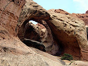
Natural arch
A natural arch or natural bridge is a natural geological formation where a rock arch forms, with an opening underneath. Most natural arches form as a narrow ridge, walled by cliffs, become narrower from erosion, with a softer rock stratum under the cliff-forming stratum gradually eroding out until...
in Arches National Park
Arches National Park
Arches National Park is a U.S. National Park in eastern Utah. It is known for preserving over 2000 natural sandstone arches, including the world-famous Delicate Arch, in addition to a variety of unique geological resources and formations....
and 'goblins' (the local name for hoodoo
Hoodoo (geology)
A hoodoo is a tall, thin spire of rock that protrudes from the bottom of an arid drainage basin or badland. Hoodoos consist of relatively soft rock topped by harder, less easily eroded stone that protects each column from the elements...
s) in nearby Goblin Valley State Park
Goblin Valley State Park
Goblin Valley State Park is a state park of Utah, USA.Its eminent feature is its thousands of hoodoos and hoodoo rocks, which are formations of mushroom-shaped rock pinnacles, some as high as several meters...
. Entrada exposures in the southern part of the park are mostly made of flat-bedded siltstones and erode into slopes. Moving north, Entrada exposures increasingly become rich in cross-bedded sandstone and erode into cliffs with fewer and fewer slopes.
Fine-grained sand and silt mixed with sandy lime were laid down as sediments on top of the Entrada Sandstone, forming the locally 0 to 175 foot (53 m) thick erosion-resistant Curtis Formation. A green iron
Iron
Iron is a chemical element with the symbol Fe and atomic number 26. It is a metal in the first transition series. It is the most common element forming the planet Earth as a whole, forming much of Earth's outer and inner core. It is the fourth most common element in the Earth's crust...
potassium
Potassium
Potassium is the chemical element with the symbol K and atomic number 19. Elemental potassium is a soft silvery-white alkali metal that oxidizes rapidly in air and is very reactive with water, generating sufficient heat to ignite the hydrogen emitted in the reaction.Potassium and sodium are...
silicate
Silicate
A silicate is a compound containing a silicon bearing anion. The great majority of silicates are oxides, but hexafluorosilicate and other anions are also included. This article focuses mainly on the Si-O anions. Silicates comprise the majority of the earth's crust, as well as the other...
called glauconite
Glauconite
Glauconite is an iron potassium phyllosilicate mineral of characteristic green color with very low weathering resistance and very friable.It crystallizes with a monoclinic geometry...
in the Curtis indicates it was deposited in a shallow sea. Outcrops of the light grayish-green Curtis can be seen as a capstone in the northern section of the park while it is locally absent in the southern part.
Tidal flat conditions returned as the shallow sea that created the Curtis Formation retreated from land. Thin beds of reddish-brown mudstone alternating with less frequent beds of greenish-gray sandstone and limestone were deposited as sediments, forming the locally 50 to 250 foot (15 to 75 m) thick Summerville Formation. This formation erodes into ledgy cliffs and slopes and can be seen above Curtis caprock in Cathedral Valley. Fossilized mudcracks and ripple marks are found in the Curtis along with up to 28 foot (8.5 m) thick gypsum
Gypsum
Gypsum is a very soft sulfate mineral composed of calcium sulfate dihydrate, with the chemical formula CaSO4·2H2O. It is found in alabaster, a decorative stone used in Ancient Egypt. It is the second softest mineral on the Mohs Hardness Scale...
-rich beds.
Morrison Formation (Jurassic)
Sea level
Mean sea level is a measure of the average height of the ocean's surface ; used as a standard in reckoning land elevation...
, streams laid down mud and sand in their channels, on lakebeds, and in swamp
Swamp
A swamp is a wetland with some flooding of large areas of land by shallow bodies of water. A swamp generally has a large number of hammocks, or dry-land protrusions, covered by aquatic vegetation, or vegetation that tolerates periodical inundation. The two main types of swamp are "true" or swamp...
y plains during the Upper Jurassic. This became the Morrison Formation
Morrison Formation
The Morrison Formation is a distinctive sequence of Late Jurassic sedimentary rock that is found in the western United States, which has been the most fertile source of dinosaur fossils in North America. It is composed of mudstone, sandstone, siltstone and limestone and is light grey, greenish...
, which is locally divided into three members (from oldest to youngest);
- Tidwell Member,
- Salt Wash, and
- Brushy Basin.
The 50 to 100 foot (15 to 30 m) thick Tidwell Member is locally difficult to recognize and therefore may or may not be in the area's rocks. Easier to identify and study outcrops elsewhere in southeastern Utah indicate they were deposited in hypersaline lagoon
Lagoon
A lagoon is a body of shallow sea water or brackish water separated from the sea by some form of barrier. The EU's habitat directive defines lagoons as "expanses of shallow coastal salt water, of varying salinity or water volume, wholly or partially separated from the sea by sand banks or shingle,...
s.
Clay, mud, silt, cross-bedded sand and pebbles were later deposited by meandering stream
Stream
A stream is a body of water with a current, confined within a bed and stream banks. Depending on its locale or certain characteristics, a stream may be referred to as a branch, brook, beck, burn, creek, "crick", gill , kill, lick, rill, river, syke, bayou, rivulet, streamage, wash, run or...
s and in flood plains, forming the locally 100 to 500 foot (30 to 150 m) thick Salt Wash Member. Claystone and mudstone beds of this member erode into gray slopes that can exhibit brown, red, yellow, and green colors. Salt Wash sandstone is moderately sorted and fine to medium grained while pebble conglomerate beds are made of chert
Chert
Chert is a fine-grained silica-rich microcrystalline, cryptocrystalline or microfibrous sedimentary rock that may contain small fossils. It varies greatly in color , but most often manifests as gray, brown, grayish brown and light green to rusty red; its color is an expression of trace elements...
with small amounts of silica-rich limestone. Both bed types erode into ledges and small cliffs. The Salt Wash was locally mined in the 1950s to extract uranium
Uranium
Uranium is a silvery-white metallic chemical element in the actinide series of the periodic table, with atomic number 92. It is assigned the chemical symbol U. A uranium atom has 92 protons and 92 electrons, of which 6 are valence electrons...
ore.
The 200 to 350 foot (60 to 105 m) thick Brushy Basin Member is composed of claystone, mudstone, and siltstone with small amounts of conglomerate and sandstone. Clays in this member are rich in smectite and thus tend to swell when wet and dry to a crumbled surface that looks a bit like popcorn
Popcorn
Popcorn, or popping corn, is corn which expands from the kernel and puffs up when heated. Corn is able to pop because, like sorghum, quinoa and millet, its kernels have a hard moisture-sealed hull and a dense starchy interior. This allows pressure to build inside the kernel until an explosive...
. Fossilized dinosaur
Dinosaur
Dinosaurs are a diverse group of animals of the clade and superorder Dinosauria. They were the dominant terrestrial vertebrates for over 160 million years, from the late Triassic period until the end of the Cretaceous , when the Cretaceous–Paleogene extinction event led to the extinction of...
bones are abundant in this member in several places located in Utah and western Colorado
Colorado
Colorado is a U.S. state that encompasses much of the Rocky Mountains as well as the northeastern portion of the Colorado Plateau and the western edge of the Great Plains...
. The bones are usually scattered and are thus hard to identify but nearly complete skeleton
Skeleton
The skeleton is the body part that forms the supporting structure of an organism. There are two different skeletal types: the exoskeleton, which is the stable outer shell of an organism, and the endoskeleton, which forms the support structure inside the body.In a figurative sense, skeleton can...
s have been found in lake floor and flood-plain clays. Good exposures of the Brushy Basin Member can be seen in the Bentonite Hills.
Cedar Mountain and Dakota formations (Cretaceous)
Cedar Mountain Formation
The Cedar Mountain Formation is the name given to distinctive sedimentary rocks in eastern Utah that occur between the underlying Morrison Formation and overlying Naturita Formation . It is composed of non-marine sediments, that is, sediments deposited in rivers, lakes and on flood plains...
. The 73 foot (22 m) thick Buckhorn Conglomerate Member thins out north and east of the park and is nearly absent in it, making it difficult to distinguish the underlying Morrison from the somewhat more pastel-colored Cedar Mountain. Fossilized freshwater animals such as mollusks and ostracod
Ostracod
Ostracoda is a class of the Crustacea, sometimes known as the seed shrimp because of their appearance. Some 65,000 species have been identified, grouped into several orders....
s along with dinosaurs, fish scale
Fish scale
Fish scale may refer to:* The rigid plates on the skin of a fish* Fishscale, an album by Ghostface Killah* Fishscale cocaine* Fish Scales, a rapper...
s, pollen
Pollen
Pollen is a fine to coarse powder containing the microgametophytes of seed plants, which produce the male gametes . Pollen grains have a hard coat that protects the sperm cells during the process of their movement from the stamens to the pistil of flowering plants or from the male cone to the...
and a genus of fern called Tempskya have been found in this formation.
The passive continental margin became active when the Farallon Plate
Farallon Plate
The Farallon Plate was an ancient oceanic plate, which began subducting under the west coast of the North American Plate— then located in modern Utah— as Pangaea broke apart during the Jurassic Period...
started to dive below the North American Plate
North American Plate
The North American Plate is a tectonic plate covering most of North America, Greenland, Cuba, Bahamas, and parts of Siberia, Japan and Iceland. It extends eastward to the Mid-Atlantic Ridge and westward to the Chersky Range in eastern Siberia. The plate includes both continental and oceanic crust...
. Geologists call the resulting mountain-building event the Sevier orogeny
Sevier orogeny
The Sevier orogeny was a mountain-building event that affected western North America from Canada to the north to Mexico to the south. This orogeny was the result of convergent boundary tectonic activity between approximately 140 million years ago and 50 Ma. The Sevier River area of central Utah...
. Compressive forces detached sedimentary units across western Utah and Nevada
Nevada
Nevada is a state in the western, mountain west, and southwestern regions of the United States. With an area of and a population of about 2.7 million, it is the 7th-largest and 35th-most populous state. Over two-thirds of Nevada's people live in the Las Vegas metropolitan area, which contains its...
from their Precambrian basement rocks and pushed them eastward. The weight of the resulting high mountain range
Mountain range
A mountain range is a single, large mass consisting of a succession of mountains or narrowly spaced mountain ridges, with or without peaks, closely related in position, direction, formation, and age; a component part of a mountain system or of a mountain chain...
that formed to the west, lowered much of Utah and allowed the sea to invade. This grew into a vast sea that periodically divided North America in the Cretaceous
Cretaceous
The Cretaceous , derived from the Latin "creta" , usually abbreviated K for its German translation Kreide , is a geologic period and system from circa to million years ago. In the geologic timescale, the Cretaceous follows the Jurassic period and is followed by the Paleogene period of the...
called the Western Interior Seaway
Western Interior Seaway
The Western Interior Seaway, also called the Cretaceous Seaway, the Niobraran Sea, and the North American Inland Sea, was a huge inland sea that split the continent of North America into two halves, Laramidia and Appalachia, during most of the mid- and late-Cretaceous Period...
.
Non-marine sediments of the approximately 100 to 94 million year old Dakota Sandstone
Dakota Sandstone
The Dakota Sandstone is a general term for an ill-defined early Cretaceous formation of the Rocky Mountains and Great Plains. It consists of sandy, shallow-marine deposits with intermittent mud flat sediments, and occasional stream deposits...
were deposited on the shore of this seaway early in the Cretaceous. The 0 to 150 foot (0 to 45 m) thick formation consists of fine-grained tan to brownish-gray colored quartz
Quartz
Quartz is the second-most-abundant mineral in the Earth's continental crust, after feldspar. It is made up of a continuous framework of SiO4 silicon–oxygen tetrahedra, with each oxygen being shared between two tetrahedra, giving an overall formula SiO2. There are many different varieties of quartz,...
-rich sandstone that is interbedded with thin layers of carbon
Carbon
Carbon is the chemical element with symbol C and atomic number 6. As a member of group 14 on the periodic table, it is nonmetallic and tetravalent—making four electrons available to form covalent chemical bonds...
-rich shale, coal
Coal
Coal is a combustible black or brownish-black sedimentary rock usually occurring in rock strata in layers or veins called coal beds or coal seams. The harder forms, such as anthracite coal, can be regarded as metamorphic rock because of later exposure to elevated temperature and pressure...
, and conglomerate.
Petrified wood
Petrified wood
Petrified wood is the name given to a special type of fossilized remains of terrestrial vegetation. It is the result of a tree having turned completely into stone by the process of permineralization...
is found in the lower part of the formation while fossilized marine bivalves such as Corbula
Corbula
Corbula is a genus of bivalve molluscs in the Corbulidae family -Species :* Corbula aequivalvis Philippi, 1836* Corbula albuginosa Hinds, 1843* Corbula amethystina * Corbula arcaeformis Lynge, 1909...
and Pycnodonte newberryi
Pycnodonte newberryi
Pycnodonte newberryi is a species in the Pycnodonte genus of extinct oysters, marine bivalve mollusks in the family Gryphaeidae. It lived from the Cretaceous period, 90 to 130 million years old. P. newberryi fossils generally exist in large layers or beds...
are in the upper layers. This fossil progression shows a record of flooding that created the seaway. Dakota erode into small cliffs and hogbacks that can be seen in the southern section of the park.
Mancos Shale and Mesaverde Formation (Cretaceous)
Approximately 94 to 85 million years ago, the seaway advanced onto and retreated from land as it laid down the Mancos ShaleMancos Shale
The Mancos Shale or Mancos Group is an Upper Cretaceous geologic formation of the Western United States dominated by mudrock that accumulated in offshore and marine environments of the Cretaceous North American Inland Sea. The Mancos was deposited during the Cenomanian through Campanian ages,...
. The Mancos is composed mostly of shale
Shale
Shale is a fine-grained, clastic sedimentary rock composed of mud that is a mix of flakes of clay minerals and tiny fragments of other minerals, especially quartz and calcite. The ratio of clay to other minerals is variable. Shale is characterized by breaks along thin laminae or parallel layering...
but two of its members, the Ferron and Muley Canyon, are sandstone that were laid down when relative sea level temporarily dropped. The five Mancos members from oldest to youngest are:
- Tununk Shale,
- Ferron Sandstone,
- Blue Gate Shale,
- Muley Canyon, and
- Masuk.

Mesa
A mesa or table mountain is an elevated area of land with a flat top and sides that are usually steep cliffs. It takes its name from its characteristic table-top shape....
s and butte
Butte
A butte is a conspicuous isolated hill with steep, often vertical sides and a small, relatively flat top; it is smaller than mesas, plateaus, and table landform tables. In some regions, such as the north central and northwestern United States, the word is used for any hill...
s in the southernmost part of the park and in badlands east of the park.
Open marine conditions created the locally 40 to 720 feet (12 to 220 m) thick gullied slope-forming Tununk Shale Member. It is made of bluish-gray shale
Shale
Shale is a fine-grained, clastic sedimentary rock composed of mud that is a mix of flakes of clay minerals and tiny fragments of other minerals, especially quartz and calcite. The ratio of clay to other minerals is variable. Shale is characterized by breaks along thin laminae or parallel layering...
with interbedded mudstone
Mudstone
Mudstone is a fine grained sedimentary rock whose original constituents were clays or muds. Grain size is up to 0.0625 mm with individual grains too small to be distinguished without a microscope. With increased pressure over time the platey clay minerals may become aligned, with the...
, fine-grained sandstone
Sandstone
Sandstone is a sedimentary rock composed mainly of sand-sized minerals or rock grains.Most sandstone is composed of quartz and/or feldspar because these are the most common minerals in the Earth's crust. Like sand, sandstone may be any colour, but the most common colours are tan, brown, yellow,...
and siltstone
Siltstone
Siltstone is a sedimentary rock which has a grain size in the silt range, finer than sandstone and coarser than claystones.- Description :As its name implies, it is primarily composed of silt sized particles, defined as grains 1/16 - 1/256 mm or 4 to 8 on the Krumbein phi scale...
. The Tununk erodes into a slope and is locally fossil-rich. It is most prominently exposed in the Blue Desert immediately southeast of Cathedral Valley and contains fossil
Fossil
Fossils are the preserved remains or traces of animals , plants, and other organisms from the remote past...
ized examples of cephalopod
Cephalopod
A cephalopod is any member of the molluscan class Cephalopoda . These exclusively marine animals are characterized by bilateral body symmetry, a prominent head, and a set of arms or tentacles modified from the primitive molluscan foot...
s, bivalves, and fish scale
Fish scale
Fish scale may refer to:* The rigid plates on the skin of a fish* Fishscale, an album by Ghostface Killah* Fishscale cocaine* Fish Scales, a rapper...
s.
A wave-dominated delta and river system then spread over the area, creating the locally 205 to 385 feet (62 to 117 m) thick cliff-forming Ferron Sandstone. It is composed of brown fine-grained sandstone along with white cross-bedded sandstone with interbedded carbonate
Carbonate
In chemistry, a carbonate is a salt of carbonic acid, characterized by the presence of the carbonate ion, . The name may also mean an ester of carbonic acid, an organic compound containing the carbonate group C2....
-rich gray shale. The marine bivalve Inoceramus
Inoceramus
Inoceramus is an extinct genus of fossil marine pteriomorphian bivalves that superficially resembled the related winged pearly oysters of the extant genus Pteria....
and trace fossil
Trace fossil
Trace fossils, also called ichnofossils , are geological records of biological activity. Trace fossils may be impressions made on the substrate by an organism: for example, burrows, borings , urolites , footprints and feeding marks, and root cavities...
s of Ophiomorpha
Ophiomorpha
Ophiomorpha is an ichnotaxon, usually interpreted as a burrow of an organism living in the near-shore environment. It is often considered part of the Skolithos ichnofacies....
are found in the lower part of this member. Ferron Sandstone north of the area contains seams of coal
Coal
Coal is a combustible black or brownish-black sedimentary rock usually occurring in rock strata in layers or veins called coal beds or coal seams. The harder forms, such as anthracite coal, can be regarded as metamorphic rock because of later exposure to elevated temperature and pressure...
in its upper part, prompting some petroleum
Petroleum
Petroleum or crude oil is a naturally occurring, flammable liquid consisting of a complex mixture of hydrocarbons of various molecular weights and other liquid organic compounds, that are found in geologic formations beneath the Earth's surface. Petroleum is recovered mostly through oil drilling...
geologists to study this member to model oil-bearing regions.
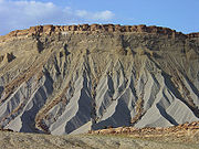
Cretaceous
The Cretaceous , derived from the Latin "creta" , usually abbreviated K for its German translation Kreide , is a geologic period and system from circa to million years ago. In the geologic timescale, the Cretaceous follows the Jurassic period and is followed by the Paleogene period of the...
, forming the locally 1,200 to 1,500 foot (365 to 460 m) thick slope-forming Blue Gate Shale. This member is composed of bentonite
Bentonite
Bentonite is an absorbent aluminium phyllosilicate, essentially impure clay consisting mostly of montmorillonite. There are different types of bentonite, each named after the respective dominant element, such as potassium , sodium , calcium , and aluminum . Experts debate a number of nomenclatorial...
rich clay
Clay
Clay is a general term including many combinations of one or more clay minerals with traces of metal oxides and organic matter. Geologic clay deposits are mostly composed of phyllosilicate minerals containing variable amounts of water trapped in the mineral structure.- Formation :Clay minerals...
s, siltstone and some sandstone. It erodes into gullied slopes similar in appearance to the Tununk Shale. The presence of two species of planktonic foraminifera
Foraminifera
The Foraminifera , or forams for short, are a large group of amoeboid protists which are among the commonest plankton species. They have reticulating pseudopods, fine strands of cytoplasm that branch and merge to form a dynamic net...
in the upper Blue Gate, Clioscaphites vermiformis and Clioscaphites choteauenis, was used to date this member.
An ancient shoreline once again approached the area, resulting in the formation of the locally 300 to 400 feet (90 to 120 m) thick Muley Canyon Member. It is composed of evenly bedded, fine-grained sandstone and carbon
Carbon
Carbon is the chemical element with symbol C and atomic number 6. As a member of group 14 on the periodic table, it is nonmetallic and tetravalent—making four electrons available to form covalent chemical bonds...
-rich shales. Coal beds are found in the upper parts of this member, indicating continental coastal plain conditions at that time.
Alternating layers of shallow marine and non-marine sediments were deposited as the shoreline fluctuated back and forth over the area. These sediments became the locally 650 to 750 foot (200 to 230 m) thick Masuk Member. The Masuk consists of cliff-forming cross-bedded sandstones and slope-forming yellowish-gray to bluish-gray mudstones with interbedded light gray sandstones. Fossils of bivalves, ceratopsian dinosaur
Dinosaur
Dinosaurs are a diverse group of animals of the clade and superorder Dinosauria. They were the dominant terrestrial vertebrates for over 160 million years, from the late Triassic period until the end of the Cretaceous , when the Cretaceous–Paleogene extinction event led to the extinction of...
s, crocodile
Crocodile
A crocodile is any species belonging to the family Crocodylidae . The term can also be used more loosely to include all extant members of the order Crocodilia: i.e...
s, gastropods, and turtle
Turtle
Turtles are reptiles of the order Testudines , characterised by a special bony or cartilaginous shell developed from their ribs that acts as a shield...
s have been collected in this member.
The Western Interior Seaway was shrinking due to infilling and uplift while the high mountains to the east were being reduced by erosion. Barrier beach
Beach
A beach is a geological landform along the shoreline of an ocean, sea, lake or river. It usually consists of loose particles which are often composed of rock, such as sand, gravel, shingle, pebbles or cobblestones...
es and river delta
River delta
A delta is a landform that is formed at the mouth of a river where that river flows into an ocean, sea, estuary, lake, reservoir, flat arid area, or another river. Deltas are formed from the deposition of the sediment carried by the river as the flow leaves the mouth of the river...
s migrated eastward into the seaway. The resulting 300 to 400 foot (90 to 120 m) thick Mesaverde Formation
Mesaverde Formation
The Mesaverde Formation is a Late Cretaceous geologic formation.The formation is described by W.G. Pierce as interbedded light gray sandstone and gray shale in upper part; lower part massive, light-buff, ledge-forming sandstone containing thin lenticular coal beds.The formation occurs in various...
consists of light-brown to dark-gray thick-bedded and cross-stratified sandstone with interbedded dark gray shale and intertongues with the Masuk Member of the overlying Mancos Shale. Only small remnants are found capping a few mesas in the park's eastern section.
Waterpocket Fold, Lake Uinta and volcanism
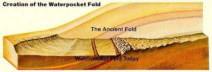
Laramide orogeny
The Laramide orogeny was a period of mountain building in western North America, which started in the Late Cretaceous, 70 to 80 million years ago, and ended 35 to 55 million years ago. The exact duration and ages of beginning and end of the orogeny are in dispute, as is the cause. The Laramide...
compacted the region from about 70 million to 50 million years ago and in the process created the Rocky Mountains
Rocky Mountains
The Rocky Mountains are a major mountain range in western North America. The Rocky Mountains stretch more than from the northernmost part of British Columbia, in western Canada, to New Mexico, in the southwestern United States...
. Many monoclines (a type of gentle upward fold
Fold (geology)
The term fold is used in geology when one or a stack of originally flat and planar surfaces, such as sedimentary strata, are bent or curved as a result of permanent deformation. Synsedimentary folds are those due to slumping of sedimentary material before it is lithified. Folds in rocks vary in...
in rock strata) were also formed by the deep compressive forces of the Laramide. One of those monocline
Monocline
A monocline is a step-like fold in rock strata consisting of a zone of steeper dip within an otherwise horizontal or gently-dipping sequence.-Formation:Monoclines may be formed in several different ways...
s, called the Waterpocket Fold
Waterpocket Fold
The Waterpocket Fold is a geologic landform that defines Capitol Reef National Park in the western United States. This monoclinal fold extends for slightly over 100 miles in the desert of central Utah. It can be seen via three scenic routes in the park. One route leads to a famous landmark known as...
, is the major geographic feature of the park. The 100 mile (160 km) long fold has a north-south alignment with a steeply east-dipping side. The rock layers on the west side of the Waterpocket Fold have been lifted more than 7,000 feet (2,100 m) higher than the layers on the east. Thus older rocks are exposed on the western part of the fold and younger rocks on the eastern part. It is possible that this particular fold may have been created where it is due to movement along a fault thought to be in the Precambrian
Precambrian
The Precambrian is the name which describes the large span of time in Earth's history before the current Phanerozoic Eon, and is a Supereon divided into several eons of the geologic time scale...
basement rocks hidden well below any exposed formations (some small earthquake
Earthquake
An earthquake is the result of a sudden release of energy in the Earth's crust that creates seismic waves. The seismicity, seismism or seismic activity of an area refers to the frequency, type and size of earthquakes experienced over a period of time...
s centered below the fold in 1979 may be from such a fault).
Contemporary with the Waterpocket Fold's formation was the development of an intermontane (between mountains) basin in the area. Lake Uinta filled this basin with stream water derived from the north and south. This large lake
Lake
A lake is a body of relatively still fresh or salt water of considerable size, localized in a basin, that is surrounded by land. Lakes are inland and not part of the ocean and therefore are distinct from lagoons, and are larger and deeper than ponds. Lakes can be contrasted with rivers or streams,...
existed from about 58 million until 35 million years ago and is responsible for creating the Flagstaff Limestone and Green River Formation
Green River Formation
The Green River Formation is an Eocene geologic formation that records the sedimentation in a group of intermountain lakes. The sediments are deposited in very fine layers, a dark layer during the growing season and a light-hue inorganic layer in winter. Each pair of layers is called a varve and...
, which locally reach a thickness of around 200 feet (60 m). Elsewhere these formations have a combined thickness of over 9,000 feet (2,740 m). The Flagstaff is a white-colored, fossil rich layer that is composed of limestone, tuffa and conglomerate that erodes into ledges and slopes.
Compressive forces caused by the Laramide orogeny
Orogeny
Orogeny refers to forces and events leading to a severe structural deformation of the Earth's crust due to the engagement of tectonic plates. Response to such engagement results in the formation of long tracts of highly deformed rock called orogens or orogenic belts...
were followed by some minor stretching as the crust tried to find a new equilibrium. This created weaknesses in the crust that magma
Magma
Magma is a mixture of molten rock, volatiles and solids that is found beneath the surface of the Earth, and is expected to exist on other terrestrial planets. Besides molten rock, magma may also contain suspended crystals and dissolved gas and sometimes also gas bubbles. Magma often collects in...
took advantage of by squeezing toward the surface to create composite volcanos west of the area some 25 to 20 million years ago. Within the fold, magma intruded through and between formations about 4.6 to 3.7 million years ago to respectively create dike
Dike (geology)
A dike or dyke in geology is a type of sheet intrusion referring to any geologic body that cuts discordantly across* planar wall rock structures, such as bedding or foliation...
s and sill
Sill (geology)
In geology, a sill is a tabular sheet intrusion that has intruded between older layers of sedimentary rock, beds of volcanic lava or tuff, or even along the direction of foliation in metamorphic rock. The term sill is synonymous with concordant intrusive sheet...
s. Small basalt
Basalt
Basalt is a common extrusive volcanic rock. It is usually grey to black and fine-grained due to rapid cooling of lava at the surface of a planet. It may be porphyritic containing larger crystals in a fine matrix, or vesicular, or frothy scoria. Unweathered basalt is black or grey...
ic lava flows erupted through fissures at the surface and igneous activity continued sporadically afterwards. Subsequent erosion preferentially removed the softer sedimentary rock that initially entombed the dikes, sills, and volcanic plugs, often leaving them standing in relief. Good examples can be seen in South Desert and Cathedral Valley at the northern end of the fold.
Erosion
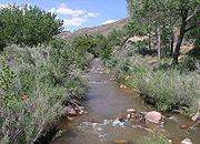
Colorado Plateau
The Colorado Plateau, also called the Colorado Plateau Province, is a physiographic region of the Intermontane Plateaus, roughly centered on the Four Corners region of the southwestern United States. The province covers an area of 337,000 km2 within western Colorado, northwestern New Mexico,...
s. This time the uplift was more even, leaving the overall orientation of the formations mostly intact. Most of the erosion that carved today's landscape occurred after the uplift of the Colorado Plateau with much of the major canyon cutting probably occurring between 1 and 6 million years ago. Even in this desert climate, water is the erosional agent most responsible for the carving of the landscape. The pull of gravity, in the form of rock falls or rock creep, plays a major role in the shaping of the cliff lines. Wind
Wind
Wind is the flow of gases on a large scale. On Earth, wind consists of the bulk movement of air. In outer space, solar wind is the movement of gases or charged particles from the sun through space, while planetary wind is the outgassing of light chemical elements from a planet's atmosphere into space...
is a minor agent of erosion here.
The drainage system in the area was rearranged and steepened as the Waterpocket Fold was uplifted. Larger streams, such as the Fremont River
Fremont River (Utah)
The Fremont River in Utah flows from the Johnson Valley Reservoir, which is located on the Wasatch Plateau near Fish Lake, southwest through Capitol Reef National Park to the Muddy Creek near Hanksville where the two rivers combine to form the Dirty Devil River, a tributary of the Colorado River...
, were more likely to keep up with the uplift by downcutting
Downcutting
Downcutting, also called erosional downcutting or downward erosion or vertical erosion is a geological process that deepens the channel of a stream or valley by removing material from the stream's bed or the valley's floor. How fast downcutting occurs depends on the stream's base level, which is...
into the Waterpocket Fold faster. Other streams, such as Sand Creek, changed their course by flowing parallel to the fold and cutting into less resistant formations. Yet other streams tried to keep up with the uplift by carving slot canyon
Canyon
A canyon or gorge is a deep ravine between cliffs often carved from the landscape by a river. Rivers have a natural tendency to reach a baseline elevation, which is the same elevation as the body of water it will eventually drain into. This forms a canyon. Most canyons were formed by a process of...
s only to later change course, leaving their canyons literally high and dry. A total of 7,000 feet (2,100 m) of overlying Mesozoic
Mesozoic
The Mesozoic era is an interval of geological time from about 250 million years ago to about 65 million years ago. It is often referred to as the age of reptiles because reptiles, namely dinosaurs, were the dominant terrestrial and marine vertebrates of the time...
and Tertiary
Tertiary
The Tertiary is a deprecated term for a geologic period 65 million to 2.6 million years ago. The Tertiary covered the time span between the superseded Secondary period and the Quaternary...
sediment has been removed by erosion in the area.

Pleistocene
The Pleistocene is the epoch from 2,588,000 to 11,700 years BP that spans the world's recent period of repeated glaciations. The name pleistocene is derived from the Greek and ....
epoch and briefly returned via at least two neoglacial episodes (little ice age
Little Ice Age
The Little Ice Age was a period of cooling that occurred after the Medieval Warm Period . While not a true ice age, the term was introduced into the scientific literature by François E. Matthes in 1939...
s) in the current epoch, the Holocene
Holocene
The Holocene is a geological epoch which began at the end of the Pleistocene and continues to the present. The Holocene is part of the Quaternary period. Its name comes from the Greek words and , meaning "entirely recent"...
. The various rivers and streams in the area were engorged by increased precipitation and with melt-water from mountain glacier
Glacier
A glacier is a large persistent body of ice that forms where the accumulation of snow exceeds its ablation over many years, often centuries. At least 0.1 km² in area and 50 m thick, but often much larger, a glacier slowly deforms and flows due to stresses induced by its weight...
s on the Henry Mountains
Henry Mountains
The Henry Mountains are located in the southeastern portion of the U.S. state of Utah and run in a generally north-south direction, extending over a distance of about 30 miles . They were named by John Wesley Powell in honour of Joseph Henry, the first secretary of the Smithsonian Institution. The...
to the east and the Aquarius Plateau
Aquarius Plateau
The Aquarius Plateau is a physiographic region within Garfield and Wayne counties in south-central Utah. The plateau, an uplift on the much larger Colorado Plateau, is the highest in North America...
to the west of the park. Flash flood
Flash flood
A flash flood is a rapid flooding of geomorphic low-lying areas—washes, rivers, dry lakes and basins. It may be caused by heavy rain associated with a storm, hurricane, or tropical storm or meltwater from ice or snow flowing over ice sheets or snowfields...
s, mass wasting
Mass wasting
Mass wasting, also known as slope movement or mass movement, is the geomorphic process by which soil, regolith, and rock move downslope under the force of gravity. Types of mass wasting include creep, slides, flows, topples, and falls, each with its own characteristic features, and taking place...
of hillsides, frost wedging, and landslide
Landslide
A landslide or landslip is a geological phenomenon which includes a wide range of ground movement, such as rockfalls, deep failure of slopes and shallow debris flows, which can occur in offshore, coastal and onshore environments...
s all contributed to a significantly faster rate of erosion
Erosion
Erosion is when materials are removed from the surface and changed into something else. It only works by hydraulic actions and transport of solids in the natural environment, and leads to the deposition of these materials elsewhere...
. Glaciers plucked 20 to 30 million year old black basaltic boulders from atop Boulder
Boulder Mountain (Utah)
Boulder Mountain in Utah, USA makes up half of the Aquarius Plateau of South Central Utah in Wayne and Garfield counties. The mountain rises to the west of Capitol Reef National Park and consists of steep slopes and cliffs with over 50,000 acres of rolling forest and meadowlands on the top...
and Thousand Lake Mountain
Thousand Lake Mountain
Thousand Lake Mountain is in South-Central Utah, United States, just North and West of Capitol Reef National Park and North of Boulder Mountain. Thousand Lake Mountain is surrounded by several small towns . The areas on and around Thousand Lake Mountain are used for farming, camping, hiking,...
s that were subsequently deposited over the park area by meltwater streams from the glaciers, rockslides and flood
Flood
A flood is an overflow of an expanse of water that submerges land. The EU Floods directive defines a flood as a temporary covering by water of land not normally covered by water...
s.