

Geology of the Canyonlands area
Encyclopedia
Canyonlands National Park
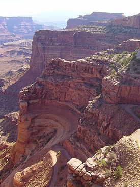
Canyonlands National Park is a U.S. National Park located in southeastern Utah near the town of Moab and preserves a colorful landscape eroded into countless canyons, mesas and buttes by the Colorado River, the Green River, and their respective tributaries. The park is divided into four districts:...
that range in age from Pennsylvanian
Pennsylvanian
The Pennsylvanian is, in the ICS geologic timescale, the younger of two subperiods of the Carboniferous Period. It lasted from roughly . As with most other geochronologic units, the rock beds that define the Pennsylvanian are well identified, but the exact date of the start and end are uncertain...
to Cretaceous
Cretaceous
The Cretaceous , derived from the Latin "creta" , usually abbreviated K for its German translation Kreide , is a geologic period and system from circa to million years ago. In the geologic timescale, the Cretaceous follows the Jurassic period and is followed by the Paleogene period of the...
. The oldest and perhaps most interesting was created from evaporite
Evaporite
Evaporite is a name for a water-soluble mineral sediment that result from concentration and crystallization by evaporation from an aqueous solution. There are two types of evaporate deposits, marine which can also be described as ocean deposits, and non-marine which are found in standing bodies of...
s deposited from evaporating seawater. Various fossil
Fossil
Fossils are the preserved remains or traces of animals , plants, and other organisms from the remote past...
-rich limestone
Limestone
Limestone is a sedimentary rock composed largely of the minerals calcite and aragonite, which are different crystal forms of calcium carbonate . Many limestones are composed from skeletal fragments of marine organisms such as coral or foraminifera....
s, sandstone
Sandstone
Sandstone is a sedimentary rock composed mainly of sand-sized minerals or rock grains.Most sandstone is composed of quartz and/or feldspar because these are the most common minerals in the Earth's crust. Like sand, sandstone may be any colour, but the most common colours are tan, brown, yellow,...
s, and shale
Shale
Shale is a fine-grained, clastic sedimentary rock composed of mud that is a mix of flakes of clay minerals and tiny fragments of other minerals, especially quartz and calcite. The ratio of clay to other minerals is variable. Shale is characterized by breaks along thin laminae or parallel layering...
s were deposited by advancing and retreating warm shallow seas through much of the remaining Paleozoic
Paleozoic
The Paleozoic era is the earliest of three geologic eras of the Phanerozoic eon, spanning from roughly...
.
Eroded sediment from a nearby mountain range
Mountain range
A mountain range is a single, large mass consisting of a succession of mountains or narrowly spaced mountain ridges, with or without peaks, closely related in position, direction, formation, and age; a component part of a mountain system or of a mountain chain...
later mixed with coastal dune and sand bar deposits. The end of the Paleozoic and the start of the Mesozoic
Mesozoic
The Mesozoic era is an interval of geological time from about 250 million years ago to about 65 million years ago. It is often referred to as the age of reptiles because reptiles, namely dinosaurs, were the dominant terrestrial and marine vertebrates of the time...
saw the last seas start to leave the region for good. A subdued topography was dominated by flood plains and tidal flats. Now much further inland, the Triassic
Triassic
The Triassic is a geologic period and system that extends from about 250 to 200 Mya . As the first period of the Mesozoic Era, the Triassic follows the Permian and is followed by the Jurassic. Both the start and end of the Triassic are marked by major extinction events...
climate in the region was dry. Vast desert
Desert
A desert is a landscape or region that receives an extremely low amount of precipitation, less than enough to support growth of most plants. Most deserts have an average annual precipitation of less than...
s covered much of that part of North America
North America
North America is a continent wholly within the Northern Hemisphere and almost wholly within the Western Hemisphere. It is also considered a northern subcontinent of the Americas...
, except for one period when streams for a time fought the sand dunes. Wetter times returned.
The uplift of the Rocky Mountains
Rocky Mountains
The Rocky Mountains are a major mountain range in western North America. The Rocky Mountains stretch more than from the northernmost part of British Columbia, in western Canada, to New Mexico, in the southwestern United States...
starting in late Cretaceous greatly affected the Canyonlands region. Erosion rates increased and further quickened upon the onset of the ice age
Ice age
An ice age or, more precisely, glacial age, is a generic geological period of long-term reduction in the temperature of the Earth's surface and atmosphere, resulting in the presence or expansion of continental ice sheets, polar ice sheets and alpine glaciers...
s in the Pleistocene
Pleistocene
The Pleistocene is the epoch from 2,588,000 to 11,700 years BP that spans the world's recent period of repeated glaciations. The name pleistocene is derived from the Greek and ....
. Modern erosion occurs at a slower rate.
Deposition of sediments
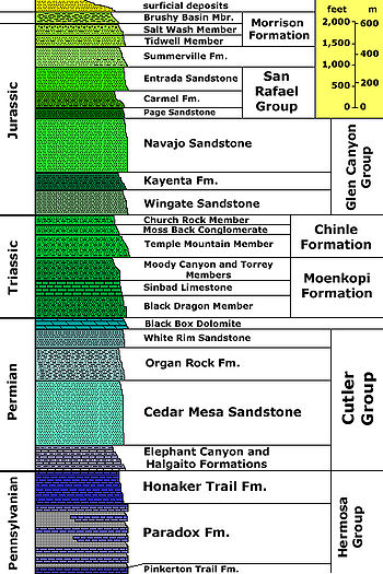
Hermosa Group
A vast sea covered the region in early PennsylvanianPennsylvanian
The Pennsylvanian is, in the ICS geologic timescale, the younger of two subperiods of the Carboniferous Period. It lasted from roughly . As with most other geochronologic units, the rock beds that define the Pennsylvanian are well identified, but the exact date of the start and end are uncertain...
time. A basin
Depression (geology)
A depression in geology is a landform sunken or depressed below the surrounding area. Depressions may be formed by various mechanisms.Structural or tectonic related:...
in the area called Paradox Basin
Paradox Basin
The Paradox Basin is an asymmetric foreland basin located mostly in southeast Utah and southwest Colorado, but extending into northeast Arizona and northwest New Mexico. The basin is a large elongate northwest to southeast oriented depression formed during the late Paleozoic Era...
subsided and a mountain range
Mountain range
A mountain range is a single, large mass consisting of a succession of mountains or narrowly spaced mountain ridges, with or without peaks, closely related in position, direction, formation, and age; a component part of a mountain system or of a mountain chain...
called the Uncompahgre Mountains was uplifted to the east. Great quantities of seawater
Seawater
Seawater is water from a sea or ocean. On average, seawater in the world's oceans has a salinity of about 3.5% . This means that every kilogram of seawater has approximately of dissolved salts . The average density of seawater at the ocean surface is 1.025 g/ml...
were trapped in the subsiding basin and water became increasingly saline
Salinity
Salinity is the saltiness or dissolved salt content of a body of water. It is a general term used to describe the levels of different salts such as sodium chloride, magnesium and calcium sulfates, and bicarbonates...
in the hot and dry climate
Climate
Climate encompasses the statistics of temperature, humidity, atmospheric pressure, wind, rainfall, atmospheric particle count and other meteorological elemental measurements in a given region over long periods...
. Thousands of feet of evaporite
Evaporite
Evaporite is a name for a water-soluble mineral sediment that result from concentration and crystallization by evaporation from an aqueous solution. There are two types of evaporate deposits, marine which can also be described as ocean deposits, and non-marine which are found in standing bodies of...
s (anhydrite
Anhydrite
Anhydrite is a mineral – anhydrous calcium sulfate, CaSO4. It is in the orthorhombic crystal system, with three directions of perfect cleavage parallel to the three planes of symmetry. It is not isomorphous with the orthorhombic barium and strontium sulfates, as might be expected from the...
and gypsum
Gypsum
Gypsum is a very soft sulfate mineral composed of calcium sulfate dihydrate, with the chemical formula CaSO4·2H2O. It is found in alabaster, a decorative stone used in Ancient Egypt. It is the second softest mineral on the Mohs Hardness Scale...
then halite
Halite
Halite , commonly known as rock salt, is the mineral form of sodium chloride . Halite forms isometric crystals. The mineral is typically colorless or white, but may also be light blue, dark blue, purple, pink, red, orange, yellow or gray depending on the amount and type of impurities...
) started to build up in the Mid Pennsylvanian and storm
Storm
A storm is any disturbed state of an astronomical body's atmosphere, especially affecting its surface, and strongly implying severe weather...
s occasionally washed sediment from the nearby mountain
Mountain
Image:Himalaya_annotated.jpg|thumb|right|The Himalayan mountain range with Mount Everestrect 58 14 160 49 Chomo Lonzorect 200 28 335 52 Makalurect 378 24 566 45 Mount Everestrect 188 581 920 656 Tibetan Plateaurect 250 406 340 427 Rong River...
s. Fresh seawater periodically refilled the basin but was never able to flush out the very salty water there (the new water in fact floated on top of the brine
Brine
Brine is water, saturated or nearly saturated with salt .Brine is used to preserve vegetables, fruit, fish, and meat, in a process known as brining . Brine is also commonly used to age Halloumi and Feta cheeses, or for pickling foodstuffs, as a means of preserving them...
). These beds were later lithified to become the Paradox Formation
Paradox formation
The Paradox formation consists of gypsum, anhydrite, and salt, interbedded with shale, sandstone, and limestone. It is the oldest rock exposed in several anticlines in eastern Utah and western Colorado...
, which in turn is part of the Hermosa Group. Compressed salt beds from the Paradox started to flow plastically later in the Pennsylvanian and probably continued to move from then until the end of the Jurassic
Jurassic
The Jurassic is a geologic period and system that extends from about Mya to Mya, that is, from the end of the Triassic to the beginning of the Cretaceous. The Jurassic constitutes the middle period of the Mesozoic era, also known as the age of reptiles. The start of the period is marked by...
. Satellite-based measurements indicate that flow of salt and gypsum continues today to cause flexing and faulting of overlying sedimentary layers.
The Paradox is up to 5000 feet (1520 m) thick in places and in the park is exposed at the bottom of Cataract Canyon
Cataract Canyon
Cataract Canyon is a long canyon of the Colorado River located within Canyonlands National Park and Glen Canyon National Recreation Area in Utah. It begins on the upstream end at the confluence with the Green River and ends at the confluence of the Dirty Devil River...
as rock gypsum
Gypsum
Gypsum is a very soft sulfate mineral composed of calcium sulfate dihydrate, with the chemical formula CaSO4·2H2O. It is found in alabaster, a decorative stone used in Ancient Egypt. It is the second softest mineral on the Mohs Hardness Scale...
inter-bedded with black shale
Shale
Shale is a fine-grained, clastic sedimentary rock composed of mud that is a mix of flakes of clay minerals and tiny fragments of other minerals, especially quartz and calcite. The ratio of clay to other minerals is variable. Shale is characterized by breaks along thin laminae or parallel layering...
. Upward movement of the Paradox is also a possible theory for the creation of Upheaval Dome
Upheaval Dome
Upheaval Dome is an impact structure, the deeply eroded remnants of an impact crater, in Canyonlands National Park near the town Moab, Utah, in the United States....
, although none of the Paradox is exposed on the dome, the predominant theory being a meteor crater.
A warm shallow sea again flooded the region near the end of the Pennsylvanian. Limey oozes, sand, and mud were deposited on top of the salt-filled basin. These sediments became the fossil
Fossil
Fossils are the preserved remains or traces of animals , plants, and other organisms from the remote past...
-rich limestone
Limestone
Limestone is a sedimentary rock composed largely of the minerals calcite and aragonite, which are different crystal forms of calcium carbonate . Many limestones are composed from skeletal fragments of marine organisms such as coral or foraminifera....
s, sandstone
Sandstone
Sandstone is a sedimentary rock composed mainly of sand-sized minerals or rock grains.Most sandstone is composed of quartz and/or feldspar because these are the most common minerals in the Earth's crust. Like sand, sandstone may be any colour, but the most common colours are tan, brown, yellow,...
s, and shale
Shale
Shale is a fine-grained, clastic sedimentary rock composed of mud that is a mix of flakes of clay minerals and tiny fragments of other minerals, especially quartz and calcite. The ratio of clay to other minerals is variable. Shale is characterized by breaks along thin laminae or parallel layering...
s of the gray-colored Honaker Trail Formation. Outcrops of the Honaker Trail can be seen near the bottom of deep canyons in the park, most notably along the Colorado River.
A period of erosion
Erosion
Erosion is when materials are removed from the surface and changed into something else. It only works by hydraulic actions and transport of solids in the natural environment, and leads to the deposition of these materials elsewhere...
then ensued, creating a break in the geologic record called an unconformity
Unconformity
An unconformity is a buried erosion surface separating two rock masses or strata of different ages, indicating that sediment deposition was not continuous. In general, the older layer was exposed to erosion for an interval of time before deposition of the younger, but the term is used to describe...
.
Cutler Formation
Early in the PermianPermian
The PermianThe term "Permian" was introduced into geology in 1841 by Sir Sir R. I. Murchison, president of the Geological Society of London, who identified typical strata in extensive Russian explorations undertaken with Edouard de Verneuil; Murchison asserted in 1841 that he named his "Permian...
a transgressing (advancing) sea laid down the Halgaito Shale. Coastal lowlands returned to the area after the sea regressed (retreated), forming the Elephant Canyon Formation. These formations can now be seen in Cataract and Elephant canyons.
The Uncompahgre Mountains were undergoing extensive erosion during this time. Large alluvial fan
Alluvial fan
An alluvial fan is a fan-shaped deposit formed where a fast flowing stream flattens, slows, and spreads typically at the exit of a canyon onto a flatter plain. A convergence of neighboring alluvial fans into a single apron of deposits against a slope is called a bajada, or compound alluvial...
s filled the basin where it met the range. The resulting Cutler red beds are made of iron
Iron
Iron is a chemical element with the symbol Fe and atomic number 26. It is a metal in the first transition series. It is the most common element forming the planet Earth as a whole, forming much of Earth's outer and inner core. It is the fourth most common element in the Earth's crust...
-rich arkose sandstone. Underwater sand bars and sand dunes on the coast inter-fingered with the red beds and later became the white-colored cliff-forming Cedar Mesa Sandstone
Cedar Mesa Sandstone
Cedar Mesa Sandstone is a sandstone member of the Cutler Formation, found in southeast Utah, southwest Colorado, northwest New Mexico, and northeast Arizona. It is the remains of coastal sand dunes deposited about 245–286 million years ago, during the early Permian period...
. Today these two competing rock units are exposed in a 4 to 5 mile (6.4 to 8 km) wide belt across the park, stretching from south of the Needles through the Maze and to the Elaterite Basin.
Brightly-colored oxidized muds were deposited on top the Cedar Mesa and ranged in color from red to brown. These sediments eventually became the slope-forming Organ Rock Shale formation and can be seen in the Land of Standing Rocks part of the park.
Coastal sand dunes and marine sand bars once again became dominate, creating the cross-bedded cliff-forming White Rim Sandstone. It is exposed as a topographic bench 1200 feet (365 m) below the top of Island in the Sky (thus earning its name) and along the White Rim Trail. A fossilized offshore sand bar made of the White Cliff Sandstone is also exposed in the Elaterite Basin. A tarry dark-brown oil called elaterite
Elaterite
Elaterite, also known as , elastic bitumen or mineral caoutchouc.Elaterite is a brown hydrocarbon varying somewhat in consistency, being sometimes soft, elastic and sticky, like India rubber, and occasionally hard and brittle. It is usually dark brown in color and slightly translucent...
seeps out of the structure, giving the basin its name.
The Permian sea retreated, which exposed the land to a long period of erosion and thus created a second unconformity.
Moenkopi and Chinle formations
Clastic red beds were laid down in shallow-water on top of the eroded PaleozoicPaleozoic
The Paleozoic era is the earliest of three geologic eras of the Phanerozoic eon, spanning from roughly...
surface early in the Triassic
Triassic
The Triassic is a geologic period and system that extends from about 250 to 200 Mya . As the first period of the Mesozoic Era, the Triassic follows the Permian and is followed by the Jurassic. Both the start and end of the Triassic are marked by major extinction events...
. These sediments were deposited on flood plains by stream
Stream
A stream is a body of water with a current, confined within a bed and stream banks. Depending on its locale or certain characteristics, a stream may be referred to as a branch, brook, beck, burn, creek, "crick", gill , kill, lick, rill, river, syke, bayou, rivulet, streamage, wash, run or...
s on an expansive lowland that was slightly slopped in the direction of an ocean
Ocean
An ocean is a major body of saline water, and a principal component of the hydrosphere. Approximately 71% of the Earth's surface is covered by ocean, a continuous body of water that is customarily divided into several principal oceans and smaller seas.More than half of this area is over 3,000...
to the west. Mud built up in tidal flats to become the mudstone
Mudstone
Mudstone is a fine grained sedimentary rock whose original constituents were clays or muds. Grain size is up to 0.0625 mm with individual grains too small to be distinguished without a microscope. With increased pressure over time the platey clay minerals may become aligned, with the...
of Moenkopi Formation
Moenkopi Formation
The Moenkopi is a geological formation that is spread across the U.S. states of New Mexico, northern Arizona, Nevada, southeastern California, eastern Utah and western Colorado. This unit is considered to be a group in Arizona. Part of the Colorado Plateau and Basin and Range, this formation was...
. Examples of this formation, some that still show fossilized ripple marks and mudcracks, can be seen in the northern and western parts of the park.
Another period of erosion returned, creating a third unconformity. The brightly-colored shales of the slope-forming Chinle Formation
Chinle Formation
The Chinle is a geologic formation that is spread across the U.S. states of northern Arizona, Nevada, Utah, western New Mexico, and western Colorado. The Chinle is controversially considered to be synonymous to the Dockum Group in eastern Colorado, eastern New Mexico, southwestern Kansas, the...
were laid down on top of this eroded surface. Petrified wood
Petrified wood
Petrified wood is the name given to a special type of fossilized remains of terrestrial vegetation. It is the result of a tree having turned completely into stone by the process of permineralization...
from the Petrified Forrest Member of the Chinle is sometimes found at the base of Chinle slopes.
Glen Canyon Group
The Glen Canyon GroupGlen Canyon Group
The Glen Canyon Group is a geologic group of formations that is spread across the U.S. states of Nevada, Utah, northern Arizona, north west New Mexico and western Colorado. It is sometimes called the Glen Canyon Sandstone in Colorado and Utah. There are four formations within the group...
of formations includes (from oldest - lowest - to youngest) the
- Wingate SandstoneWingate SandstoneWingate Sandstone is a geologic formation in the Glen Canyon Group that is spread across the Colorado Plateau province of the United States, including northern Arizona, northwest Colorado, Nevada, and Utah. This rock formation is particularly prominent in southeastern Utah, where it forms...
, - Kayenta FormationKayenta FormationThe Kayenta Formation is a geologic layer in the Glen Canyon Group that is spread across the Colorado Plateau province of the United States, including northern Arizona, northwest Colorado, Nevada, and Utah. This rock formation is particularly prominent in southeastern Utah, where it is seen in the...
, and the - Navajo SandstoneNavajo SandstoneNavajo Sandstone is a geologic formation in the Glen Canyon Group that is spread across the U.S. states of northern Arizona, northwest Colorado, and Utah; as part of the Colorado Plateau province of the United States...
These formations are most prominently exposed in the western and northern sections of the park.
Triassic climates progressively became dryer, prompting the formation of sand dunes that buried dry stream beds and their flood plain. This sand became the cliff-forming several hundred feet (many tens of meters) high and red-colored Windgate Sandstone. Outcrops tend to run for hundreds of miles (hundreds of kilometers) with few breaks, creating an impediment to human travel.
For a time climatic conditions became wetter and streams cut channels through the sand dunes. Reddish-brown to lavender-colored sandstones interbedded with siltstone
Siltstone
Siltstone is a sedimentary rock which has a grain size in the silt range, finer than sandstone and coarser than claystones.- Description :As its name implies, it is primarily composed of silt sized particles, defined as grains 1/16 - 1/256 mm or 4 to 8 on the Krumbein phi scale...
s and shales constitute the resulting ledgy slope-forming Kayenta Formation.
The youngest and therefore topmost formation in the Glen Canyon Group was formed after arid conditions returned to the region. A vast and very dry desert
Desert
A desert is a landscape or region that receives an extremely low amount of precipitation, less than enough to support growth of most plants. Most deserts have an average annual precipitation of less than...
, not unlike the modern Sahara
Sahara
The Sahara is the world's second largest desert, after Antarctica. At over , it covers most of Northern Africa, making it almost as large as Europe or the United States. The Sahara stretches from the Red Sea, including parts of the Mediterranean coasts, to the outskirts of the Atlantic Ocean...
, covered 150,000 square miles (388,000 km²) of western North America
North America
North America is a continent wholly within the Northern Hemisphere and almost wholly within the Western Hemisphere. It is also considered a northern subcontinent of the Americas...
. Cross bedded sand dunes accumulated to great thickness, especially in the nearby Zion and Kolob canyons area (see geology of the Zion and Kolob canyons area
Geology of the Zion and Kolob canyons area
The geology of the Zion and Kolob canyons area includes nine known exposed formations, all visible in Zion National Park in the U.S. state of Utah. Together, these formations represent about 150 million years of mostly Mesozoic-aged sedimentation in that part of North America...
), forming the buff to pale orange Navajo Sandstone. Navajo outcrops form cliffs, temples, and under certain conditions natural arch
Natural arch
A natural arch or natural bridge is a natural geological formation where a rock arch forms, with an opening underneath. Most natural arches form as a narrow ridge, walled by cliffs, become narrower from erosion, with a softer rock stratum under the cliff-forming stratum gradually eroding out until...
es (such as Millard Canyon Arch) in the area.
A fourth unconformity was created by a period of erosion.
San Rafael Group
Mud flats developed on top of the eroded surface of the Glen Canyon Group, forming the Carmel FormationCarmel Formation
The Carmel Formation is a geologic formation in the San Rafael Group that is spread across the U.S. states of Wyoming, Utah, Colorado, north east Arizona and New Mexico...
. The massive cliff-forming Entrada Sandstone
Entrada Sandstone
The Entrada Sandstone is a formation in the San Rafael Group that is spread across the U.S. states of Wyoming, Colorado, northwest New Mexico, northeast Arizona and southeast Utah...
in turn was created on top of the Carmel. A long period of erosion stripped away most of the San Rafael Group
San Rafael Group
The San Rafael Group is a geologic group of formations that is spread across the U.S. states of New Mexico, Arizona, Utah and Colorado. Part of the Colorado Plateau, this group of formations was laid down in the Middle Jurassic during the Bajocian, Bathonian and Callovian stages. Asterisks ...
in the area along with any formations that may have been laid down in the Cretaceous
Cretaceous
The Cretaceous , derived from the Latin "creta" , usually abbreviated K for its German translation Kreide , is a geologic period and system from circa to million years ago. In the geologic timescale, the Cretaceous follows the Jurassic period and is followed by the Paleogene period of the...
period,
Uplift
Starting 70 million years ago and extending well into the TertiaryTertiary
The Tertiary is a deprecated term for a geologic period 65 million to 2.6 million years ago. The Tertiary covered the time span between the superseded Secondary period and the Quaternary...
, a mountain
Mountain
Image:Himalaya_annotated.jpg|thumb|right|The Himalayan mountain range with Mount Everestrect 58 14 160 49 Chomo Lonzorect 200 28 335 52 Makalurect 378 24 566 45 Mount Everestrect 188 581 920 656 Tibetan Plateaurect 250 406 340 427 Rong River...
-building event called the Laramide orogeny
Laramide orogeny
The Laramide orogeny was a period of mountain building in western North America, which started in the Late Cretaceous, 70 to 80 million years ago, and ended 35 to 55 million years ago. The exact duration and ages of beginning and end of the orogeny are in dispute, as is the cause. The Laramide...
uplifted the Rocky Mountains
Rocky Mountains
The Rocky Mountains are a major mountain range in western North America. The Rocky Mountains stretch more than from the northernmost part of British Columbia, in western Canada, to New Mexico, in the southwestern United States...
and with it the Canyonlands region. Even though the strata were uplifted thousands of feet (hundreds of meters) they were left at more-or-less the same horizontally. Uplift associated jointing did occur and has since influenced erosional patterns.
When ground water seeped into the salt beds of the Paradox Formation it carried away the topmost and more soluble
Solubility
Solubility is the property of a solid, liquid, or gaseous chemical substance called solute to dissolve in a solid, liquid, or gaseous solvent to form a homogeneous solution of the solute in the solvent. The solubility of a substance fundamentally depends on the used solvent as well as on...
salts, leaving gypsum
Gypsum
Gypsum is a very soft sulfate mineral composed of calcium sulfate dihydrate, with the chemical formula CaSO4·2H2O. It is found in alabaster, a decorative stone used in Ancient Egypt. It is the second softest mineral on the Mohs Hardness Scale...
. This process was so pronounced in The Grabens that the overlying rock collapsed into voids left by escaping salt.
Increased precipitation during the ice age
Ice age
An ice age or, more precisely, glacial age, is a generic geological period of long-term reduction in the temperature of the Earth's surface and atmosphere, resulting in the presence or expansion of continental ice sheets, polar ice sheets and alpine glaciers...
s of the Pleistocene
Pleistocene
The Pleistocene is the epoch from 2,588,000 to 11,700 years BP that spans the world's recent period of repeated glaciations. The name pleistocene is derived from the Greek and ....
quickened the rate of canyon excavation. Canyon widening and deepening was especially rapid for the gorges of the Green
Green River (Utah)
The Green River, located in the western United States, is the chief tributary of the Colorado River. The watershed of the river, known as the Green River Basin, covers parts of Wyoming, Utah, and Colorado. The Green River is long, beginning in the Wind River Mountains of Wyoming and flowing...
and Colorado River
Colorado River
The Colorado River , is a river in the Southwestern United States and northwestern Mexico, approximately long, draining a part of the arid regions on the western slope of the Rocky Mountains. The watershed of the Colorado River covers in parts of seven U.S. states and two Mexican states...
s, which were in part fed by glacier
Glacier
A glacier is a large persistent body of ice that forms where the accumulation of snow exceeds its ablation over many years, often centuries. At least 0.1 km² in area and 50 m thick, but often much larger, a glacier slowly deforms and flows due to stresses induced by its weight...
melt from the Rocky Mountains. Alluvial fan
Alluvial fan
An alluvial fan is a fan-shaped deposit formed where a fast flowing stream flattens, slows, and spreads typically at the exit of a canyon onto a flatter plain. A convergence of neighboring alluvial fans into a single apron of deposits against a slope is called a bajada, or compound alluvial...
creation landslide
Landslide
A landslide or landslip is a geological phenomenon which includes a wide range of ground movement, such as rockfalls, deep failure of slopes and shallow debris flows, which can occur in offshore, coastal and onshore environments...
s and sand dune migration were also accelerated in the Pleistocene. These processes continue to shape the Canyonlands landscape in the Holocene
Holocene
The Holocene is a geological epoch which began at the end of the Pleistocene and continues to the present. The Holocene is part of the Quaternary period. Its name comes from the Greek words and , meaning "entirely recent"...
(the current epoch) but at a slower rate due to a significant increase in aridity.