

Geology of Colombia
Encyclopedia
Geology
Geology is the science comprising the study of solid Earth, the rocks of which it is composed, and the processes by which it evolves. Geology gives insight into the history of the Earth, as it provides the primary evidence for plate tectonics, the evolutionary history of life, and past climates...
composition of the Republic of Colombia that determines its geography
Geography of Colombia
The geography of Colombia is characterized by containing five main natural regions that present their own unique characteristics, from the Andes mountain range region shared with Ecuador and Venezuela; the Pacific Ocean coastal region shared with Panama and Ecuador; the Caribbean Sea coastal region...
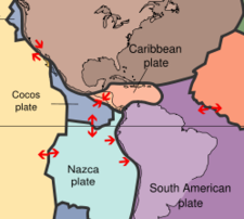
. The territory of Colombia covers vast areas within the South American plate
South American Plate
The South American Plate is a continental tectonic plate which includes the continent of South America and also a sizeable region of the Atlantic Ocean seabed extending eastward to the Mid-Atlantic Ridge....
, where most of the emerged land is, the Caribbean plate
Caribbean Plate
The Caribbean Plate is a mostly oceanic tectonic plate underlying Central America and the Caribbean Sea off the north coast of South America....
and the Nazca plate
Nazca Plate
]The Nazca Plate, named after the Nazca region of southern Peru, is an oceanic tectonic plate in the eastern Pacific Ocean basin off the west coast of South America. The ongoing subduction along the Peru-Chile Trench of the Nazca Plate under the South American Plate is largely responsible for the...
.
Emerged and Submerged zones
Colombia is formed by two great territorial zones, one submerged in the Pacific OceanPacific Ocean
The Pacific Ocean is the largest of the Earth's oceanic divisions. It extends from the Arctic in the north to the Southern Ocean in the south, bounded by Asia and Australia in the west, and the Americas in the east.At 165.2 million square kilometres in area, this largest division of the World...
and the Caribbean sea
Caribbean Sea
The Caribbean Sea is a sea of the Atlantic Ocean located in the tropics of the Western hemisphere. It is bounded by Mexico and Central America to the west and southwest, to the north by the Greater Antilles, and to the east by the Lesser Antilles....
covering a total area of 828,660 km² and the second is the emerged land which is formed by the Andes
Andes
The Andes is the world's longest continental mountain range. It is a continual range of highlands along the western coast of South America. This range is about long, about to wide , and of an average height of about .Along its length, the Andes is split into several ranges, which are separated...
mountain range and the Llanos
Llanos
The Llanos is a vast tropical grassland plain situated to the east of the Andes in Colombia and Venezuela, in northwestern South America. It is an ecoregion of the Flooded grasslands and savannas Biome....
plains that are shared with Venezuela
Venezuela
Venezuela , officially called the Bolivarian Republic of Venezuela , is a tropical country on the northern coast of South America. It borders Colombia to the west, Guyana to the east, and Brazil to the south...
and cover an area of some 1'143,748 km².
Emerged zone
In the emerged zone the region is washed by numerous rivers that include the MetaMeta River
The Meta River is formed in the Meta Department, Colombia by the confluence of the Humea, Guatiquía and Guayuriba rivers. It flows east-northeastward across the Llanos Orientales plains of Colombia through an ancient fault...
, Vichada
Vichada River
The Vichada River is a blackwater river in the country of Colombia, South America. It flows into the Orinoco River.The westward course of the Vichada is offset by an impact structure, called the Vichada Structure. The structure is most likely the largest impact structure in South America....
and the Inirida
Inírida River
-References:*Rand McNally, The New International Atlas, 1993....
rivers which contribute to other major rivers like the Orinoco River, Vaupés River
Vaupés River
Vaupés River is a tributary of the Rio Negro in South America. It arises in the Guaviare Department of Colombia, flowing east through Guaviare and Vaupés Departments. It forms part of the international border between Colombia and the Amazonas state of Brazil. On the border it merges with the...
, Caquetá River, Putumayo River
Putumayo River
The Içá or Putumayo River is one of the tributaries of the Amazon River, west of and parallel to the Yapura. It forms part of Colombia's border with Ecuador, as well as most of the frontier with Peru...
and Apaporis River. This region of the LLanos plains is also divided into three subregions;
Northern plains
the northern area characterized by its wavy plains similar to a savanna and located between the AndesAndes
The Andes is the world's longest continental mountain range. It is a continual range of highlands along the western coast of South America. This range is about long, about to wide , and of an average height of about .Along its length, the Andes is split into several ranges, which are separated...
mountain range and the Guiana Shield formed during the Tertiary
Tertiary
The Tertiary is a deprecated term for a geologic period 65 million to 2.6 million years ago. The Tertiary covered the time span between the superseded Secondary period and the Quaternary...
mostly covered with sand and clay, while the rivers contributed with sedimentary elements from the Andes during the Quaternary
Quaternary
The Quaternary Period is the most recent of the three periods of the Cenozoic Era in the geologic time scale of the ICS. It follows the Neogene Period, spanning 2.588 ± 0.005 million years ago to the present...
.
Macarena mountains area
The second region is located in the central area of the Llanos plains with a more wavy topography and formations elevated like the Alto del Vaupés or the Serranía de la MacarenaSerranía de la Macarena
Serranía de la Macarena is a Colombian mountain range located east of the Andes in the Meta Department. The mountains are separated by about 40 kilometers at their northern extreme from the Cordillera Oriental . The range is orientated from north to south and is 120 kilometers in length and 30...
mountain range, isolated in the middle of the plains and towards the Guyana Shield.
Southern area
The southern area is made up by most of the Putumayo and Amazon RiverAmazon River
The Amazon of South America is the second longest river in the world and by far the largest by waterflow with an average discharge greater than the next seven largest rivers combined...
basins, while the topography is flatter that the other two regions, this area is covered by dense jungle
Jungle
A Jungle is an area of land in the tropics overgrown with dense vegetation.The word jungle originates from the Sanskrit word jangala which referred to uncultivated land. Although the Sanskrit word refers to "dry land", it has been suggested that an Anglo-Indian interpretation led to its...
and makes up most of the Amazon Region of Colombia
Amazon Region of Colombia
The Amazonía Region is a region in southern Colombia. It comprises the departments of Amazonas, Caquetá, Guainía, Guaviare, Putumayo and Vaupés, and covers an area of 403,000 km², 35% of Colombia's total territory...
.
The Andean region
The Andean Region of ColombiaAndean Region of Colombia
The Andes mountains form the most populated region of Colombia and contain the majority of the country's urban centres. They were also the location of the most significant pre-Columbian indigenous settlement...
is the other emerged area of the two areas that compose the geology of Colombia. This area originated after a complex geological development that started in the Paleozoic
Paleozoic
The Paleozoic era is the earliest of three geologic eras of the Phanerozoic eon, spanning from roughly...
era when the Nazca plate
Nazca Plate
]The Nazca Plate, named after the Nazca region of southern Peru, is an oceanic tectonic plate in the eastern Pacific Ocean basin off the west coast of South America. The ongoing subduction along the Peru-Chile Trench of the Nazca Plate under the South American Plate is largely responsible for the...
collapsed with the South American plate
South American Plate
The South American Plate is a continental tectonic plate which includes the continent of South America and also a sizeable region of the Atlantic Ocean seabed extending eastward to the Mid-Atlantic Ridge....
pushing it under the Caribbean plate
Caribbean Plate
The Caribbean Plate is a mostly oceanic tectonic plate underlying Central America and the Caribbean Sea off the north coast of South America....
that created volcanic islands off the Pacific coast off Colombia and the isthmus of Panama
Isthmus of Panama
The Isthmus of Panama, also historically known as the Isthmus of Darien, is the narrow strip of land that lies between the Caribbean Sea and the Pacific Ocean, linking North and South America. It contains the country of Panama and the Panama Canal...
. The Colombian Massif
Colombian Massif
The Colombian Massif also known colloquially as Nudo de Almaguer refers to a group of mountains within the Andes of south central Colombia. The massif is mainly within the area of the Cauca, Huila, and Nariño Departments...
, near the border with Ecuador
Ecuador
Ecuador , officially the Republic of Ecuador is a representative democratic republic in South America, bordered by Colombia on the north, Peru on the east and south, and by the Pacific Ocean to the west. It is one of only two countries in South America, along with Chile, that do not have a border...
formed and split into three mountain ranges; Cordillera Central (central mountain range), Cordillera Oriental (Eastern mountain range) and the Cordillera Occidental (Western mountain range), each product of three different formation processes and divided from one another by valleys.
The Cordillera Oriental was the most recently formed mountain range of the three, developing by the end of the tertiary
Tertiary
The Tertiary is a deprecated term for a geologic period 65 million to 2.6 million years ago. The Tertiary covered the time span between the superseded Secondary period and the Quaternary...
period and consisting mostly of sedimentary elements. The formation of the Cordillera Oriental covered the continental platform with pelagic sediments
Pelagic sediments
Pelagic sediment or pelagite is a fine-grained sediment that has accumulated by the settling of particles through the water column to the ocean floor beneath the open ocean far from land. These particles consist primarily of either the microscopic, calcareous or siliceous shells of phytoplankton or...
with Precambrian
Precambrian
The Precambrian is the name which describes the large span of time in Earth's history before the current Phanerozoic Eon, and is a Supereon divided into several eons of the geologic time scale...
and Paleozoic
Paleozoic
The Paleozoic era is the earliest of three geologic eras of the Phanerozoic eon, spanning from roughly...
metamorphic rocks bases. The area of the Bogotá Savanna and the highland of Cundinamarca
Cundinamarca Department
- Origin of the name :The name of Cundinamarca comes from Kundur marqa, an indigenous expression, probably derived from Quechua. Meaning "Condor's Nest", it was used in pre-Columbian times by the natives of the Magdalena Valley to refer to the nearby highlands....
and Boyacá
Boyacá Department
Boyacá is one of the 32 Departments of Colombia, and the remnant of one of the original nine states of the "United States of Colombia".Boyacá is centrally located within Colombia, almost entirely within the mountains of the Eastern Cordillera to the border with Venezuela, although the western end...
tableland. To the northeast the volcanic metamorphic formed massif in Santander
Santander Department
Santander is a department of Colombia. Santander inherited the name of one of the nine original states of the United States of Colombia. It is located in the central northern part of the country, east of the Magdalena River, bordered to the south and southeast by Boyacá, to the northeast by Norte...
and Norte de Santander formed the Andes in Venezuela and the mountain ranges of Perijá
Serrania del Perija
The Serranía del Perijá, Cordillera de Perijá or Sierra de Perijá is a mountain range, an extension of the eastern Andean branch , in northern South America, between Colombia and Venezuela, ending further north in the Guajira Desert, a total distance of about 310 km...
and Motilones, between the border of Colombia and Venezuela during the Pleistocene and added sedimentary rocks during the Mesozoic.
The Cordillera Central formed from the Guyana shield during the Paleozoic era with intrusions from granite and metamorphism. To the west presents basic volcanic rocks from the end of the Cretaceous period and diorite
Diorite
Diorite is a grey to dark grey intermediate intrusive igneous rock composed principally of plagioclase feldspar , biotite, hornblende, and/or pyroxene. It may contain small amounts of quartz, microcline and olivine. Zircon, apatite, sphene, magnetite, ilmenite and sulfides occur as accessory...
intrusive rocks from the Tertiary
Tertiary
The Tertiary is a deprecated term for a geologic period 65 million to 2.6 million years ago. The Tertiary covered the time span between the superseded Secondary period and the Quaternary...
. To the west there are metamorphic Paleozoic rocks and two major massifs in Ibagué
Ibagué
Ibagué is the capital of the department of Tolima in Colombia. It is situated 1,285 m above sea level, on the eastern slopes of the Cordillera Central between the Chipalo and Combeima rivers, tributaries of the Coello River...
and the Serranía de San Lucas. Another important formation is the Baudó Mountains
Baudó Mountains
The Baudó Mountains are a coastal mountain range on the Pacific coast of Colombia. They are separated from the Cordillera Occidental by the Atrato valley where the Atrato River flows and Quibdó is located. From the south the range extends from the Baudó River north and slightly west along the...
to the west of the country.
See also
- Natural Regions of ColombiaNatural regions of ColombiaBecause of its natural structure, Colombia can be divided into six very distinct natural regions. These consist of the Andean region, covering the three branches of the Andes mountains found in Colombia; the Caribbean region, covering the area adjacent to the Caribbean sea; the Pacific region...
- Geography of ColombiaGeography of ColombiaThe geography of Colombia is characterized by containing five main natural regions that present their own unique characteristics, from the Andes mountain range region shared with Ecuador and Venezuela; the Pacific Ocean coastal region shared with Panama and Ecuador; the Caribbean Sea coastal region...
- Climate of ColombiaClimate of ColombiaThe Climate of Colombia is characterized for being tropical and isothermal as a result of its geographical location near the Equator presenting variations within five natural regions and depending on the altitude, temperature, humidity, winds and rainfall...
- List of volcanoes in Colombia