

Geologic modelling
Encyclopedia
Geologic modelling or Geomodelling is the applied science of creating computerized representations of portions of the Earth's crust
based on geophysical and geological observations made on and below the Earth surface. A Geomodel is the numerical equivalent of a three-dimensional geological map complemented by a description of physical quantities in the domain of interest. Geomodeling is related to the concept of Shared Earth Model which is a pluridisciplinary, interoperable and updatable knowledge base about the subsurface.
Geomodeling is commonly used for managing natural resources and natural hazards and quantifying geological processes, with main applications to oil
and gas fields, groundwater aquifer
s and ore
deposits. For example, in the oil and gas industry, realistic geologic models are required as input to reservoir simulator programs, which predict the behavior of the rocks under various hydrocarbon
recovery scenarios. An actual reservoir can only be developed and produced once, and mistakes can be tragic and wasteful. Using geological models and reservoir simulation
allows reservoir engineers to identify which recovery options offer the safest and most economic, efficient, and effective development plan for a particular reservoir.
Geologic modelling is a relatively recent subdiscipline of geology
which integrates structural geology
, sedimentology
, stratigraphy
, paleoclimatology
, and diagenesis
;
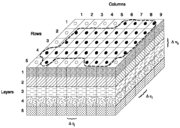
In 2 dimensions a geologic formation
or unit is represented by a polygon, which can be bounded by faults, unconformities or by its lateral extent, or crop. In geological models a geological unit is bounded by 3-dimensional triangulated or gridded surfaces. The equivalent to the mapped polygon is the fully enclosed geological unit, using a triangulated mesh. For the purpose of property or fluid modelling these volumes can be separated further into an array of cells, often referred to as voxel
s (volumetric elements). These 3D grids are the equivalent to 2D grids used to express properties of single surfaces.
Geomodeling generally involves the following steps:
, and erosion
(unconformities
). The major stratigraphic divisions are further subdivided into layers of cells with differing geometries with relation to the bounding surfaces (parallel to top, parallel to base, proportional). Maximum cell dimensions are dictated by the minimum sizes of the features to be resolved (everyday example: On a digital map of a city, the location of a city park might be adequately resolved by one big green pixel, but to define the locations of the basketball court, the baseball field, and the pool, much smaller pixels - higher resolution - need to be used).
sand, intermediate water energy marine lower shoreface
sand, and deeper low energy marine silt
and shale
. The distribution of these rock types within the model is controlled by several methods, including map boundary polygons, rock type probability maps, or statistically emplaced based on sufficiently closely spaced well data.
and permeability
, but may include measures of clay content, cementation factors, and other factors that affect the storage and deliverability of fluids contained in the pores of those rocks. Geostatistical
techniques are most often used to populate the cells with porosity and permeability values that are appropriate for the rock type of each cell.
 Most rock is completely saturated
with groundwater
. Sometimes, under the right conditions, some of the pore space in the rock is occupied by other liquids or gases. In the energy industry, oil
and natural gas
are the fluids most commonly being modelled. The preferred methods for calculating hydrocarbon saturations in a geologic model incorporate an estimate of pore throat size, the densities
of the fluids, and the height of the cell above the water contact
, since these factors exert the strongest influence on capillary action
, which ultimately controls fluid saturations.
. In order to represent the observed data, often
not on regular grids, we have to use certain interpolation techniques. The most widely used technique is kriging
which uses the spatial correlation among data and intends to construct the intepolation via semi-variograms. To reproduce more realistics spatial variability and help assessing spatial uncertainty between data, geostatistical simulation is often used, based on variograms, training images or parametric geological objects.
, Java
or C# on one or multiple computer platforms. The graphical user interface generally consists of one or several 3D and 2D graphics windows to visualize spatial data, interpretations and modeling output. Such visualization is generally achieved by exploiting graphics hardware
. User interaction is mostly performed through mouse and keyboard, although 3D pointing devices and immersive environments
may be used in some specific cases.
Geometric objects are represented with parameteric curves and surfaces or discrete models such as polygonal meshes
.
routines communicating directly with plotting hardware
. The advent of workstations with 3D graphics capabilities during the 80's gave birth to a new generation of geomodeling software with graphical user interface which became mature during the 90's.
Since its inception, geomodeling has been mainly motivated and supported by oil and gas industry.
Packages include:
Groundwater modelling
Moreover, industry Consortia or companies are specifically working at improving standardization and interoperability of earth science databases and geomodeling software:
Crust (geology)
In geology, the crust is the outermost solid shell of a rocky planet or natural satellite, which is chemically distinct from the underlying mantle...
based on geophysical and geological observations made on and below the Earth surface. A Geomodel is the numerical equivalent of a three-dimensional geological map complemented by a description of physical quantities in the domain of interest. Geomodeling is related to the concept of Shared Earth Model which is a pluridisciplinary, interoperable and updatable knowledge base about the subsurface.
Geomodeling is commonly used for managing natural resources and natural hazards and quantifying geological processes, with main applications to oil
Petroleum
Petroleum or crude oil is a naturally occurring, flammable liquid consisting of a complex mixture of hydrocarbons of various molecular weights and other liquid organic compounds, that are found in geologic formations beneath the Earth's surface. Petroleum is recovered mostly through oil drilling...
and gas fields, groundwater aquifer
Aquifer
An aquifer is a wet underground layer of water-bearing permeable rock or unconsolidated materials from which groundwater can be usefully extracted using a water well. The study of water flow in aquifers and the characterization of aquifers is called hydrogeology...
s and ore
Ore
An ore is a type of rock that contains minerals with important elements including metals. The ores are extracted through mining; these are then refined to extract the valuable element....
deposits. For example, in the oil and gas industry, realistic geologic models are required as input to reservoir simulator programs, which predict the behavior of the rocks under various hydrocarbon
Hydrocarbon
In organic chemistry, a hydrocarbon is an organic compound consisting entirely of hydrogen and carbon. Hydrocarbons from which one hydrogen atom has been removed are functional groups, called hydrocarbyls....
recovery scenarios. An actual reservoir can only be developed and produced once, and mistakes can be tragic and wasteful. Using geological models and reservoir simulation
Reservoir simulation
Reservoir simulation is an area of reservoir engineering in which computer models are used to predict the flow of fluids through porous media.-Uses:...
allows reservoir engineers to identify which recovery options offer the safest and most economic, efficient, and effective development plan for a particular reservoir.
Geologic modelling is a relatively recent subdiscipline of geology
Geology
Geology is the science comprising the study of solid Earth, the rocks of which it is composed, and the processes by which it evolves. Geology gives insight into the history of the Earth, as it provides the primary evidence for plate tectonics, the evolutionary history of life, and past climates...
which integrates structural geology
Structural geology
Structural geology is the study of the three-dimensional distribution of rock units with respect to their deformational histories. The primary goal of structural geology is to use measurements of present-day rock geometries to uncover information about the history of deformation in the rocks, and...
, sedimentology
Sedimentology
Sedimentology encompasses the study of modern sediments such as sand, mud , and clay, and the processes that result in their deposition. Sedimentologists apply their understanding of modern processes to interpret geologic history through observations of sedimentary rocks and sedimentary...
, stratigraphy
Stratigraphy
Stratigraphy, a branch of geology, studies rock layers and layering . It is primarily used in the study of sedimentary and layered volcanic rocks....
, paleoclimatology
Paleoclimatology
Paleoclimatology is the study of changes in climate taken on the scale of the entire history of Earth. It uses a variety of proxy methods from the Earth and life sciences to obtain data previously preserved within rocks, sediments, ice sheets, tree rings, corals, shells and microfossils; it then...
, and diagenesis
Diagenesis
In geology and oceanography, diagenesis is any chemical, physical, or biological change undergone by a sediment after its initial deposition and during and after its lithification, exclusive of surface alteration and metamorphism. These changes happen at relatively low temperatures and pressures...
;
In 2 dimensions a geologic formation
Geologic formation
A formation or geological formation is the fundamental unit of lithostratigraphy. A formation consists of a certain number of rock strata that have a comparable lithology, facies or other similar properties...
or unit is represented by a polygon, which can be bounded by faults, unconformities or by its lateral extent, or crop. In geological models a geological unit is bounded by 3-dimensional triangulated or gridded surfaces. The equivalent to the mapped polygon is the fully enclosed geological unit, using a triangulated mesh. For the purpose of property or fluid modelling these volumes can be separated further into an array of cells, often referred to as voxel
Voxel
A voxel is a volume element, representing a value on a regular grid in three dimensional space. This is analogous to a pixel, which represents 2D image data in a bitmap...
s (volumetric elements). These 3D grids are the equivalent to 2D grids used to express properties of single surfaces.
Geomodeling generally involves the following steps:
- Preliminary analysis of geological context of the domain of study.
- Interpretation of available data and observations as point sets or polygonal lines (e.g. "fault sticks" corresponding to faults on a vertical seismic section).
- Construction of a structural model describing the main rock boundaries (horizons, unconformities, intrusions, faults)
- Definition of a three-dimensional mesh honoring the structural model to support volumetric representation of heterogeneity (see GeostatisticsGeostatisticsGeostatistics is a branch of statistics focusing on spatial or spatiotemporal datasets. Developed originally to predict probability distributions of ore grades for mining operations, it is currently applied in diverse disciplines including petroleum geology, hydrogeology, hydrology, meteorology,...
) and solving the Partial Differential EquationsPartial differential equationIn mathematics, partial differential equations are a type of differential equation, i.e., a relation involving an unknown function of several independent variables and their partial derivatives with respect to those variables...
which govern physical processes in the subsurface (e.g. seismic wave propagationSeismologySeismology is the scientific study of earthquakes and the propagation of elastic waves through the Earth or through other planet-like bodies. The field also includes studies of earthquake effects, such as tsunamis as well as diverse seismic sources such as volcanic, tectonic, oceanic,...
, fluid transport in porous media).
Structural framework
Incorporating the spatial positions of the major boundaries of the formations, including the effects of faulting, foldingFold (geology)
The term fold is used in geology when one or a stack of originally flat and planar surfaces, such as sedimentary strata, are bent or curved as a result of permanent deformation. Synsedimentary folds are those due to slumping of sedimentary material before it is lithified. Folds in rocks vary in...
, and erosion
Erosion
Erosion is when materials are removed from the surface and changed into something else. It only works by hydraulic actions and transport of solids in the natural environment, and leads to the deposition of these materials elsewhere...
(unconformities
Unconformity
An unconformity is a buried erosion surface separating two rock masses or strata of different ages, indicating that sediment deposition was not continuous. In general, the older layer was exposed to erosion for an interval of time before deposition of the younger, but the term is used to describe...
). The major stratigraphic divisions are further subdivided into layers of cells with differing geometries with relation to the bounding surfaces (parallel to top, parallel to base, proportional). Maximum cell dimensions are dictated by the minimum sizes of the features to be resolved (everyday example: On a digital map of a city, the location of a city park might be adequately resolved by one big green pixel, but to define the locations of the basketball court, the baseball field, and the pool, much smaller pixels - higher resolution - need to be used).
Rock type
Each cell in the model is assigned a rock type. In a coastal clastic environment, these might be beach sand, high water energy marine upper shorefaceUpper shoreface
Upper Shoreface refers to the portion of the seafloor that is shallow enough to be agitated by everyday wave action . Below that is lower shoreface.-Overview:...
sand, intermediate water energy marine lower shoreface
Lower shoreface
Lower Shoreface refers to the portion of the seafloor or sedimentary depositional environment that lies below everyday wave base . In this portion of the coastal environment, only the larger waves produced during storms have the power to agitate the sea bottom...
sand, and deeper low energy marine silt
Silt
Silt is granular material of a size somewhere between sand and clay whose mineral origin is quartz and feldspar. Silt may occur as a soil or as suspended sediment in a surface water body...
and shale
Shale
Shale is a fine-grained, clastic sedimentary rock composed of mud that is a mix of flakes of clay minerals and tiny fragments of other minerals, especially quartz and calcite. The ratio of clay to other minerals is variable. Shale is characterized by breaks along thin laminae or parallel layering...
. The distribution of these rock types within the model is controlled by several methods, including map boundary polygons, rock type probability maps, or statistically emplaced based on sufficiently closely spaced well data.
Reservoir quality
Reservoir quality parameters almost always include porosityPorosity
Porosity or void fraction is a measure of the void spaces in a material, and is a fraction of the volume of voids over the total volume, between 0–1, or as a percentage between 0–100%...
and permeability
Permeability (fluid)
Permeability in fluid mechanics and the earth sciences is a measure of the ability of a porous material to allow fluids to pass through it.- Units :...
, but may include measures of clay content, cementation factors, and other factors that affect the storage and deliverability of fluids contained in the pores of those rocks. Geostatistical
Geostatistics
Geostatistics is a branch of statistics focusing on spatial or spatiotemporal datasets. Developed originally to predict probability distributions of ore grades for mining operations, it is currently applied in diverse disciplines including petroleum geology, hydrogeology, hydrology, meteorology,...
techniques are most often used to populate the cells with porosity and permeability values that are appropriate for the rock type of each cell.
Fluid saturation
Aquifer
An aquifer is a wet underground layer of water-bearing permeable rock or unconsolidated materials from which groundwater can be usefully extracted using a water well. The study of water flow in aquifers and the characterization of aquifers is called hydrogeology...
with groundwater
Groundwater
Groundwater is water located beneath the ground surface in soil pore spaces and in the fractures of rock formations. A unit of rock or an unconsolidated deposit is called an aquifer when it can yield a usable quantity of water. The depth at which soil pore spaces or fractures and voids in rock...
. Sometimes, under the right conditions, some of the pore space in the rock is occupied by other liquids or gases. In the energy industry, oil
Petroleum
Petroleum or crude oil is a naturally occurring, flammable liquid consisting of a complex mixture of hydrocarbons of various molecular weights and other liquid organic compounds, that are found in geologic formations beneath the Earth's surface. Petroleum is recovered mostly through oil drilling...
and natural gas
Natural gas
Natural gas is a naturally occurring gas mixture consisting primarily of methane, typically with 0–20% higher hydrocarbons . It is found associated with other hydrocarbon fuel, in coal beds, as methane clathrates, and is an important fuel source and a major feedstock for fertilizers.Most natural...
are the fluids most commonly being modelled. The preferred methods for calculating hydrocarbon saturations in a geologic model incorporate an estimate of pore throat size, the densities
Density
The mass density or density of a material is defined as its mass per unit volume. The symbol most often used for density is ρ . In some cases , density is also defined as its weight per unit volume; although, this quantity is more properly called specific weight...
of the fluids, and the height of the cell above the water contact
Water contact
Water contact is a term used in the hydrocarbon industry to describe the elevation above which fluids other than water can be found in the pores of a rock....
, since these factors exert the strongest influence on capillary action
Capillary action
Capillary action, or capilarity, is the ability of a liquid to flow against gravity where liquid spontanously rise in a narrow space such as between the hair of a paint-brush, in a thin tube, or in porous material such as paper or in some non-porous material such as liquified carbon fiber, or in a...
, which ultimately controls fluid saturations.
Geostatistics
An important part of geologic modelling is related to geostatisticsGeostatistics
Geostatistics is a branch of statistics focusing on spatial or spatiotemporal datasets. Developed originally to predict probability distributions of ore grades for mining operations, it is currently applied in diverse disciplines including petroleum geology, hydrogeology, hydrology, meteorology,...
. In order to represent the observed data, often
not on regular grids, we have to use certain interpolation techniques. The most widely used technique is kriging
Kriging
Kriging is a group of geostatistical techniques to interpolate the value of a random field at an unobserved location from observations of its value at nearby locations....
which uses the spatial correlation among data and intends to construct the intepolation via semi-variograms. To reproduce more realistics spatial variability and help assessing spatial uncertainty between data, geostatistical simulation is often used, based on variograms, training images or parametric geological objects.
Mineral Deposits
Mining geologists use modelling to determine the geometry and placement of mineral deposits in the subsurface of the earth. They then determine the concentration and volumes of the minerals investigated. Economic constraints are applied to the model determining the value of mineralization. Plans for mineral extraction are made determined by the ability of the miner to make an economic extraction of the defined ore.Technology
Geomodeling and CAD share a lot of common technologies. Software is usually implemented using object-oriented programming technologies in C++C++
C++ is a statically typed, free-form, multi-paradigm, compiled, general-purpose programming language. It is regarded as an intermediate-level language, as it comprises a combination of both high-level and low-level language features. It was developed by Bjarne Stroustrup starting in 1979 at Bell...
, Java
Java (programming language)
Java is a programming language originally developed by James Gosling at Sun Microsystems and released in 1995 as a core component of Sun Microsystems' Java platform. The language derives much of its syntax from C and C++ but has a simpler object model and fewer low-level facilities...
or C# on one or multiple computer platforms. The graphical user interface generally consists of one or several 3D and 2D graphics windows to visualize spatial data, interpretations and modeling output. Such visualization is generally achieved by exploiting graphics hardware
Graphics hardware
Graphics hardware is a hardware that enable to produce and show computer graphics. It works in conjuntion with graphics software. Examples of graphics hardware are display devices, graphics cards and motion capture hardware....
. User interaction is mostly performed through mouse and keyboard, although 3D pointing devices and immersive environments
Cave Automatic Virtual Environment
A Cave Automatic Virtual Environment is an immersive virtual reality environment where projectors are directed to three, four, five or six of the walls of a room-sized cube...
may be used in some specific cases.
Geometric objects are represented with parameteric curves and surfaces or discrete models such as polygonal meshes
Polygon mesh
A polygon mesh or unstructured grid is a collection of vertices, edges and faces that defines the shape of a polyhedral object in 3D computer graphics and solid modeling...
.
Research in Geomodeling
Problems pertainting to Geomodeling cover:- Defining an appropriate Ontology to describe geological objects at various scales of interest
- Integrating diverse types of observations into 3D geomodels: geological mapping data, borehole data and interpretations, seismic images and interpretations, potential field data, well test data, etc.
- Better accounting for geological processes during model building
- Characterizing uncertainty about the geomodels to help assess risk. Therefore, Geomodeling has a close connection to GeostatisticsGeostatisticsGeostatistics is a branch of statistics focusing on spatial or spatiotemporal datasets. Developed originally to predict probability distributions of ore grades for mining operations, it is currently applied in diverse disciplines including petroleum geology, hydrogeology, hydrology, meteorology,...
and Inverse problem theoryInverse problemAn inverse problem is a general framework that is used to convert observed measurements into information about a physical object or system that we are interested in...
.
History
In the 70's, geomodeling mainly consisted of automatic 2D cartographic techniques such as contouring, implemented as FORTRANFortran
Fortran is a general-purpose, procedural, imperative programming language that is especially suited to numeric computation and scientific computing...
routines communicating directly with plotting hardware
Plotter
A plotter is a computer printing device for printing vector graphics. In the past, plotters were widely used in applications such as computer-aided design, though they have generally been replaced with wide-format conventional printers...
. The advent of workstations with 3D graphics capabilities during the 80's gave birth to a new generation of geomodeling software with graphical user interface which became mature during the 90's.
Since its inception, geomodeling has been mainly motivated and supported by oil and gas industry.
Geologic modelling software
Software developers have built several packages for geologic modelling purposes. Such software can display, edit, digitise and automatically calculate the parameters required by engineers, geologists and surveyors. Current software is mainly developed and commercialized by oil and gas or mining industry software vendors:Packages include:
- Paradigm Gocad and SKUA
- Geocap
- Landmark Graphics CorporationLandmark Graphics CorporationLandmark Graphics Corporation was created in Houston in 1982 by John Mouton, Andy Hildebrand, H. Roice Nelson, and Bob Limbaugh, to develop one of the first systems for interpreting 3D data from seismic surveys for the oil and gas industry. At first the company designed and built the 3D software...
DecisionSpace Earth Modeling - Roxar IRAP RMS SuiteIRAP RMS SuiteThe Roxar RMS Suite is a software toolkit for geomodelling and designing reservoirs. It is primarily designed for use in the oilfield industry, helping engineers gather data from a wide variety of sources to efficiently build reliable reservoirs...
- Dynamic Graphics Inc. EarthVision
- Jewel Suite by JOA Oil&Gas
- Geomodeller3DGeomodeller3DGeomodeller3D is a methodology and associated software tool for 3D geologic modelling developed by BRGM over the last 15 years. The software is written using Open CASCADE in C++ for the engine , Java for the GUI and data are stored in extensible mark-up language XML...
, Intrepid Geophysics - GSI3DGSI3DGSI3D is a methodology and associated software tool for 3D geologic modeling developed by Hans-Georg Sobisch over the last 17 years initially in collaboration with the Geological Survey of Lower Saxony...
- Schlumberger PetrelPetrel (reservoir software)Petrel is a Schlumberger owned Windows PC software application intended to aggregate oil reservoir data from multiple sources. It allows the user to interpret seismic data, perform well correlation, build reservoir models suitable for simulation, submit and visualize simulation results, calculate...
- FastTracker (Reservoir Modelling)
- ArcGISArcGISArcGIS is a suite consisting of a group of geographic information system software products produced by Esri.ArcGIS is a system for working with maps and geographic information...
- Aranz Geo Ltd Leapfrog
- Gemcom Software International Surpac and GEMS (GMP)
- Gemcom Software International Minex (stratified deposits GMP)
Groundwater modelling
- FEFLOWFEFLOWFEFLOW is a computer program for simulating groundwater flow, mass transfer and heat transfer in porous media...
- FEHMFEHMFEHM is a groundwater model that has been developed in the at Los Alamos National Laboratory over the past 30 years. The executable is available free at the . The capabilities of the code have expanded over the years to include multiphase flow of heat and mass with air, water, and CO2, methane...
- MODFLOWMODFLOWMODFLOW is the U.S. Geological Survey modular finite-difference flow model, which is a computer code that solves the groundwater flow equation. The program is used by hydrogeologists to simulate the flow of groundwater through aquifers...
- GMS
- Visual MODFLOWVisual MODFLOWVisual MODFLOW is a graphical interface for MODFLOW. The program also combines proprietary extensions, such as MODFLOW-SURFACT, MT3DMS and a 3D model explorer. Visual MODFLOW supports MODFLOW-2000, MODFLOW-2005, MODFLOW-SURFACT, and SEAWAT.The software is used primarily by hydrogeologists to...
- ZOOMQ3DZOOMQ3DZOOMQ3D is a numerical finite-difference model, which simulates groundwater flow in aquifers. The program is used by hydrogeologists to investigate groundwater resources and to make predictions about possible future changes in their quantity and quality...
Moreover, industry Consortia or companies are specifically working at improving standardization and interoperability of earth science databases and geomodeling software:
- Standardization: GeoSciMLGeoSciMLGeoSciML or Geoscience Markup Language is a GML Application Schema that can be used to transfer information about geology, with an emphasis on the "interpreted geology" that is conventionally portrayed on geologic maps...
by the Commission for the Management and Application of Geoscience Information, of the International Union of Geological Sciences. - Standardization: RESQMLRESQMLRESQML is a family of XML and Web Services based upstream oil and natural gas industry standards from Energistics and its RESQML Special Interest Group ....
(tm) by Energistics - Interoperability: OpenSpirit, by TIBCO(r)
External links
Further resources and information about geomodeling may be obtained from:- American Association of Petroleum Geologists
- Geomodeling Division of the Canadian Society of Petroleum Geologists
- International Association of Mathematical Geosciences
- Gocad Consortium
- Society of Exploration Geophysicists
- Society of Petroleum Engineers
- Geomodeling Network on LinkedIn