
Geography of the United States
Encyclopedia
 |
|
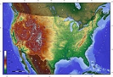
| Relief map of the 48 states of the U.S. mainland | |
| Area | |
| Total | 3,717,813 sq mi 9,629,090 km2 |
| Land | 3,536,294 sq mi 9,158,960 km2 |
| Water | 181,519 sq mi 470,131 km² |
| Latitude | 38°0' N |
| Longitude | 97°0'W |
| Borders | |
| Canada Canada Canada is a North American country consisting of ten provinces and three territories. Located in the northern part of the continent, it extends from the Atlantic Ocean in the east to the Pacific Ocean in the west, and northward into the Arctic Ocean... |
5,526 miles 8,893 km |
| Mexico Mexico The United Mexican States , commonly known as Mexico , is a federal constitutional republic in North America. It is bordered on the north by the United States; on the south and west by the Pacific Ocean; on the southeast by Guatemala, Belize, and the Caribbean Sea; and on the east by the Gulf of... |
2,067 miles 3,327 km |
| Coastlines | 12,380 miles 19,920 km |
| Maritime claims | |
| Contiguous zone | 24 nmi (44.4 km; 27.6 mi) |
| Economic zone | 200 nmi (370.4 km; 230.2 mi) |
| Territorial sea | 12 nmi (22.2 km; 13.8 mi) |
The United States
United States
The United States of America is a federal constitutional republic comprising fifty states and a federal district...
is a country
Country
A country is a region legally identified as a distinct entity in political geography. A country may be an independent sovereign state or one that is occupied by another state, as a non-sovereign or formerly sovereign political division, or a geographic region associated with a previously...
in the Western Hemisphere
Western Hemisphere
The Western Hemisphere or western hemisphere is mainly used as a geographical term for the half of the Earth that lies west of the Prime Meridian and east of the Antimeridian , the other half being called the Eastern Hemisphere.In this sense, the western hemisphere consists of the western portions...
. It consists of forty-eight contiguous states
U.S. state
A U.S. state is any one of the 50 federated states of the United States of America that share sovereignty with the federal government. Because of this shared sovereignty, an American is a citizen both of the federal entity and of his or her state of domicile. Four states use the official title of...
in North America
North America
North America is a continent wholly within the Northern Hemisphere and almost wholly within the Western Hemisphere. It is also considered a northern subcontinent of the Americas...
, Alaska
Alaska
Alaska is the largest state in the United States by area. It is situated in the northwest extremity of the North American continent, with Canada to the east, the Arctic Ocean to the north, and the Pacific Ocean to the west and south, with Russia further west across the Bering Strait...
, a peninsula
Peninsula
A peninsula is a piece of land that is bordered by water on three sides but connected to mainland. In many Germanic and Celtic languages and also in Baltic, Slavic and Hungarian, peninsulas are called "half-islands"....
which forms the northwestern most part of North America, and Hawaii
Hawaii
Hawaii is the newest of the 50 U.S. states , and is the only U.S. state made up entirely of islands. It is the northernmost island group in Polynesia, occupying most of an archipelago in the central Pacific Ocean, southwest of the continental United States, southeast of Japan, and northeast of...
, an archipelago
Archipelago
An archipelago , sometimes called an island group, is a chain or cluster of islands. The word archipelago is derived from the Greek ἄρχι- – arkhi- and πέλαγος – pélagos through the Italian arcipelago...
in the Pacific Ocean
Pacific Ocean
The Pacific Ocean is the largest of the Earth's oceanic divisions. It extends from the Arctic in the north to the Southern Ocean in the south, bounded by Asia and Australia in the west, and the Americas in the east.At 165.2 million square kilometres in area, this largest division of the World...
. There are several United States territories
United States territory
United States territory is any extent of region under the jurisdiction of the federal government of the United States, including all waters including all U.S. Naval carriers. The United States has traditionally proclaimed the sovereign rights for exploring, exploiting, conserving, and managing its...
in the Pacific and Caribbean
Caribbean
The Caribbean is a crescent-shaped group of islands more than 2,000 miles long separating the Gulf of Mexico and the Caribbean Sea, to the west and south, from the Atlantic Ocean, to the east and north...
. The term "United States", when used in the geographical sense,
means the continental United States, Alaska, Hawaii, Puerto Rico
Puerto Rico
Puerto Rico , officially the Commonwealth of Puerto Rico , is an unincorporated territory of the United States, located in the northeastern Caribbean, east of the Dominican Republic and west of both the United States Virgin Islands and the British Virgin Islands.Puerto Rico comprises an...
,
Guam
Guam
Guam is an organized, unincorporated territory of the United States located in the western Pacific Ocean. It is one of five U.S. territories with an established civilian government. Guam is listed as one of 16 Non-Self-Governing Territories by the Special Committee on Decolonization of the United...
, and the Virgin Islands of the United States. The country shares land borders with Canada
Canada
Canada is a North American country consisting of ten provinces and three territories. Located in the northern part of the continent, it extends from the Atlantic Ocean in the east to the Pacific Ocean in the west, and northward into the Arctic Ocean...
and Mexico
Mexico
The United Mexican States , commonly known as Mexico , is a federal constitutional republic in North America. It is bordered on the north by the United States; on the south and west by the Pacific Ocean; on the southeast by Guatemala, Belize, and the Caribbean Sea; and on the east by the Gulf of...
and maritime (water) borders with Russia
Russia
Russia or , officially known as both Russia and the Russian Federation , is a country in northern Eurasia. It is a federal semi-presidential republic, comprising 83 federal subjects...
, Cuba
Cuba
The Republic of Cuba is an island nation in the Caribbean. The nation of Cuba consists of the main island of Cuba, the Isla de la Juventud, and several archipelagos. Havana is the largest city in Cuba and the country's capital. Santiago de Cuba is the second largest city...
, and The Bahamas
The Bahamas
The Bahamas , officially the Commonwealth of the Bahamas, is a nation consisting of 29 islands, 661 cays, and 2,387 islets . It is located in the Atlantic Ocean north of Cuba and Hispaniola , northwest of the Turks and Caicos Islands, and southeast of the United States...
.
Area
By total area (waterTerritorial waters
Territorial waters, or a territorial sea, as defined by the 1982 United Nations Convention on the Law of the Sea, is a belt of coastal waters extending at most from the baseline of a coastal state...
as well as land), the United States is either slightly larger or smaller than the People's Republic of China
People's Republic of China
China , officially the People's Republic of China , is the most populous country in the world, with over 1.3 billion citizens. Located in East Asia, the country covers approximately 9.6 million square kilometres...
, making it the world's third or fourth largest country. China and the United States are smaller than Russia
Russia
Russia or , officially known as both Russia and the Russian Federation , is a country in northern Eurasia. It is a federal semi-presidential republic, comprising 83 federal subjects...
and Canada
Canada
Canada is a North American country consisting of ten provinces and three territories. Located in the northern part of the continent, it extends from the Atlantic Ocean in the east to the Pacific Ocean in the west, and northward into the Arctic Ocean...
in total area, but are larger than Brazil
Brazil
Brazil , officially the Federative Republic of Brazil , is the largest country in South America. It is the world's fifth largest country, both by geographical area and by population with over 192 million people...
. By land area only (exclusive of waters), the United States is the world's third largest country, after Russia and China, with Canada fourth.
Whether the US or China is the third largest country depends on two factors: (1) The validity of China's claim on Aksai Chin
Aksai Chin
Aksai Chin is one of the two main disputed border areas between China and India, and the other is South Tibet, which comprises most of India's Arunachal Pradesh. It is administered by China as part of Hotan County in the Hotan Prefecture of Xinjiang Autonomous Region, but is also claimed by India...
and Trans-Karakoram Tract
Trans-Karakoram Tract
The Trans-Karakoram Tract is an area of nearly along both sides of the Shaksgam River, is entirely administered by the People's Republic of China as a part of Kargilik County and Taxkorgan Tajik Autonomous County in the Kashgar Prefecture of Xinjiang Autonomous Region, but claimed by Pakistan...
. Both these territories are also claimed by India, so are not counted; and (2) How US calculates its own surface area. Since the initial publishing of the World Factbook, the CIA has updated the total area of United States a number of times. From 1989 through 1996, the total area of the US was listed as 9372610 km² (3,618,785 sq mi) (land + inland water only). The listed total area changed to 9629091 km² (3,717,812.8 sq mi) in 1997 (Great Lakes area and coastal waters added), to 9631418 km² (3,718,711.3 sq mi) in 2004, to 9631420 km² (3,718,712.1 sq mi) in 2006, and to 9826630 km² (3,794,083.1 sq mi) in 2007 (territorial waters added). Currently, the CIA World Factbook gives 9826675 km² (3,794,100.4 sq mi), the United Nations Statistics Division gives 9629091 km² (3,717,812.8 sq mi), and the Encyclopædia Britannica gives 9522055 km² (3,676,486 sq mi).
General characteristics

Territorial waters
Territorial waters, or a territorial sea, as defined by the 1982 United Nations Convention on the Law of the Sea, is a belt of coastal waters extending at most from the baseline of a coastal state...
border with Russia in the northwest. The contiguous forty-eight states are otherwise bounded by the Pacific Ocean
Pacific Ocean
The Pacific Ocean is the largest of the Earth's oceanic divisions. It extends from the Arctic in the north to the Southern Ocean in the south, bounded by Asia and Australia in the west, and the Americas in the east.At 165.2 million square kilometres in area, this largest division of the World...
on the west, the Atlantic Ocean
Atlantic Ocean
The Atlantic Ocean is the second-largest of the world's oceanic divisions. With a total area of about , it covers approximately 20% of the Earth's surface and about 26% of its water surface area...
on the east, and the Gulf of Mexico
Gulf of Mexico
The Gulf of Mexico is a partially landlocked ocean basin largely surrounded by the North American continent and the island of Cuba. It is bounded on the northeast, north and northwest by the Gulf Coast of the United States, on the southwest and south by Mexico, and on the southeast by Cuba. In...
to the southeast. Alaska borders the Pacific Ocean to the south, the Bering Strait
Bering Strait
The Bering Strait , known to natives as Imakpik, is a sea strait between Cape Dezhnev, Chukotka Autonomous Okrug, Russia, the easternmost point of the Asian continent and Cape Prince of Wales, Alaska, USA, the westernmost point of the North American continent, with latitude of about 65°40'N,...
to the west, and the Arctic Ocean
Arctic Ocean
The Arctic Ocean, located in the Northern Hemisphere and mostly in the Arctic north polar region, is the smallest and shallowest of the world's five major oceanic divisions...
to the north, while Hawaii lies far to the southwest of the mainland in the Pacific Ocean.
Forty-eight of the states are in the single region between Canada and Mexico; this group is referred to, with varying precision and formality, as the continental or contiguous United States, and as the Lower 48. Alaska, which is not included in the term contiguous United States, is at the northwestern end of North America
North America
North America is a continent wholly within the Northern Hemisphere and almost wholly within the Western Hemisphere. It is also considered a northern subcontinent of the Americas...
, separated from the Lower 48 by Canada. The State of Hawaii is an archipelago in the Pacific Ocean. The capital city, Washington, District of Columbia
Washington, D.C.
Washington, D.C., formally the District of Columbia and commonly referred to as Washington, "the District", or simply D.C., is the capital of the United States. On July 16, 1790, the United States Congress approved the creation of a permanent national capital as permitted by the U.S. Constitution....
, is a federal district located on land donated by the state of Maryland
Maryland
Maryland is a U.S. state located in the Mid Atlantic region of the United States, bordering Virginia, West Virginia, and the District of Columbia to its south and west; Pennsylvania to its north; and Delaware to its east...
. (Virginia
Virginia
The Commonwealth of Virginia , is a U.S. state on the Atlantic Coast of the Southern United States. Virginia is nicknamed the "Old Dominion" and sometimes the "Mother of Presidents" after the eight U.S. presidents born there...
had also donated land, but it was returned in 1847.) The United States also has overseas territories with varying levels of independence and organization.
Physiographic divisions

Appalachian Mountains
The Appalachian Mountains #Whether the stressed vowel is or ,#Whether the "ch" is pronounced as a fricative or an affricate , and#Whether the final vowel is the monophthong or the diphthong .), often called the Appalachians, are a system of mountains in eastern North America. The Appalachians...
form a line of low mountains separating the eastern seaboard from the Great Lakes and the Mississippi Basin. The five Great Lakes
Great Lakes
The Great Lakes are a collection of freshwater lakes located in northeastern North America, on the Canada – United States border. Consisting of Lakes Superior, Michigan, Huron, Erie, and Ontario, they form the largest group of freshwater lakes on Earth by total surface, coming in second by volume...
are located in the north-central portion of the country, four of them forming part of the border with Canada
Canada
Canada is a North American country consisting of ten provinces and three territories. Located in the northern part of the continent, it extends from the Atlantic Ocean in the east to the Pacific Ocean in the west, and northward into the Arctic Ocean...
. The southeast United States contain subtropical forests and, near the gulf coast, mangrove
Mangrove
Mangroves are various kinds of trees up to medium height and shrubs that grow in saline coastal sediment habitats in the tropics and subtropics – mainly between latitudes N and S...
wetlands, especially in Florida
Florida
Florida is a state in the southeastern United States, located on the nation's Atlantic and Gulf coasts. It is bordered to the west by the Gulf of Mexico, to the north by Alabama and Georgia and to the east by the Atlantic Ocean. With a population of 18,801,310 as measured by the 2010 census, it...
. West of the Appalachians lies the Mississippi River
Mississippi River
The Mississippi River is the largest river system in North America. Flowing entirely in the United States, this river rises in western Minnesota and meanders slowly southwards for to the Mississippi River Delta at the Gulf of Mexico. With its many tributaries, the Mississippi's watershed drains...
basin and two large eastern tributaries, the Ohio River
Ohio River
The Ohio River is the largest tributary, by volume, of the Mississippi River. At the confluence, the Ohio is even bigger than the Mississippi and, thus, is hydrologically the main stream of the whole river system, including the Allegheny River further upstream...
and the Tennessee River
Tennessee River
The Tennessee River is the largest tributary of the Ohio River. It is approximately 652 miles long and is located in the southeastern United States in the Tennessee Valley. The river was once popularly known as the Cherokee River, among other names...
. The Ohio and Tennessee
Tennessee Valley
The Tennessee Valley is the drainage basin of the Tennessee River and is largely within the U.S. state of Tennessee. It stretches from southwest Kentucky to northwest Georgia and from northeast Mississippi to the mountains of Virginia and North Carolina...
Valleys and the Midwest consist largely of rolling hills and productive farmland, stretching south to the Gulf Coast.
The Great Plains
Great Plains
The Great Plains are a broad expanse of flat land, much of it covered in prairie, steppe and grassland, which lies west of the Mississippi River and east of the Rocky Mountains in the United States and Canada. This area covers parts of the U.S...
lie west of the Mississippi River and east of the Rocky Mountains. A large portion of the country's agricultural products are grown in the Great Plains. Before their general conversion to farmland, the Great Plains were noted for their extensive grasslands, from tallgrass prairie
Tallgrass prairie
The tallgrass prairie is an ecosystem native to central North America, with fire as its primary periodic disturbance. In the past, tallgrass prairies covered a large portion of the American Midwest, just east of the Great Plains, and portions of the Canadian Prairies. They flourished in areas with...
in the eastern plains to shortgrass steppe
Shortgrass prairie
The shortgrass prairie ecosystem of the North American Great Plains is a prairie that includes lands from the eastern foothills of the Rocky Mountains east to Nebraska and Saskatchewan, including rangelands in Alberta, Wyoming, Montana, North, South Dakota, and Kansas, and extending to the south...
in the western High Plains
High Plains (United States)
The High Plains are a subregion of the Great Plains mostly in the Western United States, but also partly in the Midwest states of Nebraska, Kansas, and South Dakota, generally encompassing the western part of the Great Plains before the region reaches the Rocky Mountains...
. Elevation rises gradually from less than a few hundred feet near the Mississippi River to more than a mile high in the High Plains. The generally low relief of the plains is broken in several places, most notably in the Ozark
The Ozarks
The Ozarks are a physiographic and geologic highland region of the central United States. It covers much of the southern half of Missouri and an extensive portion of northwestern and north central Arkansas...
and Ouachita Mountains
Ouachita Mountains
The Ouachita Mountains are a mountain range in west central Arkansas and southeastern Oklahoma. The range's subterranean roots may extend as far as central Texas, or beyond it to the current location of the Marathon Uplift. Along with the Ozark Mountains, the Ouachita Mountains form the U.S...
, which form the U.S. Interior Highlands
U.S. Interior Highlands
The U.S. Interior Highlands is a mountainous region spanning eastern Oklahoma, western and northern Arkansas, southern Missouri, and the extreme southeast corner of Kansas. The name is designated by the United States Geological Survey to refer to the combined mountainous region of the Ozarks and...
, the only major mountainous region between the Rocky Mountains
Rocky Mountains
The Rocky Mountains are a major mountain range in western North America. The Rocky Mountains stretch more than from the northernmost part of British Columbia, in western Canada, to New Mexico, in the southwestern United States...
and the Appalachian Mountains
Appalachian Mountains
The Appalachian Mountains #Whether the stressed vowel is or ,#Whether the "ch" is pronounced as a fricative or an affricate , and#Whether the final vowel is the monophthong or the diphthong .), often called the Appalachians, are a system of mountains in eastern North America. The Appalachians...
.
The Great Plains come to an abrupt end at the Rocky Mountains
Rocky Mountains
The Rocky Mountains are a major mountain range in western North America. The Rocky Mountains stretch more than from the northernmost part of British Columbia, in western Canada, to New Mexico, in the southwestern United States...
. The Rocky Mountains form a large portion of the Western U.S., entering from Canada
Canada
Canada is a North American country consisting of ten provinces and three territories. Located in the northern part of the continent, it extends from the Atlantic Ocean in the east to the Pacific Ocean in the west, and northward into the Arctic Ocean...
and stretching nearly to Mexico
Mexico
The United Mexican States , commonly known as Mexico , is a federal constitutional republic in North America. It is bordered on the north by the United States; on the south and west by the Pacific Ocean; on the southeast by Guatemala, Belize, and the Caribbean Sea; and on the east by the Gulf of...
. The Rocky Mountain region is the highest region of the United States by average elevation. The Rocky Mountains generally contain fairly mild slopes and wider peaks compared to some of the other great mountain ranges, with a few exceptions (such as the Teton Mountains in Wyoming
Wyoming
Wyoming is a state in the mountain region of the Western United States. The western two thirds of the state is covered mostly with the mountain ranges and rangelands in the foothills of the Eastern Rocky Mountains, while the eastern third of the state is high elevation prairie known as the High...
and the Sawatch Range
Sawatch Range
The Sawatch Range is a mountain range in central Colorado which includes eight of the twenty highest peaks in the Rocky Mountains, including Mount Elbert, at elevation, the highest peak in the Rockies....
in Colorado
Colorado
Colorado is a U.S. state that encompasses much of the Rocky Mountains as well as the northeastern portion of the Colorado Plateau and the western edge of the Great Plains...
). The highest peaks of the Rockies are found in Colorado, the tallest peak being Mount Elbert
Mount Elbert
Mount Elbert is the highest peak in the Rocky Mountains of North America, at , the highest of the fourteeners in Colorado, and the high point of the Sawatch Range. It is located in Lake County, approximately southwest of Leadville...
at 14440 ft (4,401.3 m). The Rocky Mountains contain some of the most spectacular, and well known scenery in the world. In addition, instead of being one generally continuous and solid mountain range, it is broken up into a number of smaller, intermittent mountain ranges, forming a large series of basins and valleys.
West of the Rocky Mountains lies the Intermontane Plateaus
Intermontane Plateaus
Physiographic regions of the U.S. InteriorSee:legendIn some places,high plateaus lie between the mountain ranges, for example,the plateau of Anatolia in Turkey and the plateau of Tibet.These are called "Intermontane plateaus"....
(also known as the Intermountain West
Intermountain West
The Intermountain West is a region of North America lying between the Rocky Mountains to the east and the Cascades and Sierra Nevada to the west. It is also called the Intermountain Region.- Topography :...
), a large, arid desert lying between the Rockies and the Cascades
Cascade Range
The Cascade Range is a major mountain range of western North America, extending from southern British Columbia through Washington and Oregon to Northern California. It includes both non-volcanic mountains, such as the North Cascades, and the notable volcanoes known as the High Cascades...
and Sierra Nevada ranges. The large southern portion, known as the Great Basin
Great Basin
The Great Basin is the largest area of contiguous endorheic watersheds in North America and is noted for its arid conditions and Basin and Range topography that varies from the North American low point at Badwater Basin to the highest point of the contiguous United States, less than away at the...
, consists of salt flats, drainage basins, and many small north-south mountain ranges. The Southwest
Southwestern United States
The Southwestern United States is a region defined in different ways by different sources. Broad definitions include nearly a quarter of the United States, including Arizona, California, Colorado, Nevada, New Mexico, Oklahoma, Texas and Utah...
is predominantly a low-lying desert region. A portion known as the Colorado Plateau
Colorado Plateau
The Colorado Plateau, also called the Colorado Plateau Province, is a physiographic region of the Intermontane Plateaus, roughly centered on the Four Corners region of the southwestern United States. The province covers an area of 337,000 km2 within western Colorado, northwestern New Mexico,...
, centered around the Four Corners region, is considered to have some of the most spectacular scenery in the world. It is accentuated in such national parks as Grand Canyon
Grand Canyon National Park
Grand Canyon National Park is the United States' 15th oldest national park and is located in Arizona. Within the park lies the Grand Canyon, a gorge of the Colorado River, considered to be one of the Wonders of the World. The park covers of unincorporated area in Coconino and Mohave counties.Most...
, Arches
Arches National Park
Arches National Park is a U.S. National Park in eastern Utah. It is known for preserving over 2000 natural sandstone arches, including the world-famous Delicate Arch, in addition to a variety of unique geological resources and formations....
, Mesa Verde National Park
Mesa Verde National Park
Mesa Verde National Park is a U.S. National Park and UNESCO World Heritage Site located in Montezuma County, Colorado, United States. It was created in 1906 to protect some of the best-preserved cliff dwellings in the world...
and Bryce Canyon
Bryce Canyon National Park
Bryce Canyon National Park is a national park located in southwestern Utah in the United States. The major feature of the park is Bryce Canyon which, despite its name, is not a canyon but a giant natural amphitheater created by erosion along the eastern side of the Paunsaugunt Plateau...
, among others.
The Intermontane Plateaus come to an end at the Cascade Range
Cascade Range
The Cascade Range is a major mountain range of western North America, extending from southern British Columbia through Washington and Oregon to Northern California. It includes both non-volcanic mountains, such as the North Cascades, and the notable volcanoes known as the High Cascades...
and the Sierra Nevada. The Cascades consist of largely intermittent, volcanic mountains, many rising prominently from the surrounding landscape. The Sierra Nevada, further south, is a high, rugged, and dense mountain range. It contains the highest point in the contiguous 48 states, Mount Whitney
Mount Whitney
Mount Whitney is the highest summit in the contiguous United States with an elevation of . It is on the boundary between California's Inyo and Tulare counties, west-northwest of the lowest point in North America at Badwater in Death Valley National Park...
(14505 ft (4,421 m)). Mount Whitney is the highest summit in the contiguous United States with an elevation of 14,505 feet (4,421 m).[1] It is located at the boundary between California's Inyo and Tulare counties, just 84.6 miles (136.2 km) west-northwest of the lowest point in North America at Badwater in Death Valley National Park (282 feet (86 m) below sea level).These areas contain some spectacular scenery as well, as evidenced by such national parks as Yosemite
Yosemite National Park
Yosemite National Park is a United States National Park spanning eastern portions of Tuolumne, Mariposa and Madera counties in east central California, United States. The park covers an area of and reaches across the western slopes of the Sierra Nevada mountain chain...
and Mount Rainier
Mount Rainier National Park
Mount Rainier National Park is a United States National Park located in southeast Pierce County and northeast Lewis County in Washington state. It was one of the US's earliest National Parks, having been established on March 2, 1899 as the fifth national park in the United States. The park contains...
. West of the Cascades and Sierra Nevada is a series of valleys, such as the Central Valley in California
California
California is a state located on the West Coast of the United States. It is by far the most populous U.S. state, and the third-largest by land area...
and the Willamette Valley
Willamette Valley
The Willamette Valley is the most populated region in the state of Oregon of the United States. Located in the state's northwest, the region is surrounded by tall mountain ranges to the east, west and south and the valley's floor is broad, flat and fertile because of Ice Age conditions...
in Oregon
Oregon
Oregon is a state in the Pacific Northwest region of the United States. It is located on the Pacific coast, with Washington to the north, California to the south, Nevada on the southeast and Idaho to the east. The Columbia and Snake rivers delineate much of Oregon's northern and eastern...
. Along the coast is a series of low mountain ranges known as the Pacific Coast Ranges
Pacific Coast Ranges
The Pacific Coast Ranges and the Pacific Mountain System are the series of mountain ranges that stretch along the West Coast of North America from Alaska south to Northern and Central Mexico...
. Much of the Pacific Northwest
Pacific Northwest
The Pacific Northwest is a region in northwestern North America, bounded by the Pacific Ocean to the west and, loosely, by the Rocky Mountains on the east. Definitions of the region vary and there is no commonly agreed upon boundary, even among Pacific Northwesterners. A common concept of the...
coast is inhabited by some of the densest vegetation outside of the Tropics
Tropics
The tropics is a region of the Earth surrounding the Equator. It is limited in latitude by the Tropic of Cancer in the northern hemisphere at approximately N and the Tropic of Capricorn in the southern hemisphere at S; these latitudes correspond to the axial tilt of the Earth...
, and also the tallest trees in the world (the Redwoods).
Alaska contains some of the most dramatic and untapped scenery in the country. Tall, prominent mountain ranges rise up sharply from broad, flat tundra plains. On the islands off the south and southwest coast are many volcanoes. Hawaii, far to the south of Alaska in the Pacific Ocean, is a chain of tropical, volcanic islands, popular as a tourist destination for many from East Asia
East Asia
East Asia or Eastern Asia is a subregion of Asia that can be defined in either geographical or cultural terms...
and the mainland United States.
The geography of the United States varies across their immense area. Within the continental U.S., eight distinct physiographic divisions exist, though each is composed of several smaller physiographic subdivisions. These major divisions are:
- Laurentian UplandLaurentian UplandThe Laurentian Upland is a physiographic province which, when referred to as the "Laurentian Region," is recognized by Natural Resources Canada as one of five provinces of the larger Canadian Shield physiographic division...
- part of the Canadian ShieldCanadian ShieldThe Canadian Shield, also called the Laurentian Plateau, or Bouclier Canadien , is a vast geological shield covered by a thin layer of soil that forms the nucleus of the North American or Laurentia craton. It is an area mostly composed of igneous rock which relates to its long volcanic history...
that extends into the northern United States Great Lakes area. - Atlantic PlainAtlantic PlainThe Atlantic Plain is one of eight distinct United States physiographic regions. This major division consists of the Continental Shelf and Coastal Plain physiographic provinces. It is the flattest of the U.S. physiographic divisions and stretches over in length from Cape Cod to the Mexican border...
- the coastal regions of the eastern and southern parts includes the continental shelf, the Atlantic CoastEast Coast of the United StatesThe East Coast of the United States, also known as the Eastern Seaboard, refers to the easternmost coastal states in the United States, which touch the Atlantic Ocean and stretch up to Canada. The term includes the U.S...
and the Gulf Coast. - Appalachian Highlands - lying on the eastern side of the United States, it includes the Appalachian MountainsAppalachian MountainsThe Appalachian Mountains #Whether the stressed vowel is or ,#Whether the "ch" is pronounced as a fricative or an affricate , and#Whether the final vowel is the monophthong or the diphthong .), often called the Appalachians, are a system of mountains in eastern North America. The Appalachians...
, the Watchung MountainsWatchung MountainsThe Watchung Mountains are a group of three long low ridges of volcanic origin, between 400 ft. and 500 ft. high, lying parallel to each other in northern New Jersey in the United States...
, the Adirondacks and New EnglandNew EnglandNew England is a region in the northeastern corner of the United States consisting of the six states of Maine, New Hampshire, Vermont, Massachusetts, Rhode Island, and Connecticut...
province originally containing the Great Eastern Forest. - Interior PlainsInterior PlainsThe Interior Plains is a vast physiographic region that spreads across the Laurentian craton of central North America.-Geography:The Interior Plains are an extensive physiographic division encompassing 8 distinct physiographic provinces, the Interior Low Plateaus, Great Plains, Central Lowland,...
- part of the interior contentintal United States, it includes much of what is called the Great Plains. - Interior Highlands - also part of the interior contentintal United States, this division includes the Ozark Plateau.
- Rocky Mountain SystemRocky MountainsThe Rocky Mountains are a major mountain range in western North America. The Rocky Mountains stretch more than from the northernmost part of British Columbia, in western Canada, to New Mexico, in the southwestern United States...
- one branch of the CordilleranAmerican cordilleraThe American Cordillera is a cordillera that consists of an essentially continuous sequence of mountain ranges that form the western "backbone" of North America, Central America, South America and Antarctica. From north to south, this sequence of overlapping and parallel ranges begins with the...
system lying far inland in the western states. - Intermontane Plateaus - also divided into the Columbia PlateauColumbia PlateauThe Columbia Plateau is a geologic and geographic region that lies across parts of the U.S. states of Washington, Oregon, and Idaho. It is a wide flood basalt plateau between the Cascade Range and the Rocky Mountains, cut through by the Columbia River...
, the Colorado PlateauColorado PlateauThe Colorado Plateau, also called the Colorado Plateau Province, is a physiographic region of the Intermontane Plateaus, roughly centered on the Four Corners region of the southwestern United States. The province covers an area of 337,000 km2 within western Colorado, northwestern New Mexico,...
and the Basin and Range Province, it is a system of plateaus, basins, ranges and gorges between the Rocky and Pacific Mountain Systems. It is the setting for the Grand CanyonGrand CanyonThe Grand Canyon is a steep-sided canyon carved by the Colorado River in the United States in the state of Arizona. It is largely contained within the Grand Canyon National Park, the 15th national park in the United States...
, the Great BasinGreat BasinThe Great Basin is the largest area of contiguous endorheic watersheds in North America and is noted for its arid conditions and Basin and Range topography that varies from the North American low point at Badwater Basin to the highest point of the contiguous United States, less than away at the...
and Death ValleyDeath ValleyDeath Valley is a desert valley located in Eastern California. Situated within the Mojave Desert, it features the lowest, driest, and hottest locations in North America. Badwater, a basin located in Death Valley, is the specific location of the lowest elevation in North America at 282 feet below...
. - Pacific Mountain SystemPacific Coast RangesThe Pacific Coast Ranges and the Pacific Mountain System are the series of mountain ranges that stretch along the West Coast of North America from Alaska south to Northern and Central Mexico...
- the coastal mountain ranges and features in the west coast of the United StatesWest Coast of the United StatesWest Coast or Pacific Coast are terms for the westernmost coastal states of the United States. The term most often refers to the states of California, Oregon, and Washington. Although not part of the contiguous United States, Alaska and Hawaii do border the Pacific Ocean but can't be included in...
.
.jpg)
Permian
The PermianThe term "Permian" was introduced into geology in 1841 by Sir Sir R. I. Murchison, president of the Geological Society of London, who identified typical strata in extensive Russian explorations undertaken with Edouard de Verneuil; Murchison asserted in 1841 that he named his "Permian...
time) that it has since then been very generally reduced to moderate or low relief. It owes its present day altitude either to renewed elevations along the earlier lines or to the survival of the most resistant rocks as residual mountains. The oblique trend of this coast would be even more pronounced but for a comparatively modern crustal movement, causing a depression in the northeast resulting in an encroachment of the sea upon the land. Additionally, the southeastern section has undergone an elevation resulting in the advance of the land upon the sea.
While the Atlantic coast is relatively low, the Pacific coast is, with few exceptions, hilly or mountainous. This coast has been defined chiefly by geologically recent crustal deformations, and hence still preserves a greater relief than that of the Atlantic. The low Atlantic coast and the hilly or mountainous Pacific coast foreshadow the leading features in the distribution of mountains within the United States. The east coast Appalachian system, originally forest covered, is relatively low and narrow and is bordered on the southeast and south by an important coastal plain. The Cordilleran system
American cordillera
The American Cordillera is a cordillera that consists of an essentially continuous sequence of mountain ranges that form the western "backbone" of North America, Central America, South America and Antarctica. From north to south, this sequence of overlapping and parallel ranges begins with the...
on the western side of the continent is lofty, broad and complicated having two branches, the Rocky Mountain System and the Pacific Mountain System. In between these mountain systems lie the Intermontaine Plateaus. Both the Columbia River
Columbia River
The Columbia River is the largest river in the Pacific Northwest region of North America. The river rises in the Rocky Mountains of British Columbia, Canada, flows northwest and then south into the U.S. state of Washington, then turns west to form most of the border between Washington and the state...
and Colorado River
Colorado River
The Colorado River , is a river in the Southwestern United States and northwestern Mexico, approximately long, draining a part of the arid regions on the western slope of the Rocky Mountains. The watershed of the Colorado River covers in parts of seven U.S. states and two Mexican states...
rise far inland near the easternmost members of the Cordilleran system, and flow through plateaus and intermontaine basins to the ocean. Heavy forests cover the northwest coast, but elsewhere trees are found only on the higher ranges below the Alpine region. The intermontane
Intermontane
Intermontane is a physiographic adjective formed from the prefix "inter-" and the adjective "montane" Usage includes intermontane basin such as New Zealand's Mackenzie Basin and intermontane...
valleys, plateaus and basins range from treeless to desert with the most arid region being in the southwest.
The Laurentian Highlands, the Interior Plains and the Interior Highlands lie between the two coasts, stretching from the Gulf of Mexico
Gulf of Mexico
The Gulf of Mexico is a partially landlocked ocean basin largely surrounded by the North American continent and the island of Cuba. It is bounded on the northeast, north and northwest by the Gulf Coast of the United States, on the southwest and south by Mexico, and on the southeast by Cuba. In...
northward, far beyond the national boundary, to the Arctic Ocean
Arctic Ocean
The Arctic Ocean, located in the Northern Hemisphere and mostly in the Arctic north polar region, is the smallest and shallowest of the world's five major oceanic divisions...
. The central plains are divided by a hardly perceptible height of land into a Canadian
Canada
Canada is a North American country consisting of ten provinces and three territories. Located in the northern part of the continent, it extends from the Atlantic Ocean in the east to the Pacific Ocean in the west, and northward into the Arctic Ocean...
and a United States portion. It is from the United States side, that the great Mississippi
Mississippi River
The Mississippi River is the largest river system in North America. Flowing entirely in the United States, this river rises in western Minnesota and meanders slowly southwards for to the Mississippi River Delta at the Gulf of Mexico. With its many tributaries, the Mississippi's watershed drains...
system discharges southward to the Gulf of Mexico. The upper Mississippi and some of the Ohio
Ohio River
The Ohio River is the largest tributary, by volume, of the Mississippi River. At the confluence, the Ohio is even bigger than the Mississippi and, thus, is hydrologically the main stream of the whole river system, including the Allegheny River further upstream...
basin is the semi-arid prairie region, with trees originally only along the watercourses. The uplands towards the Appalachians were included in the great eastern forested area, while the western part of the plains has so dry a climate that its native plant life is scanty, and in the south it is practically barren.
Elevation extremes:
- Lowest point: Death ValleyDeath ValleyDeath Valley is a desert valley located in Eastern California. Situated within the Mojave Desert, it features the lowest, driest, and hottest locations in North America. Badwater, a basin located in Death Valley, is the specific location of the lowest elevation in North America at 282 feet below...
, Inyo County, CaliforniaInyo County, California-National protected areas:* Death Valley National Park * Inyo National Forest * Manzanar National Historic Site-Major highways:* U.S. Route 6* U.S. Route 395* State Route 127* State Route 136* State Route 168* State Route 178...
-282 ft below sea levelSea levelMean sea level is a measure of the average height of the ocean's surface ; used as a standard in reckoning land elevation... - Highest point: Mount McKinleyMount McKinleyMount McKinley or Denali in Alaska, United States is the highest mountain peak in North America and the United States, with a summit elevation of above sea level. It is the centerpiece of Denali National Park and Preserve.- Geology and features :Mount McKinley is a granitic pluton...
, Denali Borough, AlaskaDenali Borough, Alaska-Demographics:As of the census of 2000, there were 1,893 people, 785 households, and 452 families residing in the borough. The population density was 0 people per square mile . There were 1,351 housing units at an average density of 0 per square mile...
20320 ft (6,194 m) above sea level
Climate
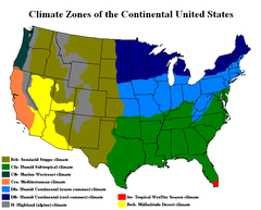
Deep South
The Deep South is a descriptive category of the cultural and geographic subregions in the American South. Historically, it is differentiated from the "Upper South" as being the states which were most dependent on plantation type agriculture during the pre-Civil War period...
, tropical in Hawaii and southern Florida
Florida
Florida is a state in the southeastern United States, located on the nation's Atlantic and Gulf coasts. It is bordered to the west by the Gulf of Mexico, to the north by Alabama and Georgia and to the east by the Atlantic Ocean. With a population of 18,801,310 as measured by the 2010 census, it...
, polar in Alaska, semiarid in the Great Plains west of the 100th meridian
100th meridian west
The meridian 100° west of Greenwich is a line of longitude that extends from the North Pole across the Arctic Ocean, North America, the Pacific Ocean, the Southern Ocean, and Antarctica to the South Pole....
, Mediterranean in coastal California
California
California is a state located on the West Coast of the United States. It is by far the most populous U.S. state, and the third-largest by land area...
and arid in the Great Basin
Great Basin
The Great Basin is the largest area of contiguous endorheic watersheds in North America and is noted for its arid conditions and Basin and Range topography that varies from the North American low point at Badwater Basin to the highest point of the contiguous United States, less than away at the...
. Its comparatively favorable agricultural climate contributed (in part) to the country's rise as a world power, with infrequent severe drought in the major agricultural regions, a general lack of widespread flooding, and a mainly temperate climate that receives adequate precipitation.
Jet stream
Jet streams are fast flowing, narrow air currents found in the atmospheres of some planets, including Earth. The main jet streams are located near the tropopause, the transition between the troposphere and the stratosphere . The major jet streams on Earth are westerly winds...
, which brings in large low pressure systems from the northern Pacific Ocean
Pacific Ocean
The Pacific Ocean is the largest of the Earth's oceanic divisions. It extends from the Arctic in the north to the Southern Ocean in the south, bounded by Asia and Australia in the west, and the Americas in the east.At 165.2 million square kilometres in area, this largest division of the World...
. The Cascade Range
Cascade Range
The Cascade Range is a major mountain range of western North America, extending from southern British Columbia through Washington and Oregon to Northern California. It includes both non-volcanic mountains, such as the North Cascades, and the notable volcanoes known as the High Cascades...
, Sierra Nevada, and Rocky Mountains
Rocky Mountains
The Rocky Mountains are a major mountain range in western North America. The Rocky Mountains stretch more than from the northernmost part of British Columbia, in western Canada, to New Mexico, in the southwestern United States...
pick up most of the moisture from these systems as they move eastward. Greatly diminished by the time they reach the High Plains, much of the moisture has been sapped by the orographic effect as it is forced over several mountain ranges. However, once it moves over the Great Plains, uninterrupted flat land allows it to reorganize and can lead to major clashes of air masses. In addition, moisture from the Gulf of Mexico
Gulf of Mexico
The Gulf of Mexico is a partially landlocked ocean basin largely surrounded by the North American continent and the island of Cuba. It is bounded on the northeast, north and northwest by the Gulf Coast of the United States, on the southwest and south by Mexico, and on the southeast by Cuba. In...
is often drawn northward. When combined with a powerful jet stream, this can lead to violent thunderstorms, especially during spring and summer. Sometimes during late winter and spring these storms can combine with another low pressure system as they move up the East Coast and into the Atlantic Ocean
Atlantic Ocean
The Atlantic Ocean is the second-largest of the world's oceanic divisions. With a total area of about , it covers approximately 20% of the Earth's surface and about 26% of its water surface area...
, where they intensify rapidly. These storms are known as Nor'easter
Nor'easter
A nor'easter is a type of macro-scale storm along the East Coast of the United States and Atlantic Canada, so named because the storm travels to the northeast from the south and the winds come from the northeast, especially in the coastal areas of the Northeastern United States and Atlantic Canada...
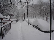
s and often bring widespread, heavy snowfall to the Mid-Atlantic
Mid-Atlantic States
The Mid-Atlantic states, also called middle Atlantic states or simply the mid Atlantic, form a region of the United States generally located between New England and the South...
and New England
New England
New England is a region in the northeastern corner of the United States consisting of the six states of Maine, New Hampshire, Vermont, Massachusetts, Rhode Island, and Connecticut...
. The uninterrupted flat grasslands of the Great Plains also leads to some of the most extreme climate swings in the world. Temperatures can rise or drop rapidly and winds can be extreme, and the flow of heat waves or Arctic air masses often advance uninterrupted through the plains.

Great Basin
The Great Basin is the largest area of contiguous endorheic watersheds in North America and is noted for its arid conditions and Basin and Range topography that varies from the North American low point at Badwater Basin to the highest point of the contiguous United States, less than away at the...
and Columbia Plateau
Columbia Plateau
The Columbia Plateau is a geologic and geographic region that lies across parts of the U.S. states of Washington, Oregon, and Idaho. It is a wide flood basalt plateau between the Cascade Range and the Rocky Mountains, cut through by the Columbia River...
(the Intermontane Plateaus
Intermontane Plateaus
Physiographic regions of the U.S. InteriorSee:legendIn some places,high plateaus lie between the mountain ranges, for example,the plateau of Anatolia in Turkey and the plateau of Tibet.These are called "Intermontane plateaus"....
) are arid or semiarid regions that lie in the rain shadow of the Cascades and Sierra Nevada. Precipitation averages less than 15 inches (38 cm). The Southwest is a hot desert, with temperatures exceeding 100 °F (37.8 °C) for several weeks at a time in summer. The Southwest and the Great Basin are also affected by the monsoon
Monsoon
Monsoon is traditionally defined as a seasonal reversing wind accompanied by corresponding changes in precipitation, but is now used to describe seasonal changes in atmospheric circulation and precipitation associated with the asymmetric heating of land and sea...
from the Gulf of California
Gulf of California
The Gulf of California is a body of water that separates the Baja California Peninsula from the Mexican mainland...
from July–September, which brings localized but often severe thunderstorms to the region.
Much of California consists of a Mediterranean climate
Mediterranean climate
A Mediterranean climate is the climate typical of most of the lands in the Mediterranean Basin, and is a particular variety of subtropical climate...
, with sometimes excessive rainfall from October–April and nearly no rain the rest of the year. In the Pacific Northwest
Pacific Northwest
The Pacific Northwest is a region in northwestern North America, bounded by the Pacific Ocean to the west and, loosely, by the Rocky Mountains on the east. Definitions of the region vary and there is no commonly agreed upon boundary, even among Pacific Northwesterners. A common concept of the...
rain falls year-round, but is much heavier during winter and spring. The mountains of the west receive abundant precipitation and very heavy snowfall. The Cascades are one of the snowiest places in the world, with some places averaging over 600 inches (1,524 cm) of snow annually, but the lower elevations closer to the coast receive very little snow. Another significant (but localized) weather effect is lake-effect snow that falls south and east of the Great Lakes
Great Lakes
The Great Lakes are a collection of freshwater lakes located in northeastern North America, on the Canada – United States border. Consisting of Lakes Superior, Michigan, Huron, Erie, and Ontario, they form the largest group of freshwater lakes on Earth by total surface, coming in second by volume...
, especially in the hilly portions of the Upper Peninsula of Michigan
Michigan
Michigan is a U.S. state located in the Great Lakes Region of the United States of America. The name Michigan is the French form of the Ojibwa word mishigamaa, meaning "large water" or "large lake"....
and on the Tug Hill Plateau
Tug Hill Plateau
The Tug Hill Plateau is an upland region in upstate New York in the USA, famous for heavy winter snow. The Tug Hill Region is west of the Adirondack Mountains and is separated from the Adirondacks by the Black River Valley. Although the region is and has traditionally been known as the Tug Hill...
in New York
New York
New York is a state in the Northeastern region of the United States. It is the nation's third most populous state. New York is bordered by New Jersey and Pennsylvania to the south, and by Connecticut, Massachusetts and Vermont to the east...
. The lake effect dumped well over 5 feet (1.52 m) of snow in the area of Buffalo, New York throughout the 2006-2007 winter. The Wasatch Front
Wasatch Front
The Wasatch Front is a metropolitan region in the north-central part of the U.S. state of Utah. It consists of a chain of cities and towns stretched along the Wasatch Range from approximately Santaquin in the south to Brigham City in the north...
and Wasatch Range
Wasatch Range
The Wasatch Range is a mountain range that stretches approximately from the Utah-Idaho border, south through central Utah in the western United States. It is generally considered the western edge of the greater Rocky Mountains, and the eastern edge of the Great Basin region...
in Utah
Utah
Utah is a state in the Western United States. It was the 45th state to join the Union, on January 4, 1896. Approximately 80% of Utah's 2,763,885 people live along the Wasatch Front, centering on Salt Lake City. This leaves vast expanses of the state nearly uninhabited, making the population the...
can also receive significant lake effect accumulations from the Great Salt Lake
Great Salt Lake
The Great Salt Lake, located in the northern part of the U.S. state of Utah, is the largest salt water lake in the western hemisphere, the fourth-largest terminal lake in the world. In an average year the lake covers an area of around , but the lake's size fluctuates substantially due to its...
.
Extremes
In northern Alaska, tundraTundra
In physical geography, tundra is a biome where the tree growth is hindered by low temperatures and short growing seasons. The term tundra comes through Russian тундра from the Kildin Sami word tūndâr "uplands," "treeless mountain tract." There are three types of tundra: Arctic tundra, alpine...
and arctic
Arctic
The Arctic is a region located at the northern-most part of the Earth. The Arctic consists of the Arctic Ocean and parts of Canada, Russia, Greenland, the United States, Norway, Sweden, Finland, and Iceland. The Arctic region consists of a vast, ice-covered ocean, surrounded by treeless permafrost...
conditions predominate, and the temperature has fallen as low as -80 °F. On the other end of the spectrum, Death Valley, California
Death Valley National Park
Death Valley National Park is a national park in the U.S. states of California and Nevada located east of the Sierra Nevada in the arid Great Basin of the United States. The park protects the northwest corner of the Mojave Desert and contains a diverse desert environment of salt-flats, sand dunes,...
once reached 134 °F (56.7 °C), the second-highest temperature ever recorded on Earth.
On average, the mountains of the western states receive the highest levels of snowfall on Earth. The greatest annual snowfall level is at Mount Rainier
Mount Rainier
Mount Rainier is a massive stratovolcano located southeast of Seattle in the state of Washington, United States. It is the most topographically prominent mountain in the contiguous United States and the Cascade Volcanic Arc, with a summit elevation of . Mt. Rainier is considered one of the most...
in Washington, at 692 inches (1,758 cm); the record there was 1122 inches (2,850 cm) in the winter of 1971–72. This record was broken by the Mt. Baker Ski Area in northwestern Washington which reported 1140 inches (2,896 cm) of snowfall for the 1998-99 snowfall season. Other places with significant snowfall outside the Cascade Range are the Wasatch Mountains, near the Great Salt Lake
Great Salt Lake
The Great Salt Lake, located in the northern part of the U.S. state of Utah, is the largest salt water lake in the western hemisphere, the fourth-largest terminal lake in the world. In an average year the lake covers an area of around , but the lake's size fluctuates substantially due to its...
, and the Sierra Nevada, near Lake Tahoe
Lake Tahoe
Lake Tahoe is a large freshwater lake in the Sierra Nevada of the United States. At a surface elevation of , it is located along the border between California and Nevada, west of Carson City. Lake Tahoe is the largest alpine lake in North America. Its depth is , making it the USA's second-deepest...
. In the east, while snowfall does not approach western levels, the region near the Great Lakes and the mountains of the Northeast receive the most. Along the northwestern Pacific coast, rainfall is greater than anywhere else in the continental U.S., with Quinault Rainforest in Washington having an average of 137 inches (348 cm). Hawaii receives even more, with 460 inches (1,168 cm) measured annually on Mount Waialeale
Mount Waialeale
Mount Waialeale at an elevation of , is a shield volcano and the second highest point on the island of Kauai in the Hawaiian Islands. Averaging more than of rain a year since 1912, with a record in 1982, its summit is one of the rainiest spots on earth....
, in Kauai
Kauai
Kauai or Kauai, known as Tauai in the ancient Kaua'i dialect, is geologically the oldest of the main Hawaiian Islands. With an area of , it is the fourth largest of the main islands in the Hawaiian archipelago, and the 21st largest island in the United States. Known also as the "Garden Isle",...
. The Mojave Desert
Mojave Desert
The Mojave Desert occupies a significant portion of southeastern California and smaller parts of central California, southern Nevada, southwestern Utah and northwestern Arizona, in the United States...
, in the southwest, is home to the driest locale in the U.S. Yuma, Arizona
Yuma, Arizona
Yuma is a city in and the county seat of Yuma County, Arizona, United States. It is located in the southwestern corner of the state, and the population of the city was 77,515 at the 2000 census, with a 2008 Census Bureau estimated population of 90,041....
, has an average of 2.63 inches (6.7 cm) of precipitation
Precipitation (meteorology)
In meteorology, precipitation In meteorology, precipitation In meteorology, precipitation (also known as one of the classes of hydrometeors, which are atmospheric water phenomena is any product of the condensation of atmospheric water vapor that falls under gravity. The main forms of precipitation...
each year.
In central portions of the U.S., tornado
Tornado
A tornado is a violent, dangerous, rotating column of air that is in contact with both the surface of the earth and a cumulonimbus cloud or, in rare cases, the base of a cumulus cloud. They are often referred to as a twister or a cyclone, although the word cyclone is used in meteorology in a wider...
es are more common than anywhere else on Earth and touch down most commonly in the spring and summer. Deadly and destructive hurricanes occur almost every year along the Atlantic seaboard and the Gulf of Mexico. The Appalachian region and the Midwest experience the worst floods, though virtually no area in the U.S. is immune to flooding. The Southwest has the worst droughts; one is thought to have lasted over 500 years and to have decimated the Anasazi people. The West is affected by large wildfires each year.
Natural disasters
The United States is affected by a variety of natural disasters yearly. Although drought is rare, it has occasionally caused major disruption, such as during the Dust BowlDust Bowl
The Dust Bowl, or the Dirty Thirties, was a period of severe dust storms causing major ecological and agricultural damage to American and Canadian prairie lands from 1930 to 1936...
(1931–1942). Farmland failed throughout the Plains, entire regions were virtually depopulated, and dust storms ravaged the land.
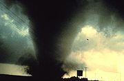
Tornadoes and Hurricanes
The Great Plains and Midwest, due to the contrasting air masses, sees frequent severe thunderstorms and tornado outbreaks during spring and summer with around 1,000 tornadoes occurring each year. The strip of land from north TexasTexas
Texas is the second largest U.S. state by both area and population, and the largest state by area in the contiguous United States.The name, based on the Caddo word "Tejas" meaning "friends" or "allies", was applied by the Spanish to the Caddo themselves and to the region of their settlement in...
north to Kansas
Kansas
Kansas is a US state located in the Midwestern United States. It is named after the Kansas River which flows through it, which in turn was named after the Kansa Native American tribe, which inhabited the area. The tribe's name is often said to mean "people of the wind" or "people of the south...
and east into Tennessee
Tennessee
Tennessee is a U.S. state located in the Southeastern United States. It has a population of 6,346,105, making it the nation's 17th-largest state by population, and covers , making it the 36th-largest by total land area...
is known as Tornado Alley
Tornado Alley
Tornado Alley is a colloquial and popular media term that most often refers to the area of the United States where tornadoes are most frequent. Although an official location is not defined, the area between the Rocky Mountains and Appalachian Mountains is usually associated with it.The areas...
, where many houses have tornado shelters and many towns have tornado sirens. Another natural disaster that frequents the country are hurricanes, which can hit anywhere along the Gulf Coast or the Atlantic Coast
East Coast of the United States
The East Coast of the United States, also known as the Eastern Seaboard, refers to the easternmost coastal states in the United States, which touch the Atlantic Ocean and stretch up to Canada. The term includes the U.S...
as well as Hawaii in the Pacific Ocean. Particularly at risk are the central and southern Texas
Texas
Texas is the second largest U.S. state by both area and population, and the largest state by area in the contiguous United States.The name, based on the Caddo word "Tejas" meaning "friends" or "allies", was applied by the Spanish to the Caddo themselves and to the region of their settlement in...
coasts, the area from southeastern Louisiana
Louisiana
Louisiana is a state located in the southern region of the United States of America. Its capital is Baton Rouge and largest city is New Orleans. Louisiana is the only state in the U.S. with political subdivisions termed parishes, which are local governments equivalent to counties...
east to the Florida Panhandle
Florida Panhandle
The Florida Panhandle, an informal, unofficial term for the northwestern part of Florida, is a strip of land roughly 200 miles long and 50 to 100 miles wide , lying between Alabama on the north and the west, Georgia also on the north, and the Gulf of Mexico to the south. Its eastern boundary is...
, the east coast of Florida
Florida
Florida is a state in the southeastern United States, located on the nation's Atlantic and Gulf coasts. It is bordered to the west by the Gulf of Mexico, to the north by Alabama and Georgia and to the east by the Atlantic Ocean. With a population of 18,801,310 as measured by the 2010 census, it...
, and the Outer Banks
Outer Banks
The Outer Banks is a 200-mile long string of narrow barrier islands off the coast of North Carolina, beginning in the southeastern corner of Virginia Beach on the east coast of the United States....
of North Carolina
North Carolina
North Carolina is a state located in the southeastern United States. The state borders South Carolina and Georgia to the south, Tennessee to the west and Virginia to the north. North Carolina contains 100 counties. Its capital is Raleigh, and its largest city is Charlotte...
, although any portion of the coast could be struck. Hurricane season runs from June 1 to November 30, with a peak from mid-August through early October. Some of the more devastating hurricanes have included the Galveston Hurricane of 1900
Galveston Hurricane of 1900
The Hurricane of 1900 made landfall on the city of Galveston in the U.S. state of Texas, on September 8, 1900.It had estimated winds of at landfall, making it a Category 4 storm on the Saffir-Simpson Hurricane Scale...
, Hurricane Andrew
Hurricane Andrew
Hurricane Andrew was the third Category 5 hurricane to make landfall in the United States, after the Labor Day Hurricane of 1935 and Hurricane Camille in 1969. Andrew was the first named storm and only major hurricane of the otherwise inactive 1992 Atlantic hurricane season...
in 1992, and Hurricane Katrina
Hurricane Katrina
Hurricane Katrina of the 2005 Atlantic hurricane season was a powerful Atlantic hurricane. It is the costliest natural disaster, as well as one of the five deadliest hurricanes, in the history of the United States. Among recorded Atlantic hurricanes, it was the sixth strongest overall...
in 2005. The remnants of tropical cyclones from the Eastern Pacific also occasionally impact the western United States, bringing moderate to heavy rainfall.

Flooding
Occasional severe flooding is experienced. There was the Great Mississippi Flood of 1927Great Mississippi Flood of 1927
The Great Mississippi Flood of 1927 was the most destructive river flood in the history of the United States.-Events:The flood began when heavy rains pounded the central basin of the Mississippi in the summer of 1926. By September, the Mississippi's tributaries in Kansas and Iowa were swollen to...
, the Great Flood of 1993
Great Flood of 1993
The Great Mississippi and Missouri Rivers Flood of 1993 occurred in the American Midwest, along the Mississippi and Missouri rivers and their tributaries, from April to October 1993. The flood was among the most costly and devastating to ever occur in the United States, with $15 billion in damages...
, and widespread flooding and mudslides caused by the 1982-1983 El Niño
Enso
Ensō is a Japanese word meaning "circle" and a concept strongly associated with Zen. Ensō is one of the most common subjects of Japanese calligraphy even though it is a symbol and not a character. It symbolizes the Absolute enlightenment, strength, elegance, the Universe, and the void; it can...
event in the western United States. Localized flooding can, however, occur anywhere, and mudslides from heavy rain can cause problems in any mountainous area, particularly the Southwest. Large stretches of desert shrub in the west can fuel the spread of wildfire
Wildfire
A wildfire is any uncontrolled fire in combustible vegetation that occurs in the countryside or a wilderness area. Other names such as brush fire, bushfire, forest fire, desert fire, grass fire, hill fire, squirrel fire, vegetation fire, veldfire, and wilkjjofire may be used to describe the same...
s. The narrow canyons of many mountain areas in the west and severe thunderstorm activity during the monsoon
Monsoon
Monsoon is traditionally defined as a seasonal reversing wind accompanied by corresponding changes in precipitation, but is now used to describe seasonal changes in atmospheric circulation and precipitation associated with the asymmetric heating of land and sea...
season in summer leads to sometimes devastating flash flood
Flash flood
A flash flood is a rapid flooding of geomorphic low-lying areas—washes, rivers, dry lakes and basins. It may be caused by heavy rain associated with a storm, hurricane, or tropical storm or meltwater from ice or snow flowing over ice sheets or snowfields...
s as well, while Nor'Easter snowstorms can bring activity to a halt throughout the Northeast (although heavy snowstorms can occur almost anywhere).
Geologic
The West Coast of the continental United States and areas of Alaska (including the Aleutian Islands, the Alaskan Peninsula and southern Alaskan coast) make up part of the Pacific Ring of FirePacific Ring of Fire
The Pacific Ring of Fire is an area where large numbers of earthquakes and volcanic eruptions occur in the basin of the Pacific Ocean. In a horseshoe shape, it is associated with a nearly continuous series of oceanic trenches, volcanic arcs, and volcanic belts and/or plate movements...
, an area of heavy tectonic and volcanic activity that is the source of 90% of the world's earthquakes. The American Northwest sees the highest concentration of active volcanoes in the United States, in Washington, Oregon
Oregon
Oregon is a state in the Pacific Northwest region of the United States. It is located on the Pacific coast, with Washington to the north, California to the south, Nevada on the southeast and Idaho to the east. The Columbia and Snake rivers delineate much of Oregon's northern and eastern...
and northern California
Northern California
Northern California is the northern portion of the U.S. state of California. The San Francisco Bay Area , and Sacramento as well as its metropolitan area are the main population centers...
along the Cascade Mountains. There are several active volcanoes located in the islands of Hawaii, including Kilauea in ongoing eruption since 1983, but they do not typically adversely affect the inhabitants of the islands. There has not been a major life-threatening eruption on the Hawaiian islands since the 17th century. Volcanic eruptions can occasionally be devastating, such as in the 1980 eruption of Mount St. Helens
1980 eruption of Mount St. Helens
The 1980 eruption of Mount St. Helens, a stratovolcano located in Washington state, in the United States, was a major volcanic eruption. The eruption was the only significant one to occur in the contiguous 48 U.S. states since the 1915 eruption of Lassen Peak in California...
in Washington.
The Ring of Fire makes California
California
California is a state located on the West Coast of the United States. It is by far the most populous U.S. state, and the third-largest by land area...
and southern Alaska
Alaska
Alaska is the largest state in the United States by area. It is situated in the northwest extremity of the North American continent, with Canada to the east, the Arctic Ocean to the north, and the Pacific Ocean to the west and south, with Russia further west across the Bering Strait...
particularly vulnerable to earthquake
Earthquake
An earthquake is the result of a sudden release of energy in the Earth's crust that creates seismic waves. The seismicity, seismism or seismic activity of an area refers to the frequency, type and size of earthquakes experienced over a period of time...
s. Earthquakes can cause extensive damage, such as the 1906 San Francisco Earthquake
1906 San Francisco earthquake
The San Francisco earthquake of 1906 was a major earthquake that struck San Francisco, California, and the coast of Northern California at 5:12 a.m. on Wednesday, April 18, 1906. The most widely accepted estimate for the magnitude of the earthquake is a moment magnitude of 7.9; however, other...
or the 1964 Good Friday Earthquake
Good Friday Earthquake
The 1964 Alaska earthquake, also known as the Great Alaskan Earthquake, the Portage Earthquake and the Good Friday Earthquake, was a megathrust earthquake that began at 5:36 P.M. AST on Good Friday, March 27, 1964...
near Anchorage, Alaska
Anchorage, Alaska
Anchorage is a unified home rule municipality in the southcentral part of the U.S. state of Alaska. It is the northernmost major city in the United States...
. California is well known for seismic activity, and requires large structures to be earthquake resistant to minimize loss of life and property. Outside of devastating earthquakes, California experiences minor earthquakes on a regular basis.
Other Natural Disasters
Other natural disasters include: tsunamiTsunami
A tsunami is a series of water waves caused by the displacement of a large volume of a body of water, typically an ocean or a large lake...
s around Pacific Basin, mud slides in California, and forest fires in the western half of the contiguous U.S. Although drought is relatively rare, it has occasionally caused major economic and social disruption, such as during the Dust Bowl
Dust Bowl
The Dust Bowl, or the Dirty Thirties, was a period of severe dust storms causing major ecological and agricultural damage to American and Canadian prairie lands from 1930 to 1936...
(1931–1942), which resulted in widespread crop failures and duststorms, beginning in the southern Great Plains and reaching to the Atlantic Ocean.
Public lands
The United States holds many areas for the use and enjoyment of the public. These include National ParksNational park
A national park is a reserve of natural, semi-natural, or developed land that a sovereign state declares or owns. Although individual nations designate their own national parks differently A national park is a reserve of natural, semi-natural, or developed land that a sovereign state declares or...
, National Monuments, National Forests
United States National Forest
National Forest is a classification of federal lands in the United States.National Forests are largely forest and woodland areas owned by the federal government and managed by the United States Forest Service, part of the United States Department of Agriculture. Land management of these areas...
, Wilderness areas
Strict Nature Reserve/Wilderness Area
A Strict Nature Reserve or Wilderness Area , is the highest category of protected area recognised by the World Commission on Protected Areas , a body which is part of the International Union for Conservation of Nature and Natural Resources...
, and other areas. For lists of areas, see the following articles:
- List of National Parks of the United States
- List of National Natural Landmarks
- List of U.S. National Forests
- List of U.S. Wilderness Areas
- List of miscellaneous U.S. public areas
Antipodes
The antipodesAntipodes
In geography, the antipodes of any place on Earth is the point on the Earth's surface which is diametrically opposite to it. Two points that are antipodal to one another are connected by a straight line running through the centre of the Earth....
of the continental United States are in the southern Indian Ocean
Indian Ocean
The Indian Ocean is the third largest of the world's oceanic divisions, covering approximately 20% of the water on the Earth's surface. It is bounded on the north by the Indian Subcontinent and Arabian Peninsula ; on the west by eastern Africa; on the east by Indochina, the Sunda Islands, and...
, including the Kerguelen Islands
Kerguelen Islands
The Kerguelen Islands , also known as the Desolation Islands, are a group of islands in the southern Indian Ocean constituting the emerged part of the otherwise submerged Kerguelen Plateau. The islands, along with Adélie Land, the Crozet Islands and the Amsterdam and Saint Paul Islands are part of...
(antipodal to the Montana-Saskatchewan-Alberta border) and the Amsterdam
Île Amsterdam
New Amsterdam, Amsterdam Island, or Île Amsterdam is a French island in the Indian Ocean located at . It is part of the French Southern and Antarctic Lands.- History :...
and Saint-Paul
Île Saint-Paul
Île Saint-Paul is an island forming part of the French Southern and Antarctic Lands in the Indian Ocean, with an area of . It is located about southwest of the larger Île Amsterdam, and south of Réunion...
islands (antipodal to Colorado). Most of Hawaii is antipodal to Botswana
Botswana
Botswana, officially the Republic of Botswana , is a landlocked country located in Southern Africa. The citizens are referred to as "Batswana" . Formerly the British protectorate of Bechuanaland, Botswana adopted its new name after becoming independent within the Commonwealth on 30 September 1966...
, apart from Niihau, which is antipodal to Namibia
Namibia
Namibia, officially the Republic of Namibia , is a country in southern Africa whose western border is the Atlantic Ocean. It shares land borders with Angola and Zambia to the north, Botswana to the east and South Africa to the south and east. It gained independence from South Africa on 21 March...
, and Kauai, which straddles the border. American Samoa is antipodal to Niger
Niger
Niger , officially named the Republic of Niger, is a landlocked country in Western Africa, named after the Niger River. It borders Nigeria and Benin to the south, Burkina Faso and Mali to the west, Algeria and Libya to the north and Chad to the east...
, near the town of Zinder
Zinder
Zinder is the second largest city in Niger, with a population of 170,574 by 2005 was estimated to be over 200,000...
. The northern coast of Alaska is antipodal to coastal Antarctica, from mid Queen Maud Land
Queen Maud Land
Queen Maud Land is a c. 2.7 million-square-kilometre region of Antarctica claimed as a dependent territory by Norway. The territory lies between 20° west and 45° east, between the British Antarctic Territory to the west and the Australian Antarctic Territory to the east. The latitudinal...
to Enderby Land
Enderby Land
Enderby Land is a projecting land mass of Antarctica, extending from Shinnan Glacier at to William Scoresby Bay at .Enderby Land was discovered in February 1831 by John Biscoe in the whaling brig Tula, and named after the Enderby Brothers of London, owners of the Tula, who encouraged their...
.
See also
- County (United States)County (United States)In the United States, a county is a geographic subdivision of a state , usually assigned some governmental authority. The term "county" is used in 48 of the 50 states; Louisiana is divided into parishes and Alaska into boroughs. Parishes and boroughs are called "county-equivalents" by the U.S...
- East Coast of the United StatesEast Coast of the United StatesThe East Coast of the United States, also known as the Eastern Seaboard, refers to the easternmost coastal states in the United States, which touch the Atlantic Ocean and stretch up to Canada. The term includes the U.S...
- Extreme points of the United StatesExtreme points of the United StatesThis is a list of the extreme points of the United States, the points that are farther north, south, east, or west than any other location in the country. Also included are extreme points in elevation, extreme distances, and other points of peculiar geographic interest.-Northernmost:*Point Barrow,...
- Fjords of the United StatesFjords of the United StatesThe fjords of the United States exist mainly in the states of Washington and Alaska. These fjords — long and narrow inlets in valleys carved by glacial activity — can have two or more basins separated by sills...
- Geographic centers of the United StatesGeographic centers of the United StatesThis is a list of geographic centers of each U.S. state. Note that the geographical center of the entire U.S. is northeast of Belle Fourche in Butte County, South Dakota , while that of the contiguous 48 is near Lebanon in Smith County, Kansas...
- Geography of Puerto RicoGeography of Puerto RicoThe geography of Puerto Rico describes an archipelago located between the Caribbean Sea and the North Atlantic Ocean, east of the Dominican Republic and west of the Virgin Islands. The main island of Puerto Rico is the smallest and most eastern of the Greater Antilles. With an area of , it is the...
- Geography of the Interior United StatesGeography of the Interior United StatesFor purposes of description, the physical geography of the United States is split into several major physiographic divisions, three of which being the Laurentian Highlands, Interior Highlands and the Interior Plains lie in the interior of the U.S...
- Historic regions of the United StatesHistoric regions of the United StatesThis is a list of historic regions of the United States.-Colonial era :-The Thirteen Colonies:* Connecticut Colony* Delaware Colony* Province of Georgia* Province of Maryland...
- List of islands of the United States
- List of landforms of the United States
- List of mountains of the United States
- List of North American deserts
- List of regions of the United States
- List of U.S. government designations for places
- Mountain peaks of the United StatesMountain peaks of the United StatesThis article comprises three sortable tables of the major mountain peaks of the United States of America.Topographic elevation is the vertical distance above the reference geoid, a precise mathematical model of the Earth's sea level as an equipotential gravitational surface...
- Public Land Survey SystemPublic Land Survey SystemThe Public Land Survey System is a method used in the United States to survey and identify land parcels, particularly for titles and deeds of rural, wild or undeveloped land. Its basic units of area are the township and section. It is sometimes referred to as the rectangular survey system,...
- Territorial evolution of the United StatesTerritorial evolution of the United StatesThis is a list of the evolution of the borders of the United States. This lists each change to the internal and external borders of the country, as well as status and name changes. It also shows the surrounding areas that eventually became part of the United States...
- USSR–USA Maritime Boundary Agreement
- West Coast of the United StatesWest Coast of the United StatesWest Coast or Pacific Coast are terms for the westernmost coastal states of the United States. The term most often refers to the states of California, Oregon, and Washington. Although not part of the contiguous United States, Alaska and Hawaii do border the Pacific Ocean but can't be included in...
Further reading
- Brown, Ralph Hall, Historical Geography of the United States, New York : Harcourt, Brace, 1948
- Stein, Mark, How the States Got Their Shapes, New York : Smithsonian Books/Collins, 2008. ISBN 9780061431388
External links
- USGS: Tapestry of Time and Terrain
- United States Geological Survey - Maintains free aerial maps
- National Atlas of the United States of America