
Geography of the Soviet Union
Encyclopedia
The Soviet Union
was located in the middle and northern latitudes of the Northern Hemisphere
. Nearly 2.5 times larger than the landmass of the United States
, it was a continental-sized country only slightly smaller than the whole of North America, though its population density, at 13 people per square kilometer was just two-thirds that of South America
at 20, and only a little more than the 12.8 of Saudi Arabia. As opposed to any contemporary G7 industrial nations, the Soviet Union's geographical position and climate were largely arctic. Its geographical center of landmass is north of all countries other than Canada
, Iceland
and the Scandinavian countries
. 75% of the country was north of the 50th parallel
that marks the central and western border between the US and Canada; it was, on the whole, much closer to the North Pole
than to the equator.
The country's 22.4 million square kilometers included one-sixth of the Earth's land surface.
Its western portion, more than half of all Europe, made up just 25 percent of the Soviet Union; this, however, was where the overwhelming majority (about 72 percent) of the people lived and where most industrial and agricultural activities are concentrated. It was here, roughly between the Dnepr River and the Ural Mountains
, that the Russian Empire
took shape and gradually over centuries expanded to the Pacific Ocean
and into Central Asia.
Soviet borders were the longest of any nation and extended 37,000 miles (62,710 kilometers). The Soviet Union measured some 10,000 kilometers from Kaliningrad
on the Gdansk Bay
in the west to Ratmanova Island (Big Diomede Island) in the Bering Strait
, or roughly equivalent to the distance from Edinburgh
, Scotland, west to Nome, Alaska
. From the tip of the Taymyr
Peninsula on the Arctic Ocean to the Central Asian town of Kushka
near the Afghan
border extended almost 5,000 kilometers of mostly rugged, inhospitable terrain. The east-west expanse of the continental United States would easily fit between the northern and southern borders of the Soviet Union at their extremities.
Along the nearly 20,000-kilometer-long land frontier, the Soviet Union abutted twelve countries, six on each continent. In Asia, its neighbors were the Democratic People's Republic of Korea (North Korea), China
, Mongolia
, Afghanistan
, Iran
, and Turkey
; in Europe, it bordered Romania
, Hungary
, Czechoslovakia
, Poland
, Norway
, and Finland
. Except for the icy eighty-six kilometers of the Bering Strait, it would have a thirteenth neighbor: the United States. Had the Russian Empire
not sold on March 30, 1867, for approximately $360 million in 2008 dollars, the territory that in 1959 became the state of Alaska, their thirteenth neighbor would have been Canada.
A dozen seas, part of the water systems of three ocean
s—the Arctic
, Atlantic
, and Pacific
—washed Soviet shores. More than two thirds of the borders were seacoast, the world's longest coastal boundary; more than two-thirds of the coast was well above the Arctic Circle
. With the important exception of Murmansk
, which received the warm currents of the Gulf Stream
, all the coast north of the Arctic Circle was locked in ice, frozen for up to ten months each year. Access to the world's oceans was both difficult and expensive.
Any geographic description of the Soviet Union is replete with superlatives. Its inventory of land and water contained Europe
's highest mountain and longest river, the world's largest and deepest lakes, the world's lowest basins, purest waters and saltiest seas, broadest tablelands, driest deserts and wettest swamps, most expansive grassland plains and most extensive forests. Desert
scenes from Soviet Central Asia
resembled the Australian outback. The Crimean coast on the Black Sea
was the Soviet Riviera, and the mountains rimming the southern boundary were as imposing as the Swiss Alps
.
zone; the taiga
or forest zone; the steppe or plains zone; the arid zone; and the mountain
zone. Most of the Soviet Union consisted of three plains (East European Plain, West Siberian Plain
, and Turan Lowland), two plateaus (Central Siberian Plateau
and Kazakh Upland), and a series of mountainous areas, concentrated for the most part in the extreme northeast or extending intermittently along the southern border. The West Siberian Plain, the world's largest, extended east from the Urals to the Yenisey River. Because the terrain and vegetation were uniform in each of the natural zones, the Soviet Union, as a whole, presented an illusion of uniformity.
Nevertheless, the Soviet territory contained all the major vegetation zones with the exception of tropical rain forest. Ten percent of Soviet territory is tundra, that is, a treeless marshy plain. The tundra was the Soviet Union's northernmost zone of snow and ice, stretching from the Finnish border in the west to the Bering Strait in the east and then running south along the Pacific coast to the earthquake and volcanic region of northern Kamchatka Peninsula
. It was the land made famous by herds of wild reindeer, by "white nights" (dusk at midnight, dawn shortly thereafter) in summer, and by days of total darkness in winter. The long harsh winters and lack of sunshine allowed only mosses, lichens, and dwarf willows and shrubs to sprout low above the barren permafrost. Although the great Siberian rivers slowly traversed this zone in reaching the Arctic Ocean, drainage of the numerous lakes, ponds, and swamps was hampered by partial and intermittent thawing. Frost weathering is the most important physical process here, shaping a landscape modified by extensive glaciation in the last ice age
.
The northern forests of spruce
, fir
, pine
, and larch
, collectively known as the taiga
, made up the largest natural zone of the Soviet Union, an area about the size of the United States. Here too the winter is long and severe, as witnessed by the routine registering of the world's coldest temperatures for inhabited areas in the northeastern portion of this belt. The taiga zone extended in a broad band across the middle latitudes, stretching from the Finnish border in the west to the Verkhoyansk Range
in northeastern Siberia and as far south as the southern shores of Lake Baykal. Isolated sections of taiga are found along mountain ranges, as in the southern part of the Urals, and in the Amur River Valley in the Far East. About 33 percent of the population lives in this zone, which, with the mixed forest zone, includeed most of the European part of the Soviet Union and the ancestral lands of the earliest Slavic
settlers.
Long associated with traditional images of Russian landscape and cossacks on horseback are the steppes, which are treeless, grassy plains. Although they covered only 15 percent of Soviet territory, the steppes were home to roughly 44 percent of the population. They extend for 4,000 kilometers from the Carpathian Mountains
in the western Ukrainian Republic
across most of the northern portion of the Kazakh Republic
in Soviet Central Asia, between the taiga and arid zones, occupying a relatively narrow band of plains whose chernozem soils are some of the most fertile on earth. In a country of extremes, the steppe zone, with its moderate temperatures and normally adequate levels of sunshine and moisture, provides the most favorable conditions for human settlement and agriculture. Even here, however, agricultural yields were sometimes adversely affected by unpredictable levels of precipitation and occasional catastrophic droughts.
Below the steppes, and merging at times with them, was the arid zone: the semideserts and deserts of Soviet Central Asia and, particularly, of the Kazakh Republic. Portions of this zone became cotton- and rice-producing regions through intensive irrigation. For various reasons, including sparse settlement and a comparatively mild climate, the arid zone became the most prominent center for Soviet space exploration.
 One-quarter of the Soviet Union consisted of mountains or mountainous terrain. With the significant exceptions of the Ural Mountains and the mountains of eastern Siberia, the mountains occupy the southern periphery of the Soviet Union. The Urals, because they have traditionally been considered the natural boundary between Europe and Asia and because they are valuable sources of minerals, were the most famous of the country's nine major ranges. In terms of elevation (comparable to the Appalachians) and vegetation, however, they are far from impressive, and they do not serve as a formidable natural barrier.
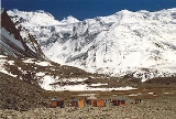
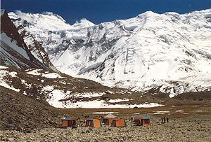
Truly alpine terrain was found in the southern mountain ranges. Between the Black and Caspian seas, for example, the Caucasus Mountains
rose to impressive heights, marking a continuation of the boundary separating Europe from Asia. One of the peaks, Mount Elbrus
, is the highest point in Europe at 5,642 meters. This range, extending to the northwest as the Crimean and Carpathian mountains and to the southeast as the Tien Shan and Pamirs, formed an imposing natural barrier between the Soviet Union and its neighbors to the south. The highest point in the Soviet Union, at 7,495 meters, was Mount Communism (Pik Kommunizma) in the Pamirs near the border with Afghanistan, Pakistan, and China. The Pamirs and the Tien Shan were offshoots of the tallest mountain chain in the world, the Himalayas
. Eastern Siberia and the Soviet Far East are also mountainous regions, especially the volcanic peaks of the long Kamchatka Peninsula, which jutted down into the Sea of Okhotsk
. The Soviet Far East, the southern portion of Soviet Central Asia, and the Caucasus were the Soviet Union's centers of seismic activity. In 1887, for example, a severe earthquake destroyed the city of Verny
(present-day Almaty), and in December 1988 a massive quake demolished the Armenian city of Spitak
and large sections of Kirovakan and Leninakan. The 1988 quake, one of the worst in Soviet history, claimed more than 25,000 lives.
The Soviet Union's water resources were both scarce and abundant. With about 3 million rivers and approximately 4 million inland bodies of water, the Soviet Union held the largest fresh, surface-water resources of any country. Unfortunately, most of these resources (84 percent), as with so much of the Soviet resource base, were at a great distance from consumers; they flowed through sparsely populated territory and into the Arctic and Pacific oceans. In contrast, areas with the highest concentrations of population, and therefore the highest demand for water supplies, tended to have the warmest climates and highest rates of evaporation. The result is barely adequate (or in some cases inadequate) water resources where they are needed most.
Nonetheless, as in many other countries, the earliest settlements sprang up on the rivers, and that is where the majority of the urban population prefers to live. The Volga, Europe's longest river, was by far the Soviet Union's most important commercial waterway. Three of the country's twenty-three cities with more than one million inhabitants were located on its banks: Gorky
, Kazan
, and Kuybyshev
.
The European part of the Soviet Union had extensive, highly developed, and heavily used water resources, among them the key hydrosystems of the Volga, Kama, Dnepr, Dnestr, and Don rivers. As is the case with fuels, however, the greatest water resources are found east of the Urals, deep in Siberia. Of the sixty-three rivers in the Soviet Union longer than 1,000 kilometers, forty are east of the Urals, including the four mighty rivers that drain Siberia as they flow northward to the Arctic Ocean: the Irtysh
, Ob', Yenisey, and Lena
rivers. The Amur River formed part of the winding and sometimes tense boundary between the Soviet Union and People's Republic of China
. Taming and exploiting the hydroelectric potential of these systems has been a monumental and highly publicized national project. Some of the world's largest hydroelectric stations operated on these rivers. Hundreds of smaller hydroelectric power plants and associated reservoirs were also constructed on the rivers. Thousands of kilometers of canals linked river and lake systems and provide essential sources of irrigation for farmland.
The Soviet Union's four million inland bodies of water were chiefly a legacy of extensive glaciation. Most prominent among them are the Caspian Sea
, the world's largest inland sea, and Lake Baikal
, the world's deepest and most capacious freshwater lake. Lake Baikal alone held 85 percent of the freshwater resources of the lakes in the Soviet Union and 20 percent of the world's total. Other water resources included swampland, a sizable portion of territory (10 percent), and glaciers in the northern areas.
s perfectly preserved, locked in ice for several thousand years. Millions of square kilometers experience half a year of subfreezing temperatures and snow covered over subsoil that was permanently frozen in places to depths of several hundred meters. In northeastern Siberia, not far from Yakutsk
, hardy settlers coped with January temperatures that consistently average -50 °C. Transportation routes, including entire railroad lines, had been redirected in winter to traverse rock-solid waterways and lakes.
Howling Arctic winds that produced coastal wind chills as low as -152 °C and the burany, or blinding snowstorms of the steppe, were climatic manifestations of the USSR's close proximity to the North Pole and remoteness from oceans that tended to moderate the climate. A combination of the "Siberian high": cold, high-pressure systems in the east, together with wet, cold cyclonic systems in the west largely determined the overall weather patterns.
The long, cold winter had a profound impact on almost every aspect of life in the Soviet Union. It affected where and how long people live and work and what kinds of crops are grown and where they are grown (no part of the country has a year-round growing season). The length and severity of the winter, along with the sharp fluctuations in the mean summer and winter temperatures, imposed special requirements on many branches of the economy: in regions of permafrost, buildings must be constructed on pilings, and machinery must be made of specially tempered steel
; transportation systems must be engineered to perform reliably in extremely low and high temperatures; the health care field and the textile industry are greatly affected by the ramifications of six to eight months of winter; and energy demands are multiplied by extended periods of darkness and cold.
Despite its well-deserved reputation as a generally snowy, icy northern country, the Soviet Union included other major climatic zones as well. According to Soviet geographers, most of their country is located in the temperate zone, which for them included all of the European portion except the southern part of Crimea
and the Caucasus
, all of Siberia, the Soviet Far East, and the plains of Soviet Central Asia
and the southern Kazakh Republic.
Two areas outside the temperate zone demonstrated the climatic diversity of the Soviet Union: the Soviet Far East, under the influence of the Pacific Ocean, with a monsoonal climate; and the subtropical band of territory extending along the southern coast of the Soviet Union's most popular resort area, Crimea
, through the Caucasus and into Soviet Central Asia, where there were deserts and oases.
With most of the land so far removed from the oceans and the moisture they provide, levels of precipitation in the Soviet Union was low to moderate. More than half the country received fewer than forty centimeters of rainfall each year, and most of Soviet Central Asia and northeastern Siberia could count on barely one-half that amount. The wettest parts were found in the small, lush subtropical region of the Caucasus and in the Soviet Far East along the Pacific coast.
and Alaska
and Canada
are unmistakable.
Only 11 percent of the USSR's land was arable. 16 percent was meadows and pasture. 41 percent was forest and woodland. Of the remaining, much is permafrost
, or tundra. However, the Soviet Union was richly endowed with almost every major category of natural resource. Drawing upon its vast holdings, it became the world leader in the production of oil
, iron ore, manganese
, and asbestos
; it had the world's largest proven reserves of natural gas
as well as coal, iron ore, timber, gold, manganese, lead, zinc, nickel, mercury, potash, phosphates, and most strategic minerals.
Self-sufficiency had traditionally been a powerful stimulus for exploring and developing the country's huge, yet widely dispersed, resource base. It remained a source of national pride that the Soviet Union, alone among the industrialized countries of the world, could claim the ability to satisfy almost all the requirements of its economy using its own natural resources. The abundance of fossil fuels supplied not just the Soviet Union's domestic needs. For many years, an ample surplus was exported to consumers in Eastern Europe
and Western Europe
, where it earned most of the Soviet Union's convertible currency.
Although its historical, political, economic, and cultural ties bound it firmly to Europe
, the Soviet Union was, with the inclusion of Siberia
, also an Asian country. In the post-World War II
period, Siberia became known as a new frontier because of its treasure of natural resources. As resource stocks were depleted in the heavily populated European section, tapping the less accessible but vital riches east of the Urals became a national priority. The best example of this process is fuel
s and energy
. The depletion of readily accessible fuel resources west of the Urals caused development and exploitation to shift to the inhospitable terrain of western Siberia, which in the 1970s and 1980s displaced the Volga-Ural and the southern European regions as the country's primary supplier of fuel and energy. Fierce cold, permafrost
, and persistent flooding made this exploitation costly and difficult.
 The Soviet Union transformed, often radically, the country's physical environment
. In the 1970s and 1980s, Soviet citizens, from the highest officials to ordinary factory workers and farmers, began to examine negative aspects of this transformation and to call for more prudent use of natural resource
s and greater concern for environmental protection.
In spite of a series of environmental law
s and regulations passed in the 1970s, authentic environmental protection in the Soviet Union did not become a major concern until General Secretary Mikhail Gorbachev
came to power in March 1985. Without an established regulatory agency and an environmental protection infrastructure, enforcement of existing laws was largely ignored. Only occasional and isolated references appeared on such issues as air and water pollution, soil erosion, and wasteful use of natural resources in the 1970s. There were various reasons for not implementing environmental safeguards. In cases where land and industry were state owned and managed, when air and water were polluted, the state was most often the agent of this pollution. Second, and this was true especially under Joseph Stalin
's leadership, the resource base of the country was viewed as limitless and free. Third, in the Cold War
rush to modernize and to develop heavy industry, concern for damage to the environment and related damage to the health of Soviet citizens would have been viewed as detrimental to progress. Fourth, advanced means of pollution control and environmental protection can be an expensive, high-technology industry, and even in the mid-1980s many of the Soviet Union's systems to control harmful emissions were inoperable or of foreign manufacture.
Awareness of the problem must needs precede the implementation of solutions, however. Environmentalist
s such as the US' John Muir
were the chief agents of bringing environmental concerns to the attention of the public, whereupon they became political concerns; such leaders were not given a voice in the USSR, they did not step forward, or they did not exist. Most certainly they did not exist in 1867, when Muir first began distributing his writing in the US. His efforts to promote environmentalism began 50 years before the start of the Bolshevik Revolution in late 1917 and the ensuing Russian Civil War
(1918–21), known collectively as the Russian Revolution. The Soviet Union had not begun to exist until then.
Under Gorbachev
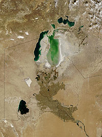
's leadership, the official attitude toward the environment changed. Various social and economic factors helped produce this change. To maintain economic growth through the 1980s, a period in which the labor force had been declining significantly, intensive and more prudent use of both natural and human resources was required. At the same time, glasnost' provided an outlet for widespread discussion of environmental issues, and a genuine grass-roots ecological movement arose to champion causes similar to the ecological concerns of the West. Public campaigns were mounted to protect Lake Baykal from industrial pollution and to halt the precipitous decline in the water levels of the Caspian Sea, the Sea of Azov, and, most urgently, the Aral Sea. A grandiose scheme to divert the northern rivers southward had been counted on to replenish these seas, but for both economic and environmental reasons, the project was canceled in 1986.
Without this diversion project, the Aral Sea
, once a body of water larger than any of the Great Lakes
except Lake Superior
, seemed destined to become the world's largest salt flat as early as the year 2010. By 1987 so much water had been siphoned off for irrigation of cotton and rice fields south and east of the sea that all shipping and commercial fishing had ceased. Former seaports, active as late as 1973, were reported to be forty to sixty kilometers from the water's edge. Belatedly recognizing the gravity of the situation for the 3 million inhabitants of the Aral region, government officials declared it an ecological disaster area.
With respect to air pollution
, mass demonstrations protesting unhealthful conditions were held in cities such as Yerevan
in the Armenian SSR
. Official reports confirmed that more than 100 of the largest Soviet cities registered air quality indexes ten times worse than permissible levels. In one of the most publicized cases, the inhabitants of Kirishi, a city not far from Leningrad, succeeded in closing a chemical plant whose toxic emissions were found to be harming—and in some cases killing—the city's residents. Finally, separate, highly publicized cases of man-made disasters, the most prominent of which was the Chernobyl' nuclear power plant accident in 1986, highlighted the fragility of the manproduction -nature relationship in the Soviet Union and forced a reconsideration of traditional attitudes and policies toward industrialization and development.
As part of the process of restructuring (perestroika
), in the 1980s concrete steps were taken to strengthen environmental protection and to provide the country with an effective mechanism for implementing policy and ensuring compliance. Two specific indications of this were the inclusion of a new section devoted to environmental protection in the annual statistical yearbook and the establishment of the State Committee for the Protection of Nature (Gosudarstvennyi komitet po okhrane prirody—Goskompriroda) early in 1988.
Despite these measures, decades of environmental degradation caused by severe air and water pollution
and land abuse were unlikely to be remedied soon or easily. Solving these critical problems will require not only a major redirection of capital and labor but also a fundamental change in the entire Soviet approach to industrial and agricultural production and resource exploitation and consumption.
.
Location: Occupied eastern portion of Europe
an continent and northern portion of Asia
n continent. Most of country north of 50° north latitude.
Topography: Vast steppe
with low hills west of Ural Mountains
; extensive coniferous forest and tundra in Siberia
; deserts in Central Asia
; mountains along southern boundaries.
Climate: Generally temperate
to Arctic
continental. Winters varied from short and cold along Black Sea
to long and frigid in Siberia
. Summers varied from hot in southern deserts to cool along Arctic coast. Weather usually harsh and unpredictable. Generally dry with more than half of country receiving fewer than forty centimeters of rainfall per year, most of Soviet Central Asia northeastern Siberia receiving only half that amount.
Water Boundaries: 42,777 kilometers washed by oceanic systems of Arctic, Atlantic, and Pacific.
Land Use: 11 percent of land arable; 16 percent meadows and pasture; 41 percent forest and woodland; and 32 percent other, including tundra.
Natural Resources: Oil, natural gas, coal, iron ore, timber, gold, manganese, lead, zinc, nickel, mercury, potash, phosphates, and most strategic minerals.
Above section:.
Soviet Union
The Soviet Union , officially the Union of Soviet Socialist Republics , was a constitutionally socialist state that existed in Eurasia between 1922 and 1991....
was located in the middle and northern latitudes of the Northern Hemisphere
Northern Hemisphere
The Northern Hemisphere is the half of a planet that is north of its equator—the word hemisphere literally means “half sphere”. It is also that half of the celestial sphere north of the celestial equator...
. Nearly 2.5 times larger than the landmass of the United States
United States
The United States of America is a federal constitutional republic comprising fifty states and a federal district...
, it was a continental-sized country only slightly smaller than the whole of North America, though its population density, at 13 people per square kilometer was just two-thirds that of South America
South America
South America is a continent situated in the Western Hemisphere, mostly in the Southern Hemisphere, with a relatively small portion in the Northern Hemisphere. The continent is also considered a subcontinent of the Americas. It is bordered on the west by the Pacific Ocean and on the north and east...
at 20, and only a little more than the 12.8 of Saudi Arabia. As opposed to any contemporary G7 industrial nations, the Soviet Union's geographical position and climate were largely arctic. Its geographical center of landmass is north of all countries other than Canada
Canada
Canada is a North American country consisting of ten provinces and three territories. Located in the northern part of the continent, it extends from the Atlantic Ocean in the east to the Pacific Ocean in the west, and northward into the Arctic Ocean...
, Iceland
Iceland
Iceland , described as the Republic of Iceland, is a Nordic and European island country in the North Atlantic Ocean, on the Mid-Atlantic Ridge. Iceland also refers to the main island of the country, which contains almost all the population and almost all the land area. The country has a population...
and the Scandinavian countries
Scandinavia
Scandinavia is a cultural, historical and ethno-linguistic region in northern Europe that includes the three kingdoms of Denmark, Norway and Sweden, characterized by their common ethno-cultural heritage and language. Modern Norway and Sweden proper are situated on the Scandinavian Peninsula,...
. 75% of the country was north of the 50th parallel
50th parallel north
The 50th parallel north is a circle of latitude that is 50 degrees north of the Earth's equatorial plane. It crosses Europe, Asia, the Pacific Ocean, North America, and the Atlantic Ocean....
that marks the central and western border between the US and Canada; it was, on the whole, much closer to the North Pole
North Pole
The North Pole, also known as the Geographic North Pole or Terrestrial North Pole, is, subject to the caveats explained below, defined as the point in the northern hemisphere where the Earth's axis of rotation meets its surface...
than to the equator.
The country's 22.4 million square kilometers included one-sixth of the Earth's land surface.
Its western portion, more than half of all Europe, made up just 25 percent of the Soviet Union; this, however, was where the overwhelming majority (about 72 percent) of the people lived and where most industrial and agricultural activities are concentrated. It was here, roughly between the Dnepr River and the Ural Mountains
Ural Mountains
The Ural Mountains , or simply the Urals, are a mountain range that runs approximately from north to south through western Russia, from the coast of the Arctic Ocean to the Ural River and northwestern Kazakhstan. Their eastern side is usually considered the natural boundary between Europe and Asia...
, that the Russian Empire
Russian Empire
The Russian Empire was a state that existed from 1721 until the Russian Revolution of 1917. It was the successor to the Tsardom of Russia and the predecessor of the Soviet Union...
took shape and gradually over centuries expanded to the Pacific Ocean
Pacific Ocean
The Pacific Ocean is the largest of the Earth's oceanic divisions. It extends from the Arctic in the north to the Southern Ocean in the south, bounded by Asia and Australia in the west, and the Americas in the east.At 165.2 million square kilometres in area, this largest division of the World...
and into Central Asia.
Soviet borders were the longest of any nation and extended 37,000 miles (62,710 kilometers). The Soviet Union measured some 10,000 kilometers from Kaliningrad
Kaliningrad
Kaliningrad is a seaport and the administrative center of Kaliningrad Oblast, the Russian exclave between Poland and Lithuania on the Baltic Sea...
on the Gdansk Bay
Gdansk Bay
Gdańsk Bay or the Bay of Gdańsk or Danzig Bay is a southeastern bay of the Baltic Sea. It is named after the adjacent port city of Gdańsk in Poland and is sometimes referred to as a gulf.-Geography:...
in the west to Ratmanova Island (Big Diomede Island) in the Bering Strait
Bering Strait
The Bering Strait , known to natives as Imakpik, is a sea strait between Cape Dezhnev, Chukotka Autonomous Okrug, Russia, the easternmost point of the Asian continent and Cape Prince of Wales, Alaska, USA, the westernmost point of the North American continent, with latitude of about 65°40'N,...
, or roughly equivalent to the distance from Edinburgh
Edinburgh
Edinburgh is the capital city of Scotland, the second largest city in Scotland, and the eighth most populous in the United Kingdom. The City of Edinburgh Council governs one of Scotland's 32 local government council areas. The council area includes urban Edinburgh and a rural area...
, Scotland, west to Nome, Alaska
Nome, Alaska
Nome is a city in the Nome Census Area in the Unorganized Borough of the U.S. state of Alaska, located on the southern Seward Peninsula coast on Norton Sound of the Bering Sea. According to the 2010 Census, the city population was 3,598. Nome was incorporated on April 9, 1901, and was once the...
. From the tip of the Taymyr
Taymyr
Taimyr or Taymyr may refer to:*Taymyr Peninsula, a peninsula in Siberia*Taymyr Autonomous Okrug, a former federal subject of Russia*Taymyr Gulf*Taymyr River*Lake Taymyr*Taymyr Island, an island in the Kara Sea...
Peninsula on the Arctic Ocean to the Central Asian town of Kushka
Serhetabat
Serhetabat is a small town in the Mary Province in Turkmenistan, located in the valley of the Kushka River. Population: 5,200 ....
near the Afghan
Afghanistan
Afghanistan , officially the Islamic Republic of Afghanistan, is a landlocked country located in the centre of Asia, forming South Asia, Central Asia and the Middle East. With a population of about 29 million, it has an area of , making it the 42nd most populous and 41st largest nation in the world...
border extended almost 5,000 kilometers of mostly rugged, inhospitable terrain. The east-west expanse of the continental United States would easily fit between the northern and southern borders of the Soviet Union at their extremities.
Along the nearly 20,000-kilometer-long land frontier, the Soviet Union abutted twelve countries, six on each continent. In Asia, its neighbors were the Democratic People's Republic of Korea (North Korea), China
China
Chinese civilization may refer to:* China for more general discussion of the country.* Chinese culture* Greater China, the transnational community of ethnic Chinese.* History of China* Sinosphere, the area historically affected by Chinese culture...
, Mongolia
Mongolia
Mongolia is a landlocked country in East and Central Asia. It is bordered by Russia to the north and China to the south, east and west. Although Mongolia does not share a border with Kazakhstan, its western-most point is only from Kazakhstan's eastern tip. Ulan Bator, the capital and largest...
, Afghanistan
Afghanistan
Afghanistan , officially the Islamic Republic of Afghanistan, is a landlocked country located in the centre of Asia, forming South Asia, Central Asia and the Middle East. With a population of about 29 million, it has an area of , making it the 42nd most populous and 41st largest nation in the world...
, Iran
Iran
Iran , officially the Islamic Republic of Iran , is a country in Southern and Western Asia. The name "Iran" has been in use natively since the Sassanian era and came into use internationally in 1935, before which the country was known to the Western world as Persia...
, and Turkey
Turkey
Turkey , known officially as the Republic of Turkey , is a Eurasian country located in Western Asia and in East Thrace in Southeastern Europe...
; in Europe, it bordered Romania
Romania
Romania is a country located at the crossroads of Central and Southeastern Europe, on the Lower Danube, within and outside the Carpathian arch, bordering on the Black Sea...
, Hungary
Hungary
Hungary , officially the Republic of Hungary , is a landlocked country in Central Europe. It is situated in the Carpathian Basin and is bordered by Slovakia to the north, Ukraine and Romania to the east, Serbia and Croatia to the south, Slovenia to the southwest and Austria to the west. The...
, Czechoslovakia
Czechoslovakia
Czechoslovakia or Czecho-Slovakia was a sovereign state in Central Europe which existed from October 1918, when it declared its independence from the Austro-Hungarian Empire, until 1992...
, Poland
Poland
Poland , officially the Republic of Poland , is a country in Central Europe bordered by Germany to the west; the Czech Republic and Slovakia to the south; Ukraine, Belarus and Lithuania to the east; and the Baltic Sea and Kaliningrad Oblast, a Russian exclave, to the north...
, Norway
Norway
Norway , officially the Kingdom of Norway, is a Nordic unitary constitutional monarchy whose territory comprises the western portion of the Scandinavian Peninsula, Jan Mayen, and the Arctic archipelago of Svalbard and Bouvet Island. Norway has a total area of and a population of about 4.9 million...
, and Finland
Finland
Finland , officially the Republic of Finland, is a Nordic country situated in the Fennoscandian region of Northern Europe. It is bordered by Sweden in the west, Norway in the north and Russia in the east, while Estonia lies to its south across the Gulf of Finland.Around 5.4 million people reside...
. Except for the icy eighty-six kilometers of the Bering Strait, it would have a thirteenth neighbor: the United States. Had the Russian Empire
Russian Empire
The Russian Empire was a state that existed from 1721 until the Russian Revolution of 1917. It was the successor to the Tsardom of Russia and the predecessor of the Soviet Union...
not sold on March 30, 1867, for approximately $360 million in 2008 dollars, the territory that in 1959 became the state of Alaska, their thirteenth neighbor would have been Canada.
A dozen seas, part of the water systems of three ocean
Ocean
An ocean is a major body of saline water, and a principal component of the hydrosphere. Approximately 71% of the Earth's surface is covered by ocean, a continuous body of water that is customarily divided into several principal oceans and smaller seas.More than half of this area is over 3,000...
s—the Arctic
Arctic Ocean
The Arctic Ocean, located in the Northern Hemisphere and mostly in the Arctic north polar region, is the smallest and shallowest of the world's five major oceanic divisions...
, Atlantic
Atlantic Ocean
The Atlantic Ocean is the second-largest of the world's oceanic divisions. With a total area of about , it covers approximately 20% of the Earth's surface and about 26% of its water surface area...
, and Pacific
Pacific Ocean
The Pacific Ocean is the largest of the Earth's oceanic divisions. It extends from the Arctic in the north to the Southern Ocean in the south, bounded by Asia and Australia in the west, and the Americas in the east.At 165.2 million square kilometres in area, this largest division of the World...
—washed Soviet shores. More than two thirds of the borders were seacoast, the world's longest coastal boundary; more than two-thirds of the coast was well above the Arctic Circle
Arctic Circle
The Arctic Circle is one of the five major circles of latitude that mark maps of the Earth. For Epoch 2011, it is the parallel of latitude that runs north of the Equator....
. With the important exception of Murmansk
Murmansk
Murmansk is a city and the administrative center of Murmansk Oblast, Russia. It serves as a seaport and is located in the extreme northwest part of Russia, on the Kola Bay, from the Barents Sea on the northern shore of the Kola Peninsula, not far from Russia's borders with Norway and Finland...
, which received the warm currents of the Gulf Stream
Gulf Stream
The Gulf Stream, together with its northern extension towards Europe, the North Atlantic Drift, is a powerful, warm, and swift Atlantic ocean current that originates at the tip of Florida, and follows the eastern coastlines of the United States and Newfoundland before crossing the Atlantic Ocean...
, all the coast north of the Arctic Circle was locked in ice, frozen for up to ten months each year. Access to the world's oceans was both difficult and expensive.
Any geographic description of the Soviet Union is replete with superlatives. Its inventory of land and water contained Europe
Europe
Europe is, by convention, one of the world's seven continents. Comprising the westernmost peninsula of Eurasia, Europe is generally 'divided' from Asia to its east by the watershed divides of the Ural and Caucasus Mountains, the Ural River, the Caspian and Black Seas, and the waterways connecting...
's highest mountain and longest river, the world's largest and deepest lakes, the world's lowest basins, purest waters and saltiest seas, broadest tablelands, driest deserts and wettest swamps, most expansive grassland plains and most extensive forests. Desert
Desert
A desert is a landscape or region that receives an extremely low amount of precipitation, less than enough to support growth of most plants. Most deserts have an average annual precipitation of less than...
scenes from Soviet Central Asia
Central Asia
Central Asia is a core region of the Asian continent from the Caspian Sea in the west, China in the east, Afghanistan in the south, and Russia in the north...
resembled the Australian outback. The Crimean coast on the Black Sea
Black Sea
The Black Sea is bounded by Europe, Anatolia and the Caucasus and is ultimately connected to the Atlantic Ocean via the Mediterranean and the Aegean seas and various straits. The Bosphorus strait connects it to the Sea of Marmara, and the strait of the Dardanelles connects that sea to the Aegean...
was the Soviet Riviera, and the mountains rimming the southern boundary were as imposing as the Swiss Alps
Swiss Alps
The Swiss Alps are the portion of the Alps mountain range that lies within Switzerland. Because of their central position within the entire Alpine range, they are also known as the Central Alps....
.
Topography and drainage
Most geographers divide the vast Soviet territory into five natural zones that generally extend from west to east: the tundraTundra
In physical geography, tundra is a biome where the tree growth is hindered by low temperatures and short growing seasons. The term tundra comes through Russian тундра from the Kildin Sami word tūndâr "uplands," "treeless mountain tract." There are three types of tundra: Arctic tundra, alpine...
zone; the taiga
Taiga
Taiga , also known as the boreal forest, is a biome characterized by coniferous forests.Taiga is the world's largest terrestrial biome. In North America it covers most of inland Canada and Alaska as well as parts of the extreme northern continental United States and is known as the Northwoods...
or forest zone; the steppe or plains zone; the arid zone; and the mountain
Mountain
Image:Himalaya_annotated.jpg|thumb|right|The Himalayan mountain range with Mount Everestrect 58 14 160 49 Chomo Lonzorect 200 28 335 52 Makalurect 378 24 566 45 Mount Everestrect 188 581 920 656 Tibetan Plateaurect 250 406 340 427 Rong River...
zone. Most of the Soviet Union consisted of three plains (East European Plain, West Siberian Plain
West Siberian Plain
The West Siberian Plain is a large plain that occupies the western portion of Siberia, between the Ural Mountains in the west and the Yenisei River in the east, and by the Altay Mountains on the South-East. Much of the plain is poorly drained and consists of some of the world's largest swamps and...
, and Turan Lowland), two plateaus (Central Siberian Plateau
Central Siberian Plateau
The Central Siberian Plateau is made up of sharply demarcated surfaces of varying altitudes occupying most of Siberia between the Yenisei and Lena rivers. It extends over an area of 3.5 million km². The highest point is the Putoran Mountains rising to 1701 m. To the north of the plateau are...
and Kazakh Upland), and a series of mountainous areas, concentrated for the most part in the extreme northeast or extending intermittently along the southern border. The West Siberian Plain, the world's largest, extended east from the Urals to the Yenisey River. Because the terrain and vegetation were uniform in each of the natural zones, the Soviet Union, as a whole, presented an illusion of uniformity.
Nevertheless, the Soviet territory contained all the major vegetation zones with the exception of tropical rain forest. Ten percent of Soviet territory is tundra, that is, a treeless marshy plain. The tundra was the Soviet Union's northernmost zone of snow and ice, stretching from the Finnish border in the west to the Bering Strait in the east and then running south along the Pacific coast to the earthquake and volcanic region of northern Kamchatka Peninsula
Kamchatka Peninsula
The Kamchatka Peninsula is a peninsula in the Russian Far East, with an area of . It lies between the Pacific Ocean to the east and the Sea of Okhotsk to the west...
. It was the land made famous by herds of wild reindeer, by "white nights" (dusk at midnight, dawn shortly thereafter) in summer, and by days of total darkness in winter. The long harsh winters and lack of sunshine allowed only mosses, lichens, and dwarf willows and shrubs to sprout low above the barren permafrost. Although the great Siberian rivers slowly traversed this zone in reaching the Arctic Ocean, drainage of the numerous lakes, ponds, and swamps was hampered by partial and intermittent thawing. Frost weathering is the most important physical process here, shaping a landscape modified by extensive glaciation in the last ice age
Ice age
An ice age or, more precisely, glacial age, is a generic geological period of long-term reduction in the temperature of the Earth's surface and atmosphere, resulting in the presence or expansion of continental ice sheets, polar ice sheets and alpine glaciers...
.
The northern forests of spruce
Spruce
A spruce is a tree of the genus Picea , a genus of about 35 species of coniferous evergreen trees in the Family Pinaceae, found in the northern temperate and boreal regions of the earth. Spruces are large trees, from tall when mature, and can be distinguished by their whorled branches and conical...
, fir
Fir
Firs are a genus of 48–55 species of evergreen conifers in the family Pinaceae. They are found through much of North and Central America, Europe, Asia, and North Africa, occurring in mountains over most of the range...
, pine
Pine
Pines are trees in the genus Pinus ,in the family Pinaceae. They make up the monotypic subfamily Pinoideae. There are about 115 species of pine, although different authorities accept between 105 and 125 species.-Etymology:...
, and larch
Larch
Larches are conifers in the genus Larix, in the family Pinaceae. Growing from 15 to 50m tall, they are native to much of the cooler temperate northern hemisphere, on lowlands in the north and high on mountains further south...
, collectively known as the taiga
Taiga
Taiga , also known as the boreal forest, is a biome characterized by coniferous forests.Taiga is the world's largest terrestrial biome. In North America it covers most of inland Canada and Alaska as well as parts of the extreme northern continental United States and is known as the Northwoods...
, made up the largest natural zone of the Soviet Union, an area about the size of the United States. Here too the winter is long and severe, as witnessed by the routine registering of the world's coldest temperatures for inhabited areas in the northeastern portion of this belt. The taiga zone extended in a broad band across the middle latitudes, stretching from the Finnish border in the west to the Verkhoyansk Range
Verkhoyansk Range
thumb|right|The Verkhoyansk Range is the L-shaped area east of the LenaThe Verkhoyansk Range is a mountain range of eastern Siberia, spanning ca. 1000 km , across the Sakha Republic. It forms a vast arc between the Lena and Aldan rivers to the west and the Yana River to the east. It rises to ca....
in northeastern Siberia and as far south as the southern shores of Lake Baykal. Isolated sections of taiga are found along mountain ranges, as in the southern part of the Urals, and in the Amur River Valley in the Far East. About 33 percent of the population lives in this zone, which, with the mixed forest zone, includeed most of the European part of the Soviet Union and the ancestral lands of the earliest Slavic
Slavic peoples
The Slavic people are an Indo-European panethnicity living in Eastern Europe, Southeast Europe, North Asia and Central Asia. The term Slavic represents a broad ethno-linguistic group of people, who speak languages belonging to the Slavic language family and share, to varying degrees, certain...
settlers.
Long associated with traditional images of Russian landscape and cossacks on horseback are the steppes, which are treeless, grassy plains. Although they covered only 15 percent of Soviet territory, the steppes were home to roughly 44 percent of the population. They extend for 4,000 kilometers from the Carpathian Mountains
Carpathian Mountains
The Carpathian Mountains or Carpathians are a range of mountains forming an arc roughly long across Central and Eastern Europe, making them the second-longest mountain range in Europe...
in the western Ukrainian Republic
Ukrainian SSR
The Ukrainian Soviet Socialist Republic or in short, the Ukrainian SSR was a sovereign Soviet Socialist state and one of the fifteen constituent republics of the Soviet Union lasting from its inception in 1922 to the breakup in 1991...
across most of the northern portion of the Kazakh Republic
Kazakh SSR
The Kazakh Soviet Socialist Republic , also known as the Kazakh SSR for short, was one of republics that made up the Soviet Union.At in area, it was the second largest constituent republic in the USSR, after the Russian SFSR. Its capital was Alma-Ata . Today it is the independent state of...
in Soviet Central Asia, between the taiga and arid zones, occupying a relatively narrow band of plains whose chernozem soils are some of the most fertile on earth. In a country of extremes, the steppe zone, with its moderate temperatures and normally adequate levels of sunshine and moisture, provides the most favorable conditions for human settlement and agriculture. Even here, however, agricultural yields were sometimes adversely affected by unpredictable levels of precipitation and occasional catastrophic droughts.
Below the steppes, and merging at times with them, was the arid zone: the semideserts and deserts of Soviet Central Asia and, particularly, of the Kazakh Republic. Portions of this zone became cotton- and rice-producing regions through intensive irrigation. For various reasons, including sparse settlement and a comparatively mild climate, the arid zone became the most prominent center for Soviet space exploration.
Truly alpine terrain was found in the southern mountain ranges. Between the Black and Caspian seas, for example, the Caucasus Mountains
Caucasus Mountains
The Caucasus Mountains is a mountain system in Eurasia between the Black Sea and the Caspian Sea in the Caucasus region .The Caucasus Mountains includes:* the Greater Caucasus Mountain Range and* the Lesser Caucasus Mountains....
rose to impressive heights, marking a continuation of the boundary separating Europe from Asia. One of the peaks, Mount Elbrus
Mount Elbrus
Mount Elbrus is an inactive volcano located in the western Caucasus mountain range, in Kabardino-Balkaria and Karachay-Cherkessia, Russia, near the border of Georgia. Mt. Elbrus's peak is the highest in the Caucasus, in Russia...
, is the highest point in Europe at 5,642 meters. This range, extending to the northwest as the Crimean and Carpathian mountains and to the southeast as the Tien Shan and Pamirs, formed an imposing natural barrier between the Soviet Union and its neighbors to the south. The highest point in the Soviet Union, at 7,495 meters, was Mount Communism (Pik Kommunizma) in the Pamirs near the border with Afghanistan, Pakistan, and China. The Pamirs and the Tien Shan were offshoots of the tallest mountain chain in the world, the Himalayas
Himalayas
The Himalaya Range or Himalaya Mountains Sanskrit: Devanagari: हिमालय, literally "abode of snow"), usually called the Himalayas or Himalaya for short, is a mountain range in Asia, separating the Indian subcontinent from the Tibetan Plateau...
. Eastern Siberia and the Soviet Far East are also mountainous regions, especially the volcanic peaks of the long Kamchatka Peninsula, which jutted down into the Sea of Okhotsk
Sea of Okhotsk
The Sea of Okhotsk is a marginal sea of the western Pacific Ocean, lying between the Kamchatka Peninsula on the east, the Kuril Islands on the southeast, the island of Hokkaidō to the far south, the island of Sakhalin along the west, and a long stretch of eastern Siberian coast along the west and...
. The Soviet Far East, the southern portion of Soviet Central Asia, and the Caucasus were the Soviet Union's centers of seismic activity. In 1887, for example, a severe earthquake destroyed the city of Verny
Verny
Verny is a commune in the Moselle department in Lorraine in north-eastern France....
(present-day Almaty), and in December 1988 a massive quake demolished the Armenian city of Spitak
Spitak
Spitak is a city in northern Armenia located in the Lori region with a population of 18,237. It was mostly destroyed by the devastating Spitak Earthquake in 1988, and was subsequently rebuilt in a slightly different location. Spitak means '"White" in Armenian....
and large sections of Kirovakan and Leninakan. The 1988 quake, one of the worst in Soviet history, claimed more than 25,000 lives.
The Soviet Union's water resources were both scarce and abundant. With about 3 million rivers and approximately 4 million inland bodies of water, the Soviet Union held the largest fresh, surface-water resources of any country. Unfortunately, most of these resources (84 percent), as with so much of the Soviet resource base, were at a great distance from consumers; they flowed through sparsely populated territory and into the Arctic and Pacific oceans. In contrast, areas with the highest concentrations of population, and therefore the highest demand for water supplies, tended to have the warmest climates and highest rates of evaporation. The result is barely adequate (or in some cases inadequate) water resources where they are needed most.
Nonetheless, as in many other countries, the earliest settlements sprang up on the rivers, and that is where the majority of the urban population prefers to live. The Volga, Europe's longest river, was by far the Soviet Union's most important commercial waterway. Three of the country's twenty-three cities with more than one million inhabitants were located on its banks: Gorky
Nizhny Novgorod
Nizhny Novgorod , colloquially shortened to Nizhny, is, with the population of 1,250,615, the fifth largest city in Russia, ranking after Moscow, St. Petersburg, Novosibirsk, and Yekaterinburg...
, Kazan
Kazan
Kazan is the capital and largest city of the Republic of Tatarstan, Russia. With a population of 1,143,546 , it is the eighth most populous city in Russia. Kazan lies at the confluence of the Volga and Kazanka Rivers in European Russia. In April 2009, the Russian Patent Office granted Kazan the...
, and Kuybyshev
Samara, Russia
Samara , is the sixth largest city in Russia. It is situated in the southeastern part of European Russia at the confluence of the Volga and Samara Rivers. Samara is the administrative center of Samara Oblast. Population: . The metropolitan area of Samara-Tolyatti-Syzran within Samara Oblast...
.
The European part of the Soviet Union had extensive, highly developed, and heavily used water resources, among them the key hydrosystems of the Volga, Kama, Dnepr, Dnestr, and Don rivers. As is the case with fuels, however, the greatest water resources are found east of the Urals, deep in Siberia. Of the sixty-three rivers in the Soviet Union longer than 1,000 kilometers, forty are east of the Urals, including the four mighty rivers that drain Siberia as they flow northward to the Arctic Ocean: the Irtysh
Irtysh
The Irtysh River is a river in Siberia and is the chief tributary of the Ob River. Its name means White River. Irtysh's main affluent is the Tobol River...
, Ob', Yenisey, and Lena
Lena River
The Lena is the easternmost of the three great Siberian rivers that flow into the Arctic Ocean . It is the 11th longest river in the world and has the 9th largest watershed...
rivers. The Amur River formed part of the winding and sometimes tense boundary between the Soviet Union and People's Republic of China
People's Republic of China
China , officially the People's Republic of China , is the most populous country in the world, with over 1.3 billion citizens. Located in East Asia, the country covers approximately 9.6 million square kilometres...
. Taming and exploiting the hydroelectric potential of these systems has been a monumental and highly publicized national project. Some of the world's largest hydroelectric stations operated on these rivers. Hundreds of smaller hydroelectric power plants and associated reservoirs were also constructed on the rivers. Thousands of kilometers of canals linked river and lake systems and provide essential sources of irrigation for farmland.
The Soviet Union's four million inland bodies of water were chiefly a legacy of extensive glaciation. Most prominent among them are the Caspian Sea
Caspian Sea
The Caspian Sea is the largest enclosed body of water on Earth by area, variously classed as the world's largest lake or a full-fledged sea. The sea has a surface area of and a volume of...
, the world's largest inland sea, and Lake Baikal
Lake Baikal
Lake Baikal is the world's oldest at 30 million years old and deepest lake with an average depth of 744.4 metres.Located in the south of the Russian region of Siberia, between Irkutsk Oblast to the northwest and the Buryat Republic to the southeast, it is the most voluminous freshwater lake in the...
, the world's deepest and most capacious freshwater lake. Lake Baikal alone held 85 percent of the freshwater resources of the lakes in the Soviet Union and 20 percent of the world's total. Other water resources included swampland, a sizable portion of territory (10 percent), and glaciers in the northern areas.
Climate
Notorious cold and long winters have, understandably, been the focus of discussions on the Soviet Union's weather and climate. From the frozen depths of Siberia came baby mammothMammoth
A mammoth is any species of the extinct genus Mammuthus. These proboscideans are members of Elephantidae, the family of elephants and mammoths, and close relatives of modern elephants. They were often equipped with long curved tusks and, in northern species, a covering of long hair...
s perfectly preserved, locked in ice for several thousand years. Millions of square kilometers experience half a year of subfreezing temperatures and snow covered over subsoil that was permanently frozen in places to depths of several hundred meters. In northeastern Siberia, not far from Yakutsk
Yakutsk
With a subarctic climate , Yakutsk is the coldest city, though not the coldest inhabited place, on Earth. Average monthly temperatures range from in July to in January. The coldest temperatures ever recorded on the planet outside Antarctica occurred in the basin of the Yana River to the northeast...
, hardy settlers coped with January temperatures that consistently average -50 °C. Transportation routes, including entire railroad lines, had been redirected in winter to traverse rock-solid waterways and lakes.
Howling Arctic winds that produced coastal wind chills as low as -152 °C and the burany, or blinding snowstorms of the steppe, were climatic manifestations of the USSR's close proximity to the North Pole and remoteness from oceans that tended to moderate the climate. A combination of the "Siberian high": cold, high-pressure systems in the east, together with wet, cold cyclonic systems in the west largely determined the overall weather patterns.
The long, cold winter had a profound impact on almost every aspect of life in the Soviet Union. It affected where and how long people live and work and what kinds of crops are grown and where they are grown (no part of the country has a year-round growing season). The length and severity of the winter, along with the sharp fluctuations in the mean summer and winter temperatures, imposed special requirements on many branches of the economy: in regions of permafrost, buildings must be constructed on pilings, and machinery must be made of specially tempered steel
Steel
Steel is an alloy that consists mostly of iron and has a carbon content between 0.2% and 2.1% by weight, depending on the grade. Carbon is the most common alloying material for iron, but various other alloying elements are used, such as manganese, chromium, vanadium, and tungsten...
; transportation systems must be engineered to perform reliably in extremely low and high temperatures; the health care field and the textile industry are greatly affected by the ramifications of six to eight months of winter; and energy demands are multiplied by extended periods of darkness and cold.
Despite its well-deserved reputation as a generally snowy, icy northern country, the Soviet Union included other major climatic zones as well. According to Soviet geographers, most of their country is located in the temperate zone, which for them included all of the European portion except the southern part of Crimea
Crimea
Crimea , or the Autonomous Republic of Crimea , is a sub-national unit, an autonomous republic, of Ukraine. It is located on the northern coast of the Black Sea, occupying a peninsula of the same name...
and the Caucasus
Caucasus
The Caucasus, also Caucas or Caucasia , is a geopolitical region at the border of Europe and Asia, and situated between the Black and the Caspian sea...
, all of Siberia, the Soviet Far East, and the plains of Soviet Central Asia
Soviet Central Asia
Soviet Central Asia refers to the section of Central Asia formerly controlled by the Soviet Union, as well as the time period of Soviet administration . In terms of area, it is nearly synonymous with Russian Turkestan, the name for the region during the Russian Empire...
and the southern Kazakh Republic.
Two areas outside the temperate zone demonstrated the climatic diversity of the Soviet Union: the Soviet Far East, under the influence of the Pacific Ocean, with a monsoonal climate; and the subtropical band of territory extending along the southern coast of the Soviet Union's most popular resort area, Crimea
Crimea
Crimea , or the Autonomous Republic of Crimea , is a sub-national unit, an autonomous republic, of Ukraine. It is located on the northern coast of the Black Sea, occupying a peninsula of the same name...
, through the Caucasus and into Soviet Central Asia, where there were deserts and oases.
With most of the land so far removed from the oceans and the moisture they provide, levels of precipitation in the Soviet Union was low to moderate. More than half the country received fewer than forty centimeters of rainfall each year, and most of Soviet Central Asia and northeastern Siberia could count on barely one-half that amount. The wettest parts were found in the small, lush subtropical region of the Caucasus and in the Soviet Far East along the Pacific coast.
Land use and natural resources
The Soviet resource base was by far the world's most extensive, ensuring self-sufficiency for its people in most resources for many years. The Soviet Union was usually first or second in the annual production of most of the world's strategic raw materials. However, most of the topography and climate resembles that of the northernmost portion of the North American continent. The northern forests and the plains to the south find their closest counterparts in the Yukon Territory and in the wide swath of land extending across most of Canada. Similarities in terrain, climate, and settlement patterns between SiberiaSiberia
Siberia is an extensive region constituting almost all of Northern Asia. Comprising the central and eastern portion of the Russian Federation, it was part of the Soviet Union from its beginning, as its predecessor states, the Tsardom of Russia and the Russian Empire, conquered it during the 16th...
and Alaska
Alaska
Alaska is the largest state in the United States by area. It is situated in the northwest extremity of the North American continent, with Canada to the east, the Arctic Ocean to the north, and the Pacific Ocean to the west and south, with Russia further west across the Bering Strait...
and Canada
Canada
Canada is a North American country consisting of ten provinces and three territories. Located in the northern part of the continent, it extends from the Atlantic Ocean in the east to the Pacific Ocean in the west, and northward into the Arctic Ocean...
are unmistakable.
Only 11 percent of the USSR's land was arable. 16 percent was meadows and pasture. 41 percent was forest and woodland. Of the remaining, much is permafrost
Permafrost
In geology, permafrost, cryotic soil or permafrost soil is soil at or below the freezing point of water for two or more years. Ice is not always present, as may be in the case of nonporous bedrock, but it frequently occurs and it may be in amounts exceeding the potential hydraulic saturation of...
, or tundra. However, the Soviet Union was richly endowed with almost every major category of natural resource. Drawing upon its vast holdings, it became the world leader in the production of oil
Petroleum
Petroleum or crude oil is a naturally occurring, flammable liquid consisting of a complex mixture of hydrocarbons of various molecular weights and other liquid organic compounds, that are found in geologic formations beneath the Earth's surface. Petroleum is recovered mostly through oil drilling...
, iron ore, manganese
Manganese
Manganese is a chemical element, designated by the symbol Mn. It has the atomic number 25. It is found as a free element in nature , and in many minerals...
, and asbestos
Asbestos
Asbestos is a set of six naturally occurring silicate minerals used commercially for their desirable physical properties. They all have in common their eponymous, asbestiform habit: long, thin fibrous crystals...
; it had the world's largest proven reserves of natural gas
Natural gas
Natural gas is a naturally occurring gas mixture consisting primarily of methane, typically with 0–20% higher hydrocarbons . It is found associated with other hydrocarbon fuel, in coal beds, as methane clathrates, and is an important fuel source and a major feedstock for fertilizers.Most natural...
as well as coal, iron ore, timber, gold, manganese, lead, zinc, nickel, mercury, potash, phosphates, and most strategic minerals.
Self-sufficiency had traditionally been a powerful stimulus for exploring and developing the country's huge, yet widely dispersed, resource base. It remained a source of national pride that the Soviet Union, alone among the industrialized countries of the world, could claim the ability to satisfy almost all the requirements of its economy using its own natural resources. The abundance of fossil fuels supplied not just the Soviet Union's domestic needs. For many years, an ample surplus was exported to consumers in Eastern Europe
Eastern Europe
Eastern Europe is the eastern part of Europe. The term has widely disparate geopolitical, geographical, cultural and socioeconomic readings, which makes it highly context-dependent and even volatile, and there are "almost as many definitions of Eastern Europe as there are scholars of the region"...
and Western Europe
Western Europe
Western Europe is a loose term for the collection of countries in the western most region of the European continents, though this definition is context-dependent and carries cultural and political connotations. One definition describes Western Europe as a geographic entity—the region lying in the...
, where it earned most of the Soviet Union's convertible currency.
Although its historical, political, economic, and cultural ties bound it firmly to Europe
Europe
Europe is, by convention, one of the world's seven continents. Comprising the westernmost peninsula of Eurasia, Europe is generally 'divided' from Asia to its east by the watershed divides of the Ural and Caucasus Mountains, the Ural River, the Caspian and Black Seas, and the waterways connecting...
, the Soviet Union was, with the inclusion of Siberia
Siberia
Siberia is an extensive region constituting almost all of Northern Asia. Comprising the central and eastern portion of the Russian Federation, it was part of the Soviet Union from its beginning, as its predecessor states, the Tsardom of Russia and the Russian Empire, conquered it during the 16th...
, also an Asian country. In the post-World War II
World War II
World War II, or the Second World War , was a global conflict lasting from 1939 to 1945, involving most of the world's nations—including all of the great powers—eventually forming two opposing military alliances: the Allies and the Axis...
period, Siberia became known as a new frontier because of its treasure of natural resources. As resource stocks were depleted in the heavily populated European section, tapping the less accessible but vital riches east of the Urals became a national priority. The best example of this process is fuel
Fuel
Fuel is any material that stores energy that can later be extracted to perform mechanical work in a controlled manner. Most fuels used by humans undergo combustion, a redox reaction in which a combustible substance releases energy after it ignites and reacts with the oxygen in the air...
s and energy
Energy
In physics, energy is an indirectly observed quantity. It is often understood as the ability a physical system has to do work on other physical systems...
. The depletion of readily accessible fuel resources west of the Urals caused development and exploitation to shift to the inhospitable terrain of western Siberia, which in the 1970s and 1980s displaced the Volga-Ural and the southern European regions as the country's primary supplier of fuel and energy. Fierce cold, permafrost
Permafrost
In geology, permafrost, cryotic soil or permafrost soil is soil at or below the freezing point of water for two or more years. Ice is not always present, as may be in the case of nonporous bedrock, but it frequently occurs and it may be in amounts exceeding the potential hydraulic saturation of...
, and persistent flooding made this exploitation costly and difficult.
Environmental concerns
Environment (biophysical)
The biophysical environment is the combined modeling of the physical environment and the biological life forms within the environment, and includes all variables, parameters as well as conditions and modes inside the Earth's biosphere. The biophysical environment can be divided into two categories:...
. In the 1970s and 1980s, Soviet citizens, from the highest officials to ordinary factory workers and farmers, began to examine negative aspects of this transformation and to call for more prudent use of natural resource
Natural resource
Natural resources occur naturally within environments that exist relatively undisturbed by mankind, in a natural form. A natural resource is often characterized by amounts of biodiversity and geodiversity existent in various ecosystems....
s and greater concern for environmental protection.
In spite of a series of environmental law
Environmental law
Environmental law is a complex and interlocking body of treaties, conventions, statutes, regulations, and common law that operates to regulate the interaction of humanity and the natural environment, toward the purpose of reducing the impacts of human activity...
s and regulations passed in the 1970s, authentic environmental protection in the Soviet Union did not become a major concern until General Secretary Mikhail Gorbachev
Mikhail Gorbachev
Mikhail Sergeyevich Gorbachev is a former Soviet statesman, having served as General Secretary of the Communist Party of the Soviet Union from 1985 until 1991, and as the last head of state of the USSR, having served from 1988 until its dissolution in 1991...
came to power in March 1985. Without an established regulatory agency and an environmental protection infrastructure, enforcement of existing laws was largely ignored. Only occasional and isolated references appeared on such issues as air and water pollution, soil erosion, and wasteful use of natural resources in the 1970s. There were various reasons for not implementing environmental safeguards. In cases where land and industry were state owned and managed, when air and water were polluted, the state was most often the agent of this pollution. Second, and this was true especially under Joseph Stalin
Joseph Stalin
Joseph Vissarionovich Stalin was the Premier of the Soviet Union from 6 May 1941 to 5 March 1953. He was among the Bolshevik revolutionaries who brought about the October Revolution and had held the position of first General Secretary of the Communist Party of the Soviet Union's Central Committee...
's leadership, the resource base of the country was viewed as limitless and free. Third, in the Cold War
Cold War
The Cold War was the continuing state from roughly 1946 to 1991 of political conflict, military tension, proxy wars, and economic competition between the Communist World—primarily the Soviet Union and its satellite states and allies—and the powers of the Western world, primarily the United States...
rush to modernize and to develop heavy industry, concern for damage to the environment and related damage to the health of Soviet citizens would have been viewed as detrimental to progress. Fourth, advanced means of pollution control and environmental protection can be an expensive, high-technology industry, and even in the mid-1980s many of the Soviet Union's systems to control harmful emissions were inoperable or of foreign manufacture.
Awareness of the problem must needs precede the implementation of solutions, however. Environmentalist
Environmentalist
An environmentalist broadly supports the goals of the environmental movement, "a political and ethical movement that seeks to improve and protect the quality of the natural environment through changes to environmentally harmful human activities"...
s such as the US' John Muir
John Muir
John Muir was a Scottish-born American naturalist, author, and early advocate of preservation of wilderness in the United States. His letters, essays, and books telling of his adventures in nature, especially in the Sierra Nevada mountains of California, have been read by millions...
were the chief agents of bringing environmental concerns to the attention of the public, whereupon they became political concerns; such leaders were not given a voice in the USSR, they did not step forward, or they did not exist. Most certainly they did not exist in 1867, when Muir first began distributing his writing in the US. His efforts to promote environmentalism began 50 years before the start of the Bolshevik Revolution in late 1917 and the ensuing Russian Civil War
Russian Civil War
The Russian Civil War was a multi-party war that occurred within the former Russian Empire after the Russian provisional government collapsed to the Soviets, under the domination of the Bolshevik party. Soviet forces first assumed power in Petrograd The Russian Civil War (1917–1923) was a...
(1918–21), known collectively as the Russian Revolution. The Soviet Union had not begun to exist until then.
Under Gorbachev
Mikhail Gorbachev
Mikhail Sergeyevich Gorbachev is a former Soviet statesman, having served as General Secretary of the Communist Party of the Soviet Union from 1985 until 1991, and as the last head of state of the USSR, having served from 1988 until its dissolution in 1991...
's leadership, the official attitude toward the environment changed. Various social and economic factors helped produce this change. To maintain economic growth through the 1980s, a period in which the labor force had been declining significantly, intensive and more prudent use of both natural and human resources was required. At the same time, glasnost' provided an outlet for widespread discussion of environmental issues, and a genuine grass-roots ecological movement arose to champion causes similar to the ecological concerns of the West. Public campaigns were mounted to protect Lake Baykal from industrial pollution and to halt the precipitous decline in the water levels of the Caspian Sea, the Sea of Azov, and, most urgently, the Aral Sea. A grandiose scheme to divert the northern rivers southward had been counted on to replenish these seas, but for both economic and environmental reasons, the project was canceled in 1986.
Without this diversion project, the Aral Sea
Aral Sea
The Aral Sea was a lake that lay between Kazakhstan in the north and Karakalpakstan, an autonomous region of Uzbekistan, in the south...
, once a body of water larger than any of the Great Lakes
Great Lakes
The Great Lakes are a collection of freshwater lakes located in northeastern North America, on the Canada – United States border. Consisting of Lakes Superior, Michigan, Huron, Erie, and Ontario, they form the largest group of freshwater lakes on Earth by total surface, coming in second by volume...
except Lake Superior
Lake Superior
Lake Superior is the largest of the five traditionally-demarcated Great Lakes of North America. It is bounded to the north by the Canadian province of Ontario and the U.S. state of Minnesota, and to the south by the U.S. states of Wisconsin and Michigan. It is the largest freshwater lake in the...
, seemed destined to become the world's largest salt flat as early as the year 2010. By 1987 so much water had been siphoned off for irrigation of cotton and rice fields south and east of the sea that all shipping and commercial fishing had ceased. Former seaports, active as late as 1973, were reported to be forty to sixty kilometers from the water's edge. Belatedly recognizing the gravity of the situation for the 3 million inhabitants of the Aral region, government officials declared it an ecological disaster area.
With respect to air pollution
Air pollution
Air pollution is the introduction of chemicals, particulate matter, or biological materials that cause harm or discomfort to humans or other living organisms, or cause damage to the natural environment or built environment, into the atmosphere....
, mass demonstrations protesting unhealthful conditions were held in cities such as Yerevan
Yerevan
Yerevan is the capital and largest city of Armenia and one of the world's oldest continuously-inhabited cities. Situated along the Hrazdan River, Yerevan is the administrative, cultural, and industrial center of the country...
in the Armenian SSR
Armenian SSR
The Armenian Soviet Socialist Republic The Armenian Soviet Socialist Republic The Armenian Soviet Socialist Republic The Armenian Soviet Socialist Republic The Armenian Soviet Socialist Republic The Armenian Soviet Socialist Republic The Armenian Soviet Socialist Republic The Armenian Soviet...
. Official reports confirmed that more than 100 of the largest Soviet cities registered air quality indexes ten times worse than permissible levels. In one of the most publicized cases, the inhabitants of Kirishi, a city not far from Leningrad, succeeded in closing a chemical plant whose toxic emissions were found to be harming—and in some cases killing—the city's residents. Finally, separate, highly publicized cases of man-made disasters, the most prominent of which was the Chernobyl' nuclear power plant accident in 1986, highlighted the fragility of the manproduction -nature relationship in the Soviet Union and forced a reconsideration of traditional attitudes and policies toward industrialization and development.
As part of the process of restructuring (perestroika
Perestroika
Perestroika was a political movement within the Communist Party of the Soviet Union during 1980s, widely associated with the Soviet leader Mikhail Gorbachev...
), in the 1980s concrete steps were taken to strengthen environmental protection and to provide the country with an effective mechanism for implementing policy and ensuring compliance. Two specific indications of this were the inclusion of a new section devoted to environmental protection in the annual statistical yearbook and the establishment of the State Committee for the Protection of Nature (Gosudarstvennyi komitet po okhrane prirody—Goskompriroda) early in 1988.
Despite these measures, decades of environmental degradation caused by severe air and water pollution
Water pollution
Water pollution is the contamination of water bodies . Water pollution occurs when pollutants are discharged directly or indirectly into water bodies without adequate treatment to remove harmful compounds....
and land abuse were unlikely to be remedied soon or easily. Solving these critical problems will require not only a major redirection of capital and labor but also a fundamental change in the entire Soviet approach to industrial and agricultural production and resource exploitation and consumption.
Statistics
Size: Approximately 22,402,200 square kilometers (land area 22, 272,000 square kilometers); slightly less than 2.5 times size of United StatesUnited States
The United States of America is a federal constitutional republic comprising fifty states and a federal district...
.
Location: Occupied eastern portion of Europe
Europe
Europe is, by convention, one of the world's seven continents. Comprising the westernmost peninsula of Eurasia, Europe is generally 'divided' from Asia to its east by the watershed divides of the Ural and Caucasus Mountains, the Ural River, the Caspian and Black Seas, and the waterways connecting...
an continent and northern portion of Asia
Asia
Asia is the world's largest and most populous continent, located primarily in the eastern and northern hemispheres. It covers 8.7% of the Earth's total surface area and with approximately 3.879 billion people, it hosts 60% of the world's current human population...
n continent. Most of country north of 50° north latitude.
Topography: Vast steppe
Steppe
In physical geography, steppe is an ecoregion, in the montane grasslands and shrublands and temperate grasslands, savannas, and shrublands biomes, characterized by grassland plains without trees apart from those near rivers and lakes...
with low hills west of Ural Mountains
Ural Mountains
The Ural Mountains , or simply the Urals, are a mountain range that runs approximately from north to south through western Russia, from the coast of the Arctic Ocean to the Ural River and northwestern Kazakhstan. Their eastern side is usually considered the natural boundary between Europe and Asia...
; extensive coniferous forest and tundra in Siberia
Siberia
Siberia is an extensive region constituting almost all of Northern Asia. Comprising the central and eastern portion of the Russian Federation, it was part of the Soviet Union from its beginning, as its predecessor states, the Tsardom of Russia and the Russian Empire, conquered it during the 16th...
; deserts in Central Asia
Central Asia
Central Asia is a core region of the Asian continent from the Caspian Sea in the west, China in the east, Afghanistan in the south, and Russia in the north...
; mountains along southern boundaries.
Climate: Generally temperate
Temperate
In geography, temperate or tepid latitudes of the globe lie between the tropics and the polar circles. The changes in these regions between summer and winter are generally relatively moderate, rather than extreme hot or cold...
to Arctic
Arctic
The Arctic is a region located at the northern-most part of the Earth. The Arctic consists of the Arctic Ocean and parts of Canada, Russia, Greenland, the United States, Norway, Sweden, Finland, and Iceland. The Arctic region consists of a vast, ice-covered ocean, surrounded by treeless permafrost...
continental. Winters varied from short and cold along Black Sea
Black Sea
The Black Sea is bounded by Europe, Anatolia and the Caucasus and is ultimately connected to the Atlantic Ocean via the Mediterranean and the Aegean seas and various straits. The Bosphorus strait connects it to the Sea of Marmara, and the strait of the Dardanelles connects that sea to the Aegean...
to long and frigid in Siberia
Siberia
Siberia is an extensive region constituting almost all of Northern Asia. Comprising the central and eastern portion of the Russian Federation, it was part of the Soviet Union from its beginning, as its predecessor states, the Tsardom of Russia and the Russian Empire, conquered it during the 16th...
. Summers varied from hot in southern deserts to cool along Arctic coast. Weather usually harsh and unpredictable. Generally dry with more than half of country receiving fewer than forty centimeters of rainfall per year, most of Soviet Central Asia northeastern Siberia receiving only half that amount.
Water Boundaries: 42,777 kilometers washed by oceanic systems of Arctic, Atlantic, and Pacific.
Land Use: 11 percent of land arable; 16 percent meadows and pasture; 41 percent forest and woodland; and 32 percent other, including tundra.
Natural Resources: Oil, natural gas, coal, iron ore, timber, gold, manganese, lead, zinc, nickel, mercury, potash, phosphates, and most strategic minerals.
Above section:.