

Geography of the Solomon Islands
Encyclopedia
Solomon Islands
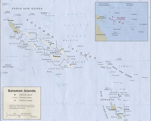
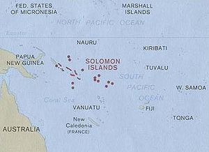
Solomon Islands is a sovereign state in Oceania, east of Papua New Guinea, consisting of nearly one thousand islands. It covers a land mass of . The capital, Honiara, is located on the island of Guadalcanal...
are a wide island nation in the South Pacific Ocean
Pacific Ocean
The Pacific Ocean is the largest of the Earth's oceanic divisions. It extends from the Arctic in the north to the Southern Ocean in the south, bounded by Asia and Australia in the west, and the Americas in the east.At 165.2 million square kilometres in area, this largest division of the World...
, that lies east of Papua New Guinea
Papua New Guinea
Papua New Guinea , officially the Independent State of Papua New Guinea, is a country in Oceania, occupying the eastern half of the island of New Guinea and numerous offshore islands...
and consists of many islands:
Choiseul
Choiseul Island
Choiseul Island, native name Lauru, is the largest island of the Choiseul Province, Solomon Islands, at .-Description:This island is named after Étienne François, duc de Choiseul....
, the Shortland Islands
Shortland Islands
The Shortland Islands are group of islands belonging to the Western Province of the Solomon Islands, at . Named by John Shortland, they lie in the extreme northwest of the country's territory, close to the island of Bougainville, Papua New Guinea. The largest island is Shortland Island...
, the New Georgia Islands
New Georgia Islands
The New Georgia Islands are part of the Western Province of the Solomon Islands. They are located to the northwest of Guadalcanal. The larger islands are mountainous and covered in rain forest. The main islands are New Georgia, Vella Lavella, Kolombangara , Ghizo, Vangunu, Rendova and Tetepare...
, Santa Isabel
Santa Isabel Island
Santa Isabel Island is the longest in the Solomon Islands, South Pacific, and the largest in the group of islands in Isabel Province.-Location and geographic data:...
, the Russell Islands
Russell Islands
The Russell Islands are two small islands, as well as several islets, of volcanic origin, in the Central Province of the Solomon Islands. They are located approximately 48 km northwest from Guadalcanal. The islands are partially covered in coconut plantations, and have a copra and oil factory at...
, the Florida Islands
Florida Islands
The Nggela Islands, also known as the Florida Islands, are a small island group in the Central Province of the Solomon Islands, a state in the southwest Pacific Ocean....
, Malaita
Malaita
Malaita is the largest island of the Malaita Province in the Solomon Islands. A tropical and mountainous island, Malaita's pristine river systems and tropical forests have not been exploited. Malaita is the most populous island of the Solomon Islands, with 140,000 people or more than a third of the...
, Guadalcanal
Guadalcanal
Guadalcanal is a tropical island in the South-Western Pacific. The largest island in the Solomons, it was discovered by the Spanish expedition of Alvaro de Mendaña in 1568...
, Sikaiana
Sikaiana
Sikaiana formerly called Stewart Islands is a small atoll 212 km NE of Malaita. It is almost 14 km in length and its lagoon, known as Te Moana, is totally enclosed by the coral reef. Its total land surface is only 2 km2...
, Maramasike, Ulawa, Uki, Makira
Makira
The island of Makira is the largest island of Makira-Ulawa Province in the Solomon Islands. The island is located east of Guadalcanal and south of Malaita. The largest and capital city is Kirakira....
(San Cristobal), Santa Ana, Rennell, Bellona
Rennell and Bellona
In 1793 Bellona Island was named after a passing British ship, the Bellona. Rennell Island may have been named for the oceanographer James Rennell, FRS . In 1799 according to a chart both islands were named Bellonas Island. In 1816 the islands were referred to as Rennell’s Isles.The names the...
and the Santa Cruz Islands
Santa Cruz Islands
The Santa Cruz Islands are a group of islands in the Pacific Ocean, part of Temotu Province of the Solomon Islands. They lie approximately 250 miles to the southeast of the Solomon Islands Chain...
. The distance between the most western and most eastern islands is about 1500 kilometre. Especially the Santa Cruz Islands
Santa Cruz Islands
The Santa Cruz Islands are a group of islands in the Pacific Ocean, part of Temotu Province of the Solomon Islands. They lie approximately 250 miles to the southeast of the Solomon Islands Chain...
, North of Vanuatu
Vanuatu
Vanuatu , officially the Republic of Vanuatu , is an island nation located in the South Pacific Ocean. The archipelago, which is of volcanic origin, is some east of northern Australia, northeast of New Caledonia, west of Fiji, and southeast of the Solomon Islands, near New Guinea.Vanuatu was...
, (of which Tikopia
Tikopia
Tikopia is a small and high island in the southwestern Pacific Ocean. Covering an area of 5 km² , the island is the remnant of an extinct volcano. Its highest point, Mt. Reani, reaches an elevation of 380 m above sea level. Lake Te Roto covers an old volcanic crater which is 80 m...
is part) are isolated at more than 200 kilometre from the other islands.
Volcano
Volcano
2. Bedrock3. Conduit 4. Base5. Sill6. Dike7. Layers of ash emitted by the volcano8. Flank| 9. Layers of lava emitted by the volcano10. Throat11. Parasitic cone12. Lava flow13. Vent14. Crater15...
es with varying degrees of activity are situated on some of the larger islands, while many of the smaller islands are simply tiny atoll
Atoll
An atoll is a coral island that encircles a lagoon partially or completely.- Usage :The word atoll comes from the Dhivehi word atholhu OED...
s covered in sand and palm trees.
Bougainville
Bougainville Island
Bougainville Island is the main island of the Autonomous Region of Bougainville of Papua New Guinea. This region is also known as Bougainville Province or the North Solomons. The population of the province is 175,160 , which includes the adjacent island of Buka and assorted outlying islands...
is geographically part of the Solomon Islands, but politically Papua New Guinea
Papua New Guinea
Papua New Guinea , officially the Independent State of Papua New Guinea, is a country in Oceania, occupying the eastern half of the island of New Guinea and numerous offshore islands...
.
Climate
The climate is tropical, though temperatures are rarely extreme due to cooling winds blowing off the surrounding seas. Daytime temperatures are normally 25 to 32 degrees Celsius (77 to 90 °F), falling about 13 to 15 °C (59 °F) at night. From April to October (the Dry Season), the Southeast trade winds blow, gusting at times up to 30 knots (55 km/h) or more. November to March is the wet season—the northwest monsoonMonsoon
Monsoon is traditionally defined as a seasonal reversing wind accompanied by corresponding changes in precipitation, but is now used to describe seasonal changes in atmospheric circulation and precipitation associated with the asymmetric heating of land and sea...
—typically warmer and wetter. Cyclones arise in the Coral Sea and the area of the Solomon Islands, but they usually veer toward Vanuatu
Vanuatu
Vanuatu , officially the Republic of Vanuatu , is an island nation located in the South Pacific Ocean. The archipelago, which is of volcanic origin, is some east of northern Australia, northeast of New Caledonia, west of Fiji, and southeast of the Solomon Islands, near New Guinea.Vanuatu was...
and New Caledonia
New Caledonia
New Caledonia is a special collectivity of France located in the southwest Pacific Ocean, east of Australia and about from Metropolitan France. The archipelago, part of the Melanesia subregion, includes the main island of Grande Terre, the Loyalty Islands, the Belep archipelago, the Isle of...
or down the coast of Australia
Australia
Australia , officially the Commonwealth of Australia, is a country in the Southern Hemisphere comprising the mainland of the Australian continent, the island of Tasmania, and numerous smaller islands in the Indian and Pacific Oceans. It is the world's sixth-largest country by total area...
.
Map references: Oceania
Area:
total:
28,450 km² (10,985 mi²)
land:
27,540 km² (10,633 mi²)
water:
910 km² (351 mi²)
Area - comparative: Slightly smaller than the U.S. state of Maryland
Maryland
Maryland is a U.S. state located in the Mid Atlantic region of the United States, bordering Virginia, West Virginia, and the District of Columbia to its south and west; Pennsylvania to its north; and Delaware to its east...
Land boundaries: 0 km
Coastline: 5,313 km
Maritime claims:
Measured from claimed archipelagic baselines
continental shelf:
200 nmi (230.2 mi; 370.4 km)
exclusive economic zone:
200 nmi (230.2 mi; 370.4 km)
territorial sea: 12 nmi (14 mi; 22 km)
Terrain: Mostly rugged mountains with some low coral atolls
Elevation extremes:
lowest point:
Pacific Ocean 0 m
highest point:
Mount Popomanaseu
Mount Popomanaseu
Mount Popomanaseu is the highest mountain in the Solomon Islands. It is located on Guadalcanal east of Mount Makarakomburu. At , it is the highest peak in the insular South Pacific, excluding New Guinea and it's satellite islands. Panning east across the South Pacific, there is no higher mountain...
2,332 m (7,651 ft) (not Mount Makarakomburu
Mount Makarakomburu
Mount Makarakomburu is the second highest point in the Solomon Islands, located approximately 20 miles south of Honiara, the capital, on the island of Guadalcanal, which is the largest island in the country.-Elevation:...
)
Natural resources: fish
Fish
Fish are a paraphyletic group of organisms that consist of all gill-bearing aquatic vertebrate animals that lack limbs with digits. Included in this definition are the living hagfish, lampreys, and cartilaginous and bony fish, as well as various extinct related groups...
, forest
Forest
A forest, also referred to as a wood or the woods, is an area with a high density of trees. As with cities, depending where you are in the world, what is considered a forest may vary significantly in size and have various classification according to how and what of the forest is composed...
s, gold
Gold
Gold is a chemical element with the symbol Au and an atomic number of 79. Gold is a dense, soft, shiny, malleable and ductile metal. Pure gold has a bright yellow color and luster traditionally considered attractive, which it maintains without oxidizing in air or water. Chemically, gold is a...
, bauxite
Bauxite
Bauxite is an aluminium ore and is the main source of aluminium. This form of rock consists mostly of the minerals gibbsite Al3, boehmite γ-AlO, and diaspore α-AlO, in a mixture with the two iron oxides goethite and hematite, the clay mineral kaolinite, and small amounts of anatase TiO2...
, phosphate
Phosphate
A phosphate, an inorganic chemical, is a salt of phosphoric acid. In organic chemistry, a phosphate, or organophosphate, is an ester of phosphoric acid. Organic phosphates are important in biochemistry and biogeochemistry or ecology. Inorganic phosphates are mined to obtain phosphorus for use in...
s, lead
Lead
Lead is a main-group element in the carbon group with the symbol Pb and atomic number 82. Lead is a soft, malleable poor metal. It is also counted as one of the heavy metals. Metallic lead has a bluish-white color after being freshly cut, but it soon tarnishes to a dull grayish color when exposed...
, zinc
Zinc
Zinc , or spelter , is a metallic chemical element; it has the symbol Zn and atomic number 30. It is the first element in group 12 of the periodic table. Zinc is, in some respects, chemically similar to magnesium, because its ion is of similar size and its only common oxidation state is +2...
, nickel
Nickel
Nickel is a chemical element with the chemical symbol Ni and atomic number 28. It is a silvery-white lustrous metal with a slight golden tinge. Nickel belongs to the transition metals and is hard and ductile...
Land use:
arable land:
1%
permanent crops:
1%
permanent pastures:
1%
forests and woodland:
88%
other:
9% (1993 est.)
Irrigated land: NA
Natural hazards: Typhoons, but they are rarely destructive; geologically active region with frequent earth tremors; volcanic activity
Environment - current issues: Deforestation
Deforestation
Deforestation is the removal of a forest or stand of trees where the land is thereafter converted to a nonforest use. Examples of deforestation include conversion of forestland to farms, ranches, or urban use....
; soil erosion; much of the surrounding coral reef
Coral reef
Coral reefs are underwater structures made from calcium carbonate secreted by corals. Coral reefs are colonies of tiny living animals found in marine waters that contain few nutrients. Most coral reefs are built from stony corals, which in turn consist of polyps that cluster in groups. The polyps...
s are dead or dying
Environment - international agreements:
party to: Biodiversity
Biodiversity
Biodiversity is the degree of variation of life forms within a given ecosystem, biome, or an entire planet. Biodiversity is a measure of the health of ecosystems. Biodiversity is in part a function of climate. In terrestrial habitats, tropical regions are typically rich whereas polar regions...
, Climate Change
United Nations Framework Convention on Climate Change
The United Nations Framework Convention on Climate Change is an international environmental treaty produced at the United Nations Conference on Environment and Development , informally known as the Earth Summit, held in Rio de Janeiro from June 3 to 14, 1992...
, Desertification
Desertification
Desertification is the degradation of land in drylands. Caused by a variety of factors, such as climate change and human activities, desertification is one of the most significant global environmental problems.-Definitions:...
, Environmental Modification, Law of the Sea
Law of the sea
Law of the sea may refer to:* United Nations Convention on the Law of the Sea* Admiralty law* The Custom of the Sea...
, Marine Dumping, Marine Life Conservation, Ozone Layer Protection, Whaling
Whaling
Whaling is the hunting of whales mainly for meat and oil. Its earliest forms date to at least 3000 BC. Various coastal communities have long histories of sustenance whaling and harvesting beached whales...
signed, but not ratified:
Climate Change-Kyoto Protocol
Kyoto Protocol
The Kyoto Protocol is a protocol to the United Nations Framework Convention on Climate Change , aimed at fighting global warming...
Extreme points
This is a list of the extreme points of the Solomon IslandsSolomon Islands
Solomon Islands is a sovereign state in Oceania, east of Papua New Guinea, consisting of nearly one thousand islands. It covers a land mass of . The capital, Honiara, is located on the island of Guadalcanal...
, the points that are farther north, south, east or west than any other location.
- Northern-most point – Ontong Java AtollOntong Java AtollOntong Java Atoll or Luangiua is one of the largest atolls on earth. It is sometimes referred to as Lord Howe Atoll, not to be confused with Lord Howe Island.-Description:Administratively Ontong Java belongs to the Solomon Islands...
, Malaita ProvinceMalaita ProvinceMalaita Province is one of the largest provinces of the Solomon Islands. It is named for its largest island, Malaita . Other islands include South Malaita Island , Sikaiana Island, and Ontong Java Atoll. The provincial capital and largest urban center is Auki, located on Big Malaita... - Eastern-most point – FatutakaFatutakaFatutaka, Fatu Taka or Patu Taka is a small high island in the Solomon Islands province of Temotu. It is the easternmost landfall in that nation. The island, located at , is the remnant of an extinct volcano. It is a small rocky outcropping, rising to an elevation of . The total land area of the...
, Santa Cruz IslandsSanta Cruz IslandsThe Santa Cruz Islands are a group of islands in the Pacific Ocean, part of Temotu Province of the Solomon Islands. They lie approximately 250 miles to the southeast of the Solomon Islands Chain...
, Temotu ProvinceTemotu ProvinceTemotu is the easternmost province of the Solomon Islands. The province was formerly known as Santa Cruz Islands Province. It consists, essentially, of two chains of islands which run parallel to each other from the northwest to the southeast.- Islands :... - Southern-most point – South Reef, Indispensable ReefIndispensable ReefThe Indispensable Reefs are a chain of three large coral atolls in the Coral Sea. They are located about 50 km south of Rennell Island, separated from it by Rennel Trough...
, Rennell and Bellona Province - Western-most point - Mono IslandMono IslandMono Island is the largest island of the Treasury Islands, Solomon Islands, at .- Geography :Mono island is a volcanic island in the northwest of the Solomon Islands. It is separated by the Blanche Harbour from Stirling Island and the other coral islands surrounding it. The village of Falamai is...
, Treasury IslandsTreasury IslandsTreasury Islands are a small group of islands a few kilometers to the south of Bougainville and 24 kilometers from the Shortland Islands. They form part of the Western Province of the Solomon Islands. The two largest islands in the Treasuries are Mono Island and the smaller Stirling Island...
, Western Province
See also
- Islands of the Solomon IslandsIslands of the Solomon IslandsThis is a list of islands of the Solomon Islands, by province and archipelago.*Choiseul Province**Choiseul Island**Taro Island**Vaghena Island *Western Province**Shortland Islands***Magusaiai***Alu Island ***Pirumeri...
- List of mammals of the Solomon Islands