

Geography of the Alps
Encyclopedia
Alps
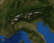
The Alps is one of the great mountain range systems of Europe, stretching from Austria and Slovenia in the east through Italy, Switzerland, Liechtenstein and Germany to France in the west....
cover a large area. This article describes the delimitation
Boundary delimitation
Boundary delimitation, or simply delimitation, is the term used to describe the drawing of boundaries, but is most often used to describe the drawing of electoral boundaries, specifically those of precincts, states, counties or other municipalities...
of the Alps as a whole and of subdivisions of the range, follows the course of the main chain of the Alps and discusses the lakes and glaciers found in the region.
Central Europe
Central Europe or alternatively Middle Europe is a region of the European continent lying between the variously defined areas of Eastern and Western Europe...
, including parts of Italy
Italy
Italy , officially the Italian Republic languages]] under the European Charter for Regional or Minority Languages. In each of these, Italy's official name is as follows:;;;;;;;;), is a unitary parliamentary republic in South-Central Europe. To the north it borders France, Switzerland, Austria and...
, France
France
The French Republic , The French Republic , The French Republic , (commonly known as France , is a unitary semi-presidential republic in Western Europe with several overseas territories and islands located on other continents and in the Indian, Pacific, and Atlantic oceans. Metropolitan France...
, Switzerland
Switzerland
Switzerland name of one of the Swiss cantons. ; ; ; or ), in its full name the Swiss Confederation , is a federal republic consisting of 26 cantons, with Bern as the seat of the federal authorities. The country is situated in Western Europe,Or Central Europe depending on the definition....
, Liechtenstein
Liechtenstein
The Principality of Liechtenstein is a doubly landlocked alpine country in Central Europe, bordered by Switzerland to the west and south and by Austria to the east. Its area is just over , and it has an estimated population of 35,000. Its capital is Vaduz. The biggest town is Schaan...
, Austria
Austria
Austria , officially the Republic of Austria , is a landlocked country of roughly 8.4 million people in Central Europe. It is bordered by the Czech Republic and Germany to the north, Slovakia and Hungary to the east, Slovenia and Italy to the south, and Switzerland and Liechtenstein to the...
, Slovenia
Slovenia
Slovenia , officially the Republic of Slovenia , is a country in Central and Southeastern Europe touching the Alps and bordering the Mediterranean. Slovenia borders Italy to the west, Croatia to the south and east, Hungary to the northeast, and Austria to the north, and also has a small portion of...
, Germany
Germany
Germany , officially the Federal Republic of Germany , is a federal parliamentary republic in Europe. The country consists of 16 states while the capital and largest city is Berlin. Germany covers an area of 357,021 km2 and has a largely temperate seasonal climate...
and possibly Hungary
Hungary
Hungary , officially the Republic of Hungary , is a landlocked country in Central Europe. It is situated in the Carpathian Basin and is bordered by Slovakia to the north, Ukraine and Romania to the east, Serbia and Croatia to the south, Slovenia to the southwest and Austria to the west. The...
(if one includes the Günser Gebirge or the Ödenburger Gebirge in the Alps). In some areas, such as the edge of the Po Basin, the edge of the range is unambiguous, but where the Alps border on other mountainous or hilly regions, the border may be harder to place. These neighbouring ranges include the Apennines
Apennine mountains
The Apennines or Apennine Mountains or Greek oros but just as often used alone as a noun. The ancient Greeks and Romans typically but not always used "mountain" in the singular to mean one or a range; thus, "the Apennine mountain" refers to the entire chain and is translated "the Apennine...
, the Massif Central
Massif Central
The Massif Central is an elevated region in south-central France, consisting of mountains and plateaux....
, the Jura
Jura mountains
The Jura Mountains are a small mountain range located north of the Alps, separating the Rhine and Rhone rivers and forming part of the watershed of each...
, the Black Forest
Black Forest
The Black Forest is a wooded mountain range in Baden-Württemberg, southwestern Germany. It is bordered by the Rhine valley to the west and south. The highest peak is the Feldberg with an elevation of 1,493 metres ....
, the Böhmerwald
Bohemian Forest
The Bohemian Forest, also known in Czech as Šumava , is a low mountain range in Central Europe. Geographically, the mountains extend from South Bohemia in the Czech Republic to Austria and Bavaria in Germany...
, the Carpathians
Carpathian Mountains
The Carpathian Mountains or Carpathians are a range of mountains forming an arc roughly long across Central and Eastern Europe, making them the second-longest mountain range in Europe...
, and the mountains of the Balkan Peninsula.
The boundary between the Apennines and the Alps is usually taken to be the Colle di Cadibona
Colle di Cadibona
Colle di Cadibona is a mountain pass between Savona and Ceva in the Ligurian Alps, delineating the boundary with the Apennine Mountains....
, at 435 m above sea level, above Savona
Savona
Savona is a seaport and comune in the northern Italian region of Liguria, capital of the Province of Savona, in the Riviera di Ponente on the Mediterranean Sea....
on the Italian coast.
The River Rhône
Rhône River
The Rhone is one of the major rivers of Europe, rising in Switzerland and running from there through southeastern France. At Arles, near its mouth on the Mediterranean Sea, the river divides into two branches, known as the Great Rhone and the Little Rhone...
forms a clear boundary between the tectonically-formed Alps from the largely volcanically
Volcanism
Volcanism is the phenomenon connected with volcanoes and volcanic activity. It includes all phenomena resulting from and causing magma within the crust or mantle of a planet to rise through the crust and form volcanic rocks on the surface....
-formed Massif Central. Working upstream, the River Rhône turns to the east near Lyon
Lyon
Lyon , is a city in east-central France in the Rhône-Alpes region, situated between Paris and Marseille. Lyon is located at from Paris, from Marseille, from Geneva, from Turin, and from Barcelona. The residents of the city are called Lyonnais....
, and forms part of the boundary between the Alps and the Jura that ends at Lake Geneva
Lake Geneva
Lake Geneva or Lake Léman is a lake in Switzerland and France. It is one of the largest lakes in Western Europe. 59.53 % of it comes under the jurisdiction of Switzerland , and 40.47 % under France...
. An area of flat ground reaches from there to Lake Neuchâtel
Lake Neuchâtel
Lake Neuchâtel is a lake in Romandy, Switzerland . The lake lies mainly in the canton of Neuchâtel, but is also shared by the cantons of Vaud, of Fribourg, and of Bern....
, continuing the border, with the Jura to the north-west and the Alps to the south east. From Lake Neuchâtel to its confluence with the River Rhine, the Aar forms the border.
The Black Forest is separated from the Alps by the River Rhine and Lake Constance
Lake Constance
Lake Constance is a lake on the Rhine at the northern foot of the Alps, and consists of three bodies of water: the Obersee , the Untersee , and a connecting stretch of the Rhine, called the Seerhein.The lake is situated in Germany, Switzerland and Austria near the Alps...
, but exact delimitation is difficult in southern Germany, where the land gently slopes up to meet the mountains (known in German as the Schwäbisch-Bayerisches Alpenvorland, the "Swabian-Bavarian pre-Alps").
In Austria, the Danube
Danube
The Danube is a river in the Central Europe and the Europe's second longest river after the Volga. It is classified as an international waterway....
runs to the north of the Alps, separating it from the majority of the Böhmerwald
Bohemian Forest
The Bohemian Forest, also known in Czech as Šumava , is a low mountain range in Central Europe. Geographically, the mountains extend from South Bohemia in the Czech Republic to Austria and Bavaria in Germany...
, although some small areas, such as the Dunkelsteiner Wald south of the Wachau
Wachau
The Wachau is an Austrian valley with a picturesque landscape formed by the Danube river. It is one of the most prominent tourist destinations of Lower Austria, located midway between the towns of Melk and Krems that also attracts "connoisseurs and epicureans". It is in length and was already...
, belong geologically to the Böhmerwald
Bohemian Forest
The Bohemian Forest, also known in Czech as Šumava , is a low mountain range in Central Europe. Geographically, the mountains extend from South Bohemia in the Czech Republic to Austria and Bavaria in Germany...
despite being south of the Danube
Danube
The Danube is a river in the Central Europe and the Europe's second longest river after the Volga. It is classified as an international waterway....
. The Wienerwald
Wienerwald
The Vienna Woods are forested highlands that form the northeastern foothills of the Northern Limestone Alps in the states of Lower Austria and Vienna. The long and wide hill range is heavily wooded and a popular recreation area with the Viennese....
near Vienna
Vienna
Vienna is the capital and largest city of the Republic of Austria and one of the nine states of Austria. Vienna is Austria's primary city, with a population of about 1.723 million , and is by far the largest city in Austria, as well as its cultural, economic, and political centre...
forms the north-eastern corner of the Alps, and here the Danube passes at its closest to the Alps (see Viennese Basin).
East of Vienna, only the Marchfeld, a 30-km wide flood plain separates the easternmost Alps from the Lesser Carpathians. After Vienna, the Pannonian Basin
Pannonian Basin
The Pannonian Basin or Carpathian Basin is a large basin in East-Central Europe.The geomorphological term Pannonian Plain is more widely used for roughly the same region though with a somewhat different sense - meaning only the lowlands, the plain that remained when the Pliocene Pannonian Sea dried...
, a large area of steppe
Steppe
In physical geography, steppe is an ecoregion, in the montane grasslands and shrublands and temperate grasslands, savannas, and shrublands biomes, characterized by grassland plains without trees apart from those near rivers and lakes...
, meets the edge of the Alps, clearly delimiting the eastern limit of the Alps.
The south-easternmost extension of the Alps is to be found in Slovenia
Slovenia
Slovenia , officially the Republic of Slovenia , is a country in Central and Southeastern Europe touching the Alps and bordering the Mediterranean. Slovenia borders Italy to the west, Croatia to the south and east, Hungary to the northeast, and Austria to the north, and also has a small portion of...
, including Pohorje
Pohorje
Pohorje is a mountain range in northern Slovenia, near the towns of Dravograd and Maribor. Made of metamorphic rock, it is geologically part of the Central Eastern Alps, though due to its location south of the Drava River it is commonly regarded as a Southern Limestone Alps range.-Peaks:The most...
, the Kamnik Alps
Kamnik Alps
The Kamnik–Savinja Alps are a mountain range, part of the Southern Limestone Alps in north Slovenia and at the border with Austria. Its western part, the Kamnik Alps, is in the basin of the Kamniška Bistrica and is named after the town Kamnik. Its eastern part is in the basin of Savinja and is...
and the Julian Alps
Julian Alps
The Julian Alps are a mountain range of the Southern Limestone Alps that stretches from northeastern Italy to Slovenia, where they rise to 2,864 m at Mount Triglav. They are named after Julius Caesar, who founded the municipium of Cividale del Friuli at the foot of the mountains...
(the last being shared with Italy). The town of Idrija
Idrija
Idrija is a small town and municipality in the Goriška region of Slovenia. It is known for its mercury mine and lace....
may be taken as marking the dividing line between the Alps to the north and the Karst
KARST
Kilometer-square Area Radio Synthesis Telescope is a Chinese telescope project to which FAST is a forerunner. KARST is a set of large spherical reflectors on karst landforms, which are bowlshaped limestone sinkholes named after the Kras region in Slovenia and Northern Italy. It will consist of...
plateau to the south, which then leads on to the mountains of the Balkan Peninsula.
The remainder of the southern edge of the Alps is clearly delimited by the basin of the River Po.
This delimitation of the Alps is, however, largely subjective and open to argument. In particular, some people restrict the use of the term "Alps" to the higher mountains in the centre of the range, relegating the surrounding hills and mountains to the status of "pre-Alps" or foothills. This can sometimes lead to conflicting definitions, such as Mont Ventoux
Mont Ventoux
Mont Ventoux is a mountain in the Provence region of southern France, located some 20 km northeast of Carpentras, Vaucluse. On the north side, the mountain borders the Drôme département. It is the largest mountain in the region and has been nicknamed the "Giant of Provence", or "The Bald...
being considered to lie outside the Alps (there are no comparably sized mountains around it, and it is at a considerable distance from the main chain of the Alps).
It is also not possible to define the Alps geologically, since the same orogenous
Orogeny
Orogeny refers to forces and events leading to a severe structural deformation of the Earth's crust due to the engagement of tectonic plates. Response to such engagement results in the formation of long tracts of highly deformed rock called orogens or orogenic belts...
events that created the Alps also created neighbouring ranges such as the Carpathians. See also Geology of the Alps
Geology of the Alps
The Alps form part of a Tertiary orogenic belt of mountain chains, called the Alpide belt, that stretches through southern Europe and Asia from the Atlantic all the way to the Himalayas. This belt of mountain chains was formed during the Alpine orogeny. A gap in these mountain chains in central...
. The Alps are a distinct physiographic province of the larger Alpine System physiographic division, but the Alps are composed of three distinct physiographic sections, the Eastern, Western and Southern Alps physiographic sections.
Subdivisions
While smaller groups within the Alps may be easily defined by the passes on either side, defining larger units can be problematic. A traditional divide exists between the Western Alps and the Eastern AlpsEastern Alps
Eastern Alps is the name given to the eastern half of the Alps, usually defined as the area east of the Splügen Pass in eastern Switzerland. North of the Splügen Pass, the Posterior Rhine forms the border, and south of the pass, the Liro river and Lake Como form the boundary line.-Geography:The...
, which uses the Splügen Pass
Splügen Pass
The Splügen Pass is a high mountain pass which marks the boundary between the Lepontine and Rhaetian Alps....
on the Swiss-Italian border, together with the Rhine to the north and Lake Como
Lake Como
Lake Como is a lake of glacial origin in Lombardy, Italy. It has an area of 146 km², making it the third largest lake in Italy, after Lake Garda and Lake Maggiore...
in the south as the defining features. While the Splügen Pass is neither the lowest nor the most important pass in the Alps, it is approximately half-way along the main chain, and makes a convenient boundary.
Eastern Alps
The Eastern AlpsEastern Alps
Eastern Alps is the name given to the eastern half of the Alps, usually defined as the area east of the Splügen Pass in eastern Switzerland. North of the Splügen Pass, the Posterior Rhine forms the border, and south of the pass, the Liro river and Lake Como form the boundary line.-Geography:The...
are commonly subdivided according to the different lithology
Lithology
The lithology of a rock unit is a description of its physical characteristics visible at outcrop, in hand or core samples or with low magnification microscopy, such as colour, texture, grain size, or composition. It may be either a detailed description of these characteristics or be a summary of...
(rock composition) of the more central parts of the Alps and the groups at its northern and southern fringes:
- Flysch zoneFlyschFlysch is a sequence of sedimentary rocks that is deposited in a deep marine facies in the foreland basin of a developing orogen. Flysch is typically deposited during an early stage of the orogenesis. When the orogen evolves the foreland basin becomes shallower and molasse is deposited on top of...
(up from the Vienna woodsWienerwaldThe Vienna Woods are forested highlands that form the northeastern foothills of the Northern Limestone Alps in the states of Lower Austria and Vienna. The long and wide hill range is heavily wooded and a popular recreation area with the Viennese....
to BregenzerwaldBregenzerwaldBregenzerwald is one of the main regions in the state of Vorarlberg, Austria. Geologically, the Bregenzerwald is a mountain range of the Northern Limestone Alps, specifically the northern flysch zone. It is the drainage basin of the Bregenzer Ach river....
. The Swiss JuraJura mountainsThe Jura Mountains are a small mountain range located north of the Alps, separating the Rhine and Rhone rivers and forming part of the watershed of each...
do geographically not belong to the Alps; - Northern Limestone AlpsNorthern Limestone AlpsThe Northern Limestone Alps are the ranges of the Eastern Alps north of the Central Eastern Alps located in Austria and the adjacent Bavarian lands of southeastern Germany. The distinction from the latter group, where the higher peaks are located, is based on differences in geological composition...
, peaks up to 3000 m; - Central Eastern AlpsCentral Eastern AlpsThe Central Eastern Alps comprise the main chain of the Eastern Alps with its highest peaks, located between the Northern Limestone Alps and the Southern Limestone Alps, from which they differ in geological composition....
(Austria, Swiss), peaks up to 4050 m; - Southern Limestone AlpsSouthern Limestone AlpsThe Southern Limestone Alps are the ranges of the Eastern Alps south of the Central Eastern Alps mainly located in northern Italy and the adjacent lands of Austria and Slovenia. The distinction from the Central Alps, where the higher peaks are located, is based on differences in geological...
, peaks up to 3500 m.
The border between the Central Alps and the Southern Limestone Alps is the Periadriatic Seam
Periadriatic Seam
The Periadriatic Seam is a distinct geologic fault in Southern Europe, running S-shaped about 1000 km from the Tyrrhenian Sea through the whole Southern Alps as far as Hungary. It forms the division between the Adriatic plate and the European plate...
. The Northern Limestone Alps are separated from the Central Eastern Alps by the Grauwacken Zone
Greywacke zone
The greywacke zone is a band of Paleozoic metamorphosed sedimentary rocks that forms an east-west band through the Austrian Alps. The greywacke zone crops out between the Mesozoic rocks of the Northern Calcareous Alps and the Austroalpine and Penninic basement rocks of the Central Eastern Alps....
.
However, the geologic subdivision, based on tectonics
Tectonics
Tectonics is a field of study within geology concerned generally with the structures within the lithosphere of the Earth and particularly with the forces and movements that have operated in a region to create these structures.Tectonics is concerned with the orogenies and tectonic development of...
, suggests a different system:
- The HelveticHelvetic nappesThe Helvetic zone, Helvetic system or the Helveticum is a geologic subdivision of the Alps. The Helvetic zone crops out mainly in Switzerland, hence the name . Rocks in the Helvetic zone are sedimentary and were originally deposited at the southern margin of the European plate...
system in the north (including the Jura mountains), - the PenninicPenninic nappesThe Penninic nappes or the Penninicum are one of three nappe stacks and geological zones in which the Alps can be divided. In the western Alps the Penninic nappes are more obviously present than in the eastern Alps , where they crop out as a narrow band...
system: mainly Central Alps (Engadine and "Tauern windowHohe Tauern windowThe Hohe Tauern window is a geological structure in the Austrian Central Eastern Alps. It is a window in the Austroalpine nappes where high-grade metamorphic rocks of the underlying Penninic nappes crop out...
") and Flysch Alps, - the AustroalpineAustroalpine nappesThe Austroalpine nappes are a geological nappe stack in the European Alps. The Alps contain three such stacks, of which the Austroalpine nappes are structurally on top of the other two...
system: Northern Limestone AlpsNorthern Limestone AlpsThe Northern Limestone Alps are the ranges of the Eastern Alps north of the Central Eastern Alps located in Austria and the adjacent Bavarian lands of southeastern Germany. The distinction from the latter group, where the higher peaks are located, is based on differences in geological composition...
, Graywacke-SchistSchistThe schists constitute a group of medium-grade metamorphic rocks, chiefly notable for the preponderance of lamellar minerals such as micas, chlorite, talc, hornblende, graphite, and others. Quartz often occurs in drawn-out grains to such an extent that a particular form called quartz schist is...
zone, Central CrystallineBasement (geology)In geology, the terms basement and crystalline basement are used to define the rocks below a sedimentary platform or cover, or more generally any rock below sedimentary rocks or sedimentary basins that are metamorphic or igneous in origin...
, - the Southern AlpsSouthern Alps (geology)The Southern Alps are a geological subdivision of the European Alps. The Southern Alps are the part of the Alps that are found south of the Periadriatic Seam, a major geological faultzone across the Alps...
(Southern Limestone Alps and other chains south of the Periadriatic Seam) - south of a huge geologic faultGeologic faultIn geology, a fault is a planar fracture or discontinuity in a volume of rock, across which there has been significant displacement along the fractures as a result of earth movement. Large faults within the Earth's crust result from the action of tectonic forces...
("alpine-dinaric seam") parts of the Dinarides.
Western Alps
The Western Alps are commonly subdivided into the following:
- Ligurian AlpsLigurian AlpsThe Ligurian Alps are a mountain range in northwestern Italy. A small part is located in France. They form the south-western extremity of the Alps, separated from the Apennines by the Colle di Cadibona. The Col de Tende separates them from the Maritime Alps...
(from SavonaSavonaSavona is a seaport and comune in the northern Italian region of Liguria, capital of the Province of Savona, in the Riviera di Ponente on the Mediterranean Sea....
to Colle di Tenda) - Maritime AlpsMaritime AlpsThe Maritime Alps are a mountain range in the southwestern part of the Alps. They form the border between the French département Alpes-Maritimes and the Italian province of Cuneo. The Col de Tende separates them from the Ligurian Alps; the Maddalena Pass separates them from the Cottian Alps...
(from Colle di Tenda to Colle de la Maddalena) - Cottian AlpsCottian AlpsThe Cottian Alps are a mountain range in the southwestern part of the Alps. They form the border between France and Italy...
(from Colle de la Maddalena to Col du Mont Genevre) - Dauphiné AlpsDauphiné AlpsThe Dauphiné Alps are a group of mountain ranges in southeastern France, west of the main chain of the Alps. They are separated from the Cottian Alps in the east by the Col du Galibier and the upper Durance valley; from the western Graian Alps in the north-east by the river Arc; from the lower...
(from Col du Mont Genevre to Col du Mont Cenis) - Graian AlpsGraian AlpsThe Graian Alps are a mountain range in the western part of the Alps. They are located in France , Italy , and Switzerland...
(from Col du Mont Cenis to the Little Saint Bernard PassLittle St Bernard PassThe Little St Bernard Pass is a mountain pass in the Alps on the France–Italy border. Its saddle is at 2188 metres above sea level. It is located between Savoie, France and Aosta Valley, Italy to the south of the Mont Blanc Massif, precisely on the main alpine watershed. There is also a Great St...
) - Chablais AlpsChablais AlpsThe Chablais Alps are a mountain range in the western Alps. They are situated between Lake Geneva and the Mont Blanc Massif. The Col des Montets separates them from the Mont Blanc Massif in the south, and the Rhône valley separates them from the Bernese Alps in the east.The Chablais Alps are...
(from Lake GenevaLake GenevaLake Geneva or Lake Léman is a lake in Switzerland and France. It is one of the largest lakes in Western Europe. 59.53 % of it comes under the jurisdiction of Switzerland , and 40.47 % under France...
to the Col des MontetsCol des MontetsCol des Montets is a mountain pass in the French Alps in the Haute-Savoie department of France. It is on the road between Chamonix and Martigny in the canton of Valais, Switzerland.It lies between the Swiss Col de la Forclaz and Chamonix....
) - Pennine AlpsPennine AlpsThe Pennine Alps are a mountain range in the western part of the Alps. They are located in Switzerland and Italy...
(from the Little St. Bernard Pass to the Simplon PassSimplon PassSimplon Pass is a high mountain pass between the Pennine Alps and the Lepontine Alps in Switzerland. It connects Brig in the canton of Valais with Domodossola in Piedmont . The pass itself and the villages on each side of it, such as Gondo, are in Switzerland...
) - Lepontine AlpsLepontine AlpsThe Lepontine Alps are a mountain range in the central part of the Alps. They are located in Switzerland and Italy .On the north the upper Rhône valley separate them from the Bernese Alps and the Furka Pass and the upper Reuss valley separates them from the Urner Alps; on the west the Simplon Pass...
(from Simplon Pass to Splügen PassSplügen PassThe Splügen Pass is a high mountain pass which marks the boundary between the Lepontine and Rhaetian Alps....
) - Bernese AlpsBernese AlpsThe Bernese Alps are a group of mountain ranges in the western part of the Alps, in Switzerland. Although the name suggests that they are located in the Bernese Oberland region of the canton of Bern, portions of the Bernese Alps are in the adjacent cantons of Valais, Lucerne, Obwalden, Fribourg and...
(north of the RhôneRhôneRhone can refer to:* Rhone, one of the major rivers of Europe, running through Switzerland and France* Rhône Glacier, the source of the Rhone River and one of the primary contributors to Lake Geneva in the far eastern end of the canton of Valais in Switzerland...
to the Grimsel PassGrimsel PassGrimsel Pass is a Swiss high mountain pass.-Position:It connects the valley of the Rhone River in the canton of Valais and the Haslital in the canton of Bern....
) - Urner AlpsUrner AlpsThe Urner Alps are a mountain range in central Switzerland in the western part of the Alps. They extend into the cantons of Obwalden, Valais, Lucerne, Bern, Uri and Nidwalden and are bordered by the Bernese Alps to the west, the Lepontine Alps to the south and the Glarus Alps to the east.The Urner...
(from Grimsel Pass to the Reuss river) - Glarus AlpsGlarus AlpsThe Glarus Alps are a mountain range in central Switzerland. They extend from the Oberalp Pass to the Klausen Pass, and are bordered by the Urner Alps to the west, the Lepontine Alps to the south and the Appenzell Alps to the northeast...
(north-east of Oberalp PassOberalp PassOberalp Pass is a high mountain pass in the Swiss Alps connecting the cantons of Graubünden and Uri between Disentis and Andermatt.-Winter closure:...
) - Appenzell AlpsAppenzell AlpsThe Appenzell Alps are a mountain range in Switzerland on the northern edge of the Alps. They extend into the cantons of Appenzell Ausserrhoden, Appenzell Innerrhoden and St...
(north of SargansSargansSargans is a municipality in the Wahlkreis of Sarganserland in the canton of St. Gallen in Switzerland.Sargans is known for its castle, which dates from before the founding of the Swiss Confederation in 1291...
)
Within the Eastern Alps, the most widely used subdivision is the Alpine Club's 1984 classification
Alpine Club classification of the Eastern Alps
The Alpine Club classification of the Eastern Alps or AVE is a division of the Eastern Alps into 75 mountain groups and is commonly used in mountaineering...
, which divides the region into about seventy small areas.
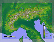
Main chain
The "main chain of the Alps" follows the watershed from the Mediterranean to the WienerwaldWienerwald
The Vienna Woods are forested highlands that form the northeastern foothills of the Northern Limestone Alps in the states of Lower Austria and Vienna. The long and wide hill range is heavily wooded and a popular recreation area with the Viennese....
, passing over many of the highest and most famous peaks in the Alps. The most important passes and peaks which it crosses are given below (mountains are indented, passes unindented). From the Colle di Cadibona to Col de Tende
Col de Tende
Col de Tende is a high mountain pass in the Alps, on the border of France and Italy.It separates the Maritime Alps from the Ligurian Alps. It connects Nice and Tende in Alpes-Maritimes with Cuneo in Piedmont....
it runs westwards, before turning to the north-west and then, near the Colle de la Maddalena, to the north. Upon reaching the Swiss border, the line of the main chain heads approximately east-north-east, a heading it follows until its end near Vienna
Vienna
Vienna is the capital and largest city of the Republic of Austria and one of the nine states of Austria. Vienna is Austria's primary city, with a population of about 1.723 million , and is by far the largest city in Austria, as well as its cultural, economic, and political centre...
.
- Colle di CadibonaColle di CadibonaColle di Cadibona is a mountain pass between Savona and Ceva in the Ligurian Alps, delineating the boundary with the Apennine Mountains....
- Colle di Tenda / Col de Tende ( / , 1908 m)
- Colle della Maddalena / Col du Larche ( / , 1994 m)
- Monte VisoMonte VisoMonte Viso or Monviso , is a mountain in the Cottian Alps in Italy close to the French border. Monte Viso is well known for its pyramid-like shape, and because it is higher than all its neighbouring peaks by about 500 m it can be seen from some distance, from the Piedmontese plateau and the...
( / , 3841 m)
- Monte Viso
- Col de MontgenèvreCol de MontgenèvreThe Col de Montgenèvre is a high mountain pass in the Cottian Alps, between France and Italy.The pass takes its name from the village Montgenèvre , which lies in the vicinity...
( / , 1854 m) - Col de Fréjus ( / , 2537 m)
- Col du Mont Cenis ( / , 2084 m)
- Aiguille de la Grande SassièreAiguille de la Grande SassièreAiguille de la Grande Sassière is a mountain in the Graian Alps, on the boundary between the Aosta Valley and the French department of Savoie....
( / , 3748 m)
- Aiguille de la Grande Sassière
- Little St Bernard PassLittle St Bernard PassThe Little St Bernard Pass is a mountain pass in the Alps on the France–Italy border. Its saddle is at 2188 metres above sea level. It is located between Savoie, France and Aosta Valley, Italy to the south of the Mont Blanc Massif, precisely on the main alpine watershed. There is also a Great St...
( / , 2157 m)- Mont BlancMont BlancMont Blanc or Monte Bianco , meaning "White Mountain", is the highest mountain in the Alps, Western Europe and the European Union. It rises above sea level and is ranked 11th in the world in topographic prominence...
/ Monte Bianco ( / , 4810.45 m, highest point in the Alps)
- Mont Blanc
- Great St. Bernard PassGreat St. Bernard PassGreat St. Bernard Pass is the third highest road pass in Switzerland. It connects Martigny in the Canton of Valais in Switzerland to Aosta in Italy. It is the lowest pass lying on the ridge between the two highest summits of the Alps, Mont Blanc and Monte Rosa...
( / , 2469 m)- MatterhornMatterhornThe Matterhorn , Monte Cervino or Mont Cervin , is a mountain in the Pennine Alps on the border between Switzerland and Italy. Its summit is 4,478 metres high, making it one of the highest peaks in the Alps. The four steep faces, rising above the surrounding glaciers, face the four compass points...
/ Monte Cervino ( / , 4478 m) - Monte RosaMonte RosaThe Monte Rosa Massif is a mountain massif located in the eastern part of the Pennine Alps. It is located between Switzerland and Italy...
( / , 4634 m)
- Matterhorn
- Simplon PassSimplon PassSimplon Pass is a high mountain pass between the Pennine Alps and the Lepontine Alps in Switzerland. It connects Brig in the canton of Valais with Domodossola in Piedmont . The pass itself and the villages on each side of it, such as Gondo, are in Switzerland...
- BlinnenhornBlinnenhornThe Blinnenhorn or Corno Cieco is a mountain in the Lepontine Alps, located on the border between Italy and Switzerland....
( / , 3374 m)
- Blinnenhorn
- Saint Gotthard Pass
- RheinwaldhornRheinwaldhornThe Rheinwaldhorn is the highest point in the Swiss canton of Ticino at 3402m. It lies on the border between the cantons of Graubünden and Ticino, in the Adula massif, part of the St. Gotthard massif of the Lepontine Alps in southern Switzerland....
- Rheinwaldhorn
- Splügen PassSplügen PassThe Splügen Pass is a high mountain pass which marks the boundary between the Lepontine and Rhaetian Alps....
/ Passo dello Spluga ( / , 2113 m) - Maloja PassMaloja PassMaloja Pass is a high mountain pass in the Swiss Alps in the canton of Graubünden, linking the Engadin with the Val Bregaglia and Chiavenna in Italy...
- Piz BerninaPiz BerninaPiz Bernina is the highest mountain of the Eastern Alps and the highest point of the Bernina Range the highest peak in south Rhetic Alps. It is also the farthest easterly mountain higher than 4,000 m in the Alps, the highest point of the Swiss canton of Graubünden, and the fifth-most prominent...
( / , 4049 m)
- Piz Bernina
- Fuorn PassFuorn PassFuorn Pass or Ofen Pass is a high alpine mountain pass in the canton of Graubünden in Switzerland. The name is based on the ovens that were used in ironworks in the area...
- Piz SesvennaPiz SesvennaThe Piz Sesvenna is the highest mountain of the Sesvenna Range , located in Graubünden, Switzerland. The summit is located close to the Italian border and main watershed.The mountain lies south of Scuol in the Engadin valley.-External links:*...
( / , 3205 m)
- Piz Sesvenna
- Reschen Pass ( / , 1504 m)
- WeißkugelWeißkugelWeißkugel is the second highest mountain in the Ötztal Alps and the third highest mountain in Austria. Featuring many glaciers, it lies on the border between Austria and Italy. The easiest way to climb it is over its southern side. It was first climbed in 1850 by J.A...
( / , 3738 m)
- Weißkugel
- TimmelsjochTimmelsjochTimmelsjoch , is a high mountain pass that creates a link through the Ötztal Alps along the border between Austria and Italy....
/ Passo del Rombo ( / , 2491 m)- ZuckerhütlZuckerhütlThe Zuckerhütl is a mountain in Tyrol, Austria. At 3,505 metres , it is the highest peak of the Stubai Alps and at the southern end of the Stubaital....
- Zuckerhütl
- Brenner PassBrenner Pass- Roadways :The motorway E45 leading from Innsbruck via Bolzano to Verona and Modena uses this pass, and is one of the most important north-south connections in Europe...
( / , 1371 m)- HochfeilerHochfeilerThe Hochfeiler is a mountain in the Zillertal Alps on the border between Tyrol, Austria, and South Tyrol, Italy.- References :* Heinrich Klier, Walter Klier: Alpenvereinsführer Zillertaler Alpen, Rother Verlag München , ISBN 3-7633-1269-2...
( / , 3509 m) - GroßvenedigerGroßvenedigerGroßvenediger is generally considered to be Austria's fourth highest mountain...
- GroßglocknerGroßglocknerThe Grossglockner is, at 3,798 m above sea level, Austria's highest mountain and the highest mountain in the Alps east of the Brenner Pass...
- Hochfeiler
- HochtorHochtorHochtor, at , is the highest mountain in the Ennstaler Alps, part of the Northern Limestone Alps, in Styria, Austria.The mountain is protected as part of Gesäuse National Park, the third largest in Austria....
- Ankogel
- Radstädter Tauern
- Hochgolling
- Schober PassSchober PassSchober Pass is a high mountain pass in the Austrian Alps, located in the Bundesland of Styria.-See also:* List of highest paved roads in Europe* List of mountain passes...
- HochschwabHochschwabThe Hochschwab is a mountain range in the Northern Limestone Alps of Austria....
- Hochschwab
- Gerichtsberg
- SchöpflSchöpflSchöpfl is the highest hill in the Wienerwald mountain range , the north-easternmost part of the Alps. Geologically, it belongs to the flysch Alps....
' onMouseout='HidePop("70070")' href="/topics/Wienerwald">WienerwaldWienerwaldThe Vienna Woods are forested highlands that form the northeastern foothills of the Northern Limestone Alps in the states of Lower Austria and Vienna. The long and wide hill range is heavily wooded and a popular recreation area with the Viennese....
)
- Schöpfl
- DanubeDanubeThe Danube is a river in the Central Europe and the Europe's second longest river after the Volga. It is classified as an international waterway....
, 160 m
Some of the highest peaks in the Alps, however, fall to one side or other of the main chain. These include:
- Barre des ÉcrinsBarre des ÉcrinsThe Barre des Écrins is a mountain in the French Alps, the highest point of the Massif des Écrins, and the most southerly alpine peak in Europe that is higher than 4,000 metres.- Geography :...
' onMouseout='HidePop("67556")' href="/topics/Dauphiné_Alps">Dauphiné AlpsDauphiné AlpsThe Dauphiné Alps are a group of mountain ranges in southeastern France, west of the main chain of the Alps. They are separated from the Cottian Alps in the east by the Col du Galibier and the upper Durance valley; from the western Graian Alps in the north-east by the river Arc; from the lower...
) - Gran ParadisoGran ParadisoThe Gran Paradiso is a mountain group between the Aosta Valley and Piedmont regions of north-west Italy. The peak, the 7th highest mountain in the Graian Alps with an elevation of 4,061 m, is close to Mont Blanc on the nearby border with France. On the French side of the border, the park is...
' onMouseout='HidePop("66299")' href="/topics/Graian_Alps">Graian AlpsGraian AlpsThe Graian Alps are a mountain range in the western part of the Alps. They are located in France , Italy , and Switzerland...
) - FinsteraarhornFinsteraarhornThe Finsteraarhorn is the highest mountain in the Bernese Alps and the highest mountain in the canton of Berne. It is also the highest summit in the Alps lying outside the main chain, or watershed. The Finsteraarhorn is the ninth highest and third most prominent peak in the Alps...
' onMouseout='HidePop("39729")' href="/topics/Bernese_Alps">Berner OberlandBernese AlpsThe Bernese Alps are a group of mountain ranges in the western part of the Alps, in Switzerland. Although the name suggests that they are located in the Bernese Oberland region of the canton of Bern, portions of the Bernese Alps are in the adjacent cantons of Valais, Lucerne, Obwalden, Fribourg and...
) - JungfrauJungfrauThe Jungfrau is one of the main summits in the Bernese Alps, situated between the cantons of Valais and Bern in Switzerland...
' onMouseout='HidePop("13158")' href="/topics/Bernese_Alps">Berner OberlandBernese AlpsThe Bernese Alps are a group of mountain ranges in the western part of the Alps, in Switzerland. Although the name suggests that they are located in the Bernese Oberland region of the canton of Bern, portions of the Bernese Alps are in the adjacent cantons of Valais, Lucerne, Obwalden, Fribourg and...
) - OrtlerOrtlerOrtler is, at above sea level, the highest mountain in the Eastern Alps outside the Bernina Range. It is the main peak of the Ortler Range. It is the highest point of the Southern Limestone Alps, of the Italian province of South Tyrol, of Tyrol overall, and, until 1919, of the Austrian-Hungarian...
/ Cima Ortles - MarmoladaMarmoladaMarmolada is a mountain in northeastern Italy and the highest mountain of the Dolomites ....
' onMouseout='HidePop("61272")' href="/topics/Dolomites">DolomitesDolomitesThe Dolomites are a mountain range located in north-eastern Italy. It is a part of Southern Limestone Alps and extends from the River Adige in the west to the Piave Valley in the east. The northern and southern borders are defined by the Puster Valley and the Sugana Valley...
) - TödiTödiThe Tödi , or Piz Russein, is the highest mountain in the Glarus Alps and the highest summit in the Canton of Glarus, Switzerland. It is located on the border between the cantons of Graubünden and Glarus...
' onMouseout='HidePop("60016")' href="/topics/Glarus_Alps">Glarus AlpsGlarus AlpsThe Glarus Alps are a mountain range in central Switzerland. They extend from the Oberalp Pass to the Klausen Pass, and are bordered by the Urner Alps to the west, the Lepontine Alps to the south and the Appenzell Alps to the northeast...
) - TriglavTriglavTriglav is the highest mountain in Slovenia and the highest peak of the Julian Alps. While its name, meaning "three-headed", can describe its shape as seen from the Bohinj area, the mountain was most probably named after the Slavic god Triglav. The mountain is the preeminent symbol of the Slovene...
' onMouseout='HidePop("58759")' href="/topics/Julian_Alps">Julian AlpsJulian AlpsThe Julian Alps are a mountain range of the Southern Limestone Alps that stretches from northeastern Italy to Slovenia, where they rise to 2,864 m at Mount Triglav. They are named after Julius Caesar, who founded the municipium of Cividale del Friuli at the foot of the mountains...
).
For more detailed lists of passes, please see the articles about individual areas of the Alps.
Glaciers
Several glacierGlacier
A glacier is a large persistent body of ice that forms where the accumulation of snow exceeds its ablation over many years, often centuries. At least 0.1 km² in area and 50 m thick, but often much larger, a glacier slowly deforms and flows due to stresses induced by its weight...
s are located in the Alps, the longest of which is the Aletsch Glacier
Aletsch Glacier
The Aletsch Glacier or Great Aletsch Glacier is the largest glacier in the Alps. It has a length of about and covers more than in the eastern Bernese Alps in the Swiss canton of Valais...
in the Bernese Alps
Bernese Alps
The Bernese Alps are a group of mountain ranges in the western part of the Alps, in Switzerland. Although the name suggests that they are located in the Bernese Oberland region of the canton of Bern, portions of the Bernese Alps are in the adjacent cantons of Valais, Lucerne, Obwalden, Fribourg and...
. They may be found in all of the higher groups of mountains from the Dauphiné Alps
Dauphiné Alps
The Dauphiné Alps are a group of mountain ranges in southeastern France, west of the main chain of the Alps. They are separated from the Cottian Alps in the east by the Col du Galibier and the upper Durance valley; from the western Graian Alps in the north-east by the river Arc; from the lower...
in France to the Hohe Tauern
Hohe Tauern
The Hohe Tauern or High Tauern are a mountain range on the main chain of the Central Eastern Alps, comprising the highest peaks east of the Brenner Pass. The crest forms the southern border of the Austrian state of Salzburg with Carinthia and East Tyrol, while a small part in the southwest belongs...
in central Austria, and the main ascent routes on many of the highest mountains pass over glaciers.
Lakes
Very few large lakes are found within the body of the Alps, but a number are situated around the edge, particularly in areas formerly covered by glacier tongues. These include Lago Maggiore, Lake ComoLake Como
Lake Como is a lake of glacial origin in Lombardy, Italy. It has an area of 146 km², making it the third largest lake in Italy, after Lake Garda and Lake Maggiore...
and Lake Garda
Lake Garda
Lake Garda is the largest lake in Italy. It is located in Northern Italy, about half-way between Brescia and Verona, and between Venice and Milan. Glaciers formed this alpine region at the end of the last ice age...
on the southern side of the Alps in Italy, and the lakes of Switzerland, southern Germany and the Austrian Salzkammergut
Salzkammergut
The Salzkammergut is a resort area located in Austria. It stretches from City of Salzburg to the Dachstein mountain range, spanning the federal states of Upper Austria , Salzburg , and Styria . The main river of the region is the Traun, a tributary of the Danube...
in the north.
Rivers
The main drainage basinDrainage basin
A drainage basin is an extent or an area of land where surface water from rain and melting snow or ice converges to a single point, usually the exit of the basin, where the waters join another waterbody, such as a river, lake, reservoir, estuary, wetland, sea, or ocean...
s of the Alps are those of the Rhine, the Rhone
Rhône River
The Rhone is one of the major rivers of Europe, rising in Switzerland and running from there through southeastern France. At Arles, near its mouth on the Mediterranean Sea, the river divides into two branches, known as the Great Rhone and the Little Rhone...
, the Danube
Danube
The Danube is a river in the Central Europe and the Europe's second longest river after the Volga. It is classified as an international waterway....
and the Po
Po River
The Po |Ligurian]]: Bodincus or Bodencus) is a river that flows either or – considering the length of the Maira, a right bank tributary – eastward across northern Italy, from a spring seeping from a stony hillside at Pian del Re, a flat place at the head of the Val Po under the northwest face...
. These have as main tributaries:
- Rhine: Aare, ReussReuss RiverThe Reuss is a river in Switzerland. With a length of and a drainage basin of , it is the fourth largest river in Switzerland...
, posterior Rhine; - Rhone: Durance, DrômeDrôme RiverThe Drôme , a river in southeastern France, has a length of 110 km long and forms a left tributary of the Rhône River. Its source is in the western foothills of the Alps, near the village Valdrôme...
, IsèreIsère RiverThe Isère is a 286 km long river in southeastern France, in the Rhône-Alpes région. Its source is in the Alps on the border with Italy, near the ski resort Val d'Isère. It flows into the Rhône River in Pont-de-l'Isère, a few km north of Valence...
; - Danube: Sava, DravaDravaDrava or Drave is a river in southern Central Europe, a tributary of the Danube. It sources in Toblach/Dobbiaco, Italy, and flows east through East Tirol and Carinthia in Austria, into Slovenia , and then southeast, passing through Croatia and forming most of the border between Croatia and...
, Mur, EnnsEnnsEnns may refer to:* Enns , Upper Austria, Austria* Enns , a surname* Enns , a southern tributary of the Danube River...
, InnInn RiverThe Inn is a river in Switzerland, Austria and Germany. It is a right tributary of the Danube and is approximately 500km long. The highest point of its drainage basin is the summit of Piz Bernina, at 4,049 metres.- Geography :...
; - Po: OglioOglioThe Oglio is a left-side tributary of the Po River in Lombardy, Italy. It is 280 km long....
, AddaAdda RiverThe Adda is a river in North Italy, a tributary of the Po. It rises in the Alps near the border with Switzerland and flows through Lake Como. The Adda joins the Po a few kilometres upstream of Cremona. It is 313 kilometres long...
, TicinoTicino RiverThe river Ticino is a left-bank tributary of the Po River. It has given its name to the Swiss canton through which its upper portion flows.-The course:...
, Dora BalteaDora BalteaDora Baltea or Doire Baltée , is a river in northern Italy. It is a left-hand tributary of the Po River, and is about 160 km long...
.
Other important rivers draining the Alps include the Var
Var River
The Var is a river located in the southeast of France. The name Var originates from the Ligurian word for waterway.The Var flows through the Alpes-Maritimes département for most of its length, with a short stretch in the Alpes-de-Haute-Provence département...
, Adige
Adige
The Adige is a river with its source in the Alpine province of South Tyrol near the Italian border with Austria and Switzerland. At in length, it is the second longest river in Italy, after the River Po with ....
and Piave
Piave
Piave can refer to:* Francesco Maria Piave, Italian librettist and composer* Piave * Piave * Battle of the Piave River* 10 Motorised Division Piave An Italian division of World War II...
.
The triple watershed Rhine-Rhone-Po is south of Furka Pass
Furka Pass
Furka Pass is a high mountain pass in the Swiss Alps connecting Gletsch, Valais with Realp, Uri. The Furka-Oberalp-Bahn line through the Furka Tunnel bypasses the pass...
near the summit of the Witenwasserenstock
Witenwasserenstock
The Witenwasserenstock is a peak between the Swiss cantons of Valais and Uri, located in the Lepontine Alps. Close to the summit lies the tripoint border between the cantons of Valais, Uri and Ticino and the triple watershed of the Rhine, Po and Rhône basins.-Geography and hydrography:The...
, at 46°31′N 8°27′E;
the triple watershed Rhine-Po-Danube is at Lunghin Pass, Grisons (46°25′N 9°39′E, 2645 m);
the triple watershed Po-Danube-Adige is at the Swiss-Italian border, near the summit of Monte Forcola
Monte Forcola
Monte Forcola is a peak in Graubünden, Switzerland, close to the Italian border. Near the summit is located the triple watershed of the Adige, Po and Danube basins....
south of Val Müstair
Val Müstair
Val Müstair is a municipality in the district of Inn in the Swiss canton of Graubünden. It was formed on 1 January 2009 through the merger of Tschierv, Fuldera, Lü, Valchava, Santa Maria Val Müstair and Müstair.-Demographics:...
, at 46°34′N 10°22′E.