
Geography of Vietnam
Encyclopedia
Vietnam
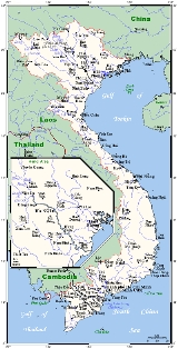
Vietnam – sometimes spelled Viet Nam , officially the Socialist Republic of Vietnam – is the easternmost country on the Indochina Peninsula in Southeast Asia. It is bordered by China to the north, Laos to the northwest, Cambodia to the southwest, and the South China Sea –...
is located on the eastern margin of the Indochinese peninsula
Indochina
The Indochinese peninsula, is a region in Southeast Asia. It lies roughly southwest of China, and east of India. The name has its origins in the French, Indochine, as a combination of the names of "China" and "India", and was adopted when French colonizers in Vietnam began expanding their territory...
and occupies about 331,688 square kilometers, of which about 25 % was under cultivation in 1987. It borders the Gulf of Thailand
Gulf of Thailand
The Gulf of Thailand , also known in to Malays as Teluk Siam literally meant Gulf of Siam, is a shallow arm of the South China Sea.-Geography:...
, Gulf of Tonkin
Gulf of Tonkin
The Gulf of Tonkin is an arm of the South China Sea, lying off the coast of northeastern Vietnam.-Etymology:The name Tonkin, written "東京" in Hán tự and Đông Kinh in romanised Vietnamese, means "Eastern Capital", and is the former toponym for Hanoi, the capital of Vietnam...
, and South China Sea
South China Sea
The South China Sea is a marginal sea that is part of the Pacific Ocean, encompassing an area from the Singapore and Malacca Straits to the Strait of Taiwan of around...
, alongside China
China
Chinese civilization may refer to:* China for more general discussion of the country.* Chinese culture* Greater China, the transnational community of ethnic Chinese.* History of China* Sinosphere, the area historically affected by Chinese culture...
, Laos
Laos
Laos Lao: ສາທາລະນະລັດ ປະຊາທິປະໄຕ ປະຊາຊົນລາວ Sathalanalat Paxathipatai Paxaxon Lao, officially the Lao People's Democratic Republic, is a landlocked country in Southeast Asia, bordered by Burma and China to the northwest, Vietnam to the east, Cambodia to the south and Thailand to the west...
, and Cambodia
Cambodia
Cambodia , officially known as the Kingdom of Cambodia, is a country located in the southern portion of the Indochina Peninsula in Southeast Asia...
. The S-shaped country has a north-to-south distance of 1,650 kilometers and is about 50 kilometers wide at the narrowest point. With a coastline of 3,260 kilometers, excluding islands, Vietnam claims 12 nmi (22.2 km; 13.8 mi) as the limit of its territorial waters, an additional 12 nmi (22.2 km; 13.8 mi) as a contiguous customs and security zone, and 200 nmi (370.4 km; 230.2 mi) as an exclusive economic zone.
The boundary with Laos, settled, on both an ethnic and geographical basis, between the rulers of Vietnam and Laos in the mid-seventeenth century with the Annamite Range
Annamite Range
The Annamite Range or the Annamese Mountains is a mountain range of eastern Indochina, which extends approximately through Laos, Vietnam, and a small area in northeast Cambodia. It is known in Vietnamese as Dãy Trường Sơn, in Lao as Xai Phou Luang , and in French as the Chaîne Annamitique...
as a reference, was formally defined by a delimitation treaty signed in 1977 and ratified in 1986. The frontier with Cambodia, defined at the time of French annexation of the western part of the Mekong River Delta in 1867, remained essentially unchanged, according to Hanoi
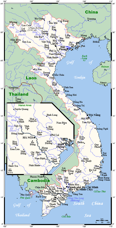
Hanoi
Hanoi , is the capital of Vietnam and the country's second largest city. Its population in 2009 was estimated at 2.6 million for urban districts, 6.5 million for the metropolitan jurisdiction. From 1010 until 1802, it was the most important political centre of Vietnam...
, until some unresolved border issues were finally settled in the 1982-85 period. The land and sea boundary with China, delineated under the France-China treaties of 1887 and 1895, is "the frontier line" accepted by Hanoi that China agreed in 1957- 58 to respect. However, in February 1979, following China's limited invasion of Vietnam, Hanoi complained that from 1957 onward China had provoked numerous border incidents as part of its anti-Vietnam policy and expansionist
Expansionism
In general, expansionism consists of expansionist policies of governments and states. While some have linked the term to promoting economic growth , more commonly expansionism refers to the doctrine of a state expanding its territorial base usually, though not necessarily, by means of military...
designs in Southeast Asia. Among the territorial infringements cited was the Chinese occupation in January 1974 of the Paracel Islands
Paracel Islands
The Paracel Islands, also called Xisha Islands in Chinese and Hoàng Sa Islands in Vietnamese, is a group of islands under the administration of Hainan Province, The People's Republic of China. Vietnam and the Republic of China also claim sovereignty of these islands...
, claimed by both countries in a dispute left unresolved in the 1980s.
Physiography
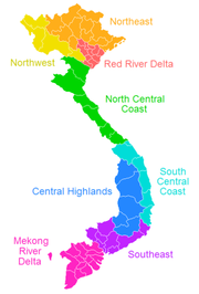
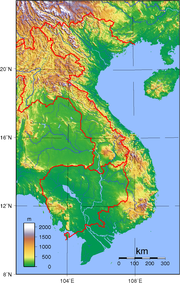
Vietnam is a country of tropical lowlands, hills, and densely forested highlands, with level land covering no more than 20% of the area. The country is divided into the highlands and the Red River deltaRed River (Vietnam)
The Red River , also known as the Sông Cái - Mother River , or Yuan River , is a river that flows from southwest China through northern Vietnam to the Gulf of Tonkin...
in the north; and the Giai Truong Son (Central mountains, or the Chaîne Annamitique, sometimes referred to simply as "the Chaine."), the coastal lowlands, and the Mekong River Delta in the south.
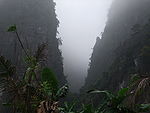
The spectacular Ban Gioc Waterfall is 272 km north of Hanoi and few tourists are seen there.
Red River Delta
The Red River Delta (also known as the Sông Hồng), is a flat, triangular region of 15,000 square kilometers, is smaller but more intensely developed and more densely populated than the Mekong River Delta. Once an inlet of the Gulf of TonkinGulf of Tonkin
The Gulf of Tonkin is an arm of the South China Sea, lying off the coast of northeastern Vietnam.-Etymology:The name Tonkin, written "東京" in Hán tự and Đông Kinh in romanised Vietnamese, means "Eastern Capital", and is the former toponym for Hanoi, the capital of Vietnam...
, it has been filled in by the enormous alluvial deposits
Alluvial fan
An alluvial fan is a fan-shaped deposit formed where a fast flowing stream flattens, slows, and spreads typically at the exit of a canyon onto a flatter plain. A convergence of neighboring alluvial fans into a single apron of deposits against a slope is called a bajada, or compound alluvial...
of the rivers over a period of millennia, and it advances one hundred meters into the Gulf annually. The ancestral home of the ethnic Vietnamese, the delta accounted for almost 70 % of the agriculture and 80 % of the industry of North Vietnam before 1975.
The Red River, rising in China's Yunnan province
Yunnan
Yunnan is a province of the People's Republic of China, located in the far southwest of the country spanning approximately and with a population of 45.7 million . The capital of the province is Kunming. The province borders Burma, Laos, and Vietnam.Yunnan is situated in a mountainous area, with...
, is about 1,200 kilometers long. Its two main tributaries, the Sông Lô (also called the Lo River, the Riviere Claire, or the Clear River) and the Sông Da
Black River (Vietnam)
The Black River is a river located in China and northwestern Vietnam. Its source is in Yunnan Province of China...
(also called the Black River or Riviere Noire), contribute to its high water volume, which averages 4,300 cubic meters per second.
The entire delta region, backed by the steep rises of the forested highlands, is no more than three meters above sea level, and much of it is one meter or less. The area is subject to frequent flooding; at some places the high-water mark of floods is fourteen meters above the surrounding countryside. For centuries flood control has been an integral part of the delta's culture and economy. An extensive system of dikes and canals has been built to contain the Red River and to irrigate the rich rice-growing delta. Modeled on that of China's, this ancient system has sustained a highly concentrated population and has made double-cropping wet-rice cultivation possible throughout about half the region.
Highlands
Tibet
Tibet is a plateau region in Asia, north-east of the Himalayas. It is the traditional homeland of the Tibetan people as well as some other ethnic groups such as Monpas, Qiang, and Lhobas, and is now also inhabited by considerable numbers of Han and Hui people...
an and Yunnan regions of southwest China and forms Vietnam's border with Laos and Cambodia. It terminates in the Mekong River Delta north of Hồ Chí Minh City
Ho Chi Minh City
Ho Chi Minh City , formerly named Saigon is the largest city in Vietnam...
(formerly Saigon).
These central mountains, which have several high plateaus, are irregular in elevation and form. The northern section is narrow and very rugged; the country's highest peak, Fan Si Pan, rises to 3,142 meters in the extreme northwest. The southern portion has numerous spurs that divide the narrow coastal strip into a series of compartments. For centuries these topographical features not only rendered north-south communication difficult but also formed an effective natural barrier for the containment of the people living in the Mekong basin.
Central Highlands
Within the southern portion of Vietnam is a plateau known as the Central Highlands (Tay NguyenTây Nguyên
Tây Nguyên, translated as Western Highlands and sometimes also called Central Highlands, is one of the regions of Vietnam. It contains the provinces of Đắk Lắk, Đắk Nông, Gia Lai, Kon Tum, Lâm Đồng....
), approximately 51,800 square kilometers of rugged mountain peaks, extensive forests, and rich soil. Comprising 5 relatively flat plateaus of basalt
Basalt
Basalt is a common extrusive volcanic rock. It is usually grey to black and fine-grained due to rapid cooling of lava at the surface of a planet. It may be porphyritic containing larger crystals in a fine matrix, or vesicular, or frothy scoria. Unweathered basalt is black or grey...
soil spread over the provinces of Đắk Lắk (or "Dac Lac"), Gia Lai, and Kon Tom
Kontum
Kon Tum is the capital town of Kon Tum province in Vietnam. It is located inland in the Central Highlands region of Vietnam, near the borders with Laos and Cambodia....
, the highlands account for 16% of the country's arable land
Arable land
In geography and agriculture, arable land is land that can be used for growing crops. It includes all land under temporary crops , temporary meadows for mowing or pasture, land under market and kitchen gardens and land temporarily fallow...
and 22% of its total forested land. Before 1975, North Vietnam
North Vietnam
The Democratic Republic of Vietnam , was a communist state that ruled the northern half of Vietnam from 1954 until 1976 following the Geneva Conference and laid claim to all of Vietnam from 1945 to 1954 during the First Indochina War, during which they controlled pockets of territory throughout...
had maintained that the Central Highlands and the Giai Truong Son were strategic areas of paramount importance, essential to the domination not only of South Vietnam but also of the southern part of Indochina. Since 1975, the highlands have provided an area in which to relocate people from the densely populated lowlands.
Coastal lowlands
The narrow, flat coastal lowlands extend from south of the Red River Delta to the Mekong River basin. On the landward side, the Giai Truong Son rises precipitously above the coast, its spurs jutting into the sea at several places. Generally the coastal strip is fertile and rice is cultivated intensively.Mekong River Delta
The Mekong river delta or Mekong delta, covering about 40,000 square kilometers, is a low-level plain not more than three meters above sea level at any point and criss-crossed by a maze of canals and rivers. So much sediment is carried by the Mekong's various branches and tributaries that the delta advances sixty to eighty meters into the sea every year. An official Vietnamese source estimates the amount of sediment deposited annually to be about 1 billion cubic meters, or nearly 13 times the amount deposited by the Red River. About 10,000 square kilometers of the delta are under rice cultivation, making the area one of the major rice-growing regions of the world. The southern tip, known as the Cà Mau PeninsulaCa Mau Province
Cà Mau is a province of Vietnam, named after its capital city. It is located in the Mekong Delta of southern Vietnam, and is the southernmost of Vietnam's 58 provinces...
is covered by dense jungle and mangrove
Mangrove
Mangroves are various kinds of trees up to medium height and shrubs that grow in saline coastal sediment habitats in the tropics and subtropics – mainly between latitudes N and S...
swamps.
The Mekong, which is 4,220 kilometers long, is one of the 12 great rivers of the world. From its source in the Tibetan plateau
Tibetan Plateau
The Tibetan Plateau , also known as the Qinghai–Tibetan Plateau is a vast, elevated plateau in Central Asia covering most of the Tibet Autonomous Region and Qinghai, in addition to smaller portions of western Sichuan, southwestern Gansu, and northern Yunnan in Western China and Ladakh in...
, it flows through the Tibetan and Yunnan regions of China, forms the boundary between Laos and Myanmar
Myanmar
Burma , officially the Republic of the Union of Myanmar , is a country in Southeast Asia. Burma is bordered by China on the northeast, Laos on the east, Thailand on the southeast, Bangladesh on the west, India on the northwest, the Bay of Bengal to the southwest, and the Andaman Sea on the south....
as well as between Laos and Thailand. At Phnom Penh
Phnom Penh
Phnom Penh is the capital and largest city of Cambodia. Located on the banks of the Mekong River, Phnom Penh has been the national capital since the French colonized Cambodia, and has grown to become the nation's center of economic and industrial activities, as well as the center of security,...
it merges with the Tonle Sap
Tonlé Sap
The Tonlé Sap is a combined lake and river system of major importance to Cambodia.The Tonlé Sap is the largest freshwater lake in South East Asia and is an ecological hot spot that was designated as a UNESCO biosphere in 1997....
and divides into two branches - the Song Hau Giang (known as the Bassac River
Bassac River
The Bassac River is a distributary of the Tonle Sap and Mekong River. The river starts in Phnom Penh, Cambodia, and flows southerly, crossing the border into Vietnam near Châu Đốc....
on the Cambodian side) and the Song Tien Giang - and continues through Cambodia and the Mekong basin before draining into the South China Sea
South China Sea
The South China Sea is a marginal sea that is part of the Pacific Ocean, encompassing an area from the Singapore and Malacca Straits to the Strait of Taiwan of around...
through nine mouths known as the cuu long (nine dragons). The river is heavily silted and is navigable by seagoing craft of shallow draft as far as Kompong Cham
Kampong Cham (city)
Kampong Cham is the capital city of the Kampong Cham Province in eastern Cambodia. It is the third largest city in Cambodia with a population of 63,771 people and is located on the Mekong River. Kampong Cham is 124 kilometers northeast from Phnom Penh and can be reached by either boat or by...
in Cambodia. A tributary entering the river at Phnom Penh drains the Tonlé Sap
Tonlé Sap
The Tonlé Sap is a combined lake and river system of major importance to Cambodia.The Tonlé Sap is the largest freshwater lake in South East Asia and is an ecological hot spot that was designated as a UNESCO biosphere in 1997....
, a shallow freshwater
Freshwater
Fresh water is naturally occurring water on the Earth's surface in ice sheets, ice caps, glaciers, bogs, ponds, lakes, rivers and streams, and underground as groundwater in aquifers and underground streams. Fresh water is generally characterized by having low concentrations of dissolved salts and...
lake that acts as a natural reservoir to stabilize the flow of water through the lower Mekong. When the river is in flood stage, its silt
Silt
Silt is granular material of a size somewhere between sand and clay whose mineral origin is quartz and feldspar. Silt may occur as a soil or as suspended sediment in a surface water body...
ed delta outlets are unable to carry off the high volume of water. Floodwaters back up into the Tonlé Sap, causing the lake to inundate as much as 10,000 square kilometers. As the flood subsides, the flow of water reverses and proceeds from the lake to the sea. The effect is to reduce significantly the danger of devastating floods in the Mekong delta, where the river floods the surrounding fields each year to a level of one to two meters.
Climate
Vietnam in the northern regions have a humid subtropical climateHumid subtropical climate
A humid subtropical climate is a climate zone characterized by hot, humid summers and mild to cool winters...
, with humidity
Humidity
Humidity is a term for the amount of water vapor in the air, and can refer to any one of several measurements of humidity. Formally, humid air is not "moist air" but a mixture of water vapor and other constituents of air, and humidity is defined in terms of the water content of this mixture,...
averaging 84% throughout the year. However, because of differences in latitude
Latitude
In geography, the latitude of a location on the Earth is the angular distance of that location south or north of the Equator. The latitude is an angle, and is usually measured in degrees . The equator has a latitude of 0°, the North pole has a latitude of 90° north , and the South pole has a...
and the marked variety of topographical relief, the climate tends to vary considerably from place to place. During the winter or dry season, extending roughly from November to April, the monsoon winds usually blow from the northeast along the China coast and across the Gulf of Tonkin
Gulf of Tonkin
The Gulf of Tonkin is an arm of the South China Sea, lying off the coast of northeastern Vietnam.-Etymology:The name Tonkin, written "東京" in Hán tự and Đông Kinh in romanised Vietnamese, means "Eastern Capital", and is the former toponym for Hanoi, the capital of Vietnam...
, picking up considerable moisture; consequently the winter season in most parts of the country is dry only by comparison with the rainy or summer season. During the southwesterly summer monsoon, occurring from May to October, the heated air of the Gobi Desert
Gobi Desert
The Gobi is a large desert region in Asia. It covers parts of northern and northwestern China, and of southern Mongolia. The desert basins of the Gobi are bounded by the Altai Mountains and the grasslands and steppes of Mongolia on the north, by the Hexi Corridor and Tibetan Plateau to the...
rises, far to the north, inducing moist air to flow inland from the sea and deposit heavy rainfall. The climate in the southern regions especially Ho Chi Minh City
Ho Chi Minh City
Ho Chi Minh City , formerly named Saigon is the largest city in Vietnam...
and surrounding Mekong Delta is predominantly Tropical savanna climate
Tropical savanna climate
Tropical savanna climate or tropical wet and dry climate is a type of climate that corresponds to the Köppen climate classification categories "Aw" and '"As."...
with high humidity and a distinct wet and dry season.
Annual rainfall is substantial in all regions and torrential in some, ranging from 1200 to 3000 mm (47.2 to 118.1 in). Nearly 90% of the precipitation occurs during the summer. The average annual temperature is generally higher in the plains than in the mountains and plateaus. Temperatures range from a low of 5 °C (41 °F) in December and January, the coolest months, to more than 37 °C (98.6 °F) in April, the hottest month. Seasonal divisions are more clearly marked in the northern half than in the southern half of the country, where, except in some of the highlands, seasonal temperatures vary only a few degrees, usually in the 21–28 °C (69.8–82.4 °F) range.
Area and boundaries
Area:- total: 329 560 km²
- land: 325 360 km²
- water: 4 200 km²
Area - comparative:
- slightly larger than the state of New MexicoNew MexicoNew Mexico is a state located in the southwest and western regions of the United States. New Mexico is also usually considered one of the Mountain States. With a population density of 16 per square mile, New Mexico is the sixth-most sparsely inhabited U.S...
in the United StatesUnited StatesThe United States of America is a federal constitutional republic comprising fifty states and a federal district...
. - slightly smaller than Newfoundland and LabradorNewfoundland and LabradorNewfoundland and Labrador is the easternmost province of Canada. Situated in the country's Atlantic region, it incorporates the island of Newfoundland and mainland Labrador with a combined area of . As of April 2011, the province's estimated population is 508,400...
, CanadaCanadaCanada is a North American country consisting of ten provinces and three territories. Located in the northern part of the continent, it extends from the Atlantic Ocean in the east to the Pacific Ocean in the west, and northward into the Arctic Ocean...
. - somewhat less than half as big as New South WalesNew South WalesNew South Wales is a state of :Australia, located in the east of the country. It is bordered by Queensland, Victoria and South Australia to the north, south and west respectively. To the east, the state is bordered by the Tasman Sea, which forms part of the Pacific Ocean. New South Wales...
, AustraliaAustraliaAustralia , officially the Commonwealth of Australia, is a country in the Southern Hemisphere comprising the mainland of the Australian continent, the island of Tasmania, and numerous smaller islands in the Indian and Pacific Oceans. It is the world's sixth-largest country by total area...
. - about 1⅓ times the United KingdomUnited KingdomThe United Kingdom of Great Britain and Northern IrelandIn the United Kingdom and Dependencies, other languages have been officially recognised as legitimate autochthonous languages under the European Charter for Regional or Minority Languages...
's size.
Land Boundaries:
- total: 4 639 km
- border countries: Cambodia (1 228 km), China (1 281 km), Laos (2 130 km)
Coastline: 3 444 km (excludes islands)
Maritime Claims:
- contiguous zone: 24 nmi (44.4 km; 27.6 mi)
- continental shelf: 200 nmi (370.4 km; 230.2 mi) or to the edge of the continental margin
- exclusive economic zone: 200 nmi (370.4 km; 230.2 mi)
- territorial sea: 12 nmi (22.2 km; 13.8 mi)
Elevation extremes:
- lowest point: South China Sea 0 m
- highest point: FansipanFansipanFansipan is a mountain in Vietnam, the highest in Indochina, at . It is located in the Lào Cai province of Northwest Vietnam, 9 km southwest of Sa Pa Township in the Hoang Lien Son mountain range....
3 143 m
Resources and land use
Natural resources: phosphates, coalCoal
Coal is a combustible black or brownish-black sedimentary rock usually occurring in rock strata in layers or veins called coal beds or coal seams. The harder forms, such as anthracite coal, can be regarded as metamorphic rock because of later exposure to elevated temperature and pressure...
, manganese
Manganese
Manganese is a chemical element, designated by the symbol Mn. It has the atomic number 25. It is found as a free element in nature , and in many minerals...
, bauxite
Bauxite
Bauxite is an aluminium ore and is the main source of aluminium. This form of rock consists mostly of the minerals gibbsite Al3, boehmite γ-AlO, and diaspore α-AlO, in a mixture with the two iron oxides goethite and hematite, the clay mineral kaolinite, and small amounts of anatase TiO2...
, chromate
Chromate
Chromate salts contain the chromate anion, CrO42−. Dichromate salts contain the dichromate anion, Cr2O72−. They are oxyanions of chromium in the oxidation state +6. They are moderately strong oxidizing agents.- Chemical properties :...
, offshore oil
Petroleum
Petroleum or crude oil is a naturally occurring, flammable liquid consisting of a complex mixture of hydrocarbons of various molecular weights and other liquid organic compounds, that are found in geologic formations beneath the Earth's surface. Petroleum is recovered mostly through oil drilling...
and gas
Gas
Gas is one of the three classical states of matter . Near absolute zero, a substance exists as a solid. As heat is added to this substance it melts into a liquid at its melting point , boils into a gas at its boiling point, and if heated high enough would enter a plasma state in which the electrons...
deposits, forest
Forest
A forest, also referred to as a wood or the woods, is an area with a high density of trees. As with cities, depending where you are in the world, what is considered a forest may vary significantly in size and have various classification according to how and what of the forest is composed...
s, hydropower
Hydropower
Hydropower, hydraulic power, hydrokinetic power or water power is power that is derived from the force or energy of falling water, which may be harnessed for useful purposes. Since ancient times, hydropower has been used for irrigation and the operation of various mechanical devices, such as...
- arable land: 17%
- permanent crops: 4%
- permanent pastures: 1%
- forests and woodland: 30%
- other: 48% (1993 est.)
Irrigated land: 18,600 km² (1993 est.)
Environmental concerns
Natural hazards: occasional typhoons (May to January) with extensive floodFlood
A flood is an overflow of an expanse of water that submerges land. The EU Floods directive defines a flood as a temporary covering by water of land not normally covered by water...
ing
Environment - current issues:
Logging
Logging
Logging is the cutting, skidding, on-site processing, and loading of trees or logs onto trucks.In forestry, the term logging is sometimes used in a narrow sense concerning the logistics of moving wood from the stump to somewhere outside the forest, usually a sawmill or a lumber yard...
and slash-and-burn agricultural practices contribute to deforestation
Deforestation
Deforestation is the removal of a forest or stand of trees where the land is thereafter converted to a nonforest use. Examples of deforestation include conversion of forestland to farms, ranches, or urban use....
and soil degradation; water pollution
Water pollution
Water pollution is the contamination of water bodies . Water pollution occurs when pollutants are discharged directly or indirectly into water bodies without adequate treatment to remove harmful compounds....
and overfishing
Overfishing
Overfishing occurs when fishing activities reduce fish stocks below an acceptable level. This can occur in any body of water from a pond to the oceans....
threaten marine life populations; groundwater contamination limits potable water
Drinking water
Drinking water or potable water is water pure enough to be consumed or used with low risk of immediate or long term harm. In most developed countries, the water supplied to households, commerce and industry is all of drinking water standard, even though only a very small proportion is actually...
supply; growing urbanization
Urbanization
Urbanization, urbanisation or urban drift is the physical growth of urban areas as a result of global change. The United Nations projected that half of the world's population would live in urban areas at the end of 2008....
and human migration
Human migration
Human migration is physical movement by humans from one area to another, sometimes over long distances or in large groups. Historically this movement was nomadic, often causing significant conflict with the indigenous population and their displacement or cultural assimilation. Only a few nomadic...
are rapidly degrading environment
Environment (biophysical)
The biophysical environment is the combined modeling of the physical environment and the biological life forms within the environment, and includes all variables, parameters as well as conditions and modes inside the Earth's biosphere. The biophysical environment can be divided into two categories:...
in Hanoi and Hồ Chí Minh City
Environment - international agreements:
party to: Biodiversity
Biodiversity
Biodiversity is the degree of variation of life forms within a given ecosystem, biome, or an entire planet. Biodiversity is a measure of the health of ecosystems. Biodiversity is in part a function of climate. In terrestrial habitats, tropical regions are typically rich whereas polar regions...
, Climate Change
United Nations Framework Convention on Climate Change
The United Nations Framework Convention on Climate Change is an international environmental treaty produced at the United Nations Conference on Environment and Development , informally known as the Earth Summit, held in Rio de Janeiro from June 3 to 14, 1992...
, Desertification
Desertification
Desertification is the degradation of land in drylands. Caused by a variety of factors, such as climate change and human activities, desertification is one of the most significant global environmental problems.-Definitions:...
, Endangered Species
Endangered species
An endangered species is a population of organisms which is at risk of becoming extinct because it is either few in numbers, or threatened by changing environmental or predation parameters...
, Environmental Modification, Hazardous Wastes, Law of the Sea
Law of the sea
Law of the sea may refer to:* United Nations Convention on the Law of the Sea* Admiralty law* The Custom of the Sea...
, Ozone Layer Protection, Ship Pollution (MARPOL 73/78
MARPOL 73/78
Marpol 73/78 is the International Convention for the Prevention of Pollution From Ships, 1973 as modified by the Protocol of 1978....
), Wetlands, Climate Change-Kyoto Protocol, Nuclear Test Ban
See also
- VietnamVietnamVietnam – sometimes spelled Viet Nam , officially the Socialist Republic of Vietnam – is the easternmost country on the Indochina Peninsula in Southeast Asia. It is bordered by China to the north, Laos to the northwest, Cambodia to the southwest, and the South China Sea –...
- Halong BayHalong BayHa Long Bay is a UNESCO World Heritage Site, and a popular travel destination, located in Quang Ninh province, Vietnam. Administratively, the bay belongs to Hạ Long City, Cẩm Phả town, and part of Van Don district. The bay features thousands of limestone karsts and isles in various sizes and shapes...
- List of endangered species in Vietnam
- Zomia (geography)Zomia (geography)Zomia is a geographical term coined in 2002 by historian Willem van Schendel of the University of Amsterdam to refer to the huge massif of mainland Southeast Asia that has historically been beyond the control of governments based in the population centers of the lowlands...