

Geography of Uganda
Encyclopedia

Uganda
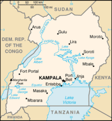
Uganda , officially the Republic of Uganda, is a landlocked country in East Africa. Uganda is also known as the "Pearl of Africa". It is bordered on the east by Kenya, on the north by South Sudan, on the west by the Democratic Republic of the Congo, on the southwest by Rwanda, and on the south by...
is located in Eastern Africa
Africa
Africa is the world's second largest and second most populous continent, after Asia. At about 30.2 million km² including adjacent islands, it covers 6% of the Earth's total surface area and 20.4% of the total land area...
, west of Kenya
Kenya
Kenya , officially known as the Republic of Kenya, is a country in East Africa that lies on the equator, with the Indian Ocean to its south-east...
, south of South Sudan
South Sudan
South Sudan , officially the Republic of South Sudan, is a landlocked country located in the Sahel region of northeastern Africa. It is also part of the North Africa UN sub-region. Its current capital is Juba, which is also its largest city; the capital city is planned to be moved to the more...
and east of the Democratic Republic of the Congo
Democratic Republic of the Congo
The Democratic Republic of the Congo is a state located in Central Africa. It is the second largest country in Africa by area and the eleventh largest in the world...
. It is in the heart of the Great Lakes region, and is surrounded by three of them, Lake Edward
Lake Edward
Lake Edward or Edward Nyanza is the smallest of the African Great Lakes. It is located in the western Great Rift Valley, on the border between the Democratic Republic of the Congo and Uganda, with its northern shore a few kilometres south of the Equator...
, Lake Albert, and Lake Victoria
Lake Victoria
Lake Victoria is one of the African Great Lakes. The lake was named for Queen Victoria of the United Kingdom, by John Hanning Speke, the first European to discover this lake....
. While much of its border is lakeshore, Uganda is landlocked
Landlocked
A landlocked country is a country entirely enclosed by land, or whose only coastlines lie on closed seas. There are 48 landlocked countries in the world, including partially recognized states...
with no access to the sea.
Despite being on the equator
Equator
An equator is the intersection of a sphere's surface with the plane perpendicular to the sphere's axis of rotation and containing the sphere's center of mass....
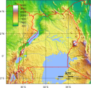
Uganda is more temperate than the surrounding areas due to its altitude.
The country is mostly plateau with a rim of mountains. This has made it more suitable to agriculture and less prone to tropical diseases than other nations in the region. The climate is tropical; generally rainy with two dry seasons (December to February, June to August). It is semiarid East Sudanian savanna
East Sudanian savanna
The East Sudanian Savanna is a hot, dry, tropical savanna ecoregion of central Africa.-Location and description:This is the eastern half of the broad savanna belt which runs east and west across Africa, this section lying east of the Cameroon Highlands...
in north near Sudan
Sudan
Sudan , officially the Republic of the Sudan , is a country in North Africa, sometimes considered part of the Middle East politically. It is bordered by Egypt to the north, the Red Sea to the northeast, Eritrea and Ethiopia to the east, South Sudan to the south, the Central African Republic to the...
.
Geographic coordinates: 1°00′N 32°00′E
Climate
Uganda's climate is tropical. This means it is generally rainy (particularly during the months of March to May, September to November), while the remaining months (December to February, June to August) comprise Uganda's two dry seasons.Statistics
Area:total:
236 040 km²
land:199 710 km²
water:
36 330 km²
Land boundaries:
total:
2 698 km
border countries:
Democratic Republic of the Congo
Democratic Republic of the Congo
The Democratic Republic of the Congo is a state located in Central Africa. It is the second largest country in Africa by area and the eleventh largest in the world...
765 km, Kenya
Kenya
Kenya , officially known as the Republic of Kenya, is a country in East Africa that lies on the equator, with the Indian Ocean to its south-east...
933 km, Rwanda
Rwanda
Rwanda or , officially the Republic of Rwanda , is a country in central and eastern Africa with a population of approximately 11.4 million . Rwanda is located a few degrees south of the Equator, and is bordered by Uganda, Tanzania, Burundi and the Democratic Republic of the Congo...
169 km, South Sudan
South Sudan
South Sudan , officially the Republic of South Sudan, is a landlocked country located in the Sahel region of northeastern Africa. It is also part of the North Africa UN sub-region. Its current capital is Juba, which is also its largest city; the capital city is planned to be moved to the more...
435 km, Tanzania
Tanzania
The United Republic of Tanzania is a country in East Africa bordered by Kenya and Uganda to the north, Rwanda, Burundi, and the Democratic Republic of the Congo to the west, and Zambia, Malawi, and Mozambique to the south. The country's eastern borders lie on the Indian Ocean.Tanzania is a state...
396 km
Elevation extremes:
highest point:
Margherita Peak on Mount Stanley
Mount Stanley
Mount Stanley is a mountain located in the Rwenzori range. With an elevation of 5,109 m , it is the highest mountain of both the Democratic Republic of the Congo and Uganda, and the third highest in Africa, after Kilimanjaro and Mount Kenya . The peak and several other surrounding peaks are high...
5 110 m
Natural resources:
copper
Copper
Copper is a chemical element with the symbol Cu and atomic number 29. It is a ductile metal with very high thermal and electrical conductivity. Pure copper is soft and malleable; an exposed surface has a reddish-orange tarnish...
, cobalt
Cobalt
Cobalt is a chemical element with symbol Co and atomic number 27. It is found naturally only in chemically combined form. The free element, produced by reductive smelting, is a hard, lustrous, silver-gray metal....
, hydropower
Hydropower
Hydropower, hydraulic power, hydrokinetic power or water power is power that is derived from the force or energy of falling water, which may be harnessed for useful purposes. Since ancient times, hydropower has been used for irrigation and the operation of various mechanical devices, such as...
, limestone
Limestone
Limestone is a sedimentary rock composed largely of the minerals calcite and aragonite, which are different crystal forms of calcium carbonate . Many limestones are composed from skeletal fragments of marine organisms such as coral or foraminifera....
, salt
Salt
In chemistry, salts are ionic compounds that result from the neutralization reaction of an acid and a base. They are composed of cations and anions so that the product is electrically neutral...
, arable land
Land use:
arable land:
25%
permanent crops:
9%
permanent pastures:
9%
forests and woodland:
28%
other:
29% (1993 est.)
Irrigated land:
90 km² (1993 est.)
Environment - current issues:
draining of wetlands for agricultural use; deforestation
Deforestation
Deforestation is the removal of a forest or stand of trees where the land is thereafter converted to a nonforest use. Examples of deforestation include conversion of forestland to farms, ranches, or urban use....
; overgrazing
Overgrazing
Overgrazing occurs when plants are exposed to intensive grazing for extended periods of time, or without sufficient recovery periods. It can be caused by either livestock in poorly managed agricultural applications, or by overpopulations of native or non-native wild animals.Overgrazing reduces the...
; soil erosion
Erosion
Erosion is when materials are removed from the surface and changed into something else. It only works by hydraulic actions and transport of solids in the natural environment, and leads to the deposition of these materials elsewhere...
; poaching is widespread
Environment - international agreements:
party to:
Biodiversity
Biodiversity
Biodiversity is the degree of variation of life forms within a given ecosystem, biome, or an entire planet. Biodiversity is a measure of the health of ecosystems. Biodiversity is in part a function of climate. In terrestrial habitats, tropical regions are typically rich whereas polar regions...
, Climate Change
United Nations Framework Convention on Climate Change
The United Nations Framework Convention on Climate Change is an international environmental treaty produced at the United Nations Conference on Environment and Development , informally known as the Earth Summit, held in Rio de Janeiro from June 3 to 14, 1992...
, Desertification
Desertification
Desertification is the degradation of land in drylands. Caused by a variety of factors, such as climate change and human activities, desertification is one of the most significant global environmental problems.-Definitions:...
, Endangered Species
Endangered species
An endangered species is a population of organisms which is at risk of becoming extinct because it is either few in numbers, or threatened by changing environmental or predation parameters...
, Hazardous Wastes, Law of the Sea
Law of the sea
Law of the sea may refer to:* United Nations Convention on the Law of the Sea* Admiralty law* The Custom of the Sea...
, Marine Life Conservation, Nuclear Test Ban, Ozone Layer Protection, Wetlands
signed, but not ratified:
Environmental Modification
Extreme points
This is a list of the extreme points of UgandaUganda
Uganda , officially the Republic of Uganda, is a landlocked country in East Africa. Uganda is also known as the "Pearl of Africa". It is bordered on the east by Kenya, on the north by South Sudan, on the west by the Democratic Republic of the Congo, on the southwest by Rwanda, and on the south by...
, the points that are farther north, south, east or west than any other location.
- Northern-most point - the tripointTripointA tripoint, or trijunction , is a geographical point at which the borders of three countries or subnational entities meet....
with KenyaKenyaKenya , officially known as the Republic of Kenya, is a country in East Africa that lies on the equator, with the Indian Ocean to its south-east...
and SudanSudanSudan , officially the Republic of the Sudan , is a country in North Africa, sometimes considered part of the Middle East politically. It is bordered by Egypt to the north, the Red Sea to the northeast, Eritrea and Ethiopia to the east, South Sudan to the south, the Central African Republic to the...
, Kotido DistrictKotido DistrictKotido District is a district in Northern Uganda. It is named after its 'chief town', Kotido, where the district headquarters are located.-Location:... - Eastern-most point - unnamed location on the border with KenyaKenyaKenya , officially known as the Republic of Kenya, is a country in East Africa that lies on the equator, with the Indian Ocean to its south-east...
, Nakapiripirit DistrictNakapiripirit DistrictNakapiripirit District is a district in Northern Uganda. Like many other Ugandan districts, it is named after its 'chief town', Nakapiripirit, where the district headquarters are located.-Location:... - Southern-most point - unnamed location on the border with RwandaRwandaRwanda or , officially the Republic of Rwanda , is a country in central and eastern Africa with a population of approximately 11.4 million . Rwanda is located a few degrees south of the Equator, and is bordered by Uganda, Tanzania, Burundi and the Democratic Republic of the Congo...
immediately south of Lake BunyonyiLake BunyonyiLake Bunyonyi lies in south western Uganda between Kisoro and Kabale close to the border with Rwanda. Located at 1,962 m above sea level, it is about 25 km long and 7 km wide. The depth of the lake is rumored to vary between 44 m and 900 m, which if true would make the lake the second...
, Kabale DistrictKabale DistrictKabale District is a district in Western Uganda. As with most other Ugandan districts, it is named after its 'chief town', Kabale. It was originally part of the district of Kigezi, before the districts of Rukungiri, Kanungu and Kisoro were peeled off to form separate districts.-Location:Kabale... - Western-most point - unnamed location on the border with the Democratic Republic of the CongoDemocratic Republic of the CongoThe Democratic Republic of the Congo is a state located in Central Africa. It is the second largest country in Africa by area and the eleventh largest in the world...
immediately east of the Congolese village of Kirambo, Kisoro DistrictKisoro DistrictKisoro District is a district in Western Uganda. Like most other Ugandan districts, it is named after its 'chief town', Kisoro, where the district headquarters are located.-Location:...