

Geography of Thailand
Encyclopedia
Thailand
Thailand , officially the Kingdom of Thailand , formerly known as Siam , is a country located at the centre of the Indochina peninsula and Southeast Asia. It is bordered to the north by Burma and Laos, to the east by Laos and Cambodia, to the south by the Gulf of Thailand and Malaysia, and to the...
's 514,000 square kilometers lie in the middle of mainland Southeast Asia
Southeast Asia
Southeast Asia, South-East Asia, South East Asia or Southeastern Asia is a subregion of Asia, consisting of the countries that are geographically south of China, east of India, west of New Guinea and north of Australia. The region lies on the intersection of geological plates, with heavy seismic...
. The nation's axial position influenced many aspects of Thailand's society and culture—it controls the only land route from Asia
Asia
Asia is the world's largest and most populous continent, located primarily in the eastern and northern hemispheres. It covers 8.7% of the Earth's total surface area and with approximately 3.879 billion people, it hosts 60% of the world's current human population...
to Malaysia and Singapore
Singapore
Singapore , officially the Republic of Singapore, is a Southeast Asian city-state off the southern tip of the Malay Peninsula, north of the equator. An island country made up of 63 islands, it is separated from Malaysia by the Straits of Johor to its north and from Indonesia's Riau Islands by the...
.
Geographic coordinates
The fertile floodplain and tropical monsoon climate, ideally suited to wet-rice (tham na) cultivation, attracted settlers to this central area over to the marginal uplands and mountains of the northern region or the Khorat PlateauKhorat Plateau
The Khorat Plateau also Korat Plateau, is a plateau in the northeastern region of Thailand, named for the short form of Nakhon Ratchasima, an historical stronghold controlling access to and from the plateau.-Geography:...
to the northeast.
By the 12th century AD, a number of loosely connected rice-growing and trading states flourished in the upper Chao Phraya Valley. They broke free from domination of the Khmer Empire
Khmer Empire
The Khmer Empire was one of the most powerful empires in Southeast Asia. The empire, which grew out of the former kingdom of Chenla, at times ruled over and/or vassalized parts of modern-day Laos, Thailand, Vietnam, Burma, and Malaysia. Its greatest legacy is Angkor, the site of the capital city...
, but from the middle of the 14th century gradually came under the control of the Ayutthaya kingdom
Ayutthaya kingdom
Ayutthaya was a Siamese kingdom that existed from 1350 to 1767. Ayutthaya was friendly towards foreign traders, including the Chinese, Vietnamese , Indians, Japanese and Persians, and later the Portuguese, Spanish, Dutch and French, permitting them to set up villages outside the walls of the...
at the southern extremity of the floodplain.
Successive capitals, built at various points along the river, became centers of great Thai kingdoms based on rice cultivation and foreign commerce. Unlike the neighboring Khmer
Khmer people
Khmer people are the predominant ethnic group in Cambodia, accounting for approximately 90% of the 14.8 million people in the country. They speak the Khmer language, which is part of the larger Mon–Khmer language family found throughout Southeast Asia...
and Burmese
Bamar
The Bamar are the dominant ethnic group of Burma , constituting approximately two-thirds of the population. The Bamar live primarily in the Irrawaddy basin, and speak the Burmese language, which is also the official language of Burma. Bamar customs and identity are closely intertwined with general...
, the Thai continued to look outward across the Gulf of Thailand
Gulf of Thailand
The Gulf of Thailand , also known in to Malays as Teluk Siam literally meant Gulf of Siam, is a shallow arm of the South China Sea.-Geography:...
and the Andaman Sea
Andaman Sea
The Andaman Sea or Burma Sea is a body of water to the southeast of the Bay of Bengal, south of Burma, west of Thailand and east of the Andaman Islands, India; it is part of the Indian Ocean....
toward foreign ports of trade.
When European imperialism brought a new phase in Southeast Asian commerce in the late 1800s, Thailand
Thailand
Thailand , officially the Kingdom of Thailand , formerly known as Siam , is a country located at the centre of the Indochina peninsula and Southeast Asia. It is bordered to the north by Burma and Laos, to the east by Laos and Cambodia, to the south by the Gulf of Thailand and Malaysia, and to the...
(known then as Siam) was able to maintain its independence as a buffer zone between British-controlled Burma to the west and French-dominated Indochina
Indochina
The Indochinese peninsula, is a region in Southeast Asia. It lies roughly southwest of China, and east of India. The name has its origins in the French, Indochine, as a combination of the names of "China" and "India", and was adopted when French colonizers in Vietnam began expanding their territory...
to the east, but losing over 50% of its territory in the process. Fortunately, most of the areas lost contained a non-Thai population (Khmer, Lao
Lao
Lao or Laotian may refer to:* Something of, from, or related to Laos, a country in Southeast Asia* Lao people * The Lao language* Lao script, the writing system used to write the Lao language* Lao cuisine...
or Shan
Shan
The Shan are a Tai ethnic group of Southeast Asia. The Shan live primarily in the Shan State of Burma , but also inhabit parts of Mandalay Division, Kachin State, and Kayin State, and in adjacent regions of China and Thailand...
). The Thai-speaking heartland remains intact.
Land boundaries
- Total: 4,863 km
- Border countries: MyanmarMyanmarBurma , officially the Republic of the Union of Myanmar , is a country in Southeast Asia. Burma is bordered by China on the northeast, Laos on the east, Thailand on the southeast, Bangladesh on the west, India on the northwest, the Bay of Bengal to the southwest, and the Andaman Sea on the south....
1,800 km, CambodiaCambodiaCambodia , officially known as the Kingdom of Cambodia, is a country located in the southern portion of the Indochina Peninsula in Southeast Asia...
803 km, LaosLaosLaos Lao: ສາທາລະນະລັດ ປະຊາທິປະໄຕ ປະຊາຊົນລາວ Sathalanalat Paxathipatai Paxaxon Lao, officially the Lao People's Democratic Republic, is a landlocked country in Southeast Asia, bordered by Burma and China to the northwest, Vietnam to the east, Cambodia to the south and Thailand to the west...
1,754 km, Malaysia 506 km
Maritime claims
- territorial sea: 12 nmi (22.2 km)
- exclusive economic zone: 200 nmi (370.4 km)
- continental shelf: 20-m depth or to the depth of exploitation
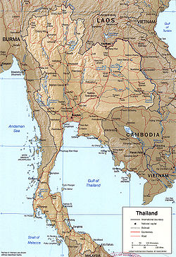
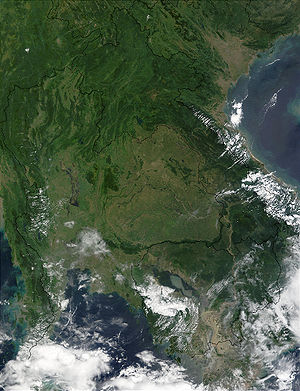
Topography and drainage
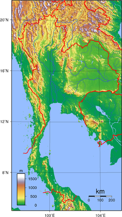
The most conspicuous features of Thailand's terrain are high mountains
Thai highlands
The Thai Highlands are mountains in the north of Thailand that are part of the range of hills extending through Laos, Burma and China and linking to the Himalayas, of which they may be considered foothills.-Geography:...
, a central plain, and an upland plateau. Mountains cover much of northern Thailand and extend along the Myanmar border down through the Kra Isthmus
Kra Isthmus
The Kra Isthmus is the narrow land bridge which connects the Malay Peninsula with the mainland of Asia, and popularly named "The Devil's Neck".-Geography:...
and the Malay Peninsula
Malay Peninsula
The Malay Peninsula or Thai-Malay Peninsula is a peninsula in Southeast Asia. The land mass runs approximately north-south and, at its terminus, is the southern-most point of the Asian mainland...
. The central plain is a lowland area drained by the Chao Phraya River
Chao Phraya River
The Chao Phraya is a major river in Thailand, with its low alluvial plain forming the centre of the country. It runs through Bangkok, the capital city, and then empties into the Gulf of Thailand.-Etymology:...
and its tributaries
Tributaries of the Chao Phraya River
The principal tributaries of the Chao Phraya River of Thailand are the Pa Sak River, the Sakae Krang River, the Nan River , the Ping River , and the Tha Chin River...
, the country's principal river system, which feeds into the delta at the head of the Bay of Bangkok
Bay of Bangkok
The Bay of Bangkok , also known as the Bight of Bangkok, is the northernmost part of the Gulf of Thailand, roughly extending from Hua Hin to the west and Sattahip to the east...
. The Chao Phraya system drains about one-third of the nation's territory. In the northeastern part of the country the Khorat Plateau
Khorat Plateau
The Khorat Plateau also Korat Plateau, is a plateau in the northeastern region of Thailand, named for the short form of Nakhon Ratchasima, an historical stronghold controlling access to and from the plateau.-Geography:...
, a region of gently rolling low hills and shallow lakes, drains into the Mekong through the Mun River
Mun River
The Mun River , sometimes spelled Moon River, is a tributary of the Mekong river. It carries approximately 21,000 cubic kilometres of water per year.-Geography:...
. The Mekong system empties into the South China Sea
South China Sea
The South China Sea is a marginal sea that is part of the Pacific Ocean, encompassing an area from the Singapore and Malacca Straits to the Strait of Taiwan of around...
and includes a series of canals and dams.
Together, the Chao Phraya and Mekong systems sustain Thailand's agricultural economy
Agriculture in Thailand
Thai agriculture is highly competitive, diversified and specialised and its exports are very successful internationally. Rice is the country's most important crop; Thailand is a major exporter in the world rice market. Other agricultural commodities produced in significant amounts include fish and...
by supporting wet-rice cultivation and providing waterways for the transport of goods and people. In contrast, the distinguishing natural features of peninsular Thailand are long coastlines, offshore islands, and diminishing mangrove swamps.
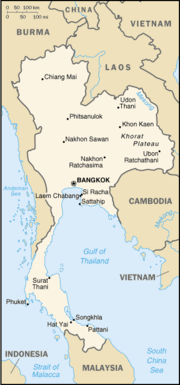
Area
- Total: 514 000 km²
- Land: 511 770 km²
- Water: 2 230 km²
Thailand uses a unit of land area called the Rai (unit), which is 1600 square metre (0.395368260824442 acre).
Extreme points
- Northernmost point: Myanmar border, Mae Sai District, Chiang Rai ProvinceChiang Rai ProvinceChiang Rai is the northernmost province of Thailand. Neighbouring provinces are Phayao, Lampang and Chiang Mai. In the north it borders Shan State of Myanmar and Bokeo of Laos.-Geography:...
, at 20°28′N 99°57′E - Southernmost point: Malaysian border, Betong DistrictAmphoe BetongBetong is the southernmost district of Yala Province, southern Thailand.-Geography:Betong is located at the boundary to Malaysia. To the north is Than To, to the east Chanae . To the south is the Malayian state of Perak, to the west Kedah.-History:In the past time, this area was under Mueang...
, Yala ProvinceYala ProvinceYala is the southernmost province of Thailand. Neighboring provinces are Songkhla, Pattani and Narathiwat. Yala is the only land-locked province in the south of Thailand...
, at 5°37′N 101°8′E - Easternmost point: Laos border, Khong Chiam DistrictAmphoe Khong ChiamKhong Chiam is the easternmost district of Ubon Ratchathani Province of Thailand.-History:The area of the district was the central district Khwaeng of Mueang Khong Chiam, which is now Si Mueang Mai district...
, Ubon Ratchathani ProvinceUbon Ratchathani Province-History:The area was part of the Khmer Empire. Before the late eighteenth century, this area evidently was outside Siamese or Thai Ayutthaya Kingdom....
, at 15°38′N 105°38′E - Westernmost point: Myanmar border, Mae Sariang District, Mae Hong Son ProvinceMae Hong Son ProvinceMost of the areas of Mae Hong Son Province are complex mountain ranges and likely still pristine virgin forest. Of the approximately 6,976,650 rai of national forest reserves, 88.02% is thought to be pristine virgin forest...
, at 18°34′N 97°21′E
Elevation extremes
- Highest point: Doi InthanonDoi InthanonDoi Inthanon ) is the highest mountain in Thailand. It is located in Mae Chaem District. The mountain was also known in the past as Doi Luang or Doi Ang Ka, meaning the crow's pond top. Near the mountain's base was a pond where many crows gathered...
, 2,565 m, at 18°35′32"N 98°29′12"E - Lowest point: Gulf of ThailandGulf of ThailandThe Gulf of Thailand , also known in to Malays as Teluk Siam literally meant Gulf of Siam, is a shallow arm of the South China Sea.-Geography:...
, 0 m
Regions
The National Research Council divides Thailand into six geographical regions, based on natural features including landforms and drainage, as well as human cultural patterns. They are, namely: the North Region, the Northeast Region, the Central Region, the East Region, the West Region and the South Region of Thailand. Although Bangkok geographically is part of the central plain, as the capital and largest city this metropolitan area may be considered in other respects a separate region. Each of the six geographical regions differs from the others in population, basic resources, natural features, and level of social and economic development. The diversity of the regions is in fact the most pronounced attribute of Thailand's physical setting.Northern Thailand
During the winter months in mountainous Northern ThailandNorthern Thailand
Thailand's northern region is geographically characterised by multiple mountain ranges which continue from the Shan Hills in bordering Myanmar and Laos, and the river valleys which cut through them...
, the temperature is cool enough for the cultivation of fruits such as lychee
Lychee
The lychee is the sole member of the genus Litchi in the soapberry family, Sapindaceae. It is a tropical and subtropical fruit tree native to Southern China and Southeast Asia, and now cultivated in many parts of the world...
s and strawberries
Strawberry
Fragaria is a genus of flowering plants in the rose family, Rosaceae, commonly known as strawberries for their edible fruits. Although it is commonly thought that strawberries get their name from straw being used as a mulch in cultivating the plants, the etymology of the word is uncertain. There...
. These high mountains are incised by steep river valleys and upland areas that border the central plain. A series of rivers, including the Nan
Nan River
The Nan River is a river in Thailand. It is one of the most important tributaries of the Chao Phraya River.-Geography:The Nan River originates in Nan Province. The provinces along the river after Nan Province are Uttaradit, Phitsanulok and Phichit. The Yom River joins the Nan River at Chum Saeng...
, Ping
Ping River
The Ping River , along with the Nan River, is one of the two main contributaries of Chao Phraya River. It originates at Doi Chiang Dao in Chiang Dao district, Chiang Mai Province. After passing Chiang Mai town, it flows though the provinces Lamphun, Tak, and Kamphaeng Phet...
, Wang
Wang River
The Wang River is a river in northern Thailand.-Geography:The Wang River is altogether 335nsnp;km long. Its waters flow from north to south. One of the principal settlements along the river is Lampang, which is situated on the north bank of a curve in the river. From Lampang, the river extends...
, and Yom
Yom River
The Yom River is the dime main tributary of the Nan River . The Yom originates in Pong district, Phayao Province, Thailand...
, unite in the lowlands to form the Chao Phraya Watershed
Chao Phraya River
The Chao Phraya is a major river in Thailand, with its low alluvial plain forming the centre of the country. It runs through Bangkok, the capital city, and then empties into the Gulf of Thailand.-Etymology:...
. Traditionally, these natural features made possible several different types of agriculture, including wet-rice farming in the valleys and shifting cultivation in the uplands. The forested mountains also promoted a spirit of regional independence. Forests, including stands of teak and other economically useful hardwoods that once dominated the North and parts of the Northeast, had diminished by the 1980s to 130,000 km². In 1961 they covered 56 % of the country, but by the mid-1980s forestland had been reduced to less than 30 % of Thailand's total area.
Northeastern Thailand
The Northeast, with its poor soils, is not favoured agriculturally. However, sticky rice, the staple food of the region, which requires flooded, poorly drained paddy fields, thrives and where fields can be flooded from nearby streams, rivers and ponds, often two harvests are possible each year. Cash crops such as sugar cane and manioc are cultivated on a vast scale, and to a lesser extent, rubber. Silk production is an important cottage industry and contributes significantly to the economy.The region consists mainly of the dry Khorat Plateau
Khorat Plateau
The Khorat Plateau also Korat Plateau, is a plateau in the northeastern region of Thailand, named for the short form of Nakhon Ratchasima, an historical stronghold controlling access to and from the plateau.-Geography:...
which in some parts is extremely flat, and a few low but rugged and rocky hills. The short monsoon season brings heavy flooding in the river valleys. Unlike the more fertile areas of Thailand, the Northeast has a long dry season, and much of the land is covered by sparse grasses. Mountains ring the plateau on the west and the south, and the Mekong delineates much of the northern and eastern rim. Some varieties of traditional medicinal herbs, particularly of the Genus Curcuma, family Zingiberaceae, are indigenous to the region.
Central Thailand
The "heartland", Central ThailandCentral Thailand
Central Thailand is a region of Thailand, covering the broad alluvial plain of the Chao Phraya River. It is separated from North-East Thailand by the Phetchabun mountain range, and another mountain range separates it from Myanmar to the west. In the north it gently changes into the more hilly...
, is a natural self-contained basin often termed "the rice bowl of Asia." The complex irrigation system developed for wet-rice agriculture in this region provided the necessary economic support to sustain the development of the Thai state from the 13th century Sukhothai kingdom
Sukhothai kingdom
The Sukhothai Kingdom ) was an early kingdom in the area around the city Sukhothai, in north central Thailand. The Kingdom existed from 1238 till 1438...
to contemporary Bangkok. Here the rather flat unchanging landscape facilitated inland water and road transport. The fertile area was able to sustain a dense population, 422 persons per square kilometer in 1987, compared with an average of 98 for the country as a whole. The terrain of the region is dominated by the Chao Phraya and its tributaries and by the cultivated paddy fields. Metropolitan Bangkok, the focal point of trade, transport, and industrial activity, is situated on the southern edge of the region at the head of the Gulf of Thailand and includes part of the delta of the Chao Phraya BTS
Eastern Thailand
Eastern ThailandEastern Thailand
Eastern Thailand is a region of Thailand bordering Cambodia on the east and Central Thailand on the west.-Geography:Eastern Thailand lies between the Sankamphaeng Range, which forms the border of the Northeastern plateau to the north and the Gulf of Thailand to the south...
lies between the Sankamphaeng Range, which forms the border of the Northeastern plateau to the north and the Gulf of Thailand to the south. The geography of the region is characterised by short mountain ranges alternating with small basins of short rivers which drain into the Gulf of Thailand.
Fruit is a major component of agriculture in the area, and tourism plays a strong part in the economy. The region's coastal location has helped promote the Eastern Seaboard industrial development, a major factor in the economy of the region.
Western Thailand
Thailand's long mountainous border with Myanmar continues south from the North into Western ThailandWestern Thailand
Western Thailand is a region of Thailand bordering Myanmar on the west and Central Thailand on the east.-Geography:Thailand's long mountainous border with Myanmar continues south from Northern Thailand into Western Thailand following the Tenasserim Hills...
with the Tenasserim Hills
Tenasserim Hills
Tenasserim Hills or Tenasserim Range is the geographical name of a mountain chain in Southeast Asia. Despite their relatively scant altitude these mountains form an effective barrier between Thailand and Burma in their northern and central region, extending to the Kra Isthmus into the Malay...
. The geography of the western region of Thailand, like the North, is characterised by high mountains and steep river valleys.
Western Thailand hosts much of Thailand's less-disturbed forest areas. Water and minerals are also important natural resources; the region is home to many of the country's major dams, and mining is an important industry in the area.
Southern Thailand
Southern ThailandSouthern Thailand
Southern Thailand is a distinct region of Thailand, connected with the Central region by the narrow Kra Isthmus.-Geography:Southern Thailand is located on the Malay Peninsula, with an area around 70,713 km², bounded to the north by Kra Isthmus as the narrowest part of the peninsula. The...
, part of a narrow peninsula, is distinctive in climate, terrain, and resources. Its economy is based on rice cultivation for subsistence and rubber production for industry. Other sources of income include coconut plantations, tin mining, and tourism, which is particularly lucrative on Phuket
Phuket Province
Phuket , formerly known as Thalang and, in Western sources, Junk Ceylon , is one of the southern provinces of Thailand...
Island. Rolling and mountainous terrain and the absence of large rivers are conspicuous features of the South. North-south mountain barriers and impenetrable tropical forest caused the early isolation and separate political development of this region. International access through the Andaman Sea
Andaman Sea
The Andaman Sea or Burma Sea is a body of water to the southeast of the Bay of Bengal, south of Burma, west of Thailand and east of the Andaman Islands, India; it is part of the Indian Ocean....
and the Gulf of Thailand made the South a crossroads for both Theravada Buddhism, centered at Nakhon Si Thammarat
Nakhon Si Thammarat
Nakhon Si Thammarat is a town in southern Thailand, capital of the Nakhon Si Thammarat Province and the Nakhon Si Thammarat district. It is about south of Bangkok, on the east coast of the Malay Peninsula. The city was the administrative center of southern Thailand during most of its history. ...
, and Islam
Islam
Islam . The most common are and . : Arabic pronunciation varies regionally. The first vowel ranges from ~~. The second vowel ranges from ~~~...
, especially in the former Pattani kingdom
Pattani kingdom
Pattani or Sultanate of Pattani was a Malay sultanate that covered approximately the area of the modern Thai provinces of Pattani, Yala, Narathiwat and much of the northern part of modern Malaysia. The King of Patani is believed to have converted to Islam some time during the 11th century...
on the border with Malaysia.
Provinces
Thailand's regions are further politically divided into a total of 77 provinces,such as Ratchaburi,Petchaburi etc. plus Bangkok, which is a special administrative area. The country's provinces have the same names as their respective capitals.Climate
Köppen climate classification
The Köppen climate classification is one of the most widely used climate classification systems. It was first published by Crimea German climatologist Wladimir Köppen in 1884, with several later modifications by Köppen himself, notably in 1918 and 1936...
, while the South and the eastern tip of the East have a tropical monsoon climate (Am); countrywide, temperatures normally range from an average annual high of 38 °C (100.4 °F) to a low of 19 °C (66.2 °F). During the dry season, the temperature rises dramatically in the second half of March, spiking to well over 40 °C (104 °F) in some areas by mid April when the Sun passes the Zenith. Southwest monsoons that arrive between May and July (except in the South) signal the advent of the rainy season (ruedu fon), which lasts into October and the cloud covering reduces the temperature again but the high humidity is experienced as 'hot and sticky'. November and December mark the onset of the dry season and night temperatures on high ground can occasionally drop to a light frost. Temperatures begin to climb in January, and a hot sun parches the landscape. The dry season is shortest in the South because of the proximity of the sea to all parts of the Malay Peninsula. With only minor exceptions, every area of the country receives adequate rainfall, but the duration of the rainy season and the amount of rain vary substantially from region to region and with altitude. The Northeast experiences a long dry season although the dry 2007/2008 season lasted only from late November through mid March. Its red,(laterite) dense clayey soils retain water well, which limits their agricultural potential for many crops but is ideal for keeping the water in the paddy fields and local village reservoirs. The well drained, loose sandy alluvium of the Mekong flood plain is very fertile, the main crops being tomatoes on an industrial scale, tobacco, and pineapples.
Natural resources
- TinTinTin is a chemical element with the symbol Sn and atomic number 50. It is a main group metal in group 14 of the periodic table. Tin shows chemical similarity to both neighboring group 14 elements, germanium and lead and has two possible oxidation states, +2 and the slightly more stable +4...
, rubberRubberNatural rubber, also called India rubber or caoutchouc, is an elastomer that was originally derived from latex, a milky colloid produced by some plants. The plants would be ‘tapped’, that is, an incision made into the bark of the tree and the sticky, milk colored latex sap collected and refined...
, natural gasNatural gasNatural gas is a naturally occurring gas mixture consisting primarily of methane, typically with 0–20% higher hydrocarbons . It is found associated with other hydrocarbon fuel, in coal beds, as methane clathrates, and is an important fuel source and a major feedstock for fertilizers.Most natural...
, tungstenTungstenTungsten , also known as wolfram , is a chemical element with the chemical symbol W and atomic number 74.A hard, rare metal under standard conditions when uncombined, tungsten is found naturally on Earth only in chemical compounds. It was identified as a new element in 1781, and first isolated as...
, tantalumTantalumTantalum is a chemical element with the symbol Ta and atomic number 73. Previously known as tantalium, the name comes from Tantalus, a character in Greek mythology. Tantalum is a rare, hard, blue-gray, lustrous transition metal that is highly corrosion resistant. It is part of the refractory...
, timberTimberTimber may refer to:* Timber, a term common in the United Kingdom and Australia for wood materials * Timber, Oregon, an unincorporated community in the U.S...
, leadLeadLead is a main-group element in the carbon group with the symbol Pb and atomic number 82. Lead is a soft, malleable poor metal. It is also counted as one of the heavy metals. Metallic lead has a bluish-white color after being freshly cut, but it soon tarnishes to a dull grayish color when exposed...
, fishFishFish are a paraphyletic group of organisms that consist of all gill-bearing aquatic vertebrate animals that lack limbs with digits. Included in this definition are the living hagfish, lampreys, and cartilaginous and bony fish, as well as various extinct related groups...
, gypsumGypsumGypsum is a very soft sulfate mineral composed of calcium sulfate dihydrate, with the chemical formula CaSO4·2H2O. It is found in alabaster, a decorative stone used in Ancient Egypt. It is the second softest mineral on the Mohs Hardness Scale...
, ligniteLigniteLignite, often referred to as brown coal, or Rosebud coal by Northern Pacific Railroad,is a soft brown fuel with characteristics that put it somewhere between coal and peat...
, fluoriteFluoriteFluorite is a halide mineral composed of calcium fluoride, CaF2. It is an isometric mineral with a cubic habit, though octahedral and more complex isometric forms are not uncommon...
, arable land. (Source: The World Fact Book)
Land use
- Arable land: 34%
- Permanent crops: 6%
- Permanent pastures: 2%
- ForestForestA forest, also referred to as a wood or the woods, is an area with a high density of trees. As with cities, depending where you are in the world, what is considered a forest may vary significantly in size and have various classification according to how and what of the forest is composed...
s and woodland: 26% - Automotive industries: 12%
- Other: 20% (1993 est.)
Environmental concerns
Natural hazards
Land subsidence in BangkokBangkok
Bangkok is the capital and largest urban area city in Thailand. It is known in Thai as Krung Thep Maha Nakhon or simply Krung Thep , meaning "city of angels." The full name of Bangkok is Krung Thep Mahanakhon Amon Rattanakosin Mahintharayutthaya Mahadilok Phop Noppharat Ratchathani Burirom...
area resulting from the depletion of the water table; droughts (see also 2004 Indian Ocean earthquake
2004 Indian Ocean earthquake
The 2004 Indian Ocean earthquake was an undersea megathrust earthquake that occurred at 00:58:53 UTC on Sunday, December 26, 2004, with an epicentre off the west coast of Sumatra, Indonesia. The quake itself is known by the scientific community as the Sumatra-Andaman earthquake...
and 2011 Thai floods
2011 Thai floods
The 2011 Thai floods occurred at the end of March 2011, normally the latter part of the dry season in tropical Thailand. Heavy rain fell in the southern region, with over of rain falling in certain areas.-Impact:...
).
Current environmental issues
- Air pollutionPollutionPollution is the introduction of contaminants into a natural environment that causes instability, disorder, harm or discomfort to the ecosystem i.e. physical systems or living organisms. Pollution can take the form of chemical substances or energy, such as noise, heat or light...
from vehicle emissions - Water pollution from organic and factory wastes
- DeforestationDeforestationDeforestation is the removal of a forest or stand of trees where the land is thereafter converted to a nonforest use. Examples of deforestation include conversion of forestland to farms, ranches, or urban use....
- Forest fires
- Soil erosion
- Wildlife populations threatened by illegal huntingHuntingHunting is the practice of pursuing any living thing, usually wildlife, for food, recreation, or trade. In present-day use, the term refers to lawful hunting, as distinguished from poaching, which is the killing, trapping or capture of the hunted species contrary to applicable law...
International environmental agreements
- Party to: Climate Change, Endangered Species, Hazardous Wastes, Marine Life Conservation, Nuclear Test Ban, Ozone layerOzone layerThe ozone layer is a layer in Earth's atmosphere which contains relatively high concentrations of ozone . This layer absorbs 97–99% of the Sun's high frequency ultraviolet light, which is potentially damaging to the life forms on Earth...
protection, Tropical Timber 83, Tropical Timber 94, Wetlands - Signed, but not ratified: BiodiversityBiodiversityBiodiversity is the degree of variation of life forms within a given ecosystem, biome, or an entire planet. Biodiversity is a measure of the health of ecosystems. Biodiversity is in part a function of climate. In terrestrial habitats, tropical regions are typically rich whereas polar regions...
, Climate Change (Kyoto ProtocolKyoto ProtocolThe Kyoto Protocol is a protocol to the United Nations Framework Convention on Climate Change , aimed at fighting global warming...
), Law of the Sea
History
Thailand shares boundaries with Cambodia, Laos, Malaysia and Myanmar. Although neither ChinaChina
Chinese civilization may refer to:* China for more general discussion of the country.* Chinese culture* Greater China, the transnational community of ethnic Chinese.* History of China* Sinosphere, the area historically affected by Chinese culture...
nor Vietnam
Vietnam
Vietnam – sometimes spelled Viet Nam , officially the Socialist Republic of Vietnam – is the easternmost country on the Indochina Peninsula in Southeast Asia. It is bordered by China to the north, Laos to the northwest, Cambodia to the southwest, and the South China Sea –...
border Thailand, the territories of both countries come within 100 km of Thai territory.
Many parts of Thailand's boundaries followed natural features, such as the Mekong. Most borders had been stabilized and demarcated in the late 19th and early 20th centuries in accordance with treaties forced on Thailand and its neighbors by Britain and France. In some areas, however, exact boundaries, especially along Thailand's eastern borders with Laos and Cambodia, are still in dispute.
Adding to general border tensions were the activities of communist-led insurgents, whose operations had been of paramount concern to the Thai government and its security forces for several decades. The problem of communist insurgency was compounded by the activity of what the Thai government labeled "antistate elements." Often the real source of border problems was ordinary criminals or local merchants involved in illegal mining, logging, smuggling, and narcotics production and trade.
Cambodia
Cambodia's disputes with Thailand after 1951 arose in part from ill-defined boundaries and changes in France's political attitude. Recently, the most notable case has been a dispute over Prasat Preah VihearPrasat Preah Vihear
Preah Vihear Temple is a Hindu temple built during the reign of Khmer Empire, that is situated atop a cliff in the Dângrêk Mountains, in the Preah Vihear province, Cambodia...
submitted to the International Court of Justice, which ruled in favor of Cambodia in 1962. During the years that the Cambodian capital, Phnom Penh
Phnom Penh
Phnom Penh is the capital and largest city of Cambodia. Located on the banks of the Mekong River, Phnom Penh has been the national capital since the French colonized Cambodia, and has grown to become the nation's center of economic and industrial activities, as well as the center of security,...
, was controlled by the Khmer Rouge
Khmer Rouge
The Khmer Rouge literally translated as Red Cambodians was the name given to the followers of the Communist Party of Kampuchea, who were the ruling party in Cambodia from 1975 to 1979, led by Pol Pot, Nuon Chea, Ieng Sary, Son Sen and Khieu Samphan...
regime of Pol Pot
Pol Pot
Saloth Sar , better known as Pol Pot, , was a Cambodian Maoist revolutionary who led the Khmer Rouge from 1963 until his death in 1998. From 1976 to 1979, he served as the Prime Minister of Democratic Kampuchea....
(1975 to 1979), the border disputes continued.
Laos
Demarcation is complete except for certain Mekong islets. The border marked by the Mekong is as liquid as the waters within it: at high water during the rainy season, the centre line of the current is the border, while during low water periods, all islands, mudbanks, sandbanks, and rocks that are revealed, belong to Laos.Malaysia
In contrast to dealings with Cambodia, which attracted international attention, boundary disputes with Malaysia (see Malaysia-Thailand BorderMalaysia-Thailand border
The Malaysia-Thailand border consists of both a land boundary across the Malay Peninsula and maritime boundaries in the Straits of Malacca and the Gulf of Thailand/South China Sea. Malaysia lies to the south of the border while Thailand lies to the north...
) are usually handled more cooperatively. Continuing mineral exploration and fishing, however, are sources of potential conflict. A 1 km segment at the mouth of the Golok River remained in dispute with Malaysia as of 2004.
Myanmar
Significant differences remain with Myanmar over boundary alignment and the handling of ethnic rebels, refugees and illegal drug trade, in addition to mineral exploration and fishing rights. Groups in both countries have expressed concern over the Peoples Republic of China's construction of 13 hydroelectric dams on the Salween River in YunnanYunnan
Yunnan is a province of the People's Republic of China, located in the far southwest of the country spanning approximately and with a population of 45.7 million . The capital of the province is Kunming. The province borders Burma, Laos, and Vietnam.Yunnan is situated in a mountainous area, with...
.
See also
- ThailandThailandThailand , officially the Kingdom of Thailand , formerly known as Siam , is a country located at the centre of the Indochina peninsula and Southeast Asia. It is bordered to the north by Burma and Laos, to the east by Laos and Cambodia, to the south by the Gulf of Thailand and Malaysia, and to the...
- IsanIsanIsan is the northeastern region of Thailand. It is located on the Khorat Plateau, bordered by the Mekong River to the north and east, by Cambodia to the southeast and the Prachinburi mountains south of Nakhon Ratchasima...
- The Northeast - List of islands of Thailand
- List of mountains in Thailand
- Atlas of Thailand