
Geography of Texas
Encyclopedia
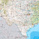
The geography of Texas is diverse and far reaching in scope. Occupying about 7% of the total water and land area of the U.S., it is the second largest state after Alaska
, and is the southernmost part of the Great Plains
, which end in the south against the folded Sierra Madre Oriental
of Mexico
. Texas
is in the south-central part of the United States of America, and is considered to form part of the U.S. South and also part of the U.S. Southwest.
By residents, the state is generally divided into North Texas
, East Texas
, Central Texas
, South Texas
, West Texas
(and sometimes the Panhandle
), but according to the Texas Almanac, Texas has four major physical regions: Gulf Coastal Plains, Interior Lowlands, Great Plains, and Basin and Range Province. This has been cited as the difference between human geography
and physical geography
, although the fact that Texas was granted (and retains to this day) the prerogative to divide into as many as five U.S. states
may be a historical motive for Texans defining their state as containing exactly five regions.
Some regions in Texas are more associated with the South than the Southwest (primarily East Texas
, Central Texas
, and North Texas
), while other regions share more similarities with the Southwest (primarily far West Texas
and South Texas
). The upper Panhandle
is considered by many to have more in common with parts of the plains Midwest
than either the South or Southwest. The size of Texas prohibits easy categorization of the entire state wholly in any recognized region of the United States; geographic, economic, and even cultural diversity between regions of the state preclude treating Texas as a region in its own right.
 Continental
, Mountain, and Modified Marine
are the three major climatic types
of Texas, with no distinguishable boundaries. Modified Marine, or subtropical, dominates the majority of the state. Texas has an annual precipitation
range from 60.57 inches (1,538.5 mm) in Jasper County, East Texas, to 9.43 inches (239.5 mm) in El Paso
. The record high of 120 °F (48.9 °C) was reached at Seymour
on August 12, 1936, and Monahans
on June 28, 1994. The low also ties at -23 °F in Tulia
on February 12, 1899, and Seminole
on February 8, 1933.
, 801 mi (1,289.1 km). The largest continental state is so expansive that El Paso
, in the western corner of the state, is closer to San Diego, California
than to Beaumont
, near the Louisiana state line; Beaumont, in turn, is closer to Jacksonville, Florida
than it is to El Paso. Texarkana
, in the northeastern corner of the state, is about the same distance from Chicago, Illinois as it is to El Paso, and Dalhart
, in the northwestern corner of the state, is closer to the state capitals of Kansas
, Colorado
, New Mexico
, Oklahoma
and Wyoming
than it is to Austin
, its own state capital.
The geographic center of Texas is about 15 miles (24.1 km) northeast of Brady
in northern McCulloch County. Guadalupe Peak
, at 8749 feet (2,666.7 m) above sea level
is the highest point in Texas. The lowest being sea level where Texas meets the Gulf of Mexico. Texas has five state forests and 120 state park
s for a total over 605000 acres (2,448.4 km²). There are 3,700 named streams and 15 major river systems flowing through 191000 miles (307,383.9 km) of Texas. Eventually emptying into seven major estuaries
, these rivers support over 212 reservoirs.
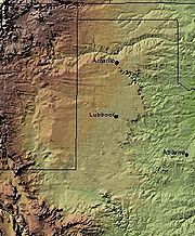
With 10 climatic regions
, 14 soil regions
, and 11 distinct ecological regions
, regional classification becomes problematic with differences in soils, topography, geology, rainfall, and plant and animal communities.
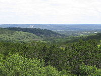
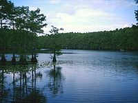 The Gulf Coastal Plains
extends from the Gulf of Mexico
inland to the Balcones Fault
and the Eastern Cross Timbers
. This large area, including the Texas barrier islands
, stretches from the cities of Paris
to San Antonio
to Del Rio
but shows a large variety in vegetation. With about 20 to over 58 inches (508-1,480 mm) annual rainfall, this is a nearly level, drained plain dissected by streams and rivers flowing into estuaries and marsh
es. Windblown sands and dunes, grasslands, oak mottes and salt marshes make up the seaward areas.
National Park
s include Big Thicket National Preserve, Padre Island National Seashore
and the Palo Alto Battlefield National Historic Site
.
 The North Central Plains are bounded by the Caprock Escarpment
to the west, the Edwards Plateau
to the south, and the Eastern Cross Timbers to the east. This area includes the North Central Plains around the cities of Abilene
and Wichita Falls
, the Western Cross Timbers to the west of Fort Worth
, the Grand Prairie, and the Eastern Cross Timbers to the east of Dallas
. With about 35 to 50 in (889 to 1,270 mm) annual rainfall, gently rolling to hilly forested land is part of a larger pine-hardwood forest of oak
s, hickories
, elm
and gum
trees. Soils vary from coarse sands to tight clays or red-bed clays and shales.
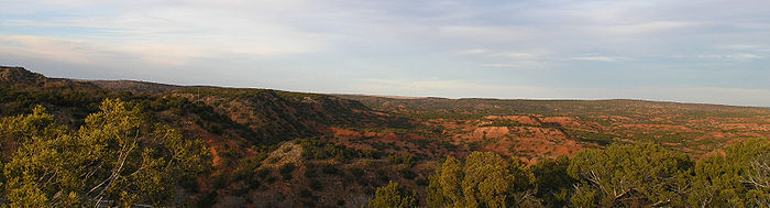
 The Great Plains
include the Llano Estacado
, the Panhandle
, Edwards Plateau
, Toyah Basin, and the Llano Uplift
. It is bordered on the east by the Caprock Escarpment
in the panhandle and by the Balcones Fault
to the southeast. Cities in this region include San Angelo
, Midland
and Odessa
, Lubbock
, and Amarillo
. The Hill Country
is a popular name for the area of hills along the Balcones Escarpment and is a transitional area between the Great Plains
and the Gulf Coastal Plains
. With about 15 to 31 in (381 to 787.4 mm) annual rainfall, the southern end of the Great Plains are gently rolling plains of shrub and grassland, and home to the dramatic Caprock Canyons
and Palo Duro Canyon
state parks. The largest concentration of playa lakes in the world (nearly 22,000) is on the Southern High Plains of Texas and Eastern New Mexico
.
Texas' blackland prairies
were some of the first areas farmed in Texas. Highly expansive clay
s with characteristic dark coloration, called the Houston Black series, occur on about 1.5 million acre
s (6,000 km²) extending from north of Dallas south to San Antonio. The Professional Soil Scientists Association of Texas has recommended to the State Legislature that the Houston Black series be designated the State soil. The series was established in 1902. National Parks in this area are the Lyndon B. Johnson National Historical Park
and the San Antonio Missions National Historical Park
.
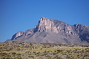
 The Trans-Pecos Natural Region has less than 12 inches (304.8 mm) annual rainfall. The most complex Natural Region, it includes Sand Hills, the Stockton Plateau, desert valleys, wooded mountain slopes and desert grasslands. The Basin and Range Province
is in extreme western Texas, west of the Pecos River
beginning with the Davis Mountains
on the east and the Rio Grande
to its west and south. The Trans-Pecos
region is the only part of Texas regarded as mountainous and includes seven named peaks in elevation greater than 8000 feet (2,438.4 m). This region includes sand hills, desert valleys, wooded mountain slopes and desert grasslands. The vegetation diversity includes at least 268 grass
species and 447 species of woody plant
s. National Parks include the Amistad National Recreation Area
, Big Bend National Park
, Chamizal National Memorial
, Fort Davis National Historic Site
, Guadalupe Mountains National Park
, and the Rio Grande Wild and Scenic River
.
This area is part of the Chihuahuan Desert
.
and younger sequence of sediments, the trace of ancient shorelines east and south until the active continental margin of the Gulf of Mexico
is met. This sequence is built atop the subsided crest of the Appalachian Mountains
–Ouachita Mountains
–Marathon Mountains
zone of Pennsylvanian
continental collision
, which collapsed when rifting in Jurassic
time opened the Gulf of Mexico. West from this orogenic
crest, which is buried beneath the Dallas
–Waco
–Austin
–San Antonio
trend, the sediments are Permian
and Triassic
in age. Oil
is found in the Cretaceous sediments in the east, the Permian sediments in the west, and along the Gulf coast and out on the Texas continental shelf
. A few exposures of Precambrian
igneous and metamorphic rock
s are found in the central and western parts of the state, and Oligocene
volcanic rocks are found in far west Texas, in the Big Bend area. A blanket of Miocene
sediments known as the Ogallala formation in the western high plains region is an important aquifer
. Texas has no active or dormant volcanoes and few earthquakes, being situated far from an active plate tectonic boundary. The Big Bend area is the most seismically active; however, the area is sparsely populated and suffers minimal damages and injuries, and no known fatalities have been attributed to a Texas earthquake.
s, Texas is a major agricultural
and industrial
state. It leads all other states in such categories as oil, cattle, sheep, and cotton. Texas also produces poultry, eggs, dairy products, greenhouse and nursery products, wheat, hay, rice, sugar cane, and peanuts, and a range of fruits and vegetables.
Alaska
Alaska is the largest state in the United States by area. It is situated in the northwest extremity of the North American continent, with Canada to the east, the Arctic Ocean to the north, and the Pacific Ocean to the west and south, with Russia further west across the Bering Strait...
, and is the southernmost part of the Great Plains
Great Plains
The Great Plains are a broad expanse of flat land, much of it covered in prairie, steppe and grassland, which lies west of the Mississippi River and east of the Rocky Mountains in the United States and Canada. This area covers parts of the U.S...
, which end in the south against the folded Sierra Madre Oriental
Sierra Madre Oriental
The Sierra Madre Oriental is a mountain range in northeastern Mexico.-Setting:Spanning the Sierra Madre Oriental runs from Coahuila south through Nuevo León, southwest Tamaulipas, San Luis Potosí, Querétaro, and Hidalgo to northern Puebla, where it joins with the east-west running Eje Volcánico...
of Mexico
Mexico
The United Mexican States , commonly known as Mexico , is a federal constitutional republic in North America. It is bordered on the north by the United States; on the south and west by the Pacific Ocean; on the southeast by Guatemala, Belize, and the Caribbean Sea; and on the east by the Gulf of...
. Texas
Texas
Texas is the second largest U.S. state by both area and population, and the largest state by area in the contiguous United States.The name, based on the Caddo word "Tejas" meaning "friends" or "allies", was applied by the Spanish to the Caddo themselves and to the region of their settlement in...
is in the south-central part of the United States of America, and is considered to form part of the U.S. South and also part of the U.S. Southwest.
By residents, the state is generally divided into North Texas
North Texas
North Texas is a distinct cultural and geographic area forming the central-northeastern section of the U.S. state of Texas. North Texas is generally considered to include the area south of Oklahoma, east of Abilene, and north of Waco...
, East Texas
East Texas
East Texas is a distinct geographic and ecological area in the U.S. state of Texas.According to the Handbook of Texas, the East Texas area "may be separated from the rest of Texas roughly by a line extending from the Red River in north central Lamar County southwestward to east central Limestone...
, Central Texas
Central Texas
Central Texas , is a region in the U.S. state of Texas. It is roughly bordered by San Marcos to Fredericksburg to Waco, and to Brenham, and includes the Austin–Round Rock, Killeen-Temple-Fort Hood, Bryan-College Station, and Waco metropolitan areas...
, South Texas
South Texas
South Texas is a region of the U.S. state of Texas that lies roughly south of and including San Antonio. The southern and western boundary is the Rio Grande River, and to the east it is the Gulf of Mexico. The population of this region is about 3.7 million. The southern portion of this region is...
, West Texas
West Texas
West Texas is a vernacular term applied to a region in the southwestern quadrant of the United States that primarily encompasses the arid and semi-arid lands in the western portion of the state of Texas....
(and sometimes the Panhandle
Texas Panhandle
The Texas Panhandle is a region of the U.S. state of Texas consisting of the northernmost 26 counties in the state. The panhandle is a rectangular area bordered by New Mexico to the west and Oklahoma to the north and east...
), but according to the Texas Almanac, Texas has four major physical regions: Gulf Coastal Plains, Interior Lowlands, Great Plains, and Basin and Range Province. This has been cited as the difference between human geography
Human geography
Human geography is one of the two major sub-fields of the discipline of geography. Human geography is the study of the world, its people, communities, and cultures. Human geography differs from physical geography mainly in that it has a greater focus on studying human activities and is more...
and physical geography
Physical geography
Physical geography is one of the two major subfields of geography. Physical geography is that branch of natural science which deals with the study of processes and patterns in the natural environment like the atmosphere, biosphere and geosphere, as opposed to the cultural or built environment, the...
, although the fact that Texas was granted (and retains to this day) the prerogative to divide into as many as five U.S. states
Texas divisionism
Texas divisionism is a mainly historical movement that advocates the division of the U.S. state of Texas into as many as five states, a prerogative guaranteed to Texas as a condition of the former Republic of Texas joining the Union in 1845....
may be a historical motive for Texans defining their state as containing exactly five regions.
Some regions in Texas are more associated with the South than the Southwest (primarily East Texas
East Texas
East Texas is a distinct geographic and ecological area in the U.S. state of Texas.According to the Handbook of Texas, the East Texas area "may be separated from the rest of Texas roughly by a line extending from the Red River in north central Lamar County southwestward to east central Limestone...
, Central Texas
Central Texas
Central Texas , is a region in the U.S. state of Texas. It is roughly bordered by San Marcos to Fredericksburg to Waco, and to Brenham, and includes the Austin–Round Rock, Killeen-Temple-Fort Hood, Bryan-College Station, and Waco metropolitan areas...
, and North Texas
North Texas
North Texas is a distinct cultural and geographic area forming the central-northeastern section of the U.S. state of Texas. North Texas is generally considered to include the area south of Oklahoma, east of Abilene, and north of Waco...
), while other regions share more similarities with the Southwest (primarily far West Texas
West Texas
West Texas is a vernacular term applied to a region in the southwestern quadrant of the United States that primarily encompasses the arid and semi-arid lands in the western portion of the state of Texas....
and South Texas
South Texas
South Texas is a region of the U.S. state of Texas that lies roughly south of and including San Antonio. The southern and western boundary is the Rio Grande River, and to the east it is the Gulf of Mexico. The population of this region is about 3.7 million. The southern portion of this region is...
). The upper Panhandle
Panhandle
A panhandle is an informal geographic term for an elongated arm-like protrusion of a geo-political entity, such as a subnational entity or a sovereign state.-Term:...
is considered by many to have more in common with parts of the plains Midwest
Midwestern United States
The Midwestern United States is one of the four U.S. geographic regions defined by the United States Census Bureau, providing an official definition of the American Midwest....
than either the South or Southwest. The size of Texas prohibits easy categorization of the entire state wholly in any recognized region of the United States; geographic, economic, and even cultural diversity between regions of the state preclude treating Texas as a region in its own right.
Climate
Continental climate
Continental climate is a climate characterized by important annual variation in temperature due to the lack of significant bodies of water nearby...
, Mountain, and Modified Marine
Subtropics
The subtropics are the geographical and climatical zone of the Earth immediately north and south of the tropical zone, which is bounded by the Tropic of Cancer and the Tropic of Capricorn, at latitudes 23.5°N and 23.5°S...
are the three major climatic types
Climate
Climate encompasses the statistics of temperature, humidity, atmospheric pressure, wind, rainfall, atmospheric particle count and other meteorological elemental measurements in a given region over long periods...
of Texas, with no distinguishable boundaries. Modified Marine, or subtropical, dominates the majority of the state. Texas has an annual precipitation
Precipitation (meteorology)
In meteorology, precipitation In meteorology, precipitation In meteorology, precipitation (also known as one of the classes of hydrometeors, which are atmospheric water phenomena is any product of the condensation of atmospheric water vapor that falls under gravity. The main forms of precipitation...
range from 60.57 inches (1,538.5 mm) in Jasper County, East Texas, to 9.43 inches (239.5 mm) in El Paso
El Paso, Texas
El Paso, is a city in and the county seat of El Paso County, Texas, United States, and lies in far West Texas. In the 2010 census, the city had a population of 649,121. It is the sixth largest city in Texas and the 19th largest city in the United States...
. The record high of 120 °F (48.9 °C) was reached at Seymour
Seymour, Texas
Seymour is a city in and the county seat of Baylor County, Texas, United States. The population was 2,740 as of the 2010 Census.-Geography:Seymour is located at ....
on August 12, 1936, and Monahans
Monahans, Texas
Monahans is a city in and the county seat of Ward County, Texas, United States. A very small portion of the city extends into Winkler County. The population was 6,821 at the 2000 census.-History:...
on June 28, 1994. The low also ties at -23 °F in Tulia
Tulia, Texas
Tulia is a city in, and county seat of, Swisher County, Texas, United States. The population was 5,117 at the 2000 census; in the 2005 census estimate, it had fallen to 4,714. The city is at the junction of U.S. Route 87 and Texas State Highway 86, approximately two miles east Interstate 27...
on February 12, 1899, and Seminole
Seminole, Texas
Seminole is a city in and the county seat of Gaines County in west Texas, United States. The population was 6,430 at the 2010 census. It is the birthplace of Country music singers Larry Gatlin and Tanya Tucker...
on February 8, 1933.
Physical geography
Texas covers a total area of 268581 sq mi (695,621.6 km²). The longest straight line distance is from the northwest corner of the panhandle to the Rio Grande just below BrownsvilleBrownsville, Texas
Brownsville is a city in the southernmost tip of the state of Texas, in the United States. It is located on the northern bank of the Rio Grande, directly north and across the border from Matamoros, Tamaulipas, Mexico. Brownsville is the 16th largest city in the state of Texas with a population of...
, 801 mi (1,289.1 km). The largest continental state is so expansive that El Paso
El Paso, Texas
El Paso, is a city in and the county seat of El Paso County, Texas, United States, and lies in far West Texas. In the 2010 census, the city had a population of 649,121. It is the sixth largest city in Texas and the 19th largest city in the United States...
, in the western corner of the state, is closer to San Diego, California
San Diego, California
San Diego is the eighth-largest city in the United States and second-largest city in California. The city is located on the coast of the Pacific Ocean in Southern California, immediately adjacent to the Mexican border. The birthplace of California, San Diego is known for its mild year-round...
than to Beaumont
Beaumont, Texas
Beaumont is a city in and county seat of Jefferson County, Texas, United States, within the Beaumont–Port Arthur Metropolitan Statistical Area. The city's population was 118,296 at the 2010 census. With Port Arthur and Orange, it forms the Golden Triangle, a major industrial area on the...
, near the Louisiana state line; Beaumont, in turn, is closer to Jacksonville, Florida
Jacksonville, Florida
Jacksonville is the largest city in the U.S. state of Florida in terms of both population and land area, and the largest city by area in the contiguous United States. It is the county seat of Duval County, with which the city government consolidated in 1968...
than it is to El Paso. Texarkana
Texarkana, Texas
Texarkana is a city in Bowie County, Texas, United States. It effectively functions as one half of a city which crosses a state line — the other half, the city of Texarkana, Arkansas, lies on the other side of State Line Avenue...
, in the northeastern corner of the state, is about the same distance from Chicago, Illinois as it is to El Paso, and Dalhart
Dalhart, Texas
Dalhart is a city in Dallam and Hartley counties in the U.S. state of Texas, and the county seat of Dallam County. The population was 7,237 at the 2000 census. Founded in 1901, Dalhart is named for its location on the border of Dallam and Hartley counties. Dalhart sits at the intersection of U.S....
, in the northwestern corner of the state, is closer to the state capitals of Kansas
Kansas
Kansas is a US state located in the Midwestern United States. It is named after the Kansas River which flows through it, which in turn was named after the Kansa Native American tribe, which inhabited the area. The tribe's name is often said to mean "people of the wind" or "people of the south...
, Colorado
Colorado
Colorado is a U.S. state that encompasses much of the Rocky Mountains as well as the northeastern portion of the Colorado Plateau and the western edge of the Great Plains...
, New Mexico
New Mexico
New Mexico is a state located in the southwest and western regions of the United States. New Mexico is also usually considered one of the Mountain States. With a population density of 16 per square mile, New Mexico is the sixth-most sparsely inhabited U.S...
, Oklahoma
Oklahoma
Oklahoma is a state located in the South Central region of the United States of America. With an estimated 3,751,351 residents as of the 2010 census and a land area of 68,667 square miles , Oklahoma is the 28th most populous and 20th-largest state...
and Wyoming
Wyoming
Wyoming is a state in the mountain region of the Western United States. The western two thirds of the state is covered mostly with the mountain ranges and rangelands in the foothills of the Eastern Rocky Mountains, while the eastern third of the state is high elevation prairie known as the High...
than it is to Austin
Austin, Texas
Austin is the capital city of the U.S. state of :Texas and the seat of Travis County. Located in Central Texas on the eastern edge of the American Southwest, it is the fourth-largest city in Texas and the 14th most populous city in the United States. It was the third-fastest-growing large city in...
, its own state capital.
The geographic center of Texas is about 15 miles (24.1 km) northeast of Brady
Brady
Brady is a surname derived from the Irish surname Mac Brádaigh.In a listing by the U.S. Census Bureau of the Brady is ranked at #411.-Notable Bradys:*Alice Brady , American silent-film actress, Best Supporting Actress Oscar winner...
in northern McCulloch County. Guadalupe Peak
Guadalupe Peak
Guadalupe Peak is the highest natural point in Texas, with an elevation of . It is located in Guadalupe Mountains National Park, and is part of the Guadalupe Mountains range in southeastern New Mexico and West Texas. The mountain is about east of El Paso and about southwest of Carlsbad, New Mexico...
, at 8749 feet (2,666.7 m) above sea level
Sea level
Mean sea level is a measure of the average height of the ocean's surface ; used as a standard in reckoning land elevation...
is the highest point in Texas. The lowest being sea level where Texas meets the Gulf of Mexico. Texas has five state forests and 120 state park
State park
State parks are parks or other protected areas managed at the federated state level within those nations which use "state" as a political subdivision. State parks are typically established by a state to preserve a location on account of its natural beauty, historic interest, or recreational...
s for a total over 605000 acres (2,448.4 km²). There are 3,700 named streams and 15 major river systems flowing through 191000 miles (307,383.9 km) of Texas. Eventually emptying into seven major estuaries
Estuary
An estuary is a partly enclosed coastal body of water with one or more rivers or streams flowing into it, and with a free connection to the open sea....
, these rivers support over 212 reservoirs.
With 10 climatic regions
Köppen climate classification
The Köppen climate classification is one of the most widely used climate classification systems. It was first published by Crimea German climatologist Wladimir Köppen in 1884, with several later modifications by Köppen himself, notably in 1918 and 1936...
, 14 soil regions
Agricultural soil science
Agricultural soil science is a branch of soil science that deals with the study of edaphic conditions as they relate to the production of food and fiber. In this context, it is also a constituent of the field of agronomy.-History:...
, and 11 distinct ecological regions
Ecoregion
An ecoregion , sometimes called a bioregion, is an ecologically and geographically defined area that is smaller than an ecozone and larger than an ecosystem. Ecoregions cover relatively large areas of land or water, and contain characteristic, geographically distinct assemblages of natural...
, regional classification becomes problematic with differences in soils, topography, geology, rainfall, and plant and animal communities.
Coastal Plains
Gulf Coastal Plains
The Texas Coastal Bend refers to the flat area of land along the Texas coast. It is home to many cities including Brownsville, Corpus Christi, Kingsville, Port Lavaca, Galveston, Victoria, Beaumont, and Houston. The Coastal Bend includes the barrier islands of Texas and the Laguna Madre...
extends from the Gulf of Mexico
Gulf of Mexico
The Gulf of Mexico is a partially landlocked ocean basin largely surrounded by the North American continent and the island of Cuba. It is bounded on the northeast, north and northwest by the Gulf Coast of the United States, on the southwest and south by Mexico, and on the southeast by Cuba. In...
inland to the Balcones Fault
Balcones Fault
The Balcones Fault Zone is a tensional structural system in Texas that runs approximately from the southwest part of the state near Del Rio to the north central region near Waco along Interstate 35. The Balcones Fault zone is made up of many smaller features, including normal faults, grabens, and...
and the Eastern Cross Timbers
Cross Timbers
The term Cross Timbers is used to describe a strip of land in the United States that runs from southeastern Kansas across Central Oklahoma to Central Texas...
. This large area, including the Texas barrier islands
Texas barrier islands
The Texas barrier islands are some barrier islands in the Gulf of Mexico at the coast of Texas. The islands attract tourists for activities such as dolphin watching...
, stretches from the cities of Paris
Paris, Texas
Paris, Texas is a city located northeast of the Dallas–Fort Worth Metroplex in Lamar County, Texas, in the United States. It is situated in Northeast Texas at the western edge of the Piney Woods. Physiographically, these regions are part of the West Gulf Coastal Plain. In 1900, 9,358 people lived...
to San Antonio
San Antonio, Texas
San Antonio is the seventh-largest city in the United States of America and the second-largest city within the state of Texas, with a population of 1.33 million. Located in the American Southwest and the south–central part of Texas, the city serves as the seat of Bexar County. In 2011,...
to Del Rio
Del Rio, Texas
Del Rio is a border city in and the county seat of Val Verde County, Texas, United States.. Del Rio is connected with Ciudad Acuña via the Lake Amistad Dam International Crossing and Del Río-Ciudad Acuña International Bridge...
but shows a large variety in vegetation. With about 20 to over 58 inches (508-1,480 mm) annual rainfall, this is a nearly level, drained plain dissected by streams and rivers flowing into estuaries and marsh
Marsh
In geography, a marsh, or morass, is a type of wetland that is subject to frequent or continuous flood. Typically the water is shallow and features grasses, rushes, reeds, typhas, sedges, other herbaceous plants, and moss....
es. Windblown sands and dunes, grasslands, oak mottes and salt marshes make up the seaward areas.
National Park
National park
A national park is a reserve of natural, semi-natural, or developed land that a sovereign state declares or owns. Although individual nations designate their own national parks differently A national park is a reserve of natural, semi-natural, or developed land that a sovereign state declares or...
s include Big Thicket National Preserve, Padre Island National Seashore
Padre Island National Seashore
Padre Island National Seashore is a National Seashore located on Padre Island off the coast of South Texas. In contrast to South Padre Island , PINS is located on North Padre Island and consists of a long beach where nature is preserved...
and the Palo Alto Battlefield National Historic Site
Palo Alto Battlefield National Historic Site
Palo Alto Battlefield National Historical Park near Brownsville, Texas preserves the grounds of the May 8, 1846, Battle of Palo Alto. It was the first major conflict in a border dispute that soon precipitated the Mexican-American War. The United States Army victory here made the invasion of Mexico...
.
North Central Plains
Caprock Escarpment
The Caprock Escarpment is a term used in Texas and Eastern New Mexico to describe the geographical transition point between the level elevated plains of the Llano Estacado and the surrounding rolling terrain. In Texas, the escarpment stretches around 320 km south-southwest from the northeast...
to the west, the Edwards Plateau
Edwards Plateau
The Edwards Plateau is a region of west-central Texas which is bounded by the Balcones Fault to the south and east, the Llano Uplift and the Llano Estacado to the north, and the Pecos River and Chihuahuan Desert to the west. San Angelo, Austin, San Antonio and Del Rio roughly outline the area...
to the south, and the Eastern Cross Timbers to the east. This area includes the North Central Plains around the cities of Abilene
Abilene, Texas
Abilene is a city in Taylor and Jones counties in west central Texas. The population was 117,063 at the 2010 census. It is the principal city of the Abilene Metropolitan Statistical Area, which had a 2006 estimated population of 158,063. It is the county seat of Taylor County...
and Wichita Falls
Wichita Falls, Texas
Wichita Falls is a city in and the county seat of Wichita County, Texas, United States, United States. Wichita Falls is the principal city of the Wichita Falls Metropolitan Statistical Area, which encompasses all of Archer, Clay and Wichita counties. According to the U.S. Census estimate of 2010,...
, the Western Cross Timbers to the west of Fort Worth
Fort Worth, Texas
Fort Worth is the 16th-largest city in the United States of America and the fifth-largest city in the state of Texas. Located in North Central Texas, just southeast of the Texas Panhandle, the city is a cultural gateway into the American West and covers nearly in Tarrant, Parker, Denton, and...
, the Grand Prairie, and the Eastern Cross Timbers to the east of Dallas
Dallas, Texas
Dallas is the third-largest city in Texas and the ninth-largest in the United States. The Dallas-Fort Worth Metroplex is the largest metropolitan area in the South and fourth-largest metropolitan area in the United States...
. With about 35 to 50 in (889 to 1,270 mm) annual rainfall, gently rolling to hilly forested land is part of a larger pine-hardwood forest of oak
Oak
An oak is a tree or shrub in the genus Quercus , of which about 600 species exist. "Oak" may also appear in the names of species in related genera, notably Lithocarpus...
s, hickories
Hickory
Trees in the genus Carya are commonly known as hickory, derived from the Powhatan language of Virginia. The genus includes 17–19 species of deciduous trees with pinnately compound leaves and big nuts...
, elm
Elm
Elms are deciduous and semi-deciduous trees comprising the genus Ulmus in the plant family Ulmaceae. The dozens of species are found in temperate and tropical-montane regions of North America and Eurasia, ranging southward into Indonesia. Elms are components of many kinds of natural forests...
and gum
Eucalyptus
Eucalyptus is a diverse genus of flowering trees in the myrtle family, Myrtaceae. Members of the genus dominate the tree flora of Australia...
trees. Soils vary from coarse sands to tight clays or red-bed clays and shales.
Great Plains
Great Plains
The Great Plains are a broad expanse of flat land, much of it covered in prairie, steppe and grassland, which lies west of the Mississippi River and east of the Rocky Mountains in the United States and Canada. This area covers parts of the U.S...
include the Llano Estacado
Llano Estacado
Llano Estacado , commonly known as the Staked Plains, is a region in the Southwestern United States that encompasses parts of eastern New Mexico and northwestern Texas, including the South Plains and parts of the Texas Panhandle...
, the Panhandle
Texas Panhandle
The Texas Panhandle is a region of the U.S. state of Texas consisting of the northernmost 26 counties in the state. The panhandle is a rectangular area bordered by New Mexico to the west and Oklahoma to the north and east...
, Edwards Plateau
Edwards Plateau
The Edwards Plateau is a region of west-central Texas which is bounded by the Balcones Fault to the south and east, the Llano Uplift and the Llano Estacado to the north, and the Pecos River and Chihuahuan Desert to the west. San Angelo, Austin, San Antonio and Del Rio roughly outline the area...
, Toyah Basin, and the Llano Uplift
Llano Uplift
The Llano Uplift is a roughly circular geologic dome of Precambrian rock, primarily granite, in Central Texas in the United States. It is located in the eastern region of the Edwards Plateau, west of the Texas Hill Country...
. It is bordered on the east by the Caprock Escarpment
Caprock Escarpment
The Caprock Escarpment is a term used in Texas and Eastern New Mexico to describe the geographical transition point between the level elevated plains of the Llano Estacado and the surrounding rolling terrain. In Texas, the escarpment stretches around 320 km south-southwest from the northeast...
in the panhandle and by the Balcones Fault
Balcones Fault
The Balcones Fault Zone is a tensional structural system in Texas that runs approximately from the southwest part of the state near Del Rio to the north central region near Waco along Interstate 35. The Balcones Fault zone is made up of many smaller features, including normal faults, grabens, and...
to the southeast. Cities in this region include San Angelo
San Angelo, Texas
San Angelo is a city in the state of Texas. Located in West Central Texas it is the county seat of Tom Green County. As of 2010 according to the United States Census Bureau, the city had a total population of 93,200...
, Midland
Midland, Texas
Midland is a city in and the county seat of Midland County, Texas, United States, on the Southern Plains of the state's western area. A small portion of the city extends into Martin County. As of 2010, the population of Midland was 111,147. It is the principal city of the Midland, Texas...
and Odessa
Odessa, Texas
Odessa is a city in and the county seat of Ector County, Texas, United States. It is located primarily in Ector County, although a small portion of the city extends into Midland County. Odessa's population was 99,940 at the 2010 census. It is the principal city of the Odessa, Texas Metropolitan...
, Lubbock
Lubbock, Texas
Lubbock is a city in and the county seat of Lubbock County, Texas, United States. The city is located in the northwestern part of the state, a region known historically as the Llano Estacado, and the home of Texas Tech University and Lubbock Christian University...
, and Amarillo
Amarillo, Texas
Amarillo is the 14th-largest city, by population, in the state of Texas, the largest in the Texas Panhandle, and the seat of Potter County. A portion of the city extends into Randall County. The population was 190,695 at the 2010 census...
. The Hill Country
Texas Hill Country
The Texas Hill Country is a vernacular term applied to a region of Central Texas featuring tall rugged hills consisting of thin layers of soil atop limestone or granite. It also includes the Llano Uplift and the second largest granite monadnock in the United States, Enchanted Rock, which is located...
is a popular name for the area of hills along the Balcones Escarpment and is a transitional area between the Great Plains
Great Plains
The Great Plains are a broad expanse of flat land, much of it covered in prairie, steppe and grassland, which lies west of the Mississippi River and east of the Rocky Mountains in the United States and Canada. This area covers parts of the U.S...
and the Gulf Coastal Plains
Gulf Coastal Plains
The Texas Coastal Bend refers to the flat area of land along the Texas coast. It is home to many cities including Brownsville, Corpus Christi, Kingsville, Port Lavaca, Galveston, Victoria, Beaumont, and Houston. The Coastal Bend includes the barrier islands of Texas and the Laguna Madre...
. With about 15 to 31 in (381 to 787.4 mm) annual rainfall, the southern end of the Great Plains are gently rolling plains of shrub and grassland, and home to the dramatic Caprock Canyons
Caprock Canyons State Park and Trailway
Caprock Canyons State Park and Trailway is a Texas state park on the Caprock Escarpment in Briscoe County, Texas, United States, approximately southeast of Amarillo...
and Palo Duro Canyon
Palo Duro Canyon
Palo Duro Canyon is a canyon system of the Caprock Escarpment located in the Texas Panhandle near the city of Amarillo, Texas, United States. As the second largest canyon in the United States, it is roughly long and has an average width of , but reaches a width of at places. Its depth is around...
state parks. The largest concentration of playa lakes in the world (nearly 22,000) is on the Southern High Plains of Texas and Eastern New Mexico
New Mexico
New Mexico is a state located in the southwest and western regions of the United States. New Mexico is also usually considered one of the Mountain States. With a population density of 16 per square mile, New Mexico is the sixth-most sparsely inhabited U.S...
.
Texas' blackland prairies
Texas blackland prairies
The Texas Blackland Prairies are a temperate grassland ecoregion located in Texas that runs roughly from the Red River in North Texas to San Antonio in the south.-Setting:...
were some of the first areas farmed in Texas. Highly expansive clay
Clay
Clay is a general term including many combinations of one or more clay minerals with traces of metal oxides and organic matter. Geologic clay deposits are mostly composed of phyllosilicate minerals containing variable amounts of water trapped in the mineral structure.- Formation :Clay minerals...
s with characteristic dark coloration, called the Houston Black series, occur on about 1.5 million acre
Acre
The acre is a unit of area in a number of different systems, including the imperial and U.S. customary systems. The most commonly used acres today are the international acre and, in the United States, the survey acre. The most common use of the acre is to measure tracts of land.The acre is related...
s (6,000 km²) extending from north of Dallas south to San Antonio. The Professional Soil Scientists Association of Texas has recommended to the State Legislature that the Houston Black series be designated the State soil. The series was established in 1902. National Parks in this area are the Lyndon B. Johnson National Historical Park
Lyndon B. Johnson National Historical Park
Lyndon B. Johnson National Historical Park is a United States National Historical Park in central Texas about 50 miles west of Austin in the Texas Hill Country. The park protects the birthplace, home, ranch and final resting place of Lyndon B. Johnson, 36th President of the United States...
and the San Antonio Missions National Historical Park
San Antonio Missions National Historical Park
San Antonio Missions National Historical Park preserves four of the five Spanish frontier missions in San Antonio, Texas. These outposts were established by Catholic religious orders to spread Christianity among the local natives...
.
Mountains and Basins
Basin and Range
The Basin and Range Province is a vast physiographic region defined by a unique topographic expression. Basin and Range topography is characterized by abrupt changes in elevation, alternating between narrow faulted mountain chains and flat arid valleys or basins...
is in extreme western Texas, west of the Pecos River
Pecos River
The headwaters of the Pecos River are located north of Pecos, New Mexico, United States, at an elevation of over 12,000 feet on the western slope of the Sangre de Cristo mountain range in Mora County. The river flows for through the eastern portion of that state and neighboring Texas before it...
beginning with the Davis Mountains
Davis Mountains
The Davis Mountains are a range of mountains in West Texas, located near Fort Davis, after which they are named. They are a popular site for camping and hiking and the region includes Fort Davis National Historic Site and Davis Mountains State Park...
on the east and the Rio Grande
Rio Grande
The Rio Grande is a river that flows from southwestern Colorado in the United States to the Gulf of Mexico. Along the way it forms part of the Mexico – United States border. Its length varies as its course changes...
to its west and south. The Trans-Pecos
Trans-Pecos
The term Trans-Pecos, as originally defined in 1887 by the Texas geologist Robert T. Hill, refers to the portion of Texas that lies west of the Pecos River. The term is considered synonymous with "Far West Texas", a subdivision of West Texas...
region is the only part of Texas regarded as mountainous and includes seven named peaks in elevation greater than 8000 feet (2,438.4 m). This region includes sand hills, desert valleys, wooded mountain slopes and desert grasslands. The vegetation diversity includes at least 268 grass
Grass
Grasses, or more technically graminoids, are monocotyledonous, usually herbaceous plants with narrow leaves growing from the base. They include the "true grasses", of the Poaceae family, as well as the sedges and the rushes . The true grasses include cereals, bamboo and the grasses of lawns ...
species and 447 species of woody plant
Woody plant
A woody plant is a plant that uses wood as its structural tissue. These are typically perennial plants whose stems and larger roots are reinforced with wood produced adjacent to the vascular tissues. The main stem, larger branches, and roots of these plants are usually covered by a layer of...
s. National Parks include the Amistad National Recreation Area
Amistad National Recreation Area
Amistad National Recreation Area includes the area around the Amistad Reservoir at the confluence of the Rio Grande River, the Devils River, and the Pecos River. "Amistad" is Spanish for "friendship", as the Amistad Reservoir is located on the border with Mexico...
, Big Bend National Park
Big Bend National Park
Big Bend National Park is a national park located in the U.S. state of Texas. Big Bend has national significance as the largest protected area of Chihuahuan Desert topography and ecology in the United States, which includes more than 1,200 species of plants, more than 450 species of birds, 56...
, Chamizal National Memorial
Chamizal National Memorial
Chamizal National Memorial, located in El Paso, Texas, along the United States–Mexico international border, commemorates the peaceful settlement of the Chamizal boundary dispute....
, Fort Davis National Historic Site
Fort Davis National Historic Site
Fort Davis National Historic Site is a United States National Historic Site located in unincorporated Jeff Davis County, Texas. Located within the Davis Mountains of West Texas, the historic site was established in 1961 to protect one of the best remaining examples of a United States Army fort in...
, Guadalupe Mountains National Park
Guadalupe Mountains National Park
Guadalupe Mountains National Park is located in the Guadalupe Mountains of West Texas and contains Guadalupe Peak, the highest point in Texas at in elevation. It also contains El Capitan, long used as a landmark by people traveling along the old route later followed by the Butterfield Overland...
, and the Rio Grande Wild and Scenic River
Rio Grande Wild and Scenic River
The Rio Grande Wild and Scenic River protects a 196 mile portion of the Rio Grande in Texas. Parts of Brewster, Terrell, and Val Verde counties are included in this section of the river....
.
This area is part of the Chihuahuan Desert
Chihuahuan Desert
The Chihuahuan Desert is a desert, and an ecoregion designation, that straddles the U.S.-Mexico border in the central and northern portions of the Mexican Plateau, bordered on the west by the extensive Sierra Madre Occidental range, and overlaying northern portions of the east range, the Sierra...
.
Geology
Texas is mostly sedimentary rocks, with east Texas underlain by a CretaceousCretaceous
The Cretaceous , derived from the Latin "creta" , usually abbreviated K for its German translation Kreide , is a geologic period and system from circa to million years ago. In the geologic timescale, the Cretaceous follows the Jurassic period and is followed by the Paleogene period of the...
and younger sequence of sediments, the trace of ancient shorelines east and south until the active continental margin of the Gulf of Mexico
Gulf of Mexico
The Gulf of Mexico is a partially landlocked ocean basin largely surrounded by the North American continent and the island of Cuba. It is bounded on the northeast, north and northwest by the Gulf Coast of the United States, on the southwest and south by Mexico, and on the southeast by Cuba. In...
is met. This sequence is built atop the subsided crest of the Appalachian Mountains
Appalachian Mountains
The Appalachian Mountains #Whether the stressed vowel is or ,#Whether the "ch" is pronounced as a fricative or an affricate , and#Whether the final vowel is the monophthong or the diphthong .), often called the Appalachians, are a system of mountains in eastern North America. The Appalachians...
–Ouachita Mountains
Ouachita Mountains
The Ouachita Mountains are a mountain range in west central Arkansas and southeastern Oklahoma. The range's subterranean roots may extend as far as central Texas, or beyond it to the current location of the Marathon Uplift. Along with the Ozark Mountains, the Ouachita Mountains form the U.S...
–Marathon Mountains
Marathon Uplift
The Marathon Uplift is a Tertiary-age domal uplift, approximately in diameter, in southwest Texas. The Marathon Basin was created by erosion of Cretaceous and younger strata from the crest of the uplift...
zone of Pennsylvanian
Pennsylvanian
The Pennsylvanian is, in the ICS geologic timescale, the younger of two subperiods of the Carboniferous Period. It lasted from roughly . As with most other geochronologic units, the rock beds that define the Pennsylvanian are well identified, but the exact date of the start and end are uncertain...
continental collision
Continental collision
Continental collision is a phenomenon of the plate tectonics of Earth that occurs at convergent boundaries. Continental collision is a variation on the fundamental process of subduction, whereby the subduction zone is destroyed, mountains produced, and two continents sutured together...
, which collapsed when rifting in Jurassic
Jurassic
The Jurassic is a geologic period and system that extends from about Mya to Mya, that is, from the end of the Triassic to the beginning of the Cretaceous. The Jurassic constitutes the middle period of the Mesozoic era, also known as the age of reptiles. The start of the period is marked by...
time opened the Gulf of Mexico. West from this orogenic
Orogeny
Orogeny refers to forces and events leading to a severe structural deformation of the Earth's crust due to the engagement of tectonic plates. Response to such engagement results in the formation of long tracts of highly deformed rock called orogens or orogenic belts...
crest, which is buried beneath the Dallas
Dallas, Texas
Dallas is the third-largest city in Texas and the ninth-largest in the United States. The Dallas-Fort Worth Metroplex is the largest metropolitan area in the South and fourth-largest metropolitan area in the United States...
–Waco
Waco, Texas
Waco is a city in and the county seat of McLennan County, Texas. Situated along the Brazos River and on the I-35 corridor, halfway between Dallas and Austin, it is the economic, cultural, and academic center of the 'Heart of Texas' region....
–Austin
Austin, Texas
Austin is the capital city of the U.S. state of :Texas and the seat of Travis County. Located in Central Texas on the eastern edge of the American Southwest, it is the fourth-largest city in Texas and the 14th most populous city in the United States. It was the third-fastest-growing large city in...
–San Antonio
San Antonio, Texas
San Antonio is the seventh-largest city in the United States of America and the second-largest city within the state of Texas, with a population of 1.33 million. Located in the American Southwest and the south–central part of Texas, the city serves as the seat of Bexar County. In 2011,...
trend, the sediments are Permian
Permian
The PermianThe term "Permian" was introduced into geology in 1841 by Sir Sir R. I. Murchison, president of the Geological Society of London, who identified typical strata in extensive Russian explorations undertaken with Edouard de Verneuil; Murchison asserted in 1841 that he named his "Permian...
and Triassic
Triassic
The Triassic is a geologic period and system that extends from about 250 to 200 Mya . As the first period of the Mesozoic Era, the Triassic follows the Permian and is followed by the Jurassic. Both the start and end of the Triassic are marked by major extinction events...
in age. Oil
Petroleum
Petroleum or crude oil is a naturally occurring, flammable liquid consisting of a complex mixture of hydrocarbons of various molecular weights and other liquid organic compounds, that are found in geologic formations beneath the Earth's surface. Petroleum is recovered mostly through oil drilling...
is found in the Cretaceous sediments in the east, the Permian sediments in the west, and along the Gulf coast and out on the Texas continental shelf
Continental shelf
The continental shelf is the extended perimeter of each continent and associated coastal plain. Much of the shelf was exposed during glacial periods, but is now submerged under relatively shallow seas and gulfs, and was similarly submerged during other interglacial periods. The continental margin,...
. A few exposures of Precambrian
Precambrian
The Precambrian is the name which describes the large span of time in Earth's history before the current Phanerozoic Eon, and is a Supereon divided into several eons of the geologic time scale...
igneous and metamorphic rock
Metamorphic rock
Metamorphic rock is the transformation of an existing rock type, the protolith, in a process called metamorphism, which means "change in form". The protolith is subjected to heat and pressure causing profound physical and/or chemical change...
s are found in the central and western parts of the state, and Oligocene
Oligocene
The Oligocene is a geologic epoch of the Paleogene Period and extends from about 34 million to 23 million years before the present . As with other older geologic periods, the rock beds that define the period are well identified but the exact dates of the start and end of the period are slightly...
volcanic rocks are found in far west Texas, in the Big Bend area. A blanket of Miocene
Miocene
The Miocene is a geological epoch of the Neogene Period and extends from about . The Miocene was named by Sir Charles Lyell. Its name comes from the Greek words and and means "less recent" because it has 18% fewer modern sea invertebrates than the Pliocene. The Miocene follows the Oligocene...
sediments known as the Ogallala formation in the western high plains region is an important aquifer
Aquifer
An aquifer is a wet underground layer of water-bearing permeable rock or unconsolidated materials from which groundwater can be usefully extracted using a water well. The study of water flow in aquifers and the characterization of aquifers is called hydrogeology...
. Texas has no active or dormant volcanoes and few earthquakes, being situated far from an active plate tectonic boundary. The Big Bend area is the most seismically active; however, the area is sparsely populated and suffers minimal damages and injuries, and no known fatalities have been attributed to a Texas earthquake.
Resources
With enormous natural resourceNatural resource
Natural resources occur naturally within environments that exist relatively undisturbed by mankind, in a natural form. A natural resource is often characterized by amounts of biodiversity and geodiversity existent in various ecosystems....
s, Texas is a major agricultural
Agriculture
Agriculture is the cultivation of animals, plants, fungi and other life forms for food, fiber, and other products used to sustain life. Agriculture was the key implement in the rise of sedentary human civilization, whereby farming of domesticated species created food surpluses that nurtured the...
and industrial
Industry
Industry refers to the production of an economic good or service within an economy.-Industrial sectors:There are four key industrial economic sectors: the primary sector, largely raw material extraction industries such as mining and farming; the secondary sector, involving refining, construction,...
state. It leads all other states in such categories as oil, cattle, sheep, and cotton. Texas also produces poultry, eggs, dairy products, greenhouse and nursery products, wheat, hay, rice, sugar cane, and peanuts, and a range of fruits and vegetables.
- AsphaltAsphaltAsphalt or , also known as bitumen, is a sticky, black and highly viscous liquid or semi-solid that is present in most crude petroleums and in some natural deposits, it is a substance classed as a pitch...
-bearing rocks, mainly cretaceous limestones, occur in BexarBexar County, TexasAs of the census of 2000, there were 1,392,931 people, 488,942 households, and 345,681 families residing in the county. The population density was 1,117 people per square mile . There were 521,359 housing units at an average density of 418 per square mile...
, BurnetBurnet- Living things:* Plants in the genus Sanguisorba* Moths in the genus Zygaena * Salad Burnet or Burnet, European borage salad* Burnet Saxifrage, a plant used as a herb- People with surname Burnet:...
, KinneyKinney-People:* Jeff Kinney, football athlete* Jeff Kinney * Kathy Kinney, actress-Places:United States* Kinney, Minnesota* Kinney County, Texas* Kenney, Texas, a community also called "Kinney"Canada* Kinney Lake, in British Columbia-Other uses:* G.R...
, UvaldeUvaldeUvalde may refer to:*Uvalde County - a county in south Texas*Uvalde, Texas - a city and the Uvalde County seat*Uvalde Estates - a census-designated place in Uvalde County...
, and other counties. - CementCementIn the most general sense of the word, a cement is a binder, a substance that sets and hardens independently, and can bind other materials together. The word "cement" traces to the Romans, who used the term opus caementicium to describe masonry resembling modern concrete that was made from crushed...
is currently produced in Bexar, Comal, Dallas, Ector, Ellis, El Paso, Harris, Hays, McLennan, Nolan, Nueces, Potter, and Tarrant counties. Historically, Texas' Portland cement output accounts for about 10% of the annual United States production. - With an abundance of various types of clayClayClay is a general term including many combinations of one or more clay minerals with traces of metal oxides and organic matter. Geologic clay deposits are mostly composed of phyllosilicate minerals containing variable amounts of water trapped in the mineral structure.- Formation :Clay minerals...
s, Texas is one of the leading producers of clays. - Bituminous coalBituminous coalBituminous coal or black coal is a relatively soft coal containing a tarlike substance called bitumen. It is of higher quality than lignite coal but of poorer quality than Anthracite...
occurs primarily in Coleman, Eastland, Erath, Jack, McCulloch, Montague, Palo Pinto, Parker, Throckmorton, Wise, and Young counties of Texas. LigniteLigniteLignite, often referred to as brown coal, or Rosebud coal by Northern Pacific Railroad,is a soft brown fuel with characteristics that put it somewhere between coal and peat...
, or brown coal, occurs in deposits in the Texas Coastal Plain. - Fluorspar or fluoriteFluoriteFluorite is a halide mineral composed of calcium fluoride, CaF2. It is an isometric mineral with a cubic habit, though octahedral and more complex isometric forms are not uncommon...
is an important industrial mineral used in the manufacture of steelSteelSteel is an alloy that consists mostly of iron and has a carbon content between 0.2% and 2.1% by weight, depending on the grade. Carbon is the most common alloying material for iron, but various other alloying elements are used, such as manganese, chromium, vanadium, and tungsten...
, aluminum, glassGlassGlass is an amorphous solid material. Glasses are typically brittle and optically transparent.The most familiar type of glass, used for centuries in windows and drinking vessels, is soda-lime glass, composed of about 75% silica plus Na2O, CaO, and several minor additives...
, and fluorocarbons. It occurs at several localities in the Trans-Pecos and Llano regions of Texas. - Collecting gemstoneGemstoneA gemstone or gem is a piece of mineral, which, in cut and polished form, is used to make jewelry or other adornments...
rock and mineral specimens has proved quite profitable. AgateAgateAgate is a microcrystalline variety of silica, chiefly chalcedony, characterised by its fineness of grain and brightness of color. Although agates may be found in various kinds of rock, they are classically associated with volcanic rocks and can be common in certain metamorphic rocks.-Etymology...
, jasperJasperJasper, a form of chalcedony, is an opaque, impure variety of silica, usually red, yellow, brown or green in color; and rarely blue. This mineral breaks with a smooth surface, and is used for ornamentation or as a gemstone. It can be highly polished and is used for vases, seals, and at one time for...
, cinnabarCinnabarCinnabar or cinnabarite , is the common ore of mercury.-Word origin:The name comes from κινναβαρι , a Greek word most likely applied by Theophrastus to several distinct substances...
, fluoriteFluoriteFluorite is a halide mineral composed of calcium fluoride, CaF2. It is an isometric mineral with a cubic habit, though octahedral and more complex isometric forms are not uncommon...
, topazTopazTopaz is a silicate mineral of aluminium and fluorine with the chemical formula Al2SiO42. Topaz crystallizes in the orthorhombic system and its crystals are mostly prismatic terminated by pyramidal and other faces.-Color and varieties:...
, calciteCalciteCalcite is a carbonate mineral and the most stable polymorph of calcium carbonate . The other polymorphs are the minerals aragonite and vaterite. Aragonite will change to calcite at 380-470°C, and vaterite is even less stable.-Properties:...
, opalOpalOpal is an amorphous form of silica related to quartz, a mineraloid form, not a mineral. 3% to 21% of the total weight is water, but the content is usually between 6% to 10%. It is deposited at a relatively low temperature and may occur in the fissures of almost any kind of rock, being most...
, petrified woodPetrified woodPetrified wood is the name given to a special type of fossilized remains of terrestrial vegetation. It is the result of a tree having turned completely into stone by the process of permineralization...
, and tektites are all commonly collected.
- Deposits of graphiteGraphiteThe mineral graphite is one of the allotropes of carbon. It was named by Abraham Gottlob Werner in 1789 from the Ancient Greek γράφω , "to draw/write", for its use in pencils, where it is commonly called lead . Unlike diamond , graphite is an electrical conductor, a semimetal...
occur in the Llano region and was previously produced in Burnet County. - Bat guanoGuanoGuano is the excrement of seabirds, cave dwelling bats, and seals. Guano manure is an effective fertilizer due to its high levels of phosphorus and nitrogen and also its lack of odor. It was an important source of nitrates for gunpowder...
occurs in numerous caverns in the Edwards Plateau and in the Trans-Pecos region and to a more limited extent in Central Texas. - GypsumGypsumGypsum is a very soft sulfate mineral composed of calcium sulfate dihydrate, with the chemical formula CaSO4·2H2O. It is found in alabaster, a decorative stone used in Ancient Egypt. It is the second softest mineral on the Mohs Hardness Scale...
is extensively developed in Texas where the main occurrences are in the Permian Basin, the Cretaceous Edwards Formation in Gillespie and Menard counties, and the Gulf Coast salt domes of Harris County and previously Brooks County. - Texas is the leading producer of heliumHeliumHelium is the chemical element with atomic number 2 and an atomic weight of 4.002602, which is represented by the symbol He. It is a colorless, odorless, tasteless, non-toxic, inert, monatomic gas that heads the noble gas group in the periodic table...
solely from the Cliffside gas field near Amarillo. - Deposits of iron ore are present in northeastern Texas as well as several in Central Texas.
- Elements of the LanthanideLanthanideThe lanthanide or lanthanoid series comprises the fifteen metallic chemical elements with atomic numbers 57 through 71, from lanthanum through lutetium...
series are commonly termed rare-earth elements. Several of the rare earths have anomalous concentrations in the rhyolitic and related igneous rocks in the Trans-Pecos area of Texas. A deposit containing several rare-earth minerals was exposed at Barringer Hill in Llano County before it was covered by the waters of Lake Buchanan. - LimestoneLimestoneLimestone is a sedimentary rock composed largely of the minerals calcite and aragonite, which are different crystal forms of calcium carbonate . Many limestones are composed from skeletal fragments of marine organisms such as coral or foraminifera....
s, abundant in many parts of Texas, are used in the manufacture of lime. Plants for the production of lime are currently operating in Bexar, Bosque, Burnet, Comal, Deaf Smith, Hill, Johnson, Nueces, and Travis counties. - Magnesium chlorideMagnesium chlorideMagnesium chloride is the name for the chemical compounds with the formulas MgCl2 and its various hydrates MgCl2x. These salts are typical ionic halides, being highly soluble in water. The hydrated magnesium chloride can be extracted from brine or sea water...
, magnesium sulfateMagnesium sulfateMagnesium sulfate is a chemical compound containing magnesium, sulfur and oxygen, with the formula MgSO4. It is often encountered as the heptahydrate epsomite , commonly called Epsom salt, from the town of Epsom in Surrey, England, where the salt was distilled from the springs that arise where the...
and other mineral salts are present in the Upper Permian basin and in the underlying playas of the High Plains. - ManganeseManganeseManganese is a chemical element, designated by the symbol Mn. It has the atomic number 25. It is found as a free element in nature , and in many minerals...
is known to occur in Precambrian rocks in Mason and Llano counties, in Val Verde County, in Jeff Davis County, and in Dickens County. - MicaMicaThe mica group of sheet silicate minerals includes several closely related materials having highly perfect basal cleavage. All are monoclinic, with a tendency towards pseudohexagonal crystals, and are similar in chemical composition...
is present in Precambrian pegmatite in the Llano region. - Common opalOpalOpal is an amorphous form of silica related to quartz, a mineraloid form, not a mineral. 3% to 21% of the total weight is water, but the content is usually between 6% to 10%. It is deposited at a relatively low temperature and may occur in the fissures of almost any kind of rock, being most...
occurs on the Texas Coastal Plain. - SaltSaltIn chemistry, salts are ionic compounds that result from the neutralization reaction of an acid and a base. They are composed of cations and anions so that the product is electrically neutral...
s occurs in large quantities in salt domes in the Texas Coastal Plain and with other evaporites in the Permian Basin of West Texas, as well as near Grand Saline, TexasGrand Saline, TexasGrand Saline is a city in Van Zandt County, Texas, United States, located in East Texas. The population is 3,262. Grand Saline is the third largest city in Van Zandt County and is a part of the Greater Tyler/Longview area...
. - SandSandSand is a naturally occurring granular material composed of finely divided rock and mineral particles.The composition of sand is highly variable, depending on the local rock sources and conditions, but the most common constituent of sand in inland continental settings and non-tropical coastal...
s used for industrial purposes commonly have been found in the Texas Coastal Plains, East Texas, north central Texas, and Central Texas. - The discovery of silverSilverSilver is a metallic chemical element with the chemical symbol Ag and atomic number 47. A soft, white, lustrous transition metal, it has the highest electrical conductivity of any element and the highest thermal conductivity of any metal...
in Texas has been credited by some to Franciscans who discovered and operated mines near El Paso about 1680. Documented silver production started in the late 1880s at the Presidio Mine, in Presidio County. Texas produced 32,663,405 troy ounces of silver between 1885 and 1955 - SulfurSulfurSulfur or sulphur is the chemical element with atomic number 16. In the periodic table it is represented by the symbol S. It is an abundant, multivalent non-metal. Under normal conditions, sulfur atoms form cyclic octatomic molecules with chemical formula S8. Elemental sulfur is a bright yellow...
occurs in the caprocks of salt domes in the Gulf Coastal Plain, in Permian-age bedded deposits in Trans-Pecos Texas. - In the past uraniumUraniumUranium is a silvery-white metallic chemical element in the actinide series of the periodic table, with atomic number 92. It is assigned the chemical symbol U. A uranium atom has 92 protons and 92 electrons, of which 6 are valence electrons...
was produced from surface mines in Atascosa, Gonzales, Karnes, and Live Oak counties. All uranium mines are closed and Texas is no longer a producer. - The Barnett ShaleBarnett ShaleThe Barnett Shale is a geological formation located in the Bend Arch-Fort Worth Basin. It consists of sedimentary rocks of Mississippian age in Texas...
, located in the Fort Worth basin, has gained attention in recent years as a source of natural gas. Controversy regarding drilling and exploration rights is currently an issue.
See also
- Historic regions of the United StatesHistoric regions of the United StatesThis is a list of historic regions of the United States.-Colonial era :-The Thirteen Colonies:* Connecticut Colony* Delaware Colony* Province of Georgia* Province of Maryland...
- List of geographical regions in Texas
- List of lakes in Texas
- List of Texas metropolitan areas
- List of Texas state parks
- List of Texas rivers
- Texas Irrigation CanalsTexas Irrigation CanalsThere are many irrigation canals in Texas. The majority of large canal networks are in the Rio Grande Valley and the Gulf Coast, though smaller systems are located throughout the state. Canals provide water to dry climates to irrigate crops....
- Extreme points of TexasExtreme Points of TexasList of Extreme points of Texas-See also:*List of extreme points lists*Extreme points of U.S. states*Extreme points of the United States*Extreme points of North America*Extreme points of the Americas*Extreme points of Earth*Extremes on Earth...
- Piney WoodsPiney WoodsThe Piney Woods is a temperate coniferous forest terrestrial ecoregion in the Southern United States covering of East Texas, southern Arkansas, western Louisiana, and southeastern Oklahoma. These coniferous forests are dominated by several species of pine as well as hardwoods including hickory and...
Further reading
- Jordan, Terry G.Terry G. Jordan-BychkovTerry G. Jordan-Bychkov was a Professor at the Department of Geography and the Environment at University of Texas at Austin.-Early life:...
Texas, a Geography Westview Press. 1984.
External links
- The State of Texas website
- Annual precipitation map
- Rio Grande WebCam
- Texas A&M brief, The Climate of Texas
- TNRIS Texas Natural Resources Information SystemTexas Natural Resources Information SystemThe Texas Natural Resources Information System is the principal state archive in Texas for natural resources data. TNRIS provides a central access point for Texas Natural Resources data, census data, digital and paper maps, and information about datasets collected by state agencies and other...
- Big Bend National Park in context of earth's history
- Rio Grande WebCam